Grasshopper Glacier, Montana is in the Beartooth Range in Custer National Forest. The glacier occupies a north facing cirque at nearly 3300 m on Iceberg Peak (11,000 ft.). The name of the glacier is derived from the millions of grasshoppers that were discovered embedded in the ice in 1898 by Dr. James Kimball. He estimated…


Dear Prof. Pelto. Thanks for your great work and very interesting blog!
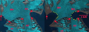
In 2005, we made a reconnaissance of this area (HO-HA-SY), and in 2016, we came back there to investigate and show great changes due to glacial recession under climate warming.There is an environmental-landscape contrast between the eastern and western Spitsbergen coasts due to their climatic differentiation, under the cold sea current from the central Arctic in the east and warm Atlantic water in the west. Its landscape has been changing rapidly since the beginning of the 20th century because of the recession of glaciers. The glacial isthmus has been narrowed from 28 km in 1899-1900 to 5,6 km in 2016 and lowered by 60-200 m during this period. Two isthmus’ glaciers will melt, given the current temperature conditions, by 2030-2035. Hence, Sørkapp Land will become a new big island separated by a new strait (which will origin due to final connection of the Hornsund and Hambergbukta fjords which are being more and more longer). Hambergbukta fjord lengthened about 1,2 km and Hornsund about 1,5 km since 2005.
Greetings from Jagiellonian University, Krakow, Poland.