
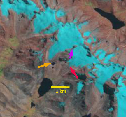
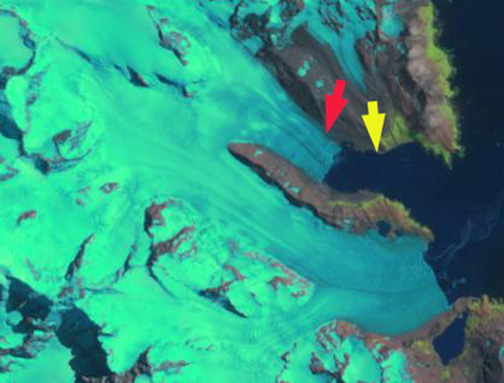
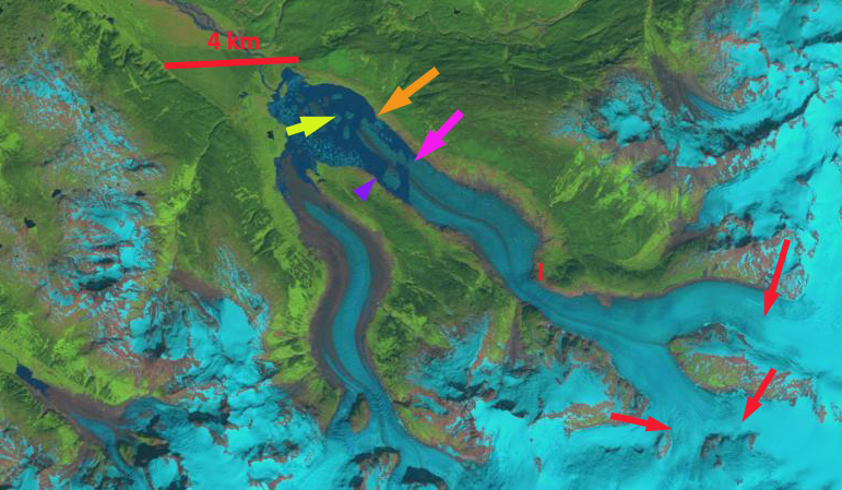
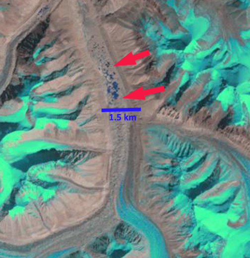
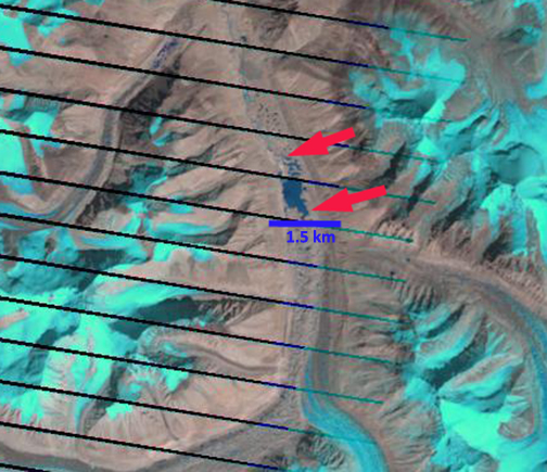
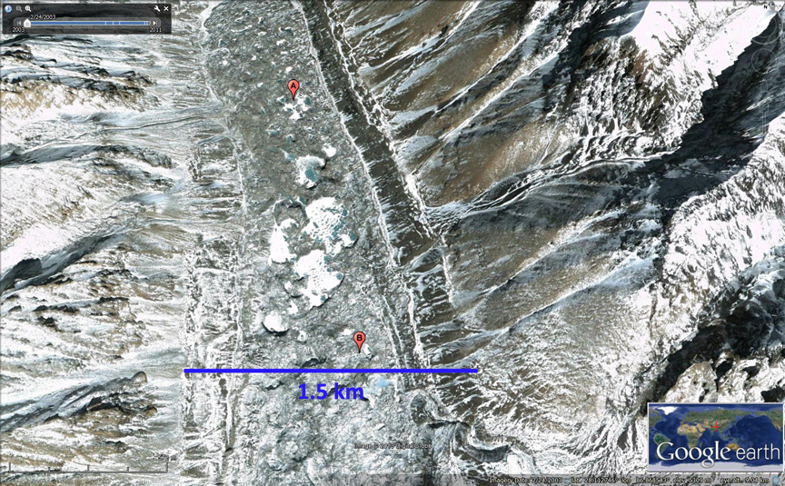
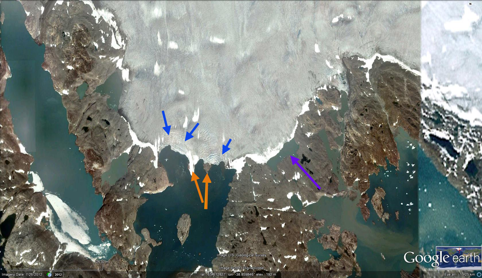
Laramcota Glacier is in the Cordillera Tres Cruces of Bolivia. The glacier feeds into Laguna Laramcota and eventually the Rio Boopi, Rio Beni and finally the Amazon River. The glaciers of Bolivia have received much less scrutiny than those in Peru or Chile, but are quite numerous. Riberio et al (2005) noted a 32% loss of glacier area inn the Tres Cruces from 1972-1999 using satellite imagery. Melocik (2010) in a preliminary report using remote sensing noted a 40% loss in Tres Cruces glacier area from 1985 to 2005. This is a quite a substantial loss, and is likely a maximum loss as some of the area lost at higher elevation could have been non-glaciated snow covered area. Here we examine the changes in Laramcota Glacier using Landsat imagery from 1988 and 2011. The 2.6 km long glacier flows west from 5600 meters to a terminus at 5000 meters.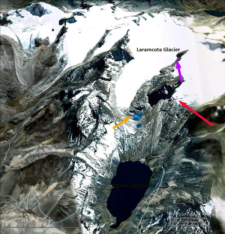 In 1988 the glacier ends at a small lake one kilometer upstream of Laguna Laramcota, orange arrow. The glacier just to the east ends just 600 meters from the Laramcota, red arrow. The ridge separating the two glaciers at the purple arrow is quite narrow. By 2011 the glacier has retreated 300 meters from the lake, orange arrow. The glacier just to the east has retreated 200-300 m as well. The ridge separating the glaciers has expanded considerably in width, purple arrow. The overall loss in glacier from 1988-2011 is 10-15%. The retreat of this glacier fits the pattern of other Bolivian Glaciers, such as the Zongo Glacier or Nevada Cololo and tropical Andean glaciers in general (Rabatel et al, 2013).
Author: mspelto
Professor of Environmental Science at Nichols College in Massachusetts since 1989. Glaciologist directing the North Cascade Glacier Climate Project since 1984. This project monitors the mass balance and behavior of more glaciers than any other in North America
Twitcher Glacier Accelerated Retreat, South Georgia island
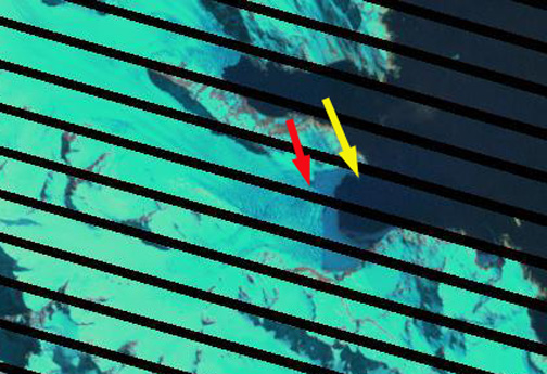
Twitcher Glacier is the next glacier south of Herz Glacier on the east coast of South Georgia. Until 1989 the glacier ended at the tip of a peninsula, the ensuing retreat has led to the opening of a new fjord. Twitcher Glacier was 10 km long and had a 2 km wide calving front in 2009. The terminus change of this tidewater glacier was completed by the British Antarctic Survey for the 1960-2007 period. The glacier retreated 1.5 km between 1960 and 2007, with have of the retreat occurring after 1992. (Gordon et al, 2008). The map below indicates the slow retreat from 1960-1988 and a more rapid retreat since. 
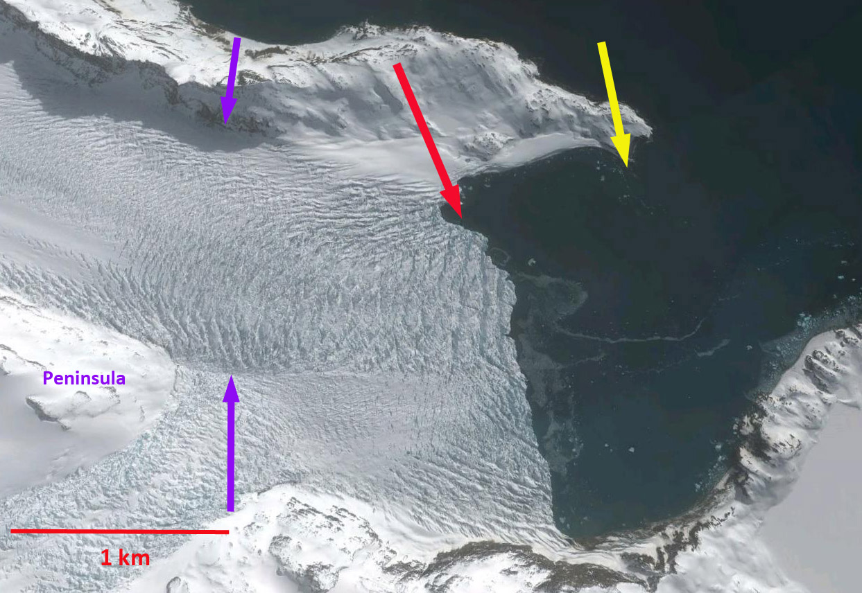
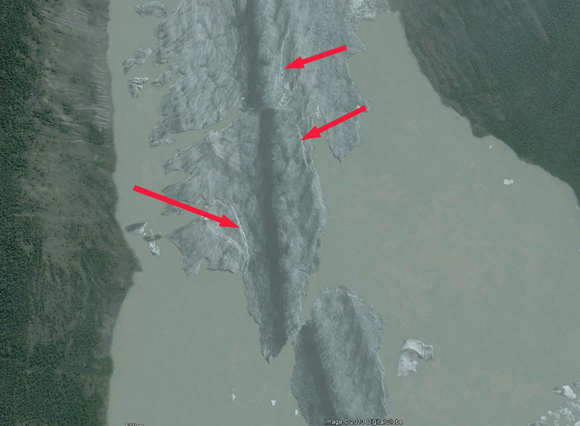
 In 1989 this glacier terminated approximately at the end of a peninsula separating the two glaciers. Here we examine Landsat imagery from 1989, 2000, 2009 and 2013 to identify the rate retreat. The 1989 terminus position is indicated with a yellow arrow and the 2009 terminus position with a red arrow. The retreat is 1.2 km during this period. From 2009 to 2013 retreat accelerated with a further 1.2 km retreat to the purple arrow in the 2013 imagery, the retreat may be even greater but the resolution is poor for the January 1, 2013 image. Notice the lake just south of the glacier terminus in 1989, this lake is evident in the 2000 and 2013 imagery, but is snowcovered in 2013. A 2012 MODIS image has poorer resolution but no cloud cover and indicates the extent of the retreat from the Peninsula the glacier had reached in 1989. The last image is a closeup in Google Earth from 2010 note the significant crevassing which is indicative of rapid flow. The terminus is currently quickly retreating to the next peninsula where the terminus will separate into two parts. The southern tributary already is partly exposed to calving into the fjord. The rapid retreat here is similar to that of Neumayer Glacier or Ross Hindle Glacier.


Herz Glacier Retreat, South Georgia
Herz Glacier is on the southeast coast of South Georgia Island. The terminus change of this tidewater glacier ending in Iris Bay was completed by the British Antarctic Survey for the 1960-2007 period (Gordon et al, 2008). The map below indicates the slow retreat from 1960-1988 and a more rapid retreat since. Here we examine imagery from Google Earth and Landsat to examine terminus change from 1989-2010. In each image the red arrow indicates the location of the terminus in 2009-2010 the yellow arrow the 1989 terminus position. The first image is the Google Earth image from 2010, followed by the 1989, 2000 and 2009 Landsat images. The terminus on the north side of the fjord has retreated 1.8 km in the 20 year period and the terminus on the south side has retreat 2.2 km. The overall 2 km retreat is a rate of 100 meters/year and is 20 % of the total glacier length. This is an exceedingly cloudy region and imagery from 2011 and 2012 does not provide a clear observation of the terminus. The retreat of this glacier is less dramatic than that of Neumayer Glacier or Ross Hindle Glacier further north on the coast.


Porcupine Glacier Retreat and Lake Expansion, British Columbia
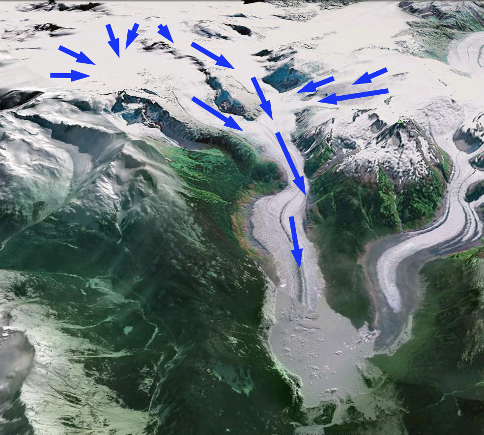
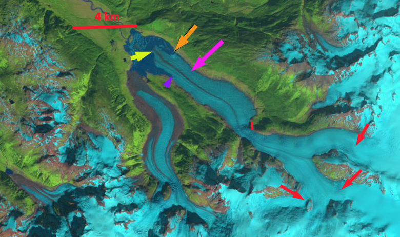
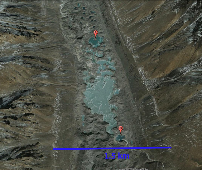
Porcupine Glacier is a 20 km long outlet glacier of an icefield in the Hoodoo Mountains of Northern British Columbia. Bolch et al (2010) noted a reduction of 0.3% per year in glacier area in the Northern Coast Mountains of British Columbia from 1985 to 2005. Scheifer et al (2007) noted an annual thinning rate of 0.8 meters/year from 1985-1999. Here we examine the retreat of Porcupine Glacier and the expansion of the lake it ends in from 1988-2011 using four Landsat images from 1988, 1999, 2010 and 2011. Below is a Google Earth view of the glacier with arrows indicating the flow paths of the Porcupine Glacier. The second images is a map of the region from 1980 indicates a small marginal lake at the terminus.

In 1988 a tongue of the glacier in the center of the lake reached to within 1.5 km of the far shore of the lake, yellow arrow. All but the red arrows are in the same location in each of the images below. The orange image is at the 1988 terminus position on the northern edge of the glacier, the purple arrow indicates the 1988 terminus position on the south side of the glacier. The yellow arrow indicates the 1988 center tongue position. The pink arrow is the 2011 terminus position at the north edge of the glacier. The glacier has retreated 2 km in the 22 year period. The number of icebergs in the lake at the terminus indicates the retreat is mainly due to calving icebergs. Glacier thinning of the glacier tongue leads to enhanced calving. The glacier tongue has a low slope up to an icefall, noted by red I, at this icefall the glacier rises from 450 m to 750 m. This is a likely point at which the lake basin ends and the glacier retreat can slow. The retreat of this glacier is similar to a number of other glaciers in the area Great Glacier, Chickamin Glacier, Patterson Glacier and Bromley Glacier. The terminus viewed up close in 2005 has numerous weaknesses indicating the calving that was going to happen in the next several years.

Krivosheina Glacier Retreat, Novaya Zemlya
Krivosheina Glacier is a tidewater glacier on the northwest coast of Novaya Zemlya ending in the Barents Sea. A recent study by LEGOS (Laboratoire D’Eetudes en Geophysicque et Oceanographie Spatiales) in France highlights the changes of these glaciers from 1990-2000. They note that Krivosheina Glacier lost 3.3 square kilometers of area due to retreat in that decade. Given the recent reduction in Arctic Sea Ice in the region, these glaciers are facing dramatic climate changes. 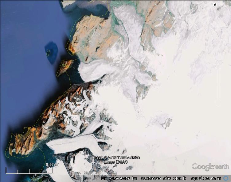 Here we examine satellite imagery from 1988, 2009 and 2011 to identify glacier change. In 1988 the glacier ended on an island, labelled Point A on each image. The north edge of the terminus turned the corner into northwest into a bay just west of Point B. The southern side of the terminus ended at the nose of a ridge just west of Point C. By 2009 a deep water channel was present between the island and the terminus. The north side of the terminus ended just south of Point B and the southern side of the terminus had retreated across the side valley to the east of Point C. By 2011 the terminus had retreated 2 km from its 1988 terminus position on the island and 1400 meters at the south side near Point C. Given that the glacier is 4.6 km wide, this retreat that averaged 1.6 km equals an area loss of 7 square kilometers since 1988. This retreat is similar to that of Nizkiy and Glazova Glacier just to the south and Roze and Sredniy Glacier on the east side of the island.


Rongbuk Glacier Supraglacial Lake Expansion, China
The Rongbuk Glacier is famous as the climbing gateway to the north side of Mount Everest (Qomolangma). In recent years the great climber and mountain photographer David Breashears has highlighted the change of this glacier over a the 1921-2007 period using repeat images of the glacier. The collection is part of Breashears Glacier Works Project, that is chronicling with repeat images the changes in a number of major Himalayan glaciers, the results of which have been in several well traveled exhibits. Here we examine a change on the surface of the main Rongbuk glacier over the last 15 years, the development of a substantial supraglacial lake. Ren et al (2006) noted the retreat of glaciers on the north side of Qomolangma as 5-10 meters/year. Ye et al (2009) noted a loss in glacier of 15 square kilometers for the glacier draining the north side of Qomolangma, and further noted the rapid expansion of the supraglacial lake from 0.05 in 1974 to 0.71 square kilometers in 2008. 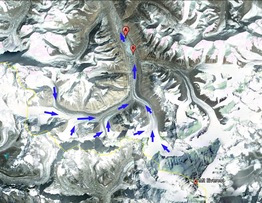 . The red arrows in the Landsat images from 1992, 2001 and 2012 indicate the extent of the supraglacial lake in 2012 , first three images below. In the two Google Earth images from 2003 and 2011, last two images in sequence, the lake extent is marked with point A and B. In 1992 the lower section of the Rongbuk Glacier was heavily debris covered with a isolated melt ponds amidst the rugged debris covered surface. By 2001 some of the melt ponds have coalesced, but a well defined lake is not present. The key to lake expansion is the downwasting of the higher mounds of debris covered ice on the ice tongue. A second key is that the stream exiting the East Rongbuk Glacier now in part feeds this lake system, this could not happen until the glacier surface was low enough for this stream to be able to access the surface. By 2012 the lake has expanded to a length of 1.9 kilometers, and is still expanding in area. A higher resolution view using Google Earth images indicates that most of the lake formation occurred between 2003 and 2011. The terminus is so covered by debris that examining retreat of the front of this glacier is not as important as the thinning of the ice in the lower 8 km of the glacier, which is downwasting rapidly and will melt away. Notice the meltwater stream entering the lake system from the lower right in the 2011 image.
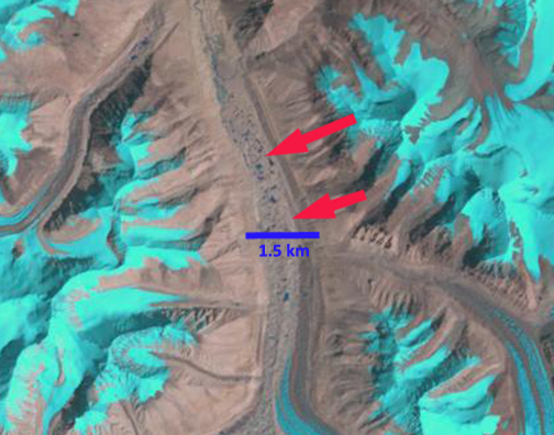
Upglacier of the this lake at the main junction of the Rongbuk Glacier is another area of lakes that could coalesce into the same type of feature. This indicates that this glacier will have to retreat a long ways to reestablish equilibrium. The glaciers behavior reflects the same trends though the specific symptom, surface lake formation is different, as Lumding Glacier, Ngozumpa Glacier and Imja Glacier
Bussemand Gletscher Retreat East Greenland
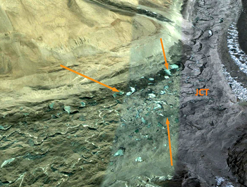
Bussemand Gletscher in East Greenland has a mixed tidewater and land based terminus. This glacier is 50 km west of Tasiilaq and just west of Nattivit Kangertivat Fjord. In this post we compare Landsat imagery from 2000 and 2012 to determine the response of this glacier to recent climate change. Espen Olsen provided the base map below and noted that Bussemand translates to bogey man.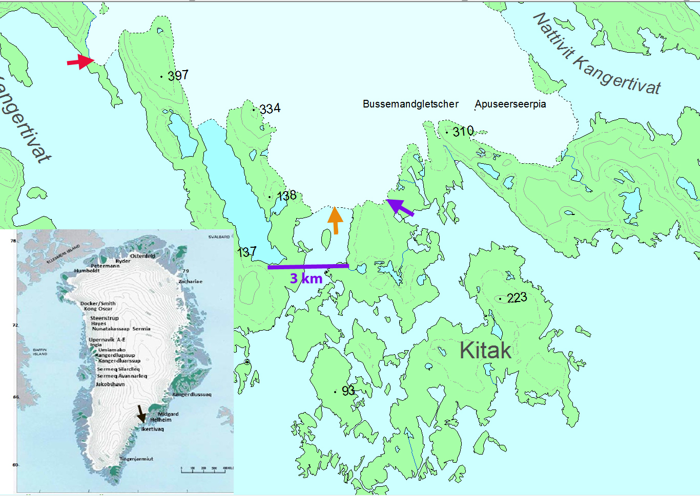 . The first two images below are a 2000 and 2012 Landsat image. On these two images the terminus in three locations is noted. The main tidewater terminus at the orange arrows is exposing a new island or peninsula as it retreats. Two orange arrows point to small prominence’s on the side of the inlet that the glacier almost reached in 2000 and has retreated 800 m from on the west side and 400 m on the east side by 2012. At the purple arrow a new proglacial lake has formed and the terminus retreated 400 m from 2000 to 2012. At the secondary tidewater terminus the glacier has retreated 700 m from the red arrow to the yellow arrow. There are also a series of letters A-F at the same location in each image each highlighting changes. Point A denotes the expansion of a nunatak within the ice. Point B indicates the expansion of a nunatak and the lateral moraine extending from the nunatak; Point C is where an area of bedrock at the margin of the western tidewater terminus has doubled in size. Point D was a small outcrop at the edge of the glacier and is now a developing peninsula. Point E was a narrow connection to the neighboring Apuseerseerpia Glacier that is now bedrock. Point F is a location where several new bedrock knobs have emerged at the surface of the glacier. Collectively they indicate the thinning of the glacier across its entire front and several kilometers inland of the front.
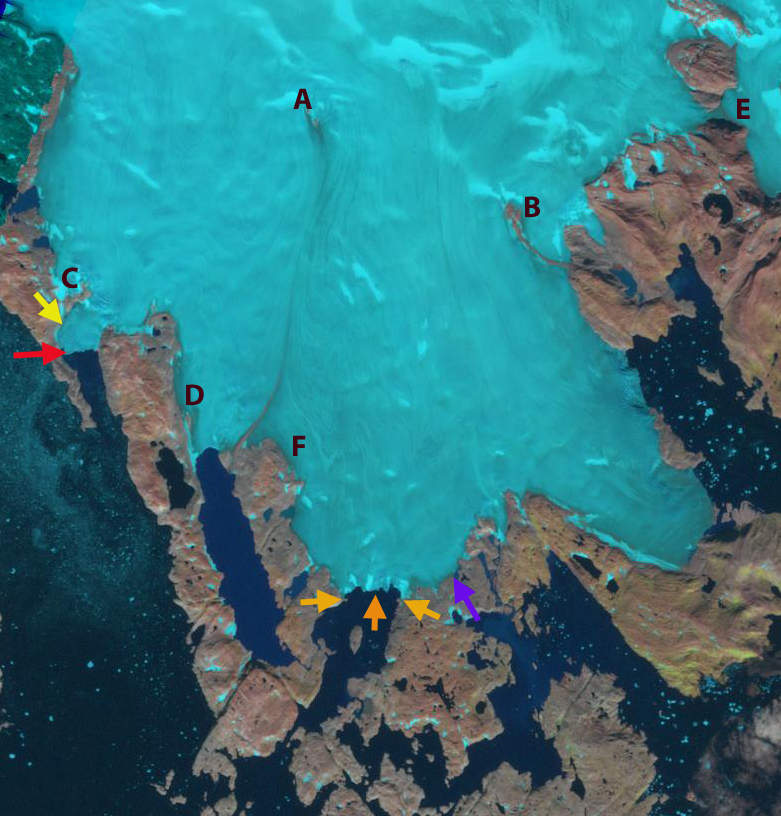

Below is a closeup of the terminus the two active calving embayments are indicated with blue arrows. As these narrow and the water depth drops, calving will be reduced. However, it is not clear that there is not embayment inland of this point where the proglacial lake is developing at the purple arrow. Note the channels for example between Kitak Island and the mainland in the first image. The retreat of this glacier follows that of other glaciers in the region big and small. Mernild et al (2012) noted the widespread retreat of many small glaciers including Mittivakkat. Larger glaciers were detailed by Bjork et al (2012), for example Apuserajik and Thrym.
Obersulzbach Glacier Retreat, Austria
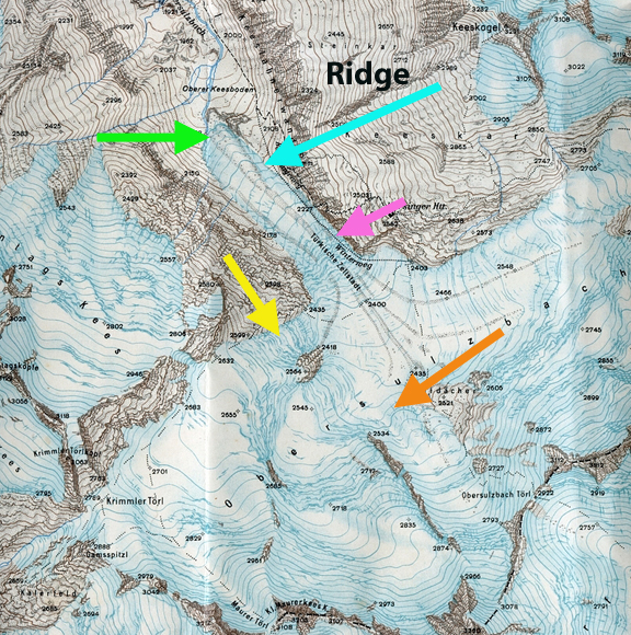
The Obersulzbach Glacier, is situated in the uppermost part of the Obersulzbach Valley, which feeds the Salzach River system in Austria. The Salzach is fed by many glaciers covering over 100 square kilometers (Koboltschnig and Schoner, 2011). These glaciers melt all summer providing considerable runoff to the numerous hydropower projects along the Salzach, that can produce 260 MW of power. The Verbund Power Plant producing 13 MW is seen below, at blue arrow.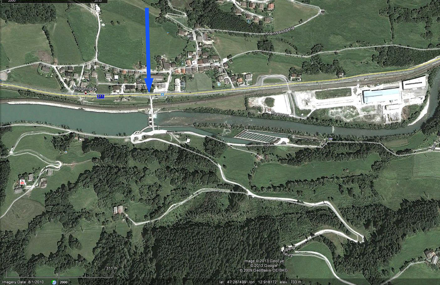 The glacier has receded in a narrow bedrock basin since the late 1990’s and a shallow lake, Obersulzbach-Gletschersee, has formed since 1998 (Geilhausen et al, 2012). (Geilhausen et al, 2012) observed that in 2009, the lake had an area of 95,000 m2 with a maximum depth of 42 m. Nick Fisher sent me a map of the glacier prepared by the Austiran Military in the early 1930’s this is compared to the GE image of the glacier from 2000, below. The green arrow indicates the 1930’s terminus extending due east from the nose of a ridge and the blue arrow parallels a prominent ridge somewhat above the terminus. The pink arrow in these images and in the Landsat images further below indicates the 1988 terminus position, the yellow arrow the mid section of a glacier tongue from the west that rejoined the main terminus in 1988, the orange arrow the top of a cliff where the eastern tributary ended in 1988. As Nick has noted: Since 1934,the glacier has retreated about 1.6 km,from a terminus at 1980 m, and the proglacial lake lies just behind where once was a magnificent ice fall known as the Turkische Zeltstadt (Turkish Tent City). The Zeltstadt is now a series of waterfalls. According to my map, in 1934 the ice was at least 150 m deep over the current lake surface,where all the glacier streams united before heading down the ice fall.
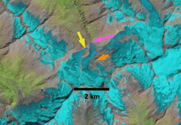
 The World Glacier Monitoring Service reports indicate the glacier retreated 140 meters from 1991-2000 and 345 m from 2001-2010. Here we examine Landsat imagery from 1988, 1998, 2011 and 2012 to identify the retreat of this glacier and formation of the new lake. The pink arrow in each image indicates the 1988 terminus position, the yellow arrow the mid section of a glacier tongue from the west that rejoined the main terminus in 1988, and the orange arrow the top of a cliff where the eastern tributary ended in 1988. By 1998 a small lake less than 100 m long has formed at the end of the glacier. By 2011 and 2012 the lake has grown to a length of 450 m and a with of over 200 meters. The main terminus has retreated 450 to 500 m in the last 25 years. The western tongue at the yellow arrow no longer connects to the main terminus in 1998. By 2011 and 2012 the western tongue is separated by 600 meters from the main terminus. The eastern tongue has retreated 400 m from the cliff by 2012.


A closeup view of the terminus in 2003 from Google Earth indicates the lake development in three small locations around the terminus at the blue arrows. This glaciers retreat fits the pattern of other glaciers in the Austrian Alps, Oberaar Glacier, Rotmoosferner and Ochsentaler. 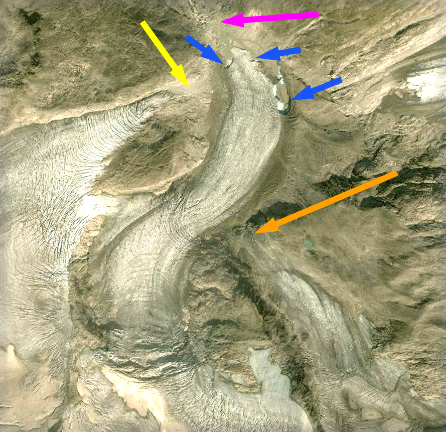
Glacier Posts through March 2013:
Below is a list of the individual glacier posts examining our warming climates impact on each glacier. This represents the first 3.7 years of posts, 283 total posts, 257 different glaciers. I have worked directly on 49. The others are prompted by fine research that I had come across, cited in each post or inquiries from readers and other scientists. I then look at additional often more recent imagery to expand on that research. The imagery comes either from MODIS, Landsat, Geoeye or Google Earth. There is a consistent signal from the glaciers, mass balance loss, thinning and retreat. In many cases this leads to new lake formation or lake expansion for alpine glaciers. I will continue to record these changes here with a new post twice a week and in the field this summer as is the case every summer since 1981.
United States
Columbia Glacier, Washington
Lyman Glacier, Washington
Whitechuck Glacier
Boulder Glacier, Washington
Roosevelt Glacier
Deming Glacier Icefall, Washington
Deming Glacier, Washington
Lower Curtis Glacier Annual Survey, Washington
Easton Glacier Assessment, Washington
Mount Baker Mass balance, Washington
Ptarmigan Ridge Glacier, Washington
Dusty Glacier, Washington
Anderson Glacier, Washington
Eel Glacier, Washington
Milk Lake Glacier, Washington
Suiattle Glacier, Washington
Paradise Glacier, Washington
Easton Glacier, Washington
Redoubt Glacier, Washington
Honeycomb Glacier, Washington
Vista Glacier, Washington
Rainbow Glacier, Washington
Daniels Glacier, Washington
Colonial Glacier, Washington
Quien Sabe Glacier, Washington
Mazama Glacier
Fairchild Glacier, Washington
White Glacier, Washington
Banded Glacier, Washington
Borealis Glacier, Washington
Hinman Glacier, Washington
Lower Curtis Glacier, Washington
Mount Baker Glaciers, Washington
McAllister Glacier, Washington
Lewis Glacier, Washington
Kennedy Glacier, Washington
Fremont Glacier, Wyoming
Minor Glacier, Wyoming
Knife Point Glacier, Wyoming
Bastion Glacier, Wyoming
Sourdough Glacier, Wyoming
Grasshopper Glacier, Wyoming
Grasshopper Glacier, Montana
Harrison Glacier, Montana
McDonald Glacier, Montana
Sperry Glacier, Montana
Hopper Glacier, Montana
Old Sun Glacier, Montana
Yakutat Glacier, Alaska
Grand Plateau Glacier, Alaska
Eagle Glacier, Alaska
Gilkey Glacier, Alaska
Fork Glacier, Alaska
Gilkey Glacier ogives, Alaska
Norris Glacier
Lemon Creek Glacier, Alaska
Taku Glacier, Alaska
Bear Lake Glacier, Alaska
Riggs Glacier
Chickamin Glacier, Alaska
Okpilak Glacier, Alaska
Sawyer Glacier, Alaska
Valdez Glacier, Alaska
Antler Glacier, Alaska
Field Glacier
East Taklanika Glacier, Alaska
Gold Rush Glacier
Brady Glacier, Alaska
Brady Glacier Retreat lake expansion 2004-2010, Alaska
Thiel Glacier, Alaska
Speel Glacier, Alaska
Patterson Glacier, Alaska
Romanzof Glacier, Alaska
Pedersen Glacier, Alaska
Canada
Icemantle Glacier, BC
Bridge Glacier, British Columbia
Snowcap Creek
Stave Glacier, British Columbia
Washmawapta Glacier, British Columbia
Bubagoo Glacier, British Columbia
Hector Glacier, Alberta
Helm Glacier, British Columbia
Jacobsen Glacier, British Columbia
Melbern Glacier
Warren Glacier, British Columbia
Castle Creek Glacier, British Columbia
Hoboe Glacier, British Columbia
Coleman Glacier, British Columbia
Tulsequah Glacier, British Columbia
Des Poilus Glacier, British Columbia
Decker and Spearhead Glacier, British Columbia
Columbia Glacier, British Columbia
Freshfield Glacier, British Columbia
Apex Glacier, British Columbia
Great Glacier, British Columbia
Devon Ice Cap, Nunavut
Dexterity Ice Cap Baffin Island
Penny ice Cap, Nunavut
Northern Outlet Devon Ice Cap, Nunavut
Penny Ice Cap SW, Nunavut
Mittie Glacier, Ellesmere Island, Nunavut
Snowshoe Peak, Yukon
Petain Glacier, Alberta
Saskatchewan Glacier, Alberta
Himalaya
Ngozumpa Glacier, Nepal
West Barun Glacier, Nepal
Khumbu Glacier, Nepal
Imja Glacier, Nepal
Reqiang Glacier Retreat, Nepal
Kali Gandaki Headwaters, Nepal
Samudra Tupa, India
Malana Glacier, India
Warwan Basin, India
Sara Umaga Glacier, India
Zemu Glacier, Sikkim
North Lhonak Glacier, Sikkim
Changsang Glacier, Sikkim
Gangotri Glacier, India
Milam Glacier, India
Satopanth Glacier, India
Theri Kang Glacier, Bhutan
Zemestan Glacier, Afghanistan
Emend River Headwaters, Afghanistan
Yajun Peak Glacier, Afghanistan
Godur Glaicer, Pakistan
Tirich Mir, Pakistan
Longbasba Glacier, Tibet
Menlung Glacier, Tibet
Boshula Glaciers, Tibet
Urumquihe Glacier, Tibet
Lumding Glacier, Tibet
Matsang Tsanpo Glacier, Tibet
Dzhungharia Alatau, Kazakhstan
Petrov Glacier,Kyrgyzstan
Hailuogou Glacier, China
Sepu Kangri, China
Himalaya Glacier Index
Europe
Taconnaz GLacier, France
Mer de Glace, France
Dargentiere Glacier, France
Glacier de la Girose
Glacier Blanc
Grand Motte and Pramort Glacier Tignes Ski area, France
Saint Sorlin, France
Sommelier Glacier, France
Obeeraar Glacier, Austria
Rotmoosferner, Austria
Stubai Glacier, Austria
Hallstatter Glacier, Austria
Ochsentaler Glacier, Austria
Pitzal Glacier, Austria
Dosde Glacier, Italy
Presena Glacier, Italy
Forni Glacier, Italy
Careser Glacier, Italy
Lobbia Glacier, Italy
Sabbione Glacier Retreat, Italy
Triftgletscher, Switzerland
Gietro Glacier, Switzerland
Ried Glacier, Switzerland
Cavagnoli Glacier, Switzerland
Chuebodengletscher and Ghiacciaio-del-Pizzo-Rotondo, Switzerland
Peridido Glacier, Spain
Maladeta Glacier, Spain
Engabreen, Norway
Midtdalsbreen, Norway
Tunsbergdalsbreen, Norway
Lodalsbreen, Norway
Rembesdalsskaka, Norway
TungnaarJokull, Iceland
Langjökull, Iceland
Gigjokull, Iceland
Porisjokull, Iceland
Skeidararjokull, Iceland
Kotlujokull, Iceland
Lednik Fytnargin, Russia
Kirtisho Glacier, Georgia
Lednik Kauraugom, Russia
Irik Glacier, Mount Elbrus, Russia
Greenland and European Arctic
Mittivakkat Glacier
Ryder Glacier
Humboldt Glacier
Petermann Glacier
Kuussuup Sermia
Thrym Glacier Retreat
Tiningnilik Glacier Lake
Jakobshavn Isbrae
Zachariae Isstrom
Umiamako Glacier
Alison Gletscher
Kong Oscar Glacier
De Reste Bugt
Qaleraliq Glacier
Upernavik Glacier
Apuserajik Glacier
Epiq Sermia
Dodge and Storm Glacier
Sarqardliup Seremia
Steensby Glacier
Sortebrae Glacier, Greenland
Narssap Sermia
Severnaya Zemlya, Russian Arctic
Hansbreen, Svalbard
Nannbreen, Svalbard
Hornbreen and Hambergbreen, Svalbard
Olsokbreen, Svalbard
Albrechtbreen, Svalbard
Svitjodbreen, Svalbard
Roze and Sredniy Glacier, Novaya Zemyla
Nizkiy and Glazova Glacier, Novaya Zemyla
South America
Colonia Glacier, Chile
Glaciar Steffen, Chile
Artesonraju Glacier, Peru
Nef Glacier, Chile
Tyndall Glacier, Chile
Alemania Glacier, Chile
Zongo Glacier, Bolivia
Sierra Nevade del Cocuy Glaciers, Colombia
Ritacuba Blanco Glacier, Colombia
Llaca Glacier, Peru
Joerg Montt Glacier, Chile
Nororeste Glacier, Chile
Arhuey Glacier, Peru
Seco Glacier, Argentina
Onelli Glacier, Argentina
Quelccaya Ice Cap, Peru
Manon Glacier, Peru
Corihuasi Glacier, Peru
Chuecon Glacier
Glacier Gualas, Chile
Antarctica and Circum Antarctic Islands
Pine Island Glacier
Fleming Glacier
Hariot Glacier
Smith Glacier, Antarctica
Thwaites Glacier, Antarctica
Amsler Island
Stephenson Glacier, Heard Island
Neumayer, South Georgia
Ampere, Kerguelen
Lapparent Outlet, Kerguelen Island
Cook Ice Cap, Kerguelen Island
Nordenskjold Coast, Antarctic Peninsula
Prospect Glacier, Antarctic Peninsula
Ross Hindle Glacier, South Georgia
Vega Island Ice Cap
Rohss Bay, James Ross Island, Antarctica
Jones Ice Shelf, Antarctica
Sheldon Glacier, Antarctica
New Zealand
Tasman Glacier
Tasman Glacier 2013 update
Murchison Glacier
Donne Glacier
Mueller Glacier, NZ
Gunn Glacier, NZ
Douglas Glacier Neve, NZ
Africa
Rwenzori Glaciers
Tyndall Glacier, Kenya
North Cascade Glacier Climate Project Reports
Forecasting Glacier Survival
North Cascade Glacier Mass Balance 2010
Columbia Glacier Annual Time Lapse
North Cascade Glacier Climate Project 2009 field season
28th Field Season Schedule of the North Cascade Glacier Climate Project
North Cascade Glacier Climate Project 2011 Field Season
BAMS 2010 alpine glaciers
BAMS 2011 Alpine Glaciers
2011 Glacier mass balance North Cascades and Juneau Icefield
Taku Glacier TSL Paper
Glacier Ground Truth 2012 North Cascade Field Season
North Cascade Glacier Climate Project 2012 Field Season
Dexterity Ice Cap, Baffin Island
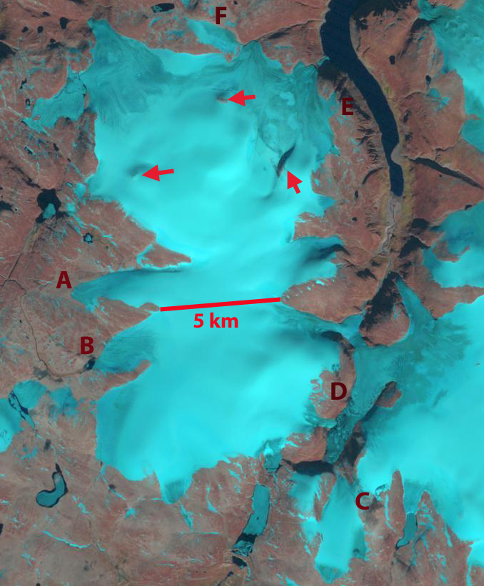
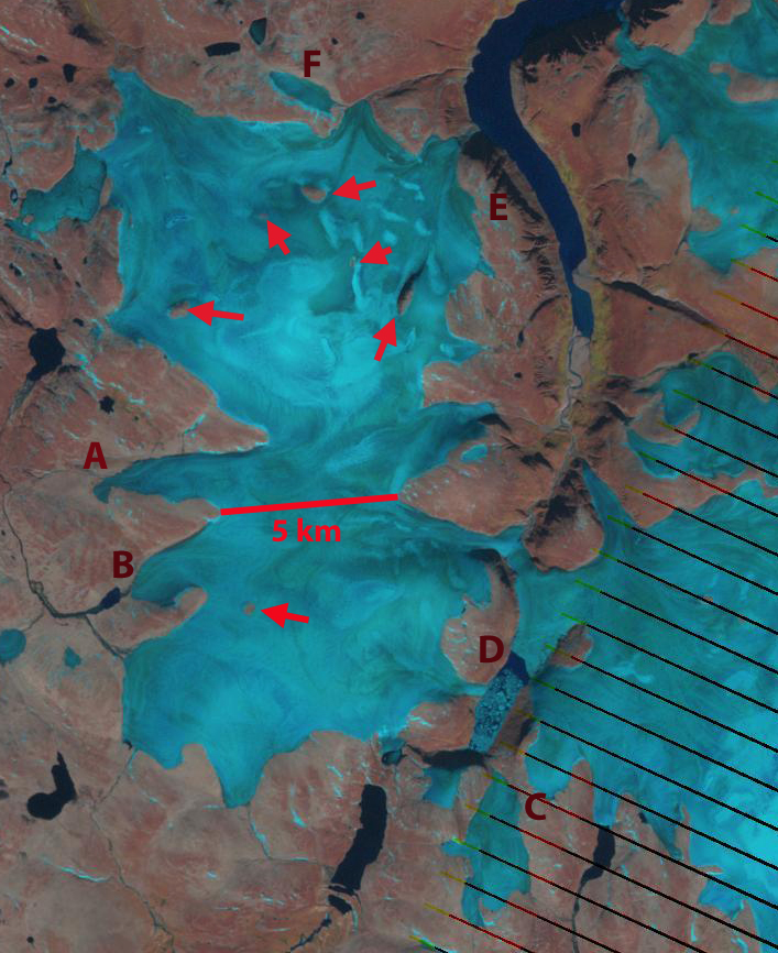
At the south end of Dexterity Fjord on the northeast coast of Baffin Island is an unnamed icecap that I will refer to as Dexterity Icecap. Gardner et al (2012). Gardner et al 2011 and Sharp et al (2011) both note that the first decade of the 21st century had the warmest temperatures of the last 50 years, the period of record. identified that the mass loss had doubled in the last decade versus the previous four for Baffin Island.  Landsat images from 1990, 1994 and 2011 are used to assess the changes in this icecap. Red arrows are used to identify nunataks within the icecep, bedrock islands amidst the glacier. In 1990 and 1994 there are three evident nunataks. By 2011 there are six nunataks indicating this ice cap is thinning. In 2011 the ice cap has only 5-10% snowcover, the rest has melted away, not a good sign for an ice cap. There are a series of letters A-F on each image indicating particular locations. It is evident that the terminus has shrunk in width in particular in 2011 from the 1990’s. At Point B the glacier has receded from the edge of a small lake. At Point C a small ice cap has separated from its larger neighbor between the 1990’s and 2011. At Point D it is difficult to discern the terminus in the lake in 1990 and 1994. That the lake is open in 2011 and has numerous icebergs and the open water can absorb more heat from the sun, suggests that this terminus could suffer from enhanced melting and calving going forward. Point E represents a small tongue of ice that in the 1990’s extended to the top of gully, but by 2011 was gone. Point F indicates an ice cap that has a very tenuous connection to the Dexterity Ice Cap. It is the width of the ice cap that has diminished the most from 800-900 meters in the 1990’s to 500-600 m in 2011. The retreat of Dexterity Ice Cap is similar to that of Penny Ice Cap further south on Baffin Island and Devon Ice Cap further north in the Canadian Arctic. A paper out this past week concludes that there is an ongoing irreversible mass loss of glaciers in the Canadian Arctic Lenearts et al (2013).

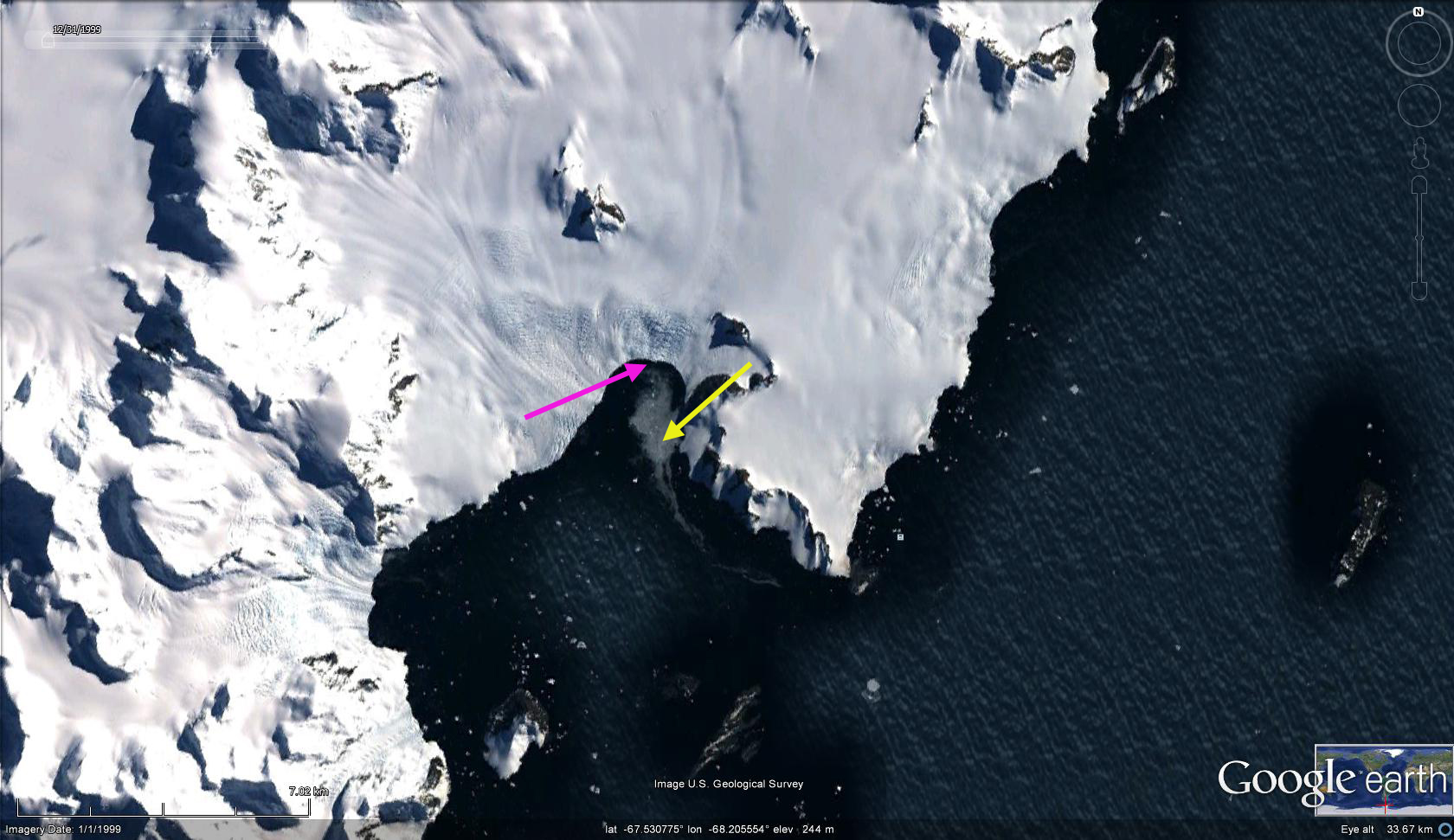
Sheldon Glacier retreat, Adelaide Island, Antarctica
Sheldon Glacier drains east from Adelaide Island and is close to the British Antarctic Survey (BAS) Rothera Research Station. This research camp has a webcam if you want to see current conditions. Adelaide Island is off the west side of the Antarcitc Peninsula, the first image is from the USGS-BAS joint mapping project Ferigno et al (2008). In this region the BAS completed a study ((Cook et al, 2005) that indicated that 87% of the 244 marine terminating glaciers in the area were retreating over the last 60 years. This ongoing BAS study generated maps such as the one of Sheldon Glacier indicating the retreat of the north portion of the terminus of 2.5 km and 1 km of the southern section from 1947-2007.
  . An examination of the terminus of the glacier from a 1991 Landsat, 1999 Google Earth, 2011 and 2013 Landsat image indicate the retreat. The yellow arrow points to the same location off a prominent peninsula, where the glacier terminated in 1991. The pink arrow indicates the terminus position in 2013 in each image. The pink arrow is at the base of an icefall, the extensive crevassing creating the darker blue and varied colors. The retreat from 1991 to 2013 in this embayment at the northern edge of the glacier front has been 2 kilometers. If this retreat has been due to either basal melt enhanced rifting and accelerated calving as noted at Fleming Glacier or Jones Ice Shelf, this process will have ended in the embayment, as the icefall would indicate a rise in the bed elevation beneath the glacier.


Patterson Glacier Retreat, Southeast Alaska
Patterson Glacier is a western outlet of the Stikine Icefield in southeast Alaska. The glacier does not reach tidewater it is 23 km long and has an area of about 100 km2. At the end of the 19th century, the terminus flowed both the east and the west, and was slowly advancing. William O. Field visited the glacier in 1941 and 1948 and found a 1.3 km retreat since the late 19th century. By 1979 the USGS noted a further 1 km of retreat. I saw the glacier enroute to the Juneau Icefield in 1984 and the lake at the terminus was still rather small. I talked to William O. Field right after that field season, he was convinced that all Stikine Icefield glaciers would be retreating more and we discussed Baird Glacier just to the north because it has not retreated yet, though it is showing signs now. In this post we examine the changes between 1985 and 2011 using Landsat imagery. Since 1984 frequent satellite imagery allows identification of the equilibrium line altitude (ELA), the snowline at the end of summer where accumulation equals ablation that year. The average ELA has been 1150 m, which given that the main accumulation zone ends at 1350 m is too high to maintain equilibrium. The green arrows indicate flow directions in the Google Earth image below. The yellow arrow the 1985 terminus, the red arrow the 2011 terminus, the blue arrows the snowline and the pink arrow a peninsula where a prominent debris band is located in 2011, that is also marked by the letter D. The debris band represents an avalanche that descended onto the glacier not too long before 1985. Glacier velocity is faster in the center and this fairly round debris will quickly become drawn down glacier faster in the center than at its edge, this had not notably occurred yet in 1985. 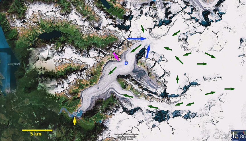 A comparison of the 1985 Landsat image of Patterson Glacier and 2011 Landsat image indicate that the debris band (D) has shifted 3000 meters down glacier in 27 years, indicating approximately 110 meters per year velocity for the north side of the Patterson Glacier valley tongue. The terminus has retreated from the yellow to the red arrow a distance of 1200 meters, a rate of 45 m/year. The terminus lake is 2 km long in 2011. The 2011 terminus is quite narrow indicating the glacier maybe reaching the eastern end of this lake basin. A close up of the terminus area in Google Earth indicates the same features, orange arrows indicate the east and west flow at the terminus that was observed in the late 19th century. This glacier is responding very similarly to Speel Glacier, Great Glacierand Norris Glacier of the Juneau Icefield


