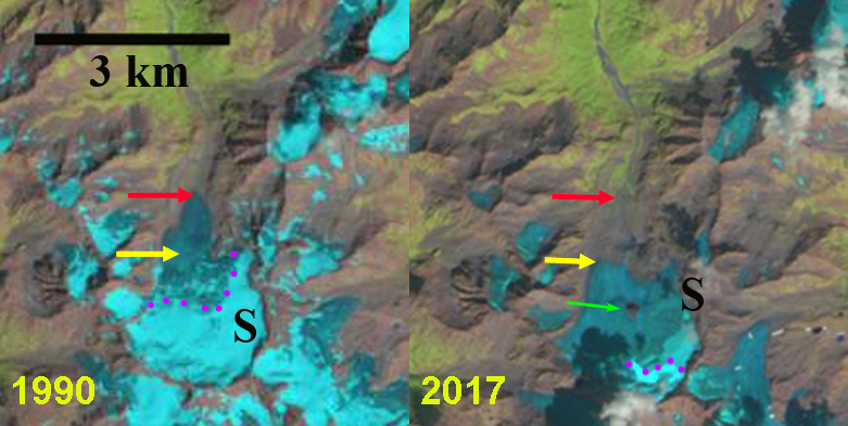
Schlegies (S), Furtschagl (F), Hornkees (H) and Waxeggkees ![]() in 1990 and 2017 Landsat images. Red arrows indicate the 1990 terminus location and pink arrows indicate locations where the Schlegies (S) and Furtschagl (F) separated. Schlegies Reservoir (SC) near top.
in 1990 and 2017 Landsat images. Red arrows indicate the 1990 terminus location and pink arrows indicate locations where the Schlegies (S) and Furtschagl (F) separated. Schlegies Reservoir (SC) near top.
In August, 1990 you could have skied 5.5 km across the width of the Schlegies (S) and Furtschagl (F) Glaciers in the Zillertal Alps, Austria without taking your skis off. By August 2017 this traverse would have necessitated removing your skis three times as marginal retreat has led to glacier segmentation. These glaciers feed the Schlegeis Reservoir and hydropower system, and along with the adjacent Waxeggkees ![]() and Hornkees (H) provide a good example of Austrian Glacier retreat and area loss that has led to glaciers separating into smaller segments. The Austrian Alpine Club conducts an annual survey of terminus change, supervised by Andrea Fischer, on nearly 100 glaciers. In 2016, 87 of the 90 glaciers surveyed retreated with the greatest retreat being 65 m at Hornkees (Fischer, 2017). In 2017, the survey examined 83 glacier, with 82 retreating (Fischer 2018). The average retreat of 25.2 m was the largest since 1960 and was attributed to the snow poor winter of 2016/17 and warm summer of 2017 (Fischer 2018). The second largest retreat was of Waxeggkees at 120 m. The high rate of retreat of these two Zillertal glaciers indicates the significance of climate change on glaciers in this region. Verbund the largest electricity generating company in Austria operates the Schlegies-Rosshag Hydropower pumped storage facility that can generate 231 MW. Because it is pumped storage it is not as vulnerable as the run of river hydropower plants that Verbund operates.
and Hornkees (H) provide a good example of Austrian Glacier retreat and area loss that has led to glaciers separating into smaller segments. The Austrian Alpine Club conducts an annual survey of terminus change, supervised by Andrea Fischer, on nearly 100 glaciers. In 2016, 87 of the 90 glaciers surveyed retreated with the greatest retreat being 65 m at Hornkees (Fischer, 2017). In 2017, the survey examined 83 glacier, with 82 retreating (Fischer 2018). The average retreat of 25.2 m was the largest since 1960 and was attributed to the snow poor winter of 2016/17 and warm summer of 2017 (Fischer 2018). The second largest retreat was of Waxeggkees at 120 m. The high rate of retreat of these two Zillertal glaciers indicates the significance of climate change on glaciers in this region. Verbund the largest electricity generating company in Austria operates the Schlegies-Rosshag Hydropower pumped storage facility that can generate 231 MW. Because it is pumped storage it is not as vulnerable as the run of river hydropower plants that Verbund operates.
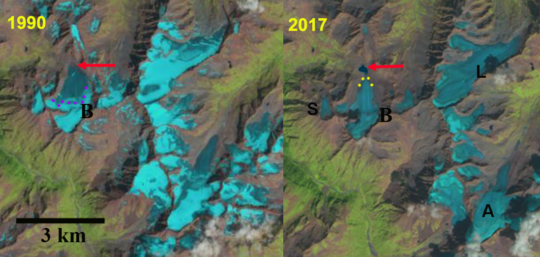
In 1990 Hornkees and Waxeggkees have significant valley tongues extending from the upper accumulation zone. Schlegies and Furtschagl is a 5.5 km wide continuous accumulation zone. By 1998 Schlegies, Furtschagl, Hornkees and Waxeggkees have all retreated significantly. By 2013 Waxeggkees has lost its terminus tongue and is now has a broad slope terminus. In 2017 Schlegies has separated into three parts and has not retained any snowpack from 2017. Schlegeis has 500-650 m across its broad front from 1990 to 2017. Furtschagl has separated from Schlegeis as well. Furtschagl has retreated 350 m from 1990-2017, m in 2017. Hornkees main terminus has retreated 850 m from 1990-2017, 86 m from 2015-2017. Waxeggkees main terminus has retreated 700 m from 1990 to 2017, including 152 m from 2015-2017. The mean thickness of Waxeggkees and Hornkees was 30 m and 28 m in 1999, (Fischer and Kuhn, 2013). The thickness will have decline with area loss since, Fischer et al (2015) note that Austrian glacier have been losing area at a rate of 1.2% annually after 1998.
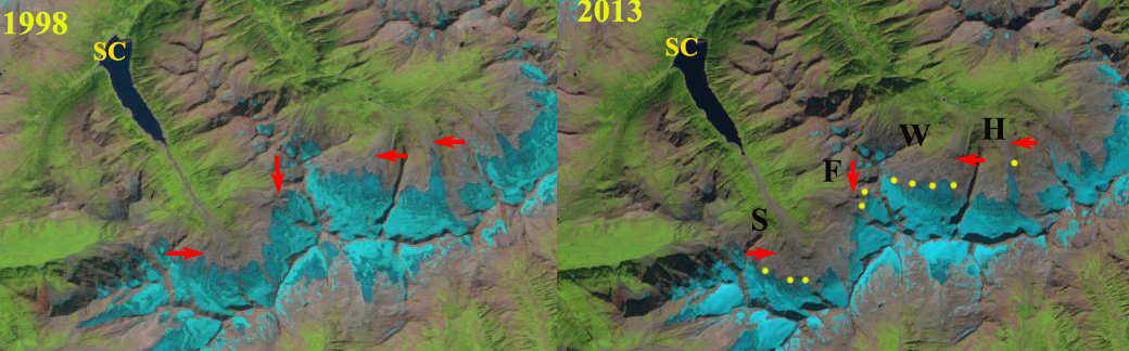
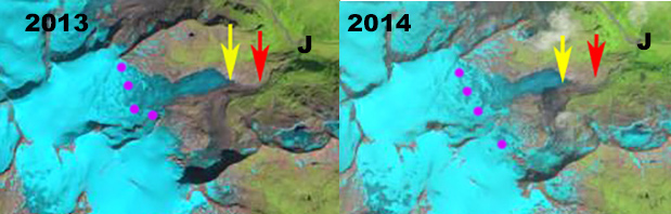
Schlegies (S), Furtschagl (F), Hornkees (H) and Waxeggkees ![]() in 1998 and 2013 Landsat images. Red arrows indicate the 1990 terminus location and yellow dots indicate the 2013 terminus.
in 1998 and 2013 Landsat images. Red arrows indicate the 1990 terminus location and yellow dots indicate the 2013 terminus.

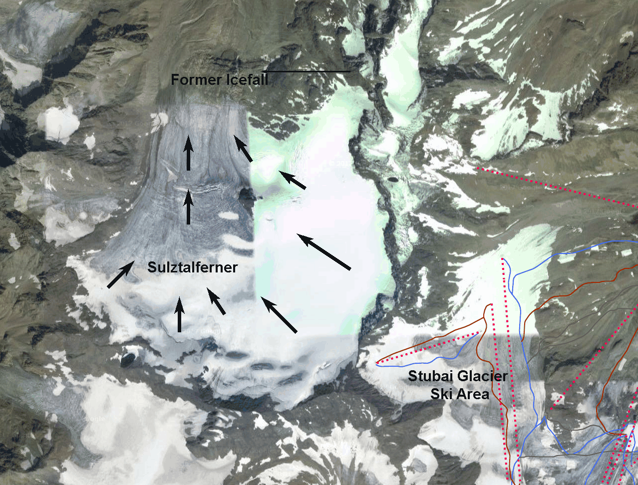
Schlegies (S), Furtschagl (F), Hornkees (H) and Waxeggkees ![]() In Google Earth image.
In Google Earth image.