Nevado Soral, Bolivia Glacier Retreat Separation Imminent 1988-2016

nevado soral compare

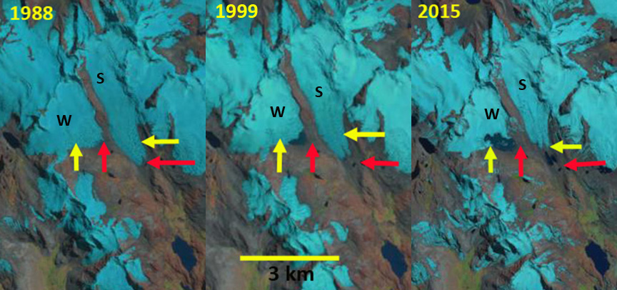
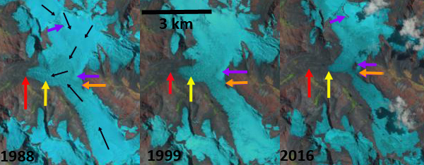
Landsat comparison from 1988 to 2016 of Nevado Soral Glaciers, Bolivia.  Red arrow is the 1988 terminus, yellow arrow the 2016 terminus, orange arrow is the glacier junction and the purple arrow areas of rock expansion indicating upglacier thinning.

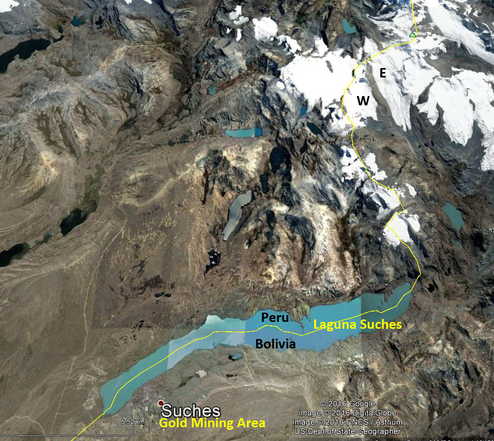
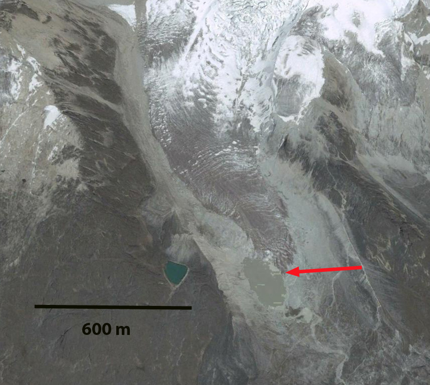
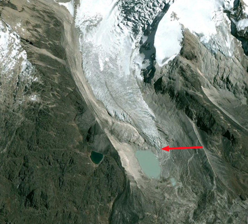
Nevado Soral is in the Cordillera Apolobamba Range of the Bolivian Andes.  A significant valley glacier flows south from the mountain joining a northward flowing glacier shortly above the terminus.  The combined runoff of these glaciers drains in to Laguna Suches, which is transected by the Bolivia-Peru Border.  Cook et al (2016)  quantify the importance of the Bolivian Andes Glaciers for  water supply for Andean cities and mountain communities.  They used Landsat satellite imagery to identify an overall areal shrinkage of 228 km2 (43%) across the Bolivian Cordillera Oriental between 1986 and 2014, including 43% in the Cordillera Apolobamba, where Nevado Soral is located.  Retreat has led to a growing number of lakes, although the number of ice-contact lakes has decreased.  Vuille et al (2008) noted that air temperature in the Andes has increased by approximately 0.1 °C/decade, with only two of the last 20 years being below the 1961–90 average.  Soruco et al 2009) observed glacier change in the Cordillera Real of Bolivia and determined  that between 1963 and 2006 the mass of these glaciers has clearly been decreasing since 1975 without any significant acceleration of this trend over recent years.  The net result was that  glaciers lost 43% of their volume between 1975 and 2006. On nearby Chaupi Orko Glacier retreat has been less extensive, but several new lakes have formed in the last two decades.

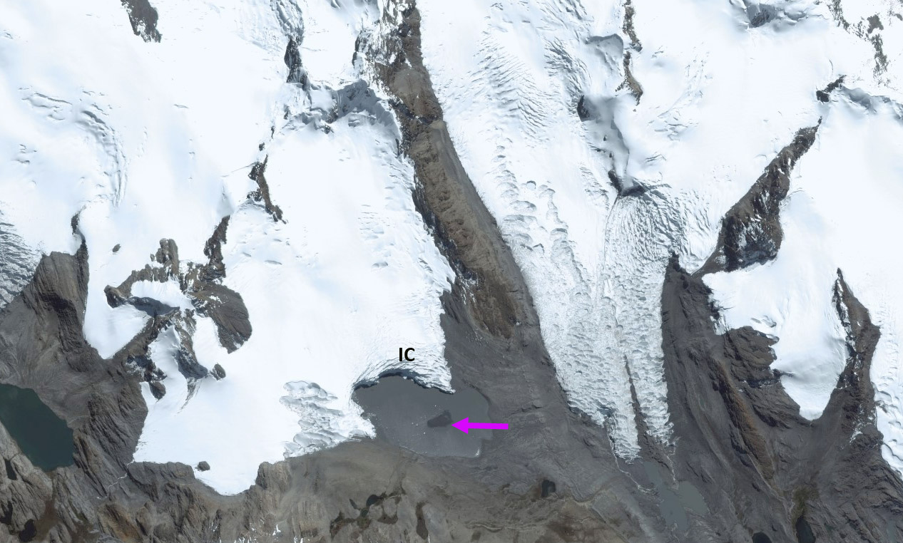
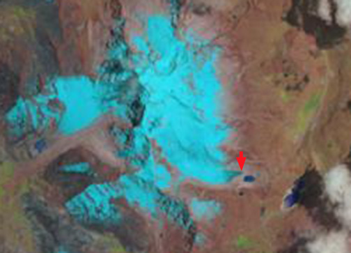
In 1988 the junction where the north and south flowing glacier meet and turn west is 800 m wide, orange arrow.  The main glacier terminus is at m, red arrow. The purple arrows indicate areas where no bedrock is exposed. In 1999 there is 250-300 m of retreat and bedrock is still not exposed at the purple arrows.  By 2016 the main terminus has retreated 800 m since 1988.  The junction of the glacier is only 300 m wide.  The purple arrows indicate locations where bedrock has been exposed by glacier thinning. A Google Earth closeup below indicates significant ablation hollows, and few surface streams, suggesting that sublimation is an important means of ablation on the glacier.  The narrow junction of the two glaciers will soon melt, leaving two separate glaciers.

suches glacier ge

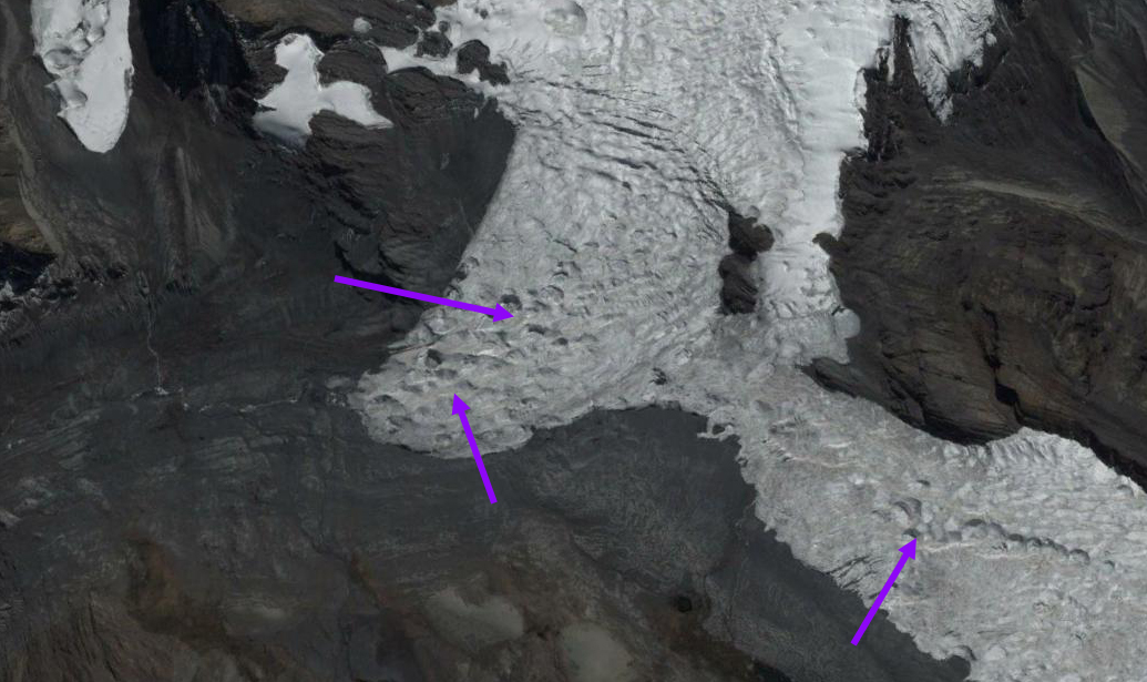
Terminus zone of Nevado Soral Glacier.  Purple arrows indicate ablation hollows are as common as stream channels.  This typifies an area where sublimation is a significant source of ablation.

nevado soral landsat


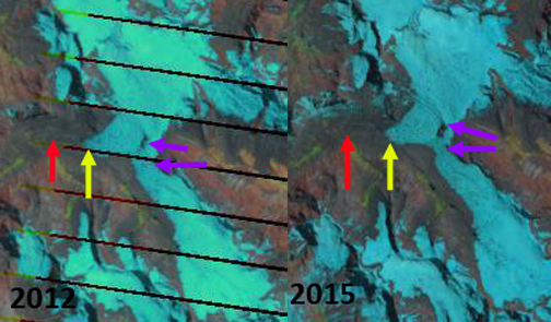
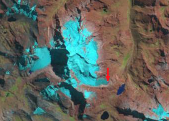
Landsat comparison from 2012 and 2015 of Nevado Soral Glaciers, Bolivia.  Red arrow is the 1988 terminus, yellow arrow the 2016 terminus and the purple arrow areas of rock expansion indicating upglacier thinning.

laguna suches

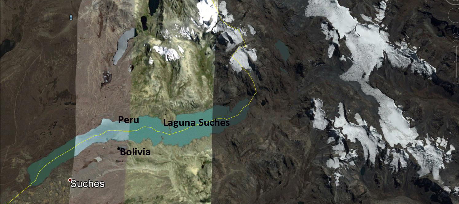
Nevado Soral Glacier drains into Laguna Suches.

Chaupi Orko Glaciers, Bolivia Extensive Recession

chaupi orko compare

Landsat comparison of the Chaupi Orko Glaciers from 1988, 1999 and 2015.  Red arrows indicate 1988 terminus and yellow arrows the 2015 terminus location.

Chaupi Orko is a 6044 m Andean peak in the Cordillera Apolobamba on the Peru-Bolivia border with glaciers radiating from it summit.  Here we examine a pair of glaciers on the southern side of the mountain that drain into Laguna Suches, which is split by the Bolivia-Peru border. Laguna Suches is most known for placer gold mining. Glaciers in Bolivia have been experiencing substantial retreat during the last 40 years, such as at Nevada Cololo. The glaciers of the Apolobamba have lost 48% of their area from 1975-2006 (Hoffmann, 2012). Hoffmann and Weggenmann (2012) observed both the extensive retreat, new lake formation, and the potential problem of glacier lake outbursts in this region, which is part of the Apolobamba Integrated Natural Management Area. In a continuation of these studies an excellent study in review by Cook et al (2016) indicates a 43% decline in glacier area in the Cordillera Apolobamba from 1986 to 2014. They identified a total of 25 lakes with some risk of GLOF, though historic occurrences to date in the area are few. They further found an decrease in proglacial lakes in contact with glaciers during this period. The glaciers here are summer accumulation type with the ablation occurring during the dry season from May-October .

In 1988 the southwest Chaupi Orko Glacier (W), red arrow, does not have a proglacial lake at its terminus. The southern Chuapi Orko Glacier (S) ends adjacent to a small lake east of the terminus, red arrow. By 1999 a small proglacial lake has formed at the terminus of the southwest Chaupi Orko Glacier. The southern Chaupi Orko Glacier has receded 350 m. By 2015 the southwest Chaupi Orko Glacier (W) has retreated to the yellow arrow, with the proglacial lake having expanded to an area of 0.35-0.4 square kilometers. Retreat of the west glacier has ranged from 500 to 800 m. The southern Chaupi Orko Glacier has retreated 600 m exposing two new small proglacial lakes that it has since largely retreated from. The lakes are narrow and too small to be a Glacier lake outburst flood (GLOF) threat. This particular basin does not pose a GLOF threat with no substantial lake below the south glacier and only the small, apparently shallow lake below the west glacier.   A small island in the midst of the lake, suggests lake not very deep. The west glacier has a calving face enhancing retreat (IC).Neither glacier indicates significant thinning higher on the glacier, suggests limited melting.  This is a region of significant ablation via sublimation vs melting, which is not as efficient a process for mass loss and is enhanced during La Nina periods (Vuille et al, 2008). The reduction of glacier area does lead to declines in glacier runoff, which will have a more widespread impact.

chaupi orko esri

Small island amidst proglacial lake from the west glacier, also ice cliff noted.
Apolobamba ge

Google Earth image of the Chaupi Orco region.

Zongo Glacier Retreat, Bolivia 1994-2014.

Zongo Glacier, Bolivia extends 2.9 km down the south side of Huayna Potosi from 6000 m to 4900 m. Zongo Glacier is a small valley glacier located 30 km north-east of La Paz, and its runoff is directed to an important hydraulic power station which supplies La Paz. Note Laguna Milluni in foreground of the first image. The dam is visible as is the power station to the right and below the lake. The glacier has considerable snowcover on its upper section and crevassing. This indicates a persistent accumulation zone. In 1991 a glaciological research program was established on Zongo Glacier to monitor mass balance, understand its hydrology and energy balance. The long term director of this research Bernard Francou has been called the glacier guardian. The cumlative mass balance of the glacier from 1991-2013 has been -6.5 m water equivalent. The typical Alpine glaciers undergoes a long accumulation period in winter and a short ablation season in summer. The glaciers of the tropical Andes experience snow accumulation during the wet season, austral summer on their upper regions and maximum ablation during the same season low on the glacier. In the dry season winter there is a period of low ablation over the whole glacier. Mean annual air temperature at the long term snowline at 5250 m is -1.5 °C. Mean precipitation is about 0.9 m/year. zongo laguna
Google Earth image-Huayna Potosi and Zongo Glacier

Since 1991 the glacier has lost more than 7 m of thickness and has retreated significantly. The mass balance loss has been most pronounced during El Nino periods. La Nina’s are associated with positive or only slightly negative mass balance. Here we examine Landsat imagery and Google Earth imagery form 1994 to 2014.

In 1994 there is no lake at the terminus of the glacier, red arrow. By 2004 the Google Earth image indicates the glacier terminating along the northeast shore of the lake, a 90 m retreat in a decade. By 2008 the glacier no longer reaches the edge of the lake, but the front is still crevassed. In 2014 the glacier terminates 100 meters from the lake. Total retreat during the 20 year period is 220 m. The current terminus in 2014 is dirtier and less crevassed than in 2004, and less crevassed than in 2008. The lower 200 m of the glacier is thin, narrow and lacks active crevassing. This relatively stagnant area will melt away in the next decade.

Zongo Glacier continues to have an accumulation zone, a necessary essential for glacier survival, and unlike the nearby Chacaltaya Glacier which disappeared in 2009, it will exist for sometime. The Chacaltaya Glacier is a small glacier, like 80% of the glaciers in this region of the Cordillera Real, and its disappearance puts more pressure on the water resources provided by the larger remaining glaciers such as Zongo Glacier. Rabatel et al (2013) note the striking rise in the freezing levels in the region due both to higher temperatures and more convective activity that is a particular threat to glacier survival.

zongo ls 1994
1994 Landsat image

zongo 2004
2004 Google Earth image

zongo 2008
2008 Google earth image

zongo 2014
2014 Google Earth image

zongo ls 2014
2014 Landsat image