Roosevelt Glacier Retreat, Mount Baker, Washington

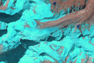
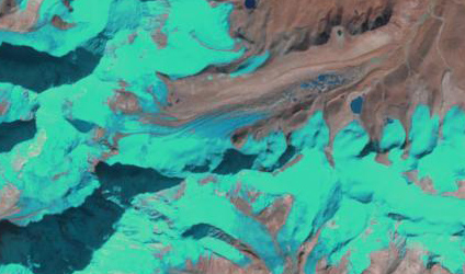
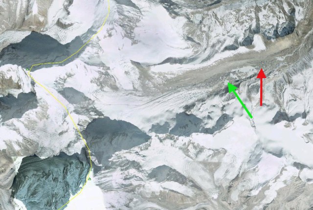
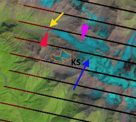
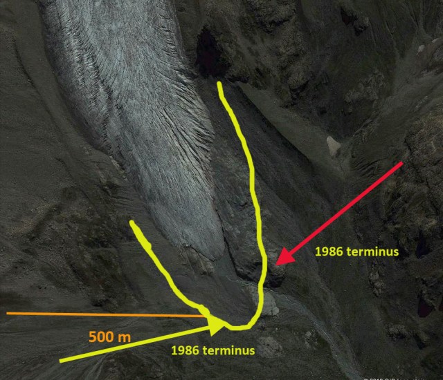
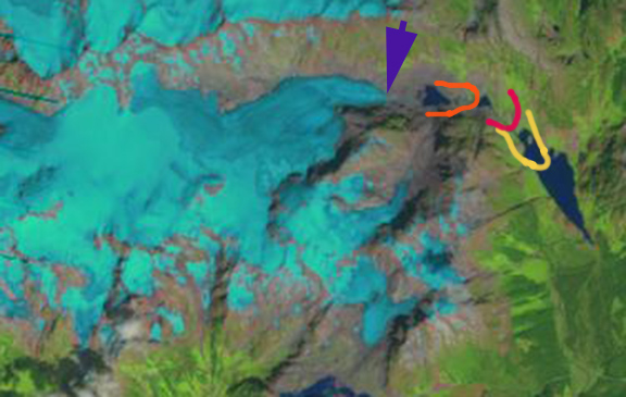
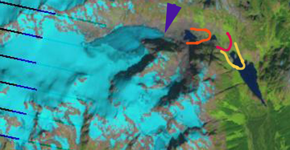
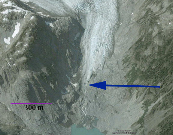
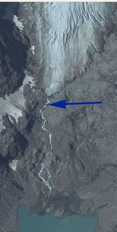
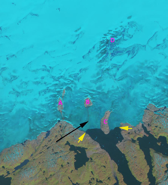
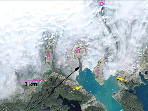
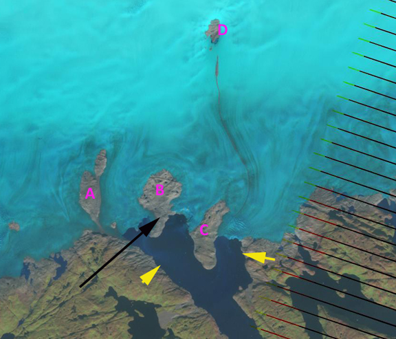
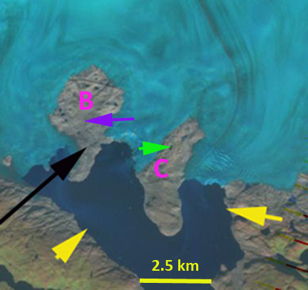
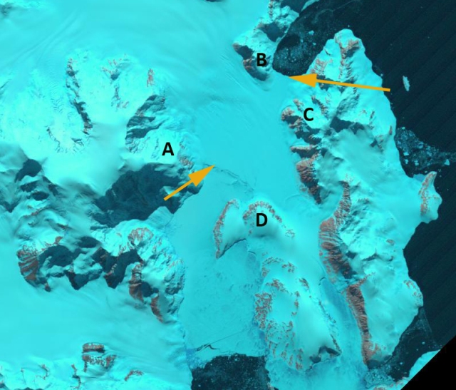
Roosevelt Glacier is on the northwest side of Mount Baker, Washington with its accumulation zone joined with the Coleman Glacier. My first visit to Roosevelt Glacier was in 1984, when the glacier had just completed a 30 year period of advance from 1949-1979.  Since 1979 the glacier has been retreating, image below. roosevelt 79This post examines Google Earth imagery from 1993, 2003 and 2009 along with field observations from the glacier. The purple line indicates the advance moraine that the glacier emplaced during the 1949-1979 period of advance. We mapped the location of this moraine in 1985, when it was still recent and very evident. The red line is from 1993, yellow line from 2003 and green line from 2009. In 1993 the area below the lip of lava flow cliff is thin and stagnant, cliff noted by purple arrow. By 2003 the glacier has retreated to the top of the cliff and by 2009 the glacier has pulled back from the edge of the cliff. By 2012 the lower glacier, viewed from the edge of the Coleman Glacier, is thin and uncrevassed in the lower 350 meters of the glacier, up to the red arrow. The glacier retreated 190 meters from 1979 to 1993 and 220 meters from 1993 to 2009. The rate of 14 m/year has been relatively consistent.roosevelt terminus 1993

roosevelt terminus 2003

roosevelt terminus 2009

roosevelt 2012
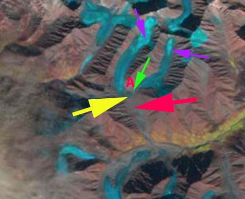
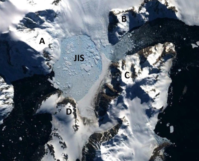
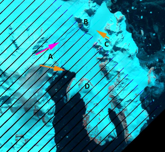
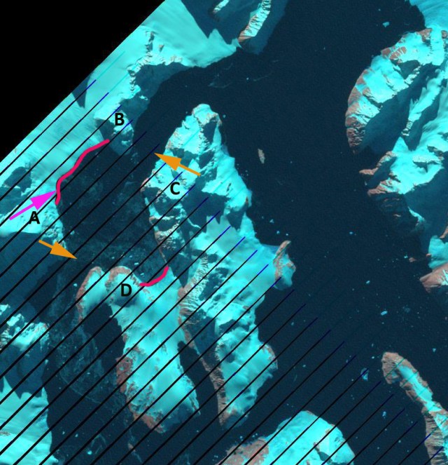
The glacier is fed by three principal accumulation zones: 1) A glacier tongue that descends from the summit plateau at 3200 meters, 2) an avalanche fed and direct snowfall region beneath the north ridge, at 2200 meters 3) an avalanche and direct snowfall fed region beneath the northwest face, at 2400 meters. The annual snowline has averaged 2150 meters on Roosevelt Glacier from 1984-2010, which has led to a similar retreat of 14 m/year and mass balance loss -0.52 m/year of all Mount Baker glaciers, Pelto and Brown (2012). Each summer we investigate the retained snow depth retained in the crevasse stratified exposures on Mount Baker in the 2400 meter range. Below are several images from this investigation. In the second image the magenta arrows indicate specific annual layers that have been retained. Typical thicknesses are 1.75 to 2.25 m. The next two images are from when we are in an icefall looking for the best exposure to measure the annual layer stratigraphic thickness. The behavior of this glacier parallels that of Deming Glacier, Boulder Glacier and Rainbow Glacier all on Mount Baker. roosevelt profile

crevasse roosevelticefall strat

icefall strat2

December 2012 Glacier Post Index

Below is a list of the individual glacier posts examining our warming climates impact on each glacier. This represents the first 3.4 years of posts, 262 total posts, 240 different glaciers. I have worked directly on 46. The others are prompted by fine research that I had come across, cited in each post or inquiries from readers and other scientists. I then look at additional often more recent imagery to expand on that research. The imagery comes either from MODIS, Landsat, Geoeye or Google Earth. There is a consistent signal from the glaciers, mass balance loss, thinning and retreat. In many cases this leads to new lake formation or lake expansion for alpine glaciers. I will continue to record these changes here with a new post twice a week and in the field.


United States
Columbia Glacier, Washington
Lyman Glacier, Washington
Boulder Glacier, Washington
Deming Glacier Icefall, Washington
Deming Glacier, Washington
Easton Glacier Assessment, Washington
Mount Baker Mass balance, Washington
Ptarmigan Ridge Glacier, Washington
Dusty Glacier, Washington
Anderson Glacier, Washington
Eel Glacier, Washington
Milk Lake Glacier, Washington
Suiattle Glacier, Washington
Paradise Glacier, Washington
Easton Glacier, Washington
Redoubt Glacier, Washington
Honeycomb Glacier, Washington
Vista Glacier, Washington
Rainbow Glacier, Washington
Daniels Glacier, Washington
Colonial Glacier, Washington
Quien Sabe Glacier, Washington
Mazama Glacier
Fairchild Glacier, Washington
White Glacier, Washington
Banded Glacier, Washington
Borealis Glacier, Washington
Hinman Glacier, Washington
Lower Curtis Glacier, Washington
Mount Baker Glaciers, Washington
McAllister Glacier, Washington
Lewis Glacier, Washington
Kennedy Glacier, Washington
Fremont Glacier, Wyoming
Minor Glacier, Wyoming
Knife Point Glacier, Wyoming
Bastion Glacier, Wyoming
Sourdough Glacier, Wyoming
Grasshopper Glacier, Wyoming
Grasshopper Glacier, Montana
Harrison Glacier, Montana
McDonald Glacier, Montana
Sperry Glacier, Montana
Hopper Glacier, Montana
Old Sun Glacier, Montana
Yakutat Glacier, Alaska
Grand Plateau Glacier, Alaska
Eagle Glacier, Alaska
Gilkey Glacier, Alaska
Fork Glacier, Alaska
Gilkey Glacier ogives, Alaska
Lemon Creek Glacier, Alaska
Taku Glacier, Alaska
Bear Lake Glacier, Alaska
Chickamin Glacier, Alaska
Okpilak Glacier, Alaska
Sawyer Glacier, Alaska
Valdez Glacier, Alaska
Antler Glacier, Alaska
Field Glacier
East Taklanika Glacier, Alaska
Brady Glacier, Alaska
Brady Glacier Retreat lake expansion 2004-2010, Alaska
Thiel Glacier, Alaska
Speel Glacier, Alaska
Romanzof Glacier, Alaska
Pedersen Glacier, Alaska

Canada
Icemantle Glacier, BC
Bridge Glacier, British Columbia
Stave Glacier, British Columbia
Washmawapta Glacier, British Columbia
Bubagoo Glacier, British Columbia
Hector Glacier, Alberta
Helm Glacier, British Columbia
Jacobsen Glacier, British Columbia
Melbern Glacier
Warren Glacier, British Columbia
Castle Creek Glacier, British Columbia
Hoboe Glacier, British Columbia
Coleman Glacier, British Columbia
Tulsequah Glacier, British Columbia
Des Poilus Glacier, British Columbia
Decker and Spearhead Glacier, British Columbia
Columbia Glacier, British Columbia
Freshfield Glacier, British Columbia
Apex Glacier, British Columbia
Great Glacier, British Columbia
Devon Ice Cap, Nunavut
Penny ice Cap, Nunavut
Northern Outlet Devon Ice Cap, Nunavut
Penny Ice Cap SW, Nunavut
Mittie Glacier, Ellesmere Island, Nunavut
Snowshoe Peak, Yukon
Petain Glacier, Alberta

Himalaya
Ngozumpa Glacier, Nepal
West Barun Glacier, Nepal
Khumbu Glacier, Nepal
Imja Glacier, Nepal
Reqiang Glacier Retreat, Nepal
Kali Gandaki Headwaters, Nepal
Samudra Tupa, India
Malana Glacier, India
Sara Umaga Glacier, India
Zemu Glacier, Sikkim
North Lhonak Glacier, Sikkim
Changsang Glacier, Sikkim
Gangotri Glacier, India
Milam Glacier, India
Satopanth Glacier, India
Theri Kang Glacier, Bhutan
Zemestan Glacier, Afghanistan
Emend River Headwaters, Afghanistan
Yajun Peak Glacier, Afghanistan
Godur Glaicer, Pakistan
Tirich Mir, Pakistan
Longbasba Glacier, Tibet
Menlung Glacier, Tibet
Boshula Glaciers, Tibet
Urumquihe Glacier, Tibet
Lumding Glacier, Tibet
Matsang Tsanpo Glacier, Tibet
Dzhungharia Alatau, Kazakhstan
Petrov Glacier,Kyrgyzstan
Hailuogou Glacier, China
Himalaya Glacier Index

Europe
Taconnaz GLacier, France
Mer de Glace, France
Dargentiere Glacier, France
Grand Motte and Pramort Glacier Tignes Ski area, France
Saint Sorlin, France
Sommelier Glacier, France
Obeeraar Glacier, Austria
Rotmoosferner, Austria
Stubai Glacier, Austria
Hallstatter Glacier, Austria
Ochsentaler Glacier, Austria
Pitzal Glacier, Austria
Dosde Glacier, Italy
Presena Glacier, Italy
Forni Glacier, Italy
Careser Glacier, Italy
Lobbia Glacier, Italy
Sabbione Glacier Retreat, Italy
Triftgletscher, Switzerland
Gietro Glacier, Switzerland
Ried Glacier, Switzerland
Cavagnoli Glacier, Switzerland
Chuebodengletscher and Ghiacciaio-del-Pizzo-Rotondo, Switzerland
Peridido Glacier, Spain
Maladeta Glacier, Spain
Engabreen, Norway
Midtdalsbreen, Norway
Tunsbergdalsbreen, Norway
Lodalsbreen, Norway
Rembesdalsskaka, Norway
TungnaarJokull, Iceland
Langjökull, Iceland
Gigjokull, Iceland
Porisjokull, Iceland
Skeidararjokull, Iceland
Kotlujokull, Iceland
Lednik Fytnargin, Russia
Kirtisho Glacier, Georgia
Lednik Kauraugom, Russia
Irik Glacier, Mount Elbrus, Russia

Greenland and European Arctic
Mittivakkat Glacier
Ryder Glacier
Humboldt Glacier
Petermann Glacier
Kuussuup Sermia
Thrym Glacier Retreat
Tiningnilik Glacier Lake
Jakobshavn Isbrae
Zachariae Isstrom
Umiamako Glacier
Alison Gletscher
Kong Oscar Glacier
De Reste Bugt
Qaleraliq Glacier
Upernavik Glacier
Apuserajik Glacier
Epiq Sermia
Sarqardliup Seremia
Steensby Glacier
Sortebrae Glacier, Greenland
Severnaya Zemlya, Russian Arctic
Hansbreen, Svalbard
Nannbreen, Svalbard
Hornbreen and Hambergbreen, Svalbard
Olsokbreen, Svalbard
Albrechtbreen, Svalbard
Roze and Sredniy Glacier, Novaya Zemyla
Nizkiy and Glazova Glacier, Novaya Zemyla

South America
Colonia Glacier, Chile
Artesonraju Glacier, Peru
Nef Glacier, Chile
Tyndall Glacier, Chile
Alemania Glacier, Chile
Zongo Glacier, Bolivia
Sierra Nevade del Cocuy Glaciers, Colombia
Ritacuba Blanco Glacier, Colombia
Llaca Glacier, Peru
Joerg Montt Glacier, Chile
Nororeste Glacier, Chile
Arhuey Glacier, Peru
Seco Glacier, Argentina
Onelli Glacier, Argentina
Quelccaya Ice Cap, Peru
Manon Glacier, Peru
Chuecon Glacier
Glacier Gualas, Chile

Antarctica and Circum Antarctic Islands
Pine Island Glacier
Fleming Glacier
Hariot Glacier
Smith Glacier, Antarctica
Thwaites Glacier, Antarctica
Amsler Island
Stephenson Glacier, Heard Island
Neumayer, South Georgia
Ampere, Kerguelen
Lapparent Outlet, Kerguelen Island
Cook Ice Cap, Kerguelen Island
Nordenskjold Coast, Antarctic Peninsula
Prospect Glacier, Antarctic Peninsula
Ross Hindle Glacier, South Georgia
Vega Island Ice Cap
Rohss Bay, James Ross Island, Antarctica
Jones Ice Shelf, Antarctica

New Zealand
Tasman Glacier
Murchison Glacier
Donne Glacier
Mueller Glacier, NZ
Gunn Glacier, NZ
Douglas Glacier Neve, NZ

Africa
Rwenzori Glaciers
Tyndall Glacier, Kenya

North Cascade Glacier Climate Project Reports

Forecasting Glacier Survival
North Cascade Glacier Mass Balance 2010
Columbia Glacier Annual Time Lapse
North Cascade Glacier Climate Project 2009 field season
28th Field Season Schedule of the North Cascade Glacier Climate Project
North Cascade Glacier Climate Project 2011 Field Season
BAMS 2010 alpine glaciers
BAMS 2011 Alpine Glaciers
2011 Glacier mass balance North Cascades and Juneau Icefield
Taku Glacier TSL Paper
Glacier Ground Truth 2012 North Cascade Field Season
North Cascade Glacier Climate Project 2012 Field Season

Changsang Glacier Retreat and Lake Formation, Sikkim

Changsang Glacier is a valley glacier just north of Kanchengjunga, the third highest peak, in Sikkim. A comparison of Landsat imagery from 1989 to 2012 identifies the formation of a lake at the end of the glacier. The red arrow indicates the downvalley end of the lake that will develop, the green arrow the upvalley end. In 1989 there is no evidence of a lake either on top of the glacier, supraglacial or proglacial, at the end of the glacier. In 2000 there are a several small lakes beginning to develop. In the 2006 Google Earth imagery the lake is 700 meters long with several other developing smaller lakes. By 2011 the main lake is 1000 meters long and has one debris covered ridge that separates it from a second lake. By 2012 the lake has expanded incorporated the second lake and is now 1500 meters long. The Changsang Glacier was reported to be retreating 22 m/year from 1976 to 2005 (Raina, 2009). In Sikkim 26 glaciers examined were retreating at an average rate of 13.02 m per year from 1976 to 2005 (Raina, 2009) is following the same path as South Lhonak Glacier just to the north and Zemu Glacier just to the south. Zemu Glacier to the south is fed by a higher accumulation zone, and has not been retreating as fast, but it should be anticipated that a lake will form near its terminus.

changsang1989
changsang 2000

changsang 2006 ge

changsang 2011
changsang 2012

A closeup view of the terminus area in 2006 indicates the main lake and several smaller lakes that will join the main lake by 2012. The purple arrow indicates the outlet river from beneath stagnant debris covered ice. The orange arrows indicate the extent of the developing lake by 2012.
changsang terminus

Kirtisho Glacier Retreat, Georgia

The southern flank of the Caucasus Mountains is in the nation of Georgia. Ten kilometers southwest of the Lednik Karaugom Glacier, Russia from the previous post is Kirtisho Glacier a 4.5 km long valley glacier, a small subglacier KS is also examined in this post.caucasus submap The glaciers in the Causcasus Mountains have been undergoing a significant retreat, the USGS, (2010) Satellite Image Atlas of Asia, noted that nearly all of the 65 glaciers examined in this region experienced significant retreat from 1987-2004. Shahgedanova et al, (2009) noted a 8 meters per year average retreat rate for the 1985-2000 period. To get a feel for the terrain watch the trailer for the On the Trails of the Glaciers- Caucasus 2011. The video does not show Kirtisho Glacier but does indicate the nature of the terrain. This is a project of an Italian group Macromicro, that had contacted me about an upcoming expedition to Alaska in 2013. Landsat images from 1986 (second image) and 2012 (third image) along with 2011 Google Earth imagery (top and bottom image) are shown below. Kirtisho Glacier has a top elevation of 3700 meters and a terminus that in 2012 is at 2600 meters, and was 2400 m in 1986. The snowline has typically been at 3300 meters, blue arrow, which is too high to sustain the terminus at 2600 m. The terminus position in 1986 is indicated by a red and yellow arrow that are also used in the 2012 imagery and the 2011 terminus closeup. The magenta arrow in the Landsat images indicates the beginning of a separation from an northern tributary, which is close to the snowline. The terminus itself is not crevassed in the lowest 400 meters, suggesting retreat will continue for this nearly stagnant section. KS the small glacier to the south, has decreased in area from 0.45 km2 in 1986 to 0.20 km2 in 2012. We also examine this more below. kirtisho glacier profile

kirtisho 1986Kirtisho 2012

kirtisho terminus The KS glacier viewed up close is quite thin, with limited crevasses. The red arrows indicate rock protruding through this glacier in many locations. These rocks indicate how thin the ice is, and will help absorb heat and hasten melting as the rock outcrops expand. In 2011 and in the 2012 imagery there is no remaining snow on the glacier. A glacier without a persistent accumulation zone cannot survive (Pelto, 2010). KS glacier will not survive much longer. ks 2011

Lednik Karaugom Glacier Retreat Caucasus Mountains, Russia

Lednik Karaugom Glacier is a large 13 km long, valley glacier in the Caucasus Mountains of Northern Ossetia, Russia. The glacier drains into the Urukh River which joins the Terek River and then flows into the Caspian Sea. This post compares Landsat imagery from 1986, 2010 and 2012, an image from the USGS in 2002 and Google Earth imagery from 2009. This glacier has experienced a general retreat like all the glacier draining north from the Caucasus Mountains. USGS, (2010) Satellite Image Atlas of Asia, noted that nearly all of the 65 glaciers examined in this region experienced significant retreat from 1987-2004, noting a retreat of Karaugom of 600 m. Maria Shahgedanova, has an ongoing project examining Caucasus glaciers. Shahgedanova et al, (2009) noted a 8 meters per year average retreat rate for the 1985-2000 period. The glacier retreat has led to an increase in debris cover and an increase in the number of proglacial and supraglacial lakes. (Stokes et al , 2007) This glacier begins at the Russia-Georgia border and extends up to the base of Gora Uilpata at 4200 meters. There is a substantial icefall separating the accumulation zone above 3500 meters from the ablation zone of the valley tongue beginning at 2500 m.karpovareafrom 1987-2002. In the series of images below the yellow arrow indicates the 1986 terminus position, the pink arrow the 2012 terminus position, the orange arrow the 2002 terminus position and the blue arrow the former connection with a tributary. The retreat from 1986 to 2012 is 1300 meters, about 50 meters/year. The retreat of the tributary from the main glacier has been 200 meters, or 8 meters/year. karaugom glacier 2002
karaugom glacier 1986
karaugom glacier 2010
karaugom Glacier 2012
A closeup of the terminus indicates the amount of debris cover, and the formation of ogives at the base of the icefall. The lateral moraine marking the previous ice surface elevation is also noted with a green arrow. This glacier remains vigorous in its flow, with substantial crevassing and ongoing crevasse formation. The retreat is ongoing but the end of the glacier is not stagnant, though the lower 300 meters has reduced crevassing and width. The degree of crevassing at the green arrows at a small icefall 300 meters above the terminus indicates both ice thickness and flow and suggest that the retreat will likely be reduced in the near future. The behavior is similar to that of Lednik Fytnargin and Irik Glacier on Mount Elbrus karaugom icefall

Stave Glacier Retreat, British Columbia

Stave Glacier is a six kilometer long valley glacier in Garibaldi Provinical Park, British Columbia. Koch et al (2009) in their detailed survey of glaciers in the park chronicled the glacier’s retreat from 1952 to 1996. Here we update the changes in Stave Glacier to 2012. Koch et al (2009) completed a map, first image that indicates the retreat rate of the glacier as 26 meters/year from 1900-1952, 33 meters/year 1952-1977 and 53 meters/year from 1977 to 1996. Examined below is Google Earth imagery from 2006, aerial photography from 2009 and Landsat imagery from 2009 and 2012. The Google Earth image indicates the terminus position using arrows in 1952 (yellow arrow), 1977 (pink arrow), 1996 (orange arrow), 2006 (blue arrow) and 2012 (purple arrow). In the Landsat images the same color scheme is used, for terminus front lines also. The retreat from 1996-2012 is 1600 meters, 100 meters/year. This glacier is still not approaching equilibrium as the accelerating retreat indicates. stave mapstave ge
stave 2009
stave 2012 A close up of the terminus in 2006 (top) and 2009 (bottom) indicates the lowest couple hundred meters is thin and uncrevassed indicating retreat will continue. The glacier terminus is at 1275 meters today. There is an active icefall above the terminus at 1500 meters, the snowline has been at 1900 meters. Unlike the nearby Helm Glacier, Stave Glacier has a persistent accumulation zone and can survive current climate. Its behavior is similar to that of Warren Glacier. stave 2006 terminusstave terminus

Qaleraliq Glacier Retreat, Southern Greenland

Qaleraliq Glacier is in southern Greenland and flows into the Tasermiut Fjord. Glaciers in this region have experienced substantial retreat since 1990 Weidick et al (2012) and Howat and Eddy (2011). Howat and Eddy (2011) state that, “We find that 90% of the observed glaciers retreated between 2000 and 2010, with rapid retreat observed in all sectors of the ice sheet. The current retreat is accelerating and likely began between 1992 and 2000, coincident with the onset of warming, following glacier stability and minor advance during a mid-century cooling period.” In this case we are examining a tidewater glacier in Southern Greenland using satellite imagery from 1992, 2004, 2010 and 2012. In each image locations A-D are in the same locations marking specific bedrock islands (nunataks) within the ice sheet. The yellows arrows indicate the 1992 terminus position in each image, the black arrow denotes the terrain south of bedrock nunatak B. Retreat of the west arm of the glacier has been 3.2 km from 1992 to 2012. The east arm retreat in the last twenty years has been 1.2 km. In 1992 Nunatak A is 1.5 km from the ice edge and is composed of two separate nunataks. By 2010 the two nunataks have merged and by 2012 Nunatak A is 1 kilometer from the ice edge. In 1992 Nunatak B is 3 km from the icefront surrounded by the ice sheet and in 2012 the nunatak has increased in size and extends 1 km beyond the terminus. Nunatak C has largely emerged from the ice sheet, the nunatak has also expanded in length by 500 meters as ice has thinned during the retreat. The Nunatak at D did not exist in 1992, but by 2012 it is over 1 km long.
qaleraliq 1992
qalaeriq ge
qaleraliq 2010
qaleraliq 2012
A close up view of the terminus and Nunatak B and C from 1992 and 2012 illustrates the expansion of the nunataks as ice has thinned. The locations at the green and purple arrows are the same in both images. In 1992 these locations are near the nunatak margin and by 2012 the locations are in the midst of the Nunatak. Qaleraliq Glacier behavior is similar to that of almost all southern Greenland glaciers, most of which like Qaleraliq have not been the focus of detailed study, such as Kuussuup Sermia, Narssap Sermia or Kangiata Sermia. In the Tasermiut Fjord Biggs (2011) noted the retreat of two glaciers Sermitsiaq and Itillersuaq that have each retreated 600 and 300 m respectively from 1987 to 2009.qualeraliq glacier 1992The unusual nature of the 2012 melt season can be seen in this animated graph of ice sheet melt extent with data from Marco Tedesco, Figure 2a in the recent paper submitted (Tedesco et al, 2012).

qualeraliq glacier 2012

Fork Glacier Retreat and Separation, Brooks Range, Alaska

The Romanzof Mountains in the Brooks Range of Alaska has numerous small alpine glaciers. This is an area that has seen some of the greatest warming of anywhere over the last 30 years. In this post we focus on Fork Glacier which is just northwest of Okpilak Glacier. The glaciers in this region have been undergoing significant thinning and mass loss (Delcourt et al, 2008) including on McCall Glacier, Okpilak Glacier and Romanzof Glacier. Here we examine the changes in Fork Glacier, that has an 2.5 km long east and 3.5 km long west arm that joined at 1800 meters. The glacier than descends 600 meters to a terminus at 1700 m in 1982, the western arm is longer, wider and begins higher at 2300 meters. The first image is a 1982 aerial photograph from the USGS, followed by a 2000 Landsat image, 2009 Google Earth and 2012 Landsat image. The Pink A indicates where the two arms of the glacier joined, the pink arrows indicate the 1982 terminus and the yellow arrow the 2009 terminus. The glacier remained joined in 2000, but for a shorter distance than in 1982. By 2009 the glacier had retreated 400 meters from 1982 and has separated at the terminus. By 2012 the eastern terminus has separated by 200 m from the west branch, green arrow. The other problem evident in the 2012 satellite imagery is the limited extent of snowpack on the glacier at the purple arrows. This level of snowpack even with a month left in the accumulation season indicates a glacier without a consistent accumulation zone that cannot survive (Pelto, 2010) fork 1982fork2000fork gefork2012214 A close up view of the terminus from the 2009 Google Earth imagery indicates the retreat but also the green arrow highlights a supraglacial stream that indicates stagnant ice on the eastern arm of the glacier. fork2012214

Jones Ice Shelf Loss, Antarctica

The Jones Ice Shelf was midway up the west coast of the Antarctic Peninsula. The ice shelf (red arrow) was smaller than other ice shelves that have mostly or substantially disintegrated Wordie Ice Shelf (orange arrow), Larsen B Ice Shelf (pink arrow) or Wilkins Ice Shelf (green arrow). Ant-pen_mapThe British Antarctic Survey (BAS), has been observing the changes in ice shelves around the Peninsula Cook and Vaughan, (2010) and Fox and Vaughan (2005). The BAS noted that the ice shelf had an area of 29 square kilometers in 1980, by 1990 21 square kilometers and 10 square kilometers in 2000 and 2003, gone. Blaicklock Island (C and D) and the Arrowsmith Peninsula (A and B) are now separated by open water in Jones Channel. Cook and Vaughan (2010) also note that this was not the result of a long ongoing retreat, the Jones Ice Shelf expanded 20 % between 1947 and 1978. In the post below there is a sequence of images from Landsat and Google Earth imagery in a sequence as follows, 1989, 1991, 1999, 2009 and 2011. The Ice shelf exists in 1989 and 1991, ending at the orange arrows, which are included in the 2009 and 2011 images as well for comparison. Points A-D are in the same location in each image. The 1999 image indicates a disintegrating Jones Ice Shelf (JIS), with a small ice tongue protruding part way across Jones Sound, the new waterway that has opened. By 2009 the glacier has retreated out of the Jones Channel to the pink arrow and red line in 2011. The eastern terminus retreated 4 km and the western terminus 7 km. The ice shelf loss here is similar in magnitude to Rohss Bay on James Ross Island. jones 1989jones 1991jones tongue gejones 2009jones 2011

Dusty Glacier, Glacier Peak, WA

In the 1990’s the North Cascade Glacier Climate Project undertook a study of all the glaciers around Glacier Peak, one century after they had been first observed by C.E. Rusk. This post focuses on one of those glaciers, Dusty Glacier on the Northeast side of the peak.

In 1940 J.B. Richardson of the Forest Service photographed many North Cascade glaciers surrounding Glacier Peak. From 1946-1958 William Long, of the Forest Service surveyed many glaciers throughout the North Cascades (Long, 1955). From 1950-1955 Richard Hubley, University of Washington, completed the first aerial glacier surveys of North Cascade termini, noting the beginning of an advance on many (Hubley, 1956). The USGS in 1960 began an annual aerial photographic survey of North Cascade glaciers that continued up through 1979. In 1984 the North Cascade Glacier Climate Project began annual terminus observations on 47 glaciers and mass balance measurements on ten of these (Pelto, 1996). The average retreat of Glacier Peak glaciers from the LIA to the 1958 positions was 1640 m. Richard Hubley noted that on Glacier Peak glaciers began to advance in the early 1950s, after 30 years of rapid retreat. The advance was in response to a sharp rise in winter precipitation and a decline in summer temperature beginning in 1944 (Hubley, 1956; Long, 1955 and 1956). Ten of the fifteen glaciers around Glacier Peak advanced, including all of the glaciers directly on the mountains slopes. Advances of Glacier Peak glaciers ranged from 15 to 480 m and culminated in 1978. All 11 Glacier Peak glaciers that advanced during the 1950-1979 period emplaced identifiable maximum advance terminal moraines. By 1984, all the Glacier Peak glaciers were again retreating. This retreat has been monitored by NCGCP. Two of the glaciers including Milk Lake Glacier and North Branch Whitechuck Glacier have disappeared.
The depth of snowpack even in Mid-August near the top of the Dusty Glacier is what drives the rapid movement and crevassing of the glacier. In the first image below the red arrow indicates the annual layer, which was 5.7 m thick in 1997. Thew second image has me standing at the terminus in 1994, which was still active even though it was retreating.

Dusty Glacier has the widest most fearsome crevasses of any glacier in the North Cascades. The glacier descends from 2750 m to 2560 m before plunging over an icefall. The glacier levels out in a basin at 2325 m, before descending a second icefall to its current terminus at 1960 m. Dusty Glacier joined with the North Guardian Glacier during the LIA, separating during the 1930’s. During the LIA the glacier advanced to 1465 m. The retreat of this glacier by 1906 when Rusk observed it had been only 400 m. The glacier ended in a basin that was filled with ice, though much of the ice was stagnant. This basin became known as Recession Basin, for the ensuing rapid retreat up until 1946 when the glacier had retreated out of the basin and ended just north of Recession Rock (R) at 2020 m. By 1955 advance was underway, an advance of 130 m had already occurred (Hubley, 1956). The advance ceased until 1967 when it began again, the glacier reaching another 150 m down into the upper part of Recession Basin at 1865 m. The terminus today is very active with extensive crevassing. In fact it is a true icefall. The glacier retreated 220 meters from its 1970’s advance moraine by 1994 during our first visit, 260 m by 1997-1998 at the time of our second visit and 400 meters by 2006 in the Google Earth imagery. The glacier remains quite crevassed though not nearly as much as in 1955. Below the first image is from 1955 taken by Richard Hubley, the second is in 2004, third in 2006 and last in 2008. In each image Recession Rock is labelled with a purple R, the maximum advance of the 1955-1970’s indicated by a orange arrow and the crevassed top of the lower icefall by a green arrow.

Google Earth images from 1998 and 2006 illustrate the retreat over the last 35 years. This glacier has not lost as much area as others around Glacier Peak, such as Milk Lake Glacier which disappeared, Honeycomb Glacier or Vista Glacier. The area loss has been more modest like on Suiattle and Kennedy Glacier.

Lodalsbreen Retreat, Norway

Lodalsbreen is an outlet glacier from the northeast region of the Jostedalsbreen Icecap of Norway. This particular outlet is difficult to reach and not often investigated, for this icecap in general all 10 glaciers observed from 2000-2010 have retreated (Norwegian Water Resources, 2010). Recent work by Nussbaumer et al (2011) and Imhof et al (2011) have focussed on the changes in terminus postion of Jostedalsbreen glaciers since the Little Ice Age including Lodalsbreen. The glacier reached a maximum around 1750 and has retreated 4.5 km up to 2006 as noted in the second image below modified only slightly from Nussbaumer et al (2011). The third image indicates Lodalsbreen and the western tributary and the large accumulation zone of Jostedsalsbreen that feeds the many outlet glaciers, image source is the WGMS-UN publication Global Glacier Change:s Facts and Figures. The glacier was 6 km long in 2005. A comparison of 1989, 2000, 2002, 2010 and 2012 Landsat imagery indicates the retreat of the main tongue, purple arrow for 1989 and yellow arrow 2010 and western tributary that was previously joined to the glacier, red arrow at 1989 terminus. From 1989 to 2010 Lodalsbreen has retreated 240 meters. The western tributary terminated in the valley bottom at 750 meters above sea level in 1989, and by 2010 has retreated 500 meters up the valley wall to 1000 meters above sea level. Most of the retreat of the tributary has been since 2000. The retreat of this glacier is similar to that of other Norwegian glaciers in the area, Tunsbergdalsbreen and Midtdalsbreen . The Jostedalsbreen has a large accumulation area above 1500 meters that feeds the many outlet glaciers, which are no in danger of disappearing with current climate.

Douglas Neve Glacier Retreat, New Zealand

The primary portion of the Douglas Glacier was a debris covered valley tongue that is separated from the slopes feeding the terminus reach. The feeder glacier tongues, pink arrows, end on the bedrock slopes above a steep cliff and do not reach the valley glacier below, blue arrows. One section of the glacier, the furthest west portion noted by a pink arrow, the Douglas Neve flows down a steep mountains side. The bedrock slope at the base of the glacier is particularly smooth, which combined with the steep slope,, 40% grade or 22 degree slope, enhances basal sliding. On small alpine glacier the resulting high velocity leads to extensive crevassing. This crevassing can literally penetrate to the base of the glacier near the thin terminus. This leads to portions of the glacier simply separating from the rest of the glacier and avalanching down the slope or melting in place. Here we utilize Landsat images from 2000 and 2012 and Google Earth imagery from 2004 and 2009 to examine the retreat of this glacier. The sequence of images below are in order 2000, 2004, 2009 and 2012. In 2000 the terminus of the glacier terminates at a prominent bedrock fracture at 1640 meters above sea level. In 2004 the terminus still reaches this fracture. The green line in the Google Earth imagery is the 2004 terminus and the burgundy line the 2009 terminus. By 2009 the terminus has retreated 400 meters, and consists of two unsustainable narrow tongues, both less than 100 meterw side. By 2012 the two narrow tongues have been lost, resulting in a 700 m retreat from 2000 to 2012 with the terminus now at 1800 meters. As the retreat of an alpine glacier progresses crevassing typically is reduced as glacier speed declines. Here we see an increase in crevassing from 2004 above to 2009 below in the terminus area, suggesting that the retreat will continue via pieces of the glacier separating from the glacier and avalanching. This process is a much different setting, but similar in practice to ice shelf loss through rifting that reaches the critical point where the rifts lead to icebergs breaking off. At this point the terminus remains unsustainable. This retreat is similar to that of New Zealand glaciers in general as noted by the NIWA and Trevor Chinn, and examined in detail on Murchison Glacier, Mueller Glacier and Gunn Glacier