
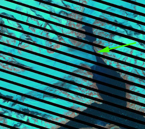
During the Austral winter between April and September, 2012 the Thwaites Glacier a large outlet glacier of the West Antarctic ice Sheet experienced a major calving event, as was pointed out by a reader on this blog. This is along with Pine Island Glacier often considered the weak underbelly of the ice sheet. MODIS imagery from February, March, September and October is used here to illustrate the event. The red, magenta and green arrows point to the same location in each image. The blue dots mark the ice front. The orange arrow points to a portion of the Thwaites Glacier Ice Tongue that had previously calved in 2002/03. In the latter two images the yellow arrow indicates the new ice tongue piece that has broken off. 


 This is an important glacier along with the A video using MODIS and Landsat imagery notes the 2012 changes and the number and size of new icebergs from the glacier. Pine Island Glacier as they both tap into the heart of the WAIS but lack big buttressing ice shelves. This is why in 1985 I was busy preparing a bedrock map in front of the glacier from two shipboard seismic transects for Tom Kellogg and Terry Hughes at U Maine. Of course that map did not look nearly as good as the recent ones in Tinto and Bell (2011), from the extensive NASA Operation Icebridge. What they indicate in the two following images from their paper is that the new ice tongue before it broke off was ending on top of a bedrock high (red arrow first image below), that would act as pinning for the ice tongue. The thicker the ice at that point the better the pinning point. This bedrock high is noted in the 3-d with a white arrow. Kirsty Tinto and Robin Bell (2011) of Colubmia University, also did predict a faster retreat for Thwaites Glacier. Rignot et al (2002) noted that the Thwaites Glacier grounding line was in retreat, the mass loss was increasing and the glacier was thinning, though not nearly as fast as Pine Island Glacier. In the last image below from Rignot (2008) the velocity of Pine Island Glacier and Thwaites Glacier is shown, the high velocity region of Thwaites is wider, and this has been expanding ((Rignot et al, 2002). The Thwaites Glacier behavior ice frontal changes and thinning is like the Smith Glacier to its west also. Unlike Petermann Glacier where there is no past history to suggest the terminus will readvance significantly towards its former position, Thwaites Glacier has experienced large calving events in the past, such as 2002/03. The difference on this occasion is that the ice tongue was quite small and hence more stable than in previous calving event occasions. The continued thinning makes the readvance and subsequent pinning on the bedrock ridge less likely. The rifting is also quite extensive as MacGregor et al (2012) had noted, I look forward to the observations that will emerge from NASA’s Operation Ice Bridge in Antarctica that begins in a week.


Category: Glacier Observations
Post detailing changes in a glacier
Godur Glacier, Pakistan Retreat and Separation
Godur Glacier drains into Godur Lake (Godar) in the Hindu Kush Mountains of Northwest Frontier Province, Pakistan and then into the Swat Valley and then Indus River. ICIMOD (2010) noted there were 233 glaciers with an area of 223 square kilometers in the Swat Valley region, this indicates numerous but generally small glaciers. ICIMOD (2010) also examines the changing climate conditions in the region, noting that the change in precipitation has been minor, while temperatures have risen markedly and the frequency of heat waves has increased (first image, from ICIMOD, 1960-2010). The main accumulation season for the glaciers in this area is in the winter season, with the summer monsoon playing a small role. In 1998 and 2000 the Godur Glacier terminus was a location where two tributaries joined, red arrows. By 2011 the retreat had led to separation of the two glaciers. The separation has increased in the divide between the glaciers, yellow arrow. the west margin of the glacier has also retreated, note the distance from the lake to the edge of the glacier in 1998 versus 2011, green arrow.


 The retreat of this glacier and the enhanced melting through the Hindu Kush will lead to changes in timing of runoff in the Indus River. The net annual runoff depends largely on precipitation, which has not shown a clear trend. However, during heat waves extensive melting can lead to high water levels in the Indus River, well long term retreat leads to decreased summer melt and runoff. The retreat here parallels that seen to the west in Afghanistan (Emend Valley glaciers) and to the west in the Himichal Pradesh (Malana Glacier).
Knife Point Glacier Retreat (Dissappearing), Wind River Range, Wyoming
The Wind River Range is host to 40 glaciers that all have retreated significantly over the last 25 years and 45 years. Of the 15 glaciers observed in detail, nine will not survive current climate (Pelto, 2008). This is based on the lack of a persistent and consistent accumulation zone essential for glacier survival (Pelto, 2010). Thompson et al (2011) quantified the loss in area, of the 44 glaciers was estimated to be 45.9 km2 in 1966 and 28.6 km2 in 2006, a decrease of 38%. Here we examine Knife Point Glacier using Google Earth images from 1994, 2006, 2012 Landsat imagery and some 2012 photographs. The magnificent photographs are from Sarah T, who during the course of an impressive 2012 climbing season, climbed Knife Point. A comparison of its extent from 1966 USGS map, 1994 USGS aerial photography and 2006 satellite image in Google Earth indicate the retreat. The 1966 glacier boundary is outlined in orange, 1994 boundary in green, 2006 boundary in red and 2012 boundary in purple. The arrows in each image point to the same location. The yellow arrow to the 2006 terminus, green arrow to the upper glacier rock outcrop, magenta arrow to the prominent ridges now marking either side of the glacier, and the red arrow the bedrock knob that is now just above the terminus. In 1966 the glacier was connected to the Bull Lake Glacier to its northwest. By 1994 the glaciers were separated and a small lake had formed at the eastern terminus. By 2006 the eastern lake had largely filled in with sediment and another small lake had formed and the eastern side of the glacier had retreated more than the terminus. By 2012 the glacier shape had become confined to the central basin at the top with a narrowing glacier terminus tongue. The glacier area has declined from 1.5 km2 in 1966 to 0.8 km2 in 2012, a 46% loss in area. The main terminus has retreated 360 meters from 1966-2012. The width of the glacier on the east side has declined by 300 m. At the green arrow a small bedrock knob has expanded from 1966-2012. This is in the middle of the accumulation zone and indicates the lack of persistent and consistent snowcover. There is almost no snowcover left in the 9/27/2012 image of Knife Point Glacier. 


The images from Sarah T, are from late July and despite there being two months left in the summer season the glacier has lost most of its snowcover. The lack of crevassing despite the slope indicates the thin inactive nature of the glacier. 


The response of this glacier to climate parallels that of Lower Fremont Glacier, Minor Glacier and Sourdough Glacier.
Mount Baker Glacier Hydrologic Year End Update
October 1 marks the end of the hydrologic year. For glaciers this should be the end of the melt season, though this year in the North Cascades it is not. The year began with excellent snowpack in the North Cascades 4th highest since 1984. The ablation is primarily June-September, after a cool June, the melt season has been sustained and warm. The June-Sept. period is the fourth warmest of the 1990-2012 period and the warmest for the July-Sept. There was not exceptional periods of heat, just sustained warmth due to the lack of cool wet systems in the region. This was evident from a period of 47 consecutive days with less than .01 inches of ppt at SeaTac Airport. The warm weather is projected to extend at least through Columbus Day. 
 . Here we will examine Easton Glacier on Mount Baker. On July 20 the snowpack was still extensive covering 100% of the glacier. By August 10 the glacier had substantial blue ice. Note images from new video on research taken then. A series of Landsat images below are from July 20, August 25th and Sept. 26th. The orange areas point to the same locations. For the August and September image there is a second image, the last two in sequence, of each with the glacier outlined by yellow dots and the blue ice zones where the snowpack had melted away a darkened blue. The imagery does not distinguish the exposed 2011 firn from the 2012 snowpack.


 . Comparing images from 8/10/2012 and one month later 9/8/2012 the expansion of bare ice is evident. A marks the western terminus that was surveyed this summer as having experience 310 m of retreat from 1990-2012. B marks an area with average snow depth of 0.7 m on 8/10 and had lost snowpack and 1.4 m of ice by 9/8. The top of the C had snowpack of 1.8 m on 8/10 and by 9/8 was at the snowline. D marks an icefall that has expanded considerably. E marks an area with 5.5 m of snowpack on 8/10 and 3.8 m of snowpack on 9/8. By Sept 30 considerable additional melting had occurred. Final mass balance results will emerge over sometime in November. We measured snowpack depth at over 400 locations on Mount Baker using probing and crevasse stratigraphy, last two images.


Lobbia Glacier Retreat, Italy and World War I relic exposure
The summer of 2012 was a warm one in the Italian Alps. This has led to large losses in glacier volume and exceptional surface melting. One example of this has been the exposure via melting of a considerable amount of World War I relics. One location noted has been the Ago Di Nardis Glacier in the Trentino Mountains, where artillery ammunition is observed Image from Maffei Glauco / Trentino Italian / EPA. In this post we use Landsat imagery from 1999, 2011 and 2012 to examine the retreat of Lobbia Glacier with a small note on the retraction of Ago Di Nardis Glacier. The Lobbia Glacier is adjacent to the Mandrone Glacier that has been examined in detail by the Università di Brescia, Italy (Ranzi et al, 2010), which lost over a meter of ice thickness on average from 1999-2006. The Lobbia Glacier retreat from 1999-2010 has been observed by the Italian Glaciological Survey and found to have retreated 140 meters from 1999-2005, and 45 m from 2006-2009. In the Landsat images the red arrow indicates the retraction in glacier width of Ago Di Nardis Glacier at the 3000 meter level. The Orange dot indicates the 1999 terminus location of Lobbia Glacier. The yellow arrow indicates the expansion of a bare rock area that had been surrounded by ice in 1999 on Lobbia Glacier. The purple arrow indicates the separation of horseshoe shape glacier adjacent to Lobbia Glacier.

 . The glacier has a low slope and few crevasses. The combination indicates low velocity and even stagnant conditions. The slopes on the west side of the glacier, yellow arrow are not retaining snowcover and no longer feed the glacier tongue. The lack of a consistent and persistent snowcover indicates a glacier that cannot survive (Pelto, 2010), image from TecTask. The current glacier health parallels that of Dosde Glacierand Presena Glacier
Emend River Headwaters Glacier Retreat, Hindu Kush, Takhar Province, Afghanistan
The Emend River drains from the Hindu Kush Mountains and joins the Worsaj River and eventually drains into the Amu Darya River. This area is not impacted much by the summer monsoon and glacier runoff is key to summer streamflow. The runoff from the glacier is tapped for extensive irrigation in the valley bottom both along the Emend, and eventually downstream near Taliquan (bottom image).
 At the headwaters of the Emend River, Takhar Province, Afghanistan are a pair of 3 kilometer long glaciers that are the focus of this post. We examine Landsat images from 2000 and 2011 and a Google Earth image from 2004. In 2000 the western glacier ends in a proglacial lake indicated by the purple arrow in each image. By 2007 the glacier has receded 50 meters from the edge of this lake, and by 2011 the glacier has receded 100+ m from the lake. On the eastern glacier in 2000 a small proglacial lake less than 0.1 square kilometer is at the end of the lake, yellow arrow. In the 2007 Google Earth image the lake has expanded as the glacier has retreated and has an area of 0.25 square kilometers. A small additional expansion has occurred by 2011, with the lake area reaching 0.3 square kilometers. Another glacier to the south also in the Emend River watershed has also experienced lake expansion at its terminus, red arrow. This latter lake has expanded from less than 0.1 square kilometers to 0.3 square kilometers in the last decade. These are all small lakes and do not pose a glacier lake outburst flood hazard.
 <
<

A closeup view of the terminus area indicates numerous depressions, green arrows. The depressions are ablation hollows, where more dust has accumulated, and then accentuated ablation, the hollows typically form from wind scouring. The hollows are not water filled, Petrov Glacier also featured similar features. This region of the Hindu Kush has not been the focus of detailed glacier studies. Northeast of Takhar Province in the Wakhan Corridor a group of glaciers was examined by Umesh Haritashya and others (2009) and found 28 of thirty had retreated. Zemestan Glacier is one example. The Hindu Kush follows the pattern of the high mountains of central Asia including the Himalaya.
Mittie Glacier retreat, Ellesmere Island, Canada
The Manson Icefield is in southeast Ellesmere Island, Canada. This icefield has the highest concentration of surging glaciers in the Canadian Arctic Islands (Copland et al, 2003). The Mittie Glacier is the largest such glacier and drains north from the icefield into Smith Bay. Mittie Glacier was noted to be advanacing and surging in 1999-2000 by Copland et al (2003). This surge led to an advance of about 4 km from the 1959 terminus position and peak velocities reached 1 km/year. During this surge extensive crevassing was noted from the terminus to 30 km inland. The surge was noted to continue up until 2008 (Sharp et al, 2011).  A surge is an episodic speed up of a glacier that also tends to lead to glacier advance, this post does not examined velocity data and can address if the surge has ended, here we examine a change in the terminus position of the primary Mittie Glacier and a secondary glacier just east of Mittie Glacier. Here we focus on 2002, 2010 and 2012 imagery to illustrate terminus change of Mitte Glacier. The terminus in each image is indicated by green dots. The 2002 terminus position of the Mittie Glacier is indicated by yellow arrows and the adjacent glacier that did not surge pink arrows in each image for comparison, the 2012 image at the point nearest Mittie Island in 2012 is indicated by a red arrow. In 2000 and 2002 Landsat imagery indicates the Mittie Glacier reaching to Mittie Island. By 2010 and 2012 the glacier has retreated from the island. The glacier has retreated on the northeast corner 4.5 km from Mittie Island. The smaller tributary to the east of the main Mittie Glacier has retreated approximately 1 km. The main change is that Mittie Island was a pinning point for the terminus of the glacier. Without this pinning point the glacier will experience enhanced terminus calving.


 The warm climate conditions of the last three summers and reduced sea ice duration in the area will increase the capacity for retreat of this glacier. The last images is a MODIS image from Aug. 30, 2012 indicating Mittie Island, yellow arrow, and the lack of sea ice in the vicinity of the glacier terminus. The retreat of the terminus from the pinning point is similar to that seen this summer on Thrym Glacier, Greenland.
Malana Glacier Retreat, Himachal Pradesh, India
The Malana Glacier (top image) is at the headwaters of the Malana River in the Himachal Pradesh of India. The glacier feeds the Malana Hydropower Plant (second image) a 108 MW run of river hydropower plant, that lacks a significant reservoir. The Malana River than flows into the Parbati and Beas River. Malana Glacier runoff once in the Beas River feeds hydropower facilities at Larji (120MW: third image), which alters streamflow below it leaving the river bed quite exposed at times (fourth image), Pandoh (990MW) and Pong (360 MW). The Pandoh Dam diverts water out of the basin into the Sutlej System to generate the power, see Sara Umaga Glacier retreat for details. The Malana Valley is very secluded and is sometimes referred to as the Shangri-la. This glacier differs from many of the glaciers in the region that have a heavily debris covered terminus such as the Gangotri or Satopanth. The retreat is similar to that of all glaciers in the region (Kulkarni et al, 2007). and in the high mountains of Asia except the Karokoram


Google Earth image below Larji dam indicating low streamflow near Markanda Temple.
The Malana Glacier flows south from Mt. Indrasan and Mt. Deotibba and has until the last few years turned west where the Manala valleys turns and the Malana Glacier used to join the South Manala Glacier flowing north to this junction point. Here we look at Landsat imagery from 1998, 2000 and 2011. In 1998 and 2000 the glacier turns the corner and begins the western descent to its terminus purple arrow, the narrow tongue of blue in both cases is evident heading west, though further in 1998. There is a prominent bedrock knob, yellow arrow at the western turn on the east side of the glacier. By 2011 the lower 600 meters of the glacier below the western turn has melted away and the glacier now ends at the prominent knob, yellow arrow, there is no tongue of glacier ice turning west. Just above the terminus one significant tributary, green arrow, that had been joined to the glacier during the first ascents in the region in the 1960’s had separated by a short distance in 1998 and 2000. In 2012 this distance has increased as the former tributary also retreats. 

 The Google Earth imagery from 2004 also indicates the glacier turning the corner and descending 400-500 meters ending at an elevation of 3900 meters. A closeup of the terminus indicates the thin uncrevassed nature in 2004 suggesting that this section was largely stagnant and melting away. The 2004 terminus is indicated with green dots and the 2012 terminus with yellow dots.
Des Poilus Glacier Retreat, British Columbia
Des Poilus Glacier, British Columbia is at the southwest corner of the Wapta Icefield in Yoho National Park. The glacier flow south at a relatively low slope from the slopes of Mt. Des Poilus. The glacier retreated 500 m, a rate of 15-18 m/year, from 1950-1980.  In this post we examine the continued retreat and development of a new lake at the terminus of the glacier using Landsat imagery from 1988, 2001 and 2012. In 1988 no lake exist at the terminus, red arrrow. The glacier extends well past the prominent ridge on the east side of the glacier shortly above the terminus, yellow arrow. The blue arrow indicates that the snowline is very high 2650 m, which is 200 m higher than that necessary for the glacier to be in equilibrium. By 2001 a small lake had developed along the west side of the glacier and the glacier had retreated 300 meters from 1988. By 2012 a substantial lake has developed that is 600 m long and 500 m wide. The glacier has retreated beyond the prominent ridge east of the glacier, yellow arrow. Total retreat from 1988 is 800 meters and 450-500 meters since 2001. The retreat rate since 1988 has increased to 25-30 m/year since 1988. The snowline despite this being an Aug. 12th image is already at 2600 meters. The issue for this glacier is that the consistent snowline is too high to support the main valley tongue of the Des Poilus Glacier, which will dissappear (Pelto, 2010). The only section of the glacier that maintains snowcover is on the east flank of slopes of Mt. Des Poilus.


This retreat has followed the pattern for glaciers in the area overall (Bolch et al, 2009) from Freshfield Glacier, Columbia Glacierand Washmawapta Glacier.
Glacier Post Index 2009-August 2012
Glacier Index List
Below is a list of the individual glacier posts examining our warming climates impact on each glacier. This represents the first 3.2 years of posts, 228 total posts, 208 different glaciers. I have worked directly on 45. The others are prompted by fine research that I had come across, cited in each post or inquiries from readers and other scientists. I then look at additional often more recent imagery to expand on that research. The imagery comes either from MODIS, Landsat, Geoeye or Google Earth.
United States
Columbia Glacier, Washington
Lyman Glacier, Washington
Boulder Glacier, Washington
Deming Glacier Icefall, Washington
Deming Glacier, Washington
Easton Glacier Assessment, Washington
Mount Baker Mass balance, Washington
Ptarmigan Ridge Glacier, Washington
Anderson Glacier, Washington
Eel Glacier, Washington
Milk Lake Glacier, Washington
Suiattle Glacier, Washington
Paradise Glacier, Washington
Easton Glacier, Washington
Redoubt Glacier, Washington
Honeycomb Glacier, Washington
Vista Glacier, Washington
Rainbow Glacier, Washington
Daniels Glacier, Washington
Colonial Glacier, Washington
Quien Sabe Glacier, Washington
Mazama Glacier
Fairchild Glacier, Washington
White Glacier, Washington
Banded Glacier, Washington
Borealis Glacier, Washington
Hinman Glacier, Washington
Lower Curtis Glacier, Washington
McAllister Glacier, Washington
Lewis Glacier, Washington
Kennedy Glacier, Washington
Fremont Glacier, Wyoming
Minor Glacier, Wyoming
Sourdough Glacier, Wyoming
Grasshopper Glacier, Wyoming
Grasshopper Glacier, Montana
Harrison Glacier, Montana
McDonald Glacier, Montana
Sperry Glacier, Montana
Hopper Glacier, Montana
Old Sun Glacier, Montana
Yakutat Glacier, Alaska
Grand Plateau Glacier, Alaska
Eagle Glacier, Alaska
Gilkey Glacier , Alaska
Gilkey Glacier ogives, Alaska
Lemon Creek Glacier, Alaska
Taku Glacier, Alaska
Bear Lake Glacier, Alaska
Chickamin Glacier, Alaska
Okpilak Glacier, Alaska
Sawyer Glacier, Alaska
Valdez Glacier, Alaska
Antler Glacier, Alaska
Field Glacier
East Taklanika Glacier, Alaska
Brady Glacier, Alaska
Brady Glacier Retreat lake expansion 2004-2010, Alaska
Thiel Glacier, Alaska
Speel Glacier, Alaska
Romanzof Glacier, Alaska
Pedersen Glacier, Alaska
Canada
Icemantle Glacier, BC
Bridge Glacier, British Columbia
Washmawapta Glacier, British Columbia
Bubagoo Glacier, British Columbia
Hector Glacier, Alberta
Helm Glacier, British Columbia
Jacobsen Glacier, British Columbia
Melbern Glacier
Warren Glacier, British Columbia
Castle Creek Glacier, British Columbia
Hoboe Glacier, British Columbia
Coleman Glacier, British Columbia
Tulsequah Glacier, British Columbia
Decker and Spearhead Glacier, British Columbia
Columbia Glacier, British Columbia
Freshfield Glacier, British Columbia
Apex Glacier, British Columbia
Great Glacier, British Columbia
Devon Ice Cap, Nunavut
Penny ice Cap, Nunavut
Northern Outlet Devon Ice Cap, Nunavut
Penny Ice Cap SW, Nunavut
Snowshoe Peak, Yukon
Petain Glacier, Alberta
New Zealand
Tasman Glacier
Murchison Glacier
Donne Glacier
Mueller Glacier, NZ
Gunn Glacier, NZ
Africa
Rwenzori Glaciers
Tyndall Glacier, Kenya
Himalaya
Ngozumpa Glacier, Nepal
West Barun Glacier, Nepal
Samudra Tupa, India
Longbasba Glacier, Tibet
Zemu Glacier, Sikkim
North Lhonak Glacier, Sikkim
Theri Kang Glacier, Bhutan
Zemestan Glacier, Afghanistan
Khumbu Glacier, Nepal
Imja Glacier, Nepal
Gangotri Glacier, India
Milam Glacier, India
Satopanth Glacier, India
Kali Gandaki Headwaters, Nepal
Menlung Glacier, Tibet
Boshula Glaciers, Tibet
Urumquihe Glacier, Tibet
Sara Umaga Glacier, India
Dzhungharia Alatau, Kazakhstan
Petrov Glacier,Kyrgyzstan
Hailuogou Glacier, China
Reqiang Glacier Retreat, Nepal
Lumding Glacier, Tibet
Himalaya Glacier Index
Europe
Taconnaz GLacier, France
Mer de Glace, France
Dargentiere Glacier, France
Grand Motte and Pramort Glacier Tignes Ski area, France
Saint Sorlin, France
Sommelier Glacier
Obeeraar Glacier, Austria
Ochsentaler Glacier, Austria
Pitzal Glacier, Austria
Dosde Glacier, Italy
Maladeta Glacier, Spain
Presena Glacier, Italy
Sabbione Glacier Retreat
Triftgletscher, Switzerland
Gietro Glacier, Switzerland
Rotmoosferner, Austria
Stubai Glacier, Austria
Hallstatter Glacier, Austria
Ried Glacier, Switzerland
Cavagnoli Glacier, Switzerland
Chuebodengletscher and Ghiacciaio-del-Pizzo-Rotondo
Forni Glacier, Italy
Careser Glacier, Italy
Peridido Glacier, Spain
Engabreen, Norway
Midtdalsbreen, Norway
Tunsbergdalsbreen, Norway
TungnaarJokull, Iceland
Langjökull, Iceland
Gigjokull, Iceland
Skeidararjokull, Iceland
Kotlujokull, Iceland
Lednik Fytnargin, Russia
Rembesdalsskaka, Norway
Irik Glacier, Mount Elbrus, Russia
Greenland and European Arctic
Mittivakkat Glacier
Ryder Glacier
Humboldt Glacier
Petermann Glacier
Kuussuup Sermia
Thrym Glacier Retreat
Tiningnilik Glacier Lake
Jakobshavn Isbrae
Zachariae Isstrom
Umiamako Glacier
Alison Gletscher
Kong Oscar, Glacier
De Reste Bugt
Upernavik Glacier
Epiq Sermia
Sarqardliup Seremia
Steensby Glacier
Sortebrae Glacier, Greenland
Severnaya Zemlya, Russian Arctic
Hansbreen, Svalbard
Nannbreen, Svalbard
Hornbreen and Hambergbreen, Svalbard
Olsokbreen, Svalbard
Albrechtbreen, Svalbard
Roze and Sredniy Glacier, Novaya Zemyla
Nizkiy and Glazova Glacier, Novaya Zemyla
South America
Colonia Glacier, Chile
Artesonraju Glacier, Peru
Nef Glacier, Chile
Tyndall Glacier, Chile
Alemania Glacier, Chile
Zongo Glacier, Bolivia
Sierra Nevade del Cocuy Glaciers, Colombia
Ritacuba Blanco Glacier, Colombia
Llaca Glacier, Peru
Joerg Montt Glacier, Chile
Arhuey Glacier, Peru
Seco Glacier, Argentina
Onelli Glacier, Argentina
Quelccaya Ice Cap, Peru
Glacier Gualas, Chile
Antarctica and Circum Antarctic Islands
Pine Island Glacier
Fleming Glacier
Hariot Glacier
Smith Glacier, Antarctica
Amsler Island
Stephenson Glacier, Heard Island
Neumayer, South Georgia
Ampere, Kerguelen
Cook Ice Cap, Kerguelen Island
Nordenskjold Coast, Antarctic Peninsula
Prospect Glacier, Antarctic Peninsula
Ross Hindle Glacier, South Georgia
Vega Island Ice Cap
Rohss Bay, James Ross Island, Antarctica
North Cascade Glacier Climate Project Reports
Forecasting Glacier Survival
North Cascade Glacier Mass Balance 2010
Columbia Glacier Annual Time Lapse
North Cascade Glacier Climate Project 2009 field season
28th Field Season Schedule of the North Cascade Glacier Climate Project
North Cascade Glacier Climate Project 2011 Field Season
BAMS 2010 alpine glaciers
BAMS 2011 Alpine Glaciers
2011 Glacier mass balance North Cascades and Juneau Icefield
Taku Glacier TSL Paper
Glacier Ground Truth 2012 North Cascade Field Season
North Cascade Glacier Climate Project 2012 Field Season
Thrym Glacier Retreat, Greenland
Thrym Glacier in southeast Greenland is a marine terminating outlet glacier at the head of Skjoljungen Fjord. This post focuses on Landsat images from 2000, 2004 and 2012. During the last decade several changes of significant are evident at the terminus of the glacier. This glacier was one of the glaciers that was a focus of a recent examination of Greenland glacier marginal change over the last 80 years by Bjork et al (2012) (detailed supplement). Thrym Glacier’s terminus in 2000 was connected with a second glacier flowing from the north, a branch of the Maelkevejen. The first change since 2000 is the opening of a channel between the terminus of the glacier and the fjord wall (green arrow) on the east side of the valley. This removes a pinning point for the glacier that should enable an increase of calving in the greater water depths. At the junction of the two glacier a lake has developed that now is part of the fjord. This water body has expanded to 2.5 km in length and 1.5 in width (yellow arrow). Upglacier of the terminus the glacier is fed by many tributaries, one of these has separated from the glacier in the last decade and is no longer feeding ice into the system, purple arrow.
Landsat image 2000

Landsat image 2004
 Landsat image 2012
A close up view of the glacier terminus and new outlet also indicates the drop in water level of the developing lake in 2000 that has now become part of the fjord in 2012, images below. The red arrows indicate the recession of shoreline as the fjord opened and water levels dropped. The actual retreat of the glacier margin ranges from 200-400 meters during the last decade, fairly minor, but the changes will lead to a more dramatic retreat in the near future. John Mercer of Ohio State(1961) was the first to write about the importance of pinning points to stability of a terminus. Brown et al (1982) of the USGS, quantified the strong direct relationship between water depth and calving rate on Alaskan glaciers, Pelto and Warren (1991) noted that this relationship extended with to Greenland glaciers. The current terminus position of Thrym Glacier having just moved into deeper water and fronted now by tidal front along its entire front, is not in a stable position. The glacier will now have to retreat into the narrower valley, to reduce its calving rate. In June of 2013 the opening remains unchanged, indicating no terminus advance during the winter season. Historic photographs of this glacier dating back to World War II indicate the outlet had been closed throughout the latter half of the 20th century. The retreat of this glacier follows the regional pattern observed on Sortebrae Glacier and De Reste Bugt Glacier
Landsat image 2000

Landsat image 2012
 Landsat image 2013
