
The Penny Ice Cap is extends north from the Pangnirtung Pass regiion of Baffin Island. . To capture the majesty of the region, you have to turn to the artwork of Cory Trepanier, seen below is his Great Glacier study, not to the science data.
  The ice cap has been shrinking as evidenced by the retreat of a number of outlet glaciers. This post focuses on two of these glaciers. The first is Turner Glacier which flows 11 km downvalley from the ice cap ending in the Pangnirtung Valley. In 1961Turner Glacier reached to the summit lake in Pangnirtung Pass. In 1953 the glacier front was also much wider as seen in an Arctic Institute of North America Photograph. In the images below Turner Glacier enters from the left center of the image. By 2004 (top image) the glacier had receded 280 meters from the lake shore and 600 meters from the moraine it was in contact with in 1953. By 2009 the retreat was 570 meters from the lake shore and 900 meters from the moraine, bottom image. The 2009 image is an August 2009 Landsat Image.
 . In particular retreat after 2000 has been more rapid. Coronation Glacier is the largest outlet glacier of the Penny Ice Cap, it extends 35 km from the edge of the ice cap terminating in Coronation Fjord. Syvitski (1992) noted that Coronation glacier has been retreated at an average rate of 12 meters per year from 1890-1988Coronation Glacier. The focus at Coronation Glacier (C) is the imagery from 2004 and 2009 both indicating a lack of snow cover on some of the small glaciers adjacent to this glacier. Glaciers A and B are nearly snow free in both summers, and this is still in August. The small glacier labelled D is snow free in 2009.
 . In this five year interval The Coronation Glacier has retreated 200 m. Note the change in the glacier terminus position with respect to the stream entering the north side of the fjord at the terminus. The limited snow cover on Baffin Island mirrors that of most of the Canadian Arctic in recent years with high melt rates leading to mass balance losses and sea level rise as published this week by Gardner and others (2011).
Category: Glacier Observations
Post detailing changes in a glacier
Theri Kang Glacier Retreat Bhutan
One of the glaciers draining north from Theri Kang in Bhutan terminates in proglacial lake, that is a lake at the glacier front. This is an unnamed glaciers like its neighbors, we will refer to it as the Theri Kang Glacier. The glacier has retreated 1700 meters from the moraine complex that impound the lake. The terminus is at 5200 meters, the snowline is at 5800 meters and the summit of the glacier is near 6700 meters. The vegetation adjacent to the glacier is indicative of the overall dry climate in the region. This is also a cold climate with permafrost in the areas adjacent to the glacier. The lake is not in evidence in maps of the region from the 1960’s.  Kääb (2005) in Figure 7b examined the velocity of this glacier using ASTER imagery he found that most of the lower glacier extending from where the tributaries join to the terminus moved at a velocity of 50 m per year. A comparison of this 2001 image overlain in Google Earth and the more recent 2009 imagery indicate this glacier has retreated 300 meters in eight years. The 2001 image is from NASA.The red line in the 2001 image indicates the 2009 terminus.
 The lake has expanded from 1500 meters in length to 1800 meters and now encompasses nearly 2 square kilometers. Often there is concern about glacier lake outburst floods from lakes dammed either by a glacier or impounded, as in this case, by its moraine. For the Theri Kang the moraine complex appears quite wide, and stable and is not of great concern. The 2013 Landsat image does not show significant retreat after 2009.
2013 Landsat Image
The lower portion of the glacier is debris covered along the lateral margins, but the clean ice portion has an interesting pattern, that is typical of a glacier in a drier climate where sublimation is an important element of the ablation process, dominating over melting. Sublimation is the direct transfer of solid ice to water vapor without melting. That is the crevasse pattern becomes a series of prominent crests almost waves that persists in the absence of the crevasses that formed them. This persistence would not occur in a zone dominated by melting.  Though the setting is much different the response to climate is the same as almost all Himalayan glaciers from the Zemu Glacier in Sikkim, to Lugge Glacier, Bhutan, to Imja Glacier in Nepal
Maladeta Glacier retreat, forecast not to survive
Maladeta Glacier is located amongst the highest peaks in the Pyrenees and is on same mountain massif as the largest glacier in the Pyrenees, Aneto Glacier. Chueca et al (2007) noted that the glacier has retreated significantly from 1935 to 1957 and 1981-2010. From 2001-2005 the glacier retreated 120 m. The glacier in 2008 was 700 m long. They also noted that Maladeta Glacier has lost 70% of its area from 1850 to 2007, from 1.5 square kilometers to 0.45 square kilometers. The glacier is seen below in an image from the WGMS. Miguel Arenillas from the Polytechnic University of Madrid has reported thee mass balance from 2001-2009 to the World Glacier Monitoring Service was -8.4 meters. Given the estimated glacier thickness of 30-40 meters, this loss in the last decade represents approximately 25% of the glacier lost in a single decade. The behavior follows that of other Pyrenees glaciers, in 2004-2005 15 of 16 glaciers observed and reported to the WGMS retreated.Chueca et al (2007) identified that these changes have been forced by a reduction in the snowfall contributions and increase in the maximum temperatures during the past few decades in the Pyrenees. The 2008 Google Earth image indicates a glacier almost devoid of snowcover. It is also evident in the Google Earth images and a view of the glacier from below the terminus, that the glacier is quite thin in the lower reaches and has very limited crevassing. Both suggest a glacier with minimal movement. In the first image from 2008 the lower margin of the glacier is indicated by a blue line.

 The lack of a substantial accumulation has led to the large negative mass balances. To survive a glacier must have a persistent and consistent accumulation zone. The lack of a consistent accumulation zone on Maladeta Glacier will lead to the total loss of this glacier in the next 20-30 years. Given that at least 16 glaciers have disappeared in the last thirty years in the Pyrenees, it will not be the exception.
Ochsentaler, Austria Rapid Glacier Retreat
Ochsentaler is a glacier in the Silvretta group of southwest Austria. From 1990 to 1995 the glacier retreated 75 meters, from 1995-2000 85 meters, and from 2000-2005 180 m. The accelerating retreat has been driven by substantial negative mass balances. Dyugerov and others (2009) assessed the mass balance of the glacier as averaging -0.5 meters per year lost, from the percentage of snowcovered area remaining at the end of the summer.  Measurements on the neighboring Jamtalferner in Austria indicate 15 m of loss from 1990-2009, about 0.75 meters per year. Mass balance losses on Silvretta Glacier, Switzerland indicate a 13 m loss during that same period. Examination of the glacier today indicates an uncrevassed, thin stagnant glacier tongue that is 600 meters long, that is and should continue to rapidly melt.
  At the head of this section of the glacier is an icefall. The newly exposed bedrock areas at the crest of the icefall indicate reduced iceflow and thinning at this point. The contrast in this icefall region is apparent in the image pair from Christian D. from 1995 and 2011 and the latter image 2009 in Google Earth.

 . Ochsnetaler is a popular climb and the upper section of the glacier above the icefall still has a considerable snow covered extent.
 This glacier is certainly healthier than Stubai Glacieror Presena Glacier and similar to Rotmoosferner.
Old Sun Glacier Glacier National Park slow retreat
In Glacier National Park, MT all glaciers have been retreating. From 1850 to the present the number of glaciers has been reduced from 150 to 25. There are a few glacier such as Old Sun Glacier that have been retreating quite slowly since 1966 when the USGS maps were completed and are not disappearing anytime soon. Old Sun Glacier faces northeast and terminates at 8200 feet. This is a higher altitude than the rapidly shrinking Sperry Glacier, 7600 feet or Grinnell Glacier 6600 feet. A comparison of Google Earth images of Old Sun Glacier from the 1966 USGS map to 2009 indicate that the glacier has thinned and retreated but the majority of the glacier remains. The loss of area was noted as 12% from 1966-2005 and 14% by 2009. Below is the 1966 image, 1991 image, the strong brown line is the 1991 margin, 2003 image, 2005 image and the last two are 2009 images. 


 The upper section of the glacier retains accumulation even in the poorest years such as 2009 and the glacier remains crevasses. The number of crevasses, slow recession and healthy accumulation zone point to a glacier that with present climate can be forecast to survive Pelto (2010). As long as a glacier maintains an accumulation zone it can survive at a reduced size. There are seven glaciers in Glacier National Park that have a consistent accumulation zone today each of these as a result is diminishing slowly,compared to the majority that have and will soon disappear.
Colonia Glacier Retreat and Glacier Lake Outburst Floods
Colonia Glacier drains east from the Northern Patagonia Icefield feeding the Baker River, Chile. The recent substantial retreat of Colonia Glacier like Glacier Nef just to its north is posing new hazards. The glacier is unusual in the number of lakes that are adjacent to or feed into the adjacent glacier damed or proglacial lakes. In the image below Lake A=Arco Lake, Lake B=East Terminal Lake, Lake C=Cachet 1 , Lake D= West terminal Lake, Lake E=Colonia Lake and Lake F=Cachet 2.  The glaciers recent retreat and glacier lake outburst floods have been closely monitored by the Laboratorio de Glaciología in Valdivia, Chile.Aniya and others (1999)observed that Colonia Glacier began a rapid retreat after 1985
Superimposition of a RADARSAT image from 1997 and a Landsat 1987 image indicated a retreat of
400 m, from 1997-2005 the retreat has further accelerated, with a general frontal retreat of 2.5 km.  Rivera and others (2007) observed that the Colonia Glacier had lost 9.1 square kilometers of area from 1979-2001, which is 3% of the total glacier area. The Laboratorio de Glaciologia’s
In the spring of 2008 Baker River suddenly tripled in size, in less than 48 hours, roads, bridges, and farms were severely damaged. Lake Cachet 2 had vanished the 5 square kilometer glacial lake had emptied 200 million cubic meters of water in just a matter of hours. This lake drained beneath the glacier after sufficient water had filled the lake to buoy part of the glacier and subglacial conduits had begun to develop. Since Cachet 2 emptied in April 2008, the lake has emptied five more times October,
December 2008, March and September 2009 and March 2010, with peak flows released of  3000 cubic meters per second. Below are images of Cachet 2 half- full in Google Earth Imagery from Sept 2008 (note trimline above lake), and full after the flood on 5/28/2008 and empty on 4/8/2008, and lastly the image of the Colonia River’s wide fresh braided stream channel flowing into the Baker River. The newly deposited material from the flood is what makes the wide braided valley such a fresh sediment brown color.
![]()
 The two lakes at the terminus of the glacier did not exist in 1979, the western most terminus lake (B) drained into the easternmost terminus lake (D) via a sub-glacial tunnel after formation in the late 1980’s until 2005 when a channel was cut right through the glacier terminus. This is evident in the image below, there is still glacier ice on both sides of this drainage channel.
 The development and demise of glacier dammed lakes and the resultant problem of glacier lake outburst floods is not rare today, Imja Glacier, and Tulsequah Glacier are other examples. In the case of Baker River the outburst floods are a threat to the planned hydropower developments as documented by Dusaillant and others (2009). The Colonia Glacier retreat mirrors that of Glacier Nef the next major glacier to the north. Hidroaysen Project is proposing 5 dams on the Baker and Pascua River generating 2750 MW of power. Glacier Nef retreated 3400 m from 1945-2000, 2400 m retreat of the retreat occurred in the 1994 collapse of the terminus tongue into the proglacial lake, which is now 3.5 km long. This retreat includes that of , Gualas GlacierReichert Glacier, Steffen Glacier, and Nef Glacier.
Boshula Mountains, Tibet Glacier retreat
Increasing number and area of glacial lake in the Boshula Mountains, Tibet. Wang and others (2011) note that Glacial lakes have expanded from 1970-2009 by 19 % and the area that is glacier covered has decline by 13% during the 1970-2009 period in the Boshula Range. An examination of one unnamed glacier in this range illustrates this pattern. The glacier currently terminates at 4820 meters, the top of the glacier is at 5560 meters.  The glacier terminated at 4660 meter during the Little Ice Age. The glacier has retreated 1950 meters from the evident Little Ice Age moraines and 670 m from the edge of the lake that is beyond the glacier terminus. The glacier was almost to the shore of the lake in 1970 and has retreated 580 meters since then. The glacier was also separated by only a short distance from a tributary glacier that has experienced a 700 meter retreat since 1970, seen in the second image below. By comparing the height of the lateral moraine at the glacier terminus and at 5200 meters the amount of thinning can be identified.
 Thinning of the glacier is 140 m at the terminus and 60 meters at 5200 meters. Melt season temperature and accumulation season precipitation are the key factors in glacier mass balance which translates to glacier terminus behavior. For the Boshula Mountains the main accumulation season is the summer monsoon, which is also lower on the glacier the main melt season. At Bomi 70 km west of the glaciers Wang and others (2011) note that summer precipitation has declined slightly since 1970 while summer temperatures have rise 1 C. It is the rising temperature that has been the key reason for retreat of the glaciers and consequent exposure of new lakes and expansion of older lakes at glacier termini. The frequent summer snowfall on the upper 60% of the glacier prevent surface soot from impacting ablation on the majority of the glacier. Solar radiation is highest during the summer, but soot deposits are at their lowest during the summer monsoon and are also buried over most of the glacier by new snowfall.
  Fits with other Chinese glaciers with a trend becoming increasigly negative for mass balance leading to faster retreat after 1975 Ding and others (2006) The Bushula Range glacier that is focussed on here drains into the Salween River as does the 33, km long Laigu Glacier,seen below,
 one of the headwaters of the Salween.
Saywer Glacier, Alaska Retreat
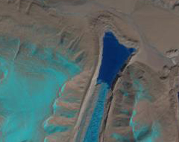
Sawyer Glacier is an Alaskan glacier that many people have observed the retreat of. It is one of three glaciers that calves into Tracy Fjord, that is often visited by cruise ships. The 2.3 km retreat over the last 50 years has made approach to the actual terminus difficult for larger cruise ships. The terminus of the glacier was almost to the main arm of the fjord in 1961, USGS map, blue arrow. The 2003 Google Earth images indicates a 2.3 km retreat, green arrow. 
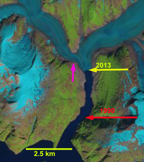
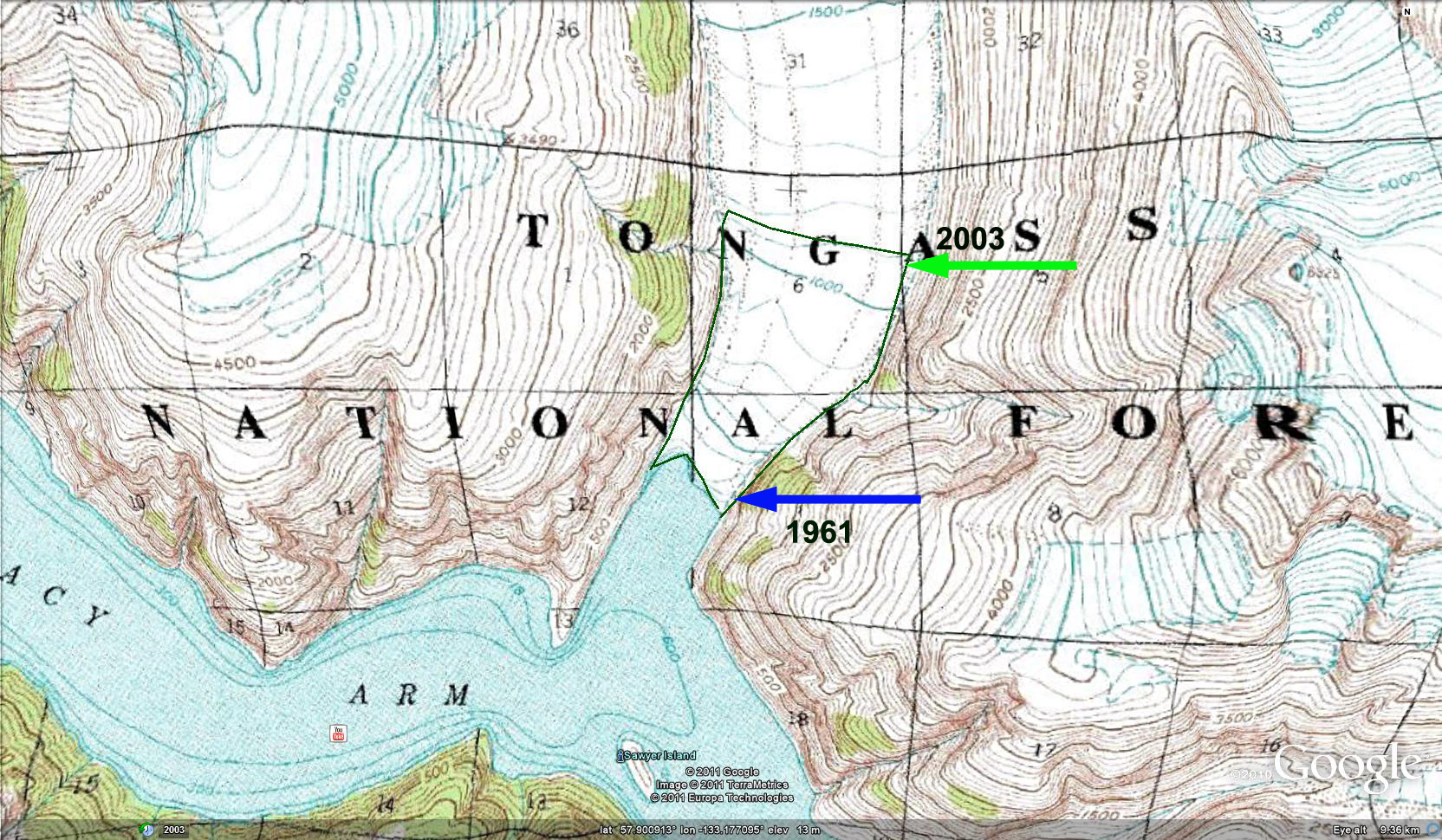 The green line down fjord marks the 1961 terminus, the upfjord line is at the 1100 foot contour of the USGS map and is parallel with the current terminus location. The snowline of the glacier was noted to be at 1125 meters by Pelto (1987), using Landsat images. At the time usable images were rare. Today images are acquired daily by MODIS and if the weather is clear, which is not common, the snow line is evident. Recent satellite images from 2006 and 2009 indicate the snow line still in the 1100 to 1200 meter elevation region, however, the 300+ meter thinning at the terminus has led to thinning upglacier and the location of the 1100 meter contour has shifted 1-1.5 kilometers upglacier. The snowline is evident in the 2003 Google Earth image. Landsat images from 1990 to 2013 indicate extensive retreat. The retreat from the 1990 terminus, red arrow, to the 2013 terminus, yellow arrow is 2.8 km, 120 m per year. The western feeder just above the terminus has narrowed at the pink arrow from 1 km wide in 1990 to 500 m wide in 2013. This suggests that retreat will soon lead to separation of Sawyer Glacier with the western arm and eastern arm both continuing a retreat. The 300 meter thinning in the last 50 years has left a sharp trimline beyond the current terminus marking the former ice height, that is well above the current fjord. The glacier is losing mass and retreating as is the nearby North Dawes Glacier.


 The thinning combined with the rising snowline has resulted in a smaller accumulation zone. At the same time the retreat has reduced the calving rate as the terminus has narrowed and entered shallower water. The calving rate is related to water depth on these glaciers, Pelto (1991) . The reduced calving leads to a more positive mass balance, the increased snow line and reduce height of the glacier surface leads to reduced mass balance. This is equivalent to your bank account when you finish paying off your mortgage, but at the same time your income is declining. It will be interesting to observe the balance point of these two opposite forces. The University of Alaska Fairbanks began periodic altimeter surveys of the glaciers in the Sawyer Glacier region in 2000 and have noted a sharp decrease in surface elevation from the terminus to 1000 meters for the 2000-2009 period (Larsen et al, 2009).
Warren Glacier Retreat, British Columbia, Canada
Warren Glacier in Garibaldi Provincial Park, British Columbia, Canada terminus retreat has been observed for over a century.  A period of extensive retreat from 1890-1964 was followed by a period of minor advance from 1973-1977, and then rapid retreat from 1977-2009. Johannes Koch has documented this retreat in the map below and with the historic images as well, the work has been published with less colorful graphics (Koch et al., 2009).
 . When I first saw the glacier in 1986 it had just retreated from the edge of the lake. By 2003 as seen in the somewhat blurry satellite image below, the glacier was 310 meters from the lake edge. In the 2009 Google Earth image the glacier is 500 meters from the lake edge. The rate of retreat over the 25 year period is 20 meters per year. The rate of retreat has again increased from 2003-2009, being 32 meters/year.
 The upper section of the glacier has unlike nearby Helm Glacier maintained some snow covered areas even in poor snow summers such as 2005 and 2009. This suggests the glacier can survive current climate with further retreat. The average thinning of Warren Glacier is similar to that of Helm, Sphinx and Sentinel Glacier at nearly 50 meters since 1928, note Figure 14 (Koch et al. 2009). This thinning due to ongoing negative mass balance has led to a 50% reduction in area since 1928. The large area loss as a percentage reflects the large relatively flat low lying basin now occupied by the lake.
Murchison Glacier Retreat Increasing
Murchison Glacier drains southeast from the Mount Cook region, one valley east of Tasman Glacier. The end of the glacier terminates in a lake that is rapidly developing as the glacier retreats.  This retreat will become rapid as 2010 imagery indicates other proglacial lakes have now developed 3.5 km above the actual terminus. These lakes are at a higher elevation and may not endure but do help increase ablation, and in the image below show a glacier that is too narrow to provide flow to the lower 3.5 km. The increased retreat has been forecast by the NIWAand Dykes et al (2009)
  This lower section is debris covered, stagnant, relatively flat and will not survive long. The demise of the lower section of this glacier will parallel that of Tasman Glacier. The glacier has retreated 2200 meters from the moraines at the south end of the lake. There was not a lake in the 1972 map of the region. A comparison of 2006 and 2010 imagery indicates the decrease in glaciated area in the lake basin. The bottom image is from NASA after the Feb. 2011 earthquake near Christchurch that led to a major calving event of a portion of the rotten stagnant terminus reach of the Tasman Glacier. There is no evident calving event from Murchison Glacier. The lake on the western margin of the valley, separated from the main lake has since April 2010 expanded notably

 .
.  The glacier still has a significant accumulation area above 1650 m to survive at a smaller size. The lower debris covered tongue is 6 km long and extends from the terminus at 1050 meters to 1200 meters, a very low gradient to supply healthy flow from the accumulation area. The ongoing retreat is triggered by warming and a rise in the snowline in the New Zealand Alps observed by the NIWA
 .
.
Mittivakkat Glacier Retreat, Greenland
A paper by Mernild and others (2011) focusses on the Mittivakkat Glacier on the east coast of Greenland. The glacier is separate from the Greenland Ice Sheet and its climate response as a result more rapid and more similar to other alpine glaciers. Mernild and others (2011) observe that the glacier has retreated 1300 meters since 1931 and that it has had a considerable negative mass balance since 1995. Sebastian Mernild at the Climate, Ocean, and Sea Ice Modeling Group, Computational Physics and Methods, Los Alamos National Laboratory, Los Alamos, New Mexico has provided the pictures that document the terminus change. The field observations is completed in conjunction with Aarhus University and University of Copenhagen, both in Denmark. Notice the glacier ends just short of the coastline in 1931, but in 2006 is 1500 meters from the coastline. 
 Mittivakkat Glacier has a mass balance record since 1995, that is reported to the World Glacier Monitoring Service. During the 1995-2010 period the glacier’s average balance has been -0.87 meters/year. The cumulative loss is -13 m, with the highest loss being in 2010 at -2.16 m. The 13 m loss in water equivalent snow-ice is equivalent to more than 14 m of ice thickness and 15% of the glaciers entire volume. The problem for the glacier is the loss of essentially all of its snow cover in four of the last ten years, this is not a recipe for long term glacier survival (Pelto, 2010). The image immediately below is a Digital Globe image from July 2005 indicating the snow covered area with six weeks left in the melt season is already limited, the glacier is in the center of the image and is the largest ice mass by far. The middle image from 2006 has areas of firn exposed indicated with blue arrows, this is not the end of the melt season yet. The lower image is from August 26 2010 and is a MODIS image catalogued by the Danish Meteorological Institute.The arrow indicates the glacier which has only 10% snow covered area, with a couple of weeks of melting left in the season.

 In 2010 air temperatures at Tasiilaq a few kilometers from the glacier were in the range of 1.5 C above average leading to twice the normal melt rate at the terminus, which will generate an even more rapid retreat for 2010 and 2011. The high temperatures in 2010 were not limited to this location as noted by Jason Box of Ohio State. The high melt rates were as a result not limited to the Mittivakkat Glacier as observed by the record melting reported in the Arctic Report Card. The recent large negative balances will generate ongoing retreat. Mernild observes that in 2011 the mass balance was even larger than -2.45 m An image provided by Sebastian Mernild indicates a whole in the glacier near the terminus, indicating rapid retreat in the near future.
Redoubt Glacier Retreat, Washington
Redoubt Glacier, Washington is the northern most large glacier in the North Cascades. It drains into Depot Creek which flow north into British Columbia. The glacier began advancing in the 1950’s reaching the edge of steep cliff and in three locations spilling down this cliff. At the time of my first visit in 1984 the glacier was still advancing, 2 meters during that year. By 1988 it had begun to retreat, 22 meters total, as all North Cascades were by 1990. The glacier as shown in USGS maps based on aerial photographs, illustrates the margin of the glacier in 1978, this glacier margin is outlined in dark green and is apparent in the several Google Earth images used below. By 1984 photographs by Dale Kalamasz, though I was there, his photographs are much better, illustrate the extent of the glacier. 


 From 1984 to 2009 the glacier has retreated 100-400 meters along its front, with an average of 230 m. Given the main glacier (above) averages 1.5 km from top to bottom this is a significant portion of the glacier. There are no longer ice tongues spilling down the cliffs at the terminus. The western section (below) of the glacier has lost the greatest area, as the retreat is comparable but the glacier length is closer to a kilometer.
 If you looked up at the glacier from the small lake below the center of the margin, “Ouzel lake”, picture above the green line indicates the 1984 margin and the retreat since. It is typical for broad glaciers like the Redoubt to have less terminus retreat. The terminus change is evident in another view, the two lower images of the glacier from the 2009 Google Earth view and a photograph from 2009.


