
Most alpine glaciers in the world remain unnamed, many of these are small, but some are just remote. Their story is no different from the named glaciers. An example is the glacier that drains the north side of Gora Fytnargin (4123 m). I will designate this Lednik “Fytnargin” for the purposes of this discussion. This glacier drains north from the boundary of Georgia and North Ossettia, Russia. The terminus is at 2460 meters, the top at 4100 meters and the snowline at 3200 m.  Google Earth provides two excellent views of the lower glacier from September 2006 (top image below) and September, 2009 (bottom image). In this three year interval the terminus of the glacier has retreated 450 meters. In 2006 a debris stagnant terminus area exists, that entirely melted away in three years.
 . The retreat of this glacier follows the pattern of glaciers in the region that are monitored. Stokes et al (2007) used satellite imagery to observe 113 glaciers in the region from 1980-2000 and found 95% to have retreated. They observed that the rate of retreat had increased and that a number of new lakes had formed due to the retreat. Lednik Fytnargin’s terminus has a low slope and limited crevassing and has numerous supraglacial stream channels. The combination of these indicates rapid retreat will continue in the near future. The terminus was located at 2380 m in 2006 and 2460 m in 2009
Category: Glacier Observations
Post detailing changes in a glacier
Grand Plateau Glacier Retreat, Alaska
Grand Plateau Glacier drains southwest from Mount Fairweather in southeast Alaska. The glacier advanced during the Little Ice age to the Alaskan coastline. Early maps from 1908 show no lake at the terminus of the glacier. The 1948 map shows three small distinct lakes at the terminus of the main glacier and a just developing lake at the terminus of the southern distributary terminus (D). By 1966 the glacier had retreated enough for the formation of one lake. The distance from the Nunatak N to the terminus was 12 km in 1948. The lake at D is 400 m wide.

USGS map displayed in Google Earth-1948 base images.
Landsat images from 1984, a Google Earth Mosaic of the 2003-2009 period and a Landsat image from 2013 indicate the substantial changes that have occurred. Here both the main terminus and a distributary (D) terminus draining south are examined. The main reference points in each image are the Nunatak, N, and and Island, I. The retreat from 1984-2013 is evident with the yellow arrows indicating the 1984 terminus and pink arrows showing the 2013 terminus location. The distance from the Nunatak to the terminus is 9.6 km in 1984, 6.8 km in the Google Earth image and 3.5 km in 2013. A six kilometer retreat at the glacier center in 30 years. On the north shore of the lake the retreat between arrows is 2.7 km from 1984-2013. From the island the glacier retreated 3.3 km from 1984-2013. The distributary tongue (D) retreated 2.2 km from 1984-2013. The offset of the terminus is 300-350 m indicating a five year retreat rate of 75-90 meters per year. The retreat has been driven by higher snowlines in recent years, the snowline had been reported at 3400 feet in the 1950’s. Satellite imagery of the last decade indicates snowlines averaging 1500 m, red arrows. The glacier snowline is evident in Landsat imagery in 2009 and 2013 red arrows. The combination of higher snowlines and increased calving into the terminus lake will continue to lead to retreat of this still mighty river of ice. This retreat parallels that of nearby Yakutat Glacier, Norris Glacier and Melbern Glacier

1984 Landsat image

2013 Landsat image

Google Earth images
Tungnaarjökull Retreat, Icleand
Tungnaarjökull drains the west side of the Vatnojökull Icecap. The glacier begins just west of the Grimsvotn Volcano at 1500 m. Just to the north of this large outlet glacier, 350 square kilometers, is the Loki Volcano. The first image below denotes these volcanoes and the epicenter of recent earthquakes. The volcanic activity is recorded in the dark ash layers that fall on the glacier in the accumulation area and are subsequently buried to emerge in the ablation zone. The snowline is visible in the imagery just above the highest ash horizon.
 The glacier terminates at 800 m, and has a snowline since 2000 averaging 1300 m. Like many of the glaciers draining the Vatnajökull the glacier experiences periodic surges. Surging is a short term, several months to several years, acceleration and the associated advance of a glacier that is not primarily dictated by changes in mass balance or climate. A surge is related to a change in the basal water pressure that in this region is related to volcanic activity. The glacier surged in 1920, 1945 and 1995, that latter surge led to an advance of 1175 m in 1995. From 1955-1970 the glacier retreated at a rate of 75 m/year. From 1973-1992 the glacier retreated 1400 m. The surge led to an advance of 1175 m in 1995 bringing the glacier back close to its 1973 position. Since then the glacier has continued to retreat. Tungnaarjökull terminus is surveyed each year and the data reported to the WGMS. From 1996-2000 the glacier retreated 80 m. From 2001-2005 the glacier retreated 240 m. Below is the margin of the glacier indicating the moraine from which the glacier receded after the 1945 surge, the 1995 surge did not emplace a moraine. The distance appears small, but averages 1.5 kilometers. This gives a sense of the scale of the glacier.
  The mass balance of this glacier has also been measured since 2000. During that period the glacier has had a negative balance every year, 8 of the nine years the mass balance exceeding 1 meter of water equivalent loss. The total loss for the period of 12 m, will lead to continued retreat. This is a substantial thinning of the glacier, but a small part of the total volume given a glacier that averages more than 500 m in thickness. The equilibrium line has been high since 2000, leading to only 40% of the glacier being snow covered at the end of the summer. on a glacier like this that lacks avalanche accumulation due to its low and consistent slope at least 60% of the glacier must be snow covered to have an equilibrium balance this would be 1150 m. This height is close to the elevation midpoint of the glacier. Beyond the terminus the retreat is exposing a large relatively flat plain that is rich with glacial geologic deposits, many linear examples are evident. These features are streamline features from glacier flow. The retreat here is similar to the Bruarjokull on the north side and Skeidararjokulli on the west side of the Vatnojokull.
Tungnaarjökull Retreat, Iceland
Tungnaarjökull drains the west side of the Vatnojökull Icecap. The glacier begins just west of the Grimsvotn Volcano at 1500 m. Just to the north of this large outlet glacier, 350 square kilometers, is the Loki Volcano. The first image below denotes these volcanoes and the epicenter of recent earthquakes. The volcanic activity is recorded in the dark ash layers that fall on the glacier in the accumulation area and are subsequently buried to emerge in the ablation zone. The snowline is visible in the imagery just above the highest ash horizon. The glacier drains into the Skaftá River which experiences jökulhlaups such as in June 2015.A June 6, 2015 Landsat image indicates little ablation being generated in the area.

June 6, 2015 Landsat Image
Google Earth Images
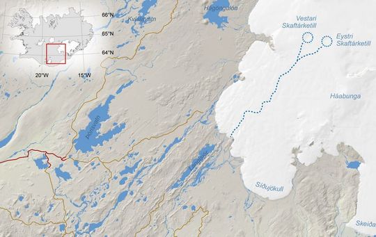
Iceland Met Service map of Skaftá River and jökulhlaup source.
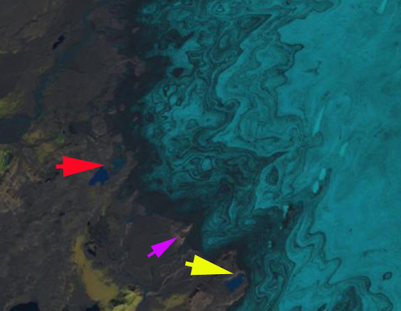
The glacier terminates at 800 m, and has a snowline since 2000 averaging 1300 m. Like many of the glaciers draining the Vatnajökull the glacier experiences periodic surges. Surging is a short term, several months to several years, acceleration and the associated advance of a glacier that is not primarily dictated by changes in mass balance or climate. A surge is related to a change in the basal water pressure that in this region is related to volcanic activity. The glacier surged in 1920, 1945 and 1995, that latter surge led to an advance of 1175 m in 1995. From 1955-1970 the glacier retreated at a rate of 75 m/year. From 1973-1992 the glacier retreated 1400 m. The surge led to an advance of 1175 m in 1995 bringing the glacier back close to its 1973 position. Since then the glacier has continued to retreat. Tungnaarjökull terminus is surveyed each year and the data reported to the WGMS. From 1996-2000 the glacier retreated 80 m. From 2001-2010 the glacier retreated 640 m. Below is the margin of the glacier indicating the moraine from which the glacier receded after the 1945 surge, the 1995 surge did not emplace a moraine. A comparison of Landsat images from 1999 and 2014 illustrates the retreat. Note the expansion of the lakes and the formation of a new one at the red and yellow arrow. The exposure of new moraine ridges at the purple arrow also indicates retreat.

1999 Landsat image
2015 Landsat image
The mass balance of this glacier has also been measured since 2000. During that period the glacier has had a negative balance every year, 12 of the 13 years the mass balance loss has been larger than 0.8 meter of water equivalent. The total loss for the period of 15 m, will lead to continued retreat. This is a substantial thinning of the glacier, but a small part of the total volume given a glacier that averages more than 500 m in thickness. The equilibrium line has been high since 2000, leading to only 40% of the glacier being snow covered at the end of the summer. on a glacier like this that lacks avalanche accumulation due to its low and consistent slope at least 60% of the glacier must be snow covered to have an equilibrium balance this would be 1150 m. This height is close to the elevation midpoint of the glacier.
Beyond the terminus the retreat is exposing a large relatively flat plain that is rich with glacial geologic deposits, many linear examples are evident. These features are streamline features from glacier flow. The retreat here is similar to the Bruarjokull on the north side and Skeidararjokulli on the west side of the Vatnojokull.
Retreat of Glacier d’Argentiere, France
Glacier d’Argentiere flows 9 km northwest towards the valley of Chamonix, France just north of Mont Blanc and one valley north of the Mer de Glace. The glacier retreated 1000 meters from 1870-1967. The first picture below provided by Richard Hodgkins to the PAGES project shows a century of change. Below that is the 2009 terminus view in Google Earth. The terminus is quite crevassed indicating considerable velocity. It is currently at the top of a steep slope that it has retreated up in the last five years. 
 From 1968-1985 the glacier advanced 300 m. Since 1985 the glacier has been retreating at an increasing rate: 80 meters from 1991-1995, 187 meters from 1996-2000, 199 meters from 2001-2005, data is not in for the 2006-2010 period but the retreat is in excess of 200 meters. The retreat has been triggered by sustained negative mass balance. A mass balance program on d’Argentiere was begun in 2004, the glacier lost 1.3 m in 2004, 1.9 m in 2005, 1.4 m in 2006, 0.7 m in 2007, 1.3 m in 2008 and 2.6 in 2009. That is a cumulative mass balance loss of 9.2 meters of water equivalent lost from the glacier in six years, and that is a 10-11 m loss in average ice thickness from the glacier. The recent rapid retreat and mass balances losses parallel those of the other glaciers in the Alps from which data is reported to the WGMS. The reason for the mass balance loss is evident from the Google Earth imagery of August, 2009. The snowline, shown in lime green, is at 3300 meters on south facing slopes and at 2900 meters on north facing slopes and the main valley of the glacier, this is one month left in the melt season. At this point the glacier is 35-40% snowcovered and will be less by the end of the melt season.
  To be in equilibrium a glacier must have 60% snowcover at the end of the summer. From 2004-2009 the average snowcovered area at the end of the melt season was 30%. The tributary glaciers draining the south facing slopes of the valley have lost all their snowcover in 2005, 2006 and 2009. This is leading to a diminished contribution to the mainstem of the Argentiere.
  This will foster continued retreat. A view across the glacier in August 2008 from Jürg Alean indicates the meager snowcover on the south facing glaciers and the main glacier tongue.
Imja Glacier Retreat and Imja Tsho Lake expansion, Nepal
The Imja Glacier is in the Khumbu Range of Eastern Nepal’s Himalaya, just
southeast of Mount Everest. The glacier drains the east slopes of Lhotse, south slope of Penghatse and west slopes of Baruntse before flowing past the southern slope of Island Peak to terminate at Imja Tsho glacial lake. Imja Tsho formed after 1960 due to glacier retreat and is continuing to expand today.
 According to Fujita and others (2009), the lake in 2008 is 1.1 kilometers long and has an area of 0.9 km2 and a volume of 37 million cubic meters. Bajracharya and Mool (2009) observed that Imja Glacier itself retreated at a rate of 41 meters/year from 1961-2000 and 74 meters/year from 2001-2006. The terminus ends in the expanding lake and is heavily debris covered.
  A study by ICIMOD (The International Centre for Integrated Mountain Development, 2008) documented that all 22 glaciers observed in the Dudh Khosi Basin have retreated since 1976 with the minimum retreat being 10 meters/year and the maximum 59 meters/year
The Imja Glaciers is two valleys east of the more famous Khumbu Glacier which has been retreating at a slower rate of 15-20 meters/year. Imja Glacier like its neighbors can be divided into four key sections that each have a different mass balance impact and climate sensitivity.
1)Debris Covered Zone-The portion of the Imja Glacier comprises 35-40% of the glaciers area. The debris cover if thin can enhance melting, but in most area the debris cover is thick enough to insulate the glacier and reduce melting. The debris is brought down onto the glacier by avalanches and accumulates at the surface as the snow and ice the debris mingles with is melted away. This area has plenty of debris and is not impacted by black carbon deposition.
2)Transition Zone-this is the zone between the debris cover and the dry snow accumulation zone. This zone encompasses the snowline which is 5400-5600 meters on Imja Glacier. This is zone of bare ice and snow that experiences melting and can be impacted by black carbon deposition. On Imja Glacier this zone comprises 15 to 20% of the glacier’s area.
3) Avalanche slope zone. There are many unglaciated slopes that are a mixture of rock and snow. They are too steep to hold sufficient snow to form a glacier and most snow cover avalanches onto the glacier below. Though not part of the accumulation zone of the glacier, these slopes are a key feeder to the glacier. Since the avalanches relocate snow from high elevation to low elevation they are a key feature that makes Imja Glacier susceptible to precipitation at elevations above 5500 meters.
4) Accumulation zone-This is a dry snow zone above 5800 meters of perennial snow cover. The snow is dry indicating the lack of melting. A unique aspect of the Himalayan glaciers on the southern flank of the range is that the melt season coincides with a principal accumulation season of the summer monsoon. The summer monsoon causes nearly daily snowfall from June-August that is retained above 5800 meters. The new snow prevents the glacier from being susceptible in this area to black carbon deposition. In the image below the debris covered zone is outlined in purple, the snowline in the transition zone is shown in lime green, accumulation areas are outline in blue and the entire area that feeds the glacier is outlined in dark green. The areas that feed the glacier, that are not part of the glacier do so by avalanching.
The lake is of concern since the moraine that dams it is not stable. It can melt down and erode slowly or it can lose height more quickly resulting in a glacier dammed lake outburst. The level of the lake has been relatively constant in recent years, but is monitored to forecast this potential hazard. ICIMOD has collected satellite images of the lake expansion from 1962-2008. 
White Glacier Retreat, Olympic Mts. Washington
White Glacier descends the Northwest flank of Mount Olympus in Olympic National Park in Washington. The glacier had a very large retreat from its Little Ice age maximum to 1952 of 3200 meters (Heusser, 1957). At that time it was joined with its more famous neighbor Blue Glacier, which is also retreating today. From 1958-1980 the glacier advanced a small distance, the 1950 based map of the area shows the terminus location of the glacier at that point. The burnt orange line indicates the map terminus, the forest green line the 1990 terminus. The Blue Glacier advanced nearly 200 meters in this interval
 By 1990 the glacier had retreated 100 meters from its recent advance position. From 1990-2006 retreat accelerated averaging 12 meters per year, 315 meters total. The Blue Glacier has retreated nearly the same distance, 300-325 meters since its maximum position in the 1980’s. In the image below from 2006 the retreat since 1990 is evident, what is also striking is the sections of the bedrock ridge between the two termini outlined that is emerging from the glacier. The White Glacier will become two distinct glaciers separated by this rock ridge as retreat continues.
  The retreat is ongoing as the lack of crevassing near the current terminus indicates. This is despite a fairly steep slope. The rock rib that is beginning to separate the White Glacier is also visible below. The terminus today is at 1400 m, the head of the glacier at 2000 m.
  The high elevation of the upper glacier has allowed it to retain snowpack even in recent warm summers when other glaciers in the area, Anderson and Fairchild, lost all their snowcover. This will allow this glacier to endure current climate.
Heusser, C.J., 1957. Variations of Blue, Hoh and White Glaciers during recent centuries. Arctic, 10(3), 139-150.
Spicer, R.C., 1989. Recent variations of Blue Glacier, Olympic Mountains, Washington, USA. Arctic and Alpine Res., 21(1), 1-21.
Thiel Glacier Alaska ongoing retreat
Thiel Glacier is a valley glacier in the Juneau icefield of Alaska. The glacier was a tributary of the Gilkey Glacier and is shown as such in USGS maps. From 1948-2005 the glacier has retreated 2100 meters from its former junction with the Gilkey Glacier. Below is the USGS map of the area showing the junction of the Battle, Gilkey and Thiel Glacier. The same view from the 2005 Google Earth imagery indicates the separation of the three glaciers and the emergence of a new deglaciated valley section. 
 In 1984 looking down at the glacier from its highest elevation, it was clear that the glacier had too small of an accumulation area to support the long, low elevation valley tongue of the glacier. From that vantage I could not see the terminus. The snowline at the end of the summer typically is at 4000-4500 feet at the end of the melt season, leaving only 45% of the glacier in the accumulation zone. For a glacier to be in equilibrium at least 60% of the glacier needs to be in the accumulation zone. The upper margin of the glacier is outlined in blue and the snowline indicated with blue arrows in the image below.
  The current glacier terminus is stagnant and the retreat is ongoing. At the terminus a close examination of the 2005 imagery forth indicates a series of concentric crevasses at the terminus. Such crevasses typically are the indicative of a collapse feature. Usually it is a subglacial lake that drains that had supported the terminus to some extent. Above this point the ice is stagnant lacking tranverse crevasses that would indicate movement. The surface of the glacier has a rough cross profile as a result without active movement to even out the profile. Areas of debris generally are prominent as the debris is insulating the ice underneath.
  The 2005 terminus is at 650 feet, compared to the same location in the USGS maps of 1500 feet. This nearly 900 feet of thinning is depicted by the surface wall overlay added to Google Earth, the top of this wall is at 1500 feet. In the foreground is the Gilkey Glacier which the Thiel formerly joined and the new deglaciated valley.
 This glacier will continue to retreat rapidly with the current climate much like the nearby Hoboe Glacier and Tulsequah Glacier and Lemon Glacier
Methods for assessing and forecasting the survival of North Cascade, Washington glaciers
This paper was just published, Methods for assessing and forecasting the survival of North Cascade, Washington glaciers. It represents the third in a series of papers that looks at methods to identify when an alpine glacier will not survive. The first paper was using the change in thickness along a profile up the center of the glacier. Glaciers that were thinning appreciably and similarly along their entire length were determined to be in disequilibrium and would not survive. The second paper looked at glaciers that experienced thinning in the accumulation zone as distinguished by emergence of bedrock outcrops, marginal recession in the accumulation zone and overall accumulation zone thinning. Glaciers that were thinning in the accumulation zone were forecast to not survive. In this paper the model is expanded to look at the percentage of a glacier that is snowcovered at the end of the melt season. This is the accumulation area ratio. Typically a glacier needs to be 60% snowcovered or more at the end of the melt season to have an equilibrium balance. If the glacier has an AAR of less than 30% frequently, those glacier have been noted as thinning appreciably in the accumulation zone and will not survive. To survive a glacier must of course have a persistent accumulation area, as snow is the income of the glacier. A glacier that lacks such a zone, then has only a melt zone-ablation zone, and only liabilities and will go out of business. Lets look at three glaciers that exemplify this issue. The first and third are forecast not to survive current climate, the middle glacier will. The first is Lynch Glacier the pictures are from 1960 and 2007, in the upper left of the glacier-the accumulation zone, you can note the emergence of bedrock outcrops, Point B. This indicates that snowcover is not persisting and this has become a melt zone even though it is near the head of the glacier. The second is Easton Glacier. This glacier descends the south side of Mount Baker. Even in the years with the poorest snowcover, such as 2009 the glacier remains snowcovered to the end of the summer over the upper third of the glacier. This image is from mid-Sept. 2009, mid-Sept. 2010 was a much better year.
 The last glacier is Foss Glacier which shows considerable shrinkage in the upper reaches of the glacier, what should be the accumulation zone, here the glacier is seen in 1985 and 2005.
  .
. 
 Also notice the lack of an accumulation zone in 2005. This was the case that summer on Columbia Glacier (above) and Ice Worm Glacier (below) as well. 2003, 2004 and 2009 were other years in which accumulation was not retained on many North Cascade WA glaciers. The picture of Ice Worm Glacier contrasts the glacier from 2005 to 2009. The picture indicates more retreat at the top of the glacier at Point A.
Castle Creek Glacier, BC annual retreat recorded
Castle Creek Glacier is in the Cariboo Mts. of British Columbia. The glacier descends north-northeast for 6.3 km from 2825 meters to the terminus at 1,810 meters. During the last 50 years of retreat has left a series of annual terminal recessional moraines that indicate how much the glacier has retreated each year. The glacier has a remarkably uniform and relatively low slope for an alpine glacier. This is one feature that helps ensure that the retreat rate changes little from year to year as the glacier flow dynamics are consistent. There is no prominent icefall, there is no low slope terminus tongue that can stagnate. The extent of the glacier during the Little Ice Age is quite evident as the gray vegetation free zone. 
 Castle Creek Glacier has receded every years since 1959 at total of 720 meters up to 2008, about 14 meters per year. The Universtiy of Northern Brictish Columbia as part of the Western Canadian Cryosphere Network has undertaken a detailed investigation of this glacier. Matt Beedle at UNBC has been the field leader for the project, and has had the chance to map and identify the annual recessional moraines. The three pictures below are from Matt Beedle. The first is a series of aerial photographs that have been cropped to show the same area. Note that in 1946 the glacier filled the view, by 2005 it barely makes the image. The period from 1971 to 1991 has the most notable recessional moraine ridges. Beyond the 1967 margin there are at least 10 moraine ridges
The recessional terminal moraines are not unusual features to be formed by a retreating glacier, however they are unusual to be formed each year and to be so well preserved. The recessional moraines are deposited on a till plain exposed by the glacier retreat. Often such moraines are ice cored and tend to disappear as the ice core melt outs, not the case here. The moraines form during the winter when the glacier continues to move and the terminus is not melting. In summer after the terminus area is exposed the terminus melts back. The Key as pointed out by Matt Beedle is summer temperature. Such moraines will not form on a glacier with a stagnant glacier tongue. Such moraines also do not form on glaciers that have a terminus area that is an avalanche runout zone that can bury the terminus some years.

The glacier fits the pattern of glaciers throughout the southern interior ranges of BritishColumbia and Alberta which Blch et al (2010) noted lost 11% and 25% of their area over the period 1985–2005 respectively.
Midtdalsbreen Glacier, Norway retreat Continues in 2010
The Norwegian Water Resources and Energy Directorate is the most extensive national glacier monitoring program in the world. They noted in 2010 that 27 of 31 glaciers monitored retreated. Midtdalsbreen near Finse drains the eastern portion of the Hardangerjøkulen (Hardanger ice Cap).  This glacier retreated 34 meters from 2009 to 2010 and has retreated 143 meters in the last 10 years. This retreat is less than the retreat of Rembesdalsskaka Glacier which drains west from the Hardangerjokulen and has retreated 311 meters in the last decade. The 2010 Image below indicates the area beyond the terminus that is quite fresh and lacks any new vegetation as yet, the small hillocks and ridges are ice cored. The debris has not stabilized yet. The terminus is quite lacking in crevasses and the slope modest, suggesting the retreat will be ongoing.
  Beyond the current margin are a series of low moraines some of them forming annually with no retreat from October-May and then summer retreat.
  Moraines like this tend to be ice cored when formed and are prominent. The moraine is really a 20-50 cm or debris overlying a core of dirty ice. Once this ice melts years later the once obvious moraines are hardly noticeable. The terminus of the glacier is well defined. The upper section of the glacier that drains the ice cap lacks clear margins. The ice cap generally does retain snowpack throughout the summer season, continuing to feed the glacier outlets. The reduction in the area and depth of this seasonal snowpack by summers end leads to less outflow from the ice cap through the outlet glaciers and hence terminus retreat.
Llaca Glacier Retreat, Peru
The Cordillera Blanca, Peru has 27 peaks over 6,000m, over 600 glaciers and is the highest tropical mountain range in the world. Glaciers are a key water resource from May-September in the region, Mark (2008). The glaciers in this range have been retreating extensively from 1970-2003, GLIMS identified a 22% reduction in glacier volume in the Cordillera Blanca. Vuille (2008) noted that the retreat rate has increased from 7-9 meters per year in the 1970’s to 20 meters per year since 1990. One of the glaciers that is continuing to recede is Llaca Glacier descending the west slopes of Ranralpaca. This glacier has retreated 1700 m from its Little Ice Age moraine, outlined in lime green. Llaca Laguna is impounded by this moraine. The glacier still has a significant consistent accumulation zone and can survive current climate.
  Stagnant pockets of debris covered ice no long connected to the glacier fill much of the valley between the laguna and the current glacier. The terminus despite ending on a steep slope lacks significant crevassing indicating a lack of vigorous flow which will lead to continued retreat of 20-30 meters per year.
  This glacier drains into the river which then flows into the Rio Santa in Huarez, Peru. Mark (2008)note the importance of glaciers to the Cordillera Blanca watersheds in the Huarez region receive 35% of their runoff from glaciers, and the upper Rio Santa likely receives 40%.
