Kanchenjunga Glacier, Nepal High Snowlines Expanding Supraglacial Ponds in 2023

Screenshot

Kanchenjunga Glacier in Nov. 8, 2023 false color Sentinel image.  The flowlines of the six tributaries shown in green with the snowline on each at the purple dots. Percentage of glacier length above the snowline for each tributary shown as percentage. Two rapidly expanding supraglacial lakes shown at yellow arrows.

Kanchenjunga Glacier is the main glacier draining west from Kanchenjunga Peak draining into the Ghunsa River. Lamsal et al (2017). report a loss of -0.18 m/year from 1975-2010. They noted an increase in supraglacial ponds and that the glacier had decreased in thickness mainly between the terminus and 5500 m, with some thickness increases above 5850 m. The Kanchenjunga Region has produced 6 to 8 GLOF’s since the late 1960’s, but none from the Kanchenjunga Glacier which had lacked substantial proglacial or supraglacial lakes until now (Byers et al 2020). Here we examine Sentinel imagery indicating the high snowline in November 2020, January 2021 and November 2023.

Screenshot

Kanchenjunga Glacier in Jan,. 17, 2021 false color Sentinel image.  The snowline on each at the purple dots. Percentage of glacier length above the snowline for each tributary shown as percentage. Two rapidly expanding supraglacial lakes shown at yellow arrows.

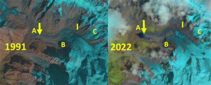
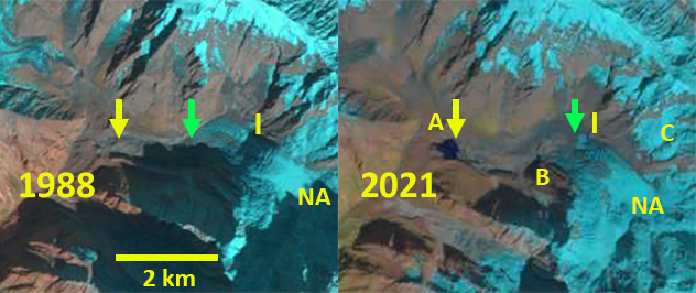
A glacier needs a majority of its area to be in the accumulation zone to maintain its mass balance. In November 2020 the transient snow line averages 5800 m. By January 17, 2021 the snowline has risen to an average of 5950 m. Measuring the distance from the terminus to top of the glacier along the six main tributaries, and determining the percentage of this length above the snowline in the accumulation area, from 8-14% of the length is the accumulation area. This leaves a limited accumulation area. The January 2021 period had an unusually high snowline due to heat wave in January, that led to high snowlines on Mount Everest as well (Pelto et al 2021). In November 2023 the snowline averages 5900 m across the six tributaries, ranging from 10-17% of the length of the tributaries being above the snowline, mcuh too little to maintain equilibrium. The yellow arrows indicate one noteworthy change near the terminus the growth of new supraglacial ponds. The upper pond expanded from 20,000 m² in Nov. 2020 to 80,000 m² in Nov. 2023, the lower pond consisted of three discrete segments with an area of 50,000 m² in Nov. 2020 to 120,000 m² in Nov. 2023. These are the largest supraglacial lakes to appear on this glacier in the last several decades at least. These two ponds have a greater combined area than all ponds on the glacier in 2010 which Lamsal et al (2017) reported as 0.16 km². At that time the largest pond was 30,000 m².

Screenshot
Screenshot

Kanchenjunga Glacier terminus area supraglacial ponds in Nov. 8, 2023 false color Sentinel image.  Each has more than doubled in size in last three years, with areas of 80,000 and 120,000 m².

Screenshot
Screenshot

Kanchenjunga Glacier in Nov. 10, 2020 false color Sentinel image.  The snowline on each at the purple dots. Two rapidly expanding supraglacial lakes shown at yellow arrows.

North Annapurna Glacier, Nepal Retreat and Lake Development

North Annapurna Glacier in August 2022 Sentinel image. A=North Annapurna Base Camp, I=icefall base,  B= Prominent Knob, C=tributary that has separated by 2022. The green arrow marks the end of the active ice which is now 1.5 km upglacier of the terminus. Note Diki Cho (lake) is relatively free of icebergs that were plentiful in 2018.

North Annapurna Glacier drains the northeast side of Annapurna (8091 m). The North Annapurna climbers base camp (NABC) for the original ascent in 1950 was opened to trekking in 2020 via the new Maurice Herzog Trail. The NABC is located near the terminus of the North Annapurna Glacier, when first located there was no lake at the terminus of the glacier. Today glacier thinning and retreat has led to development of DikiCho. The glacier has also become stagnant in its lower reaches. Here we examine Landsat imagery from 1988-2022 to identify the long term changes, and Sentinel imagery from 2018-2022 along with trekking images from 2020-2021 to look at the lake development in details.

North Annapurna Glacier in 1988 and 2022 Landsat images.   Yellow arrow indicates 2022 terminus location. A=North Annapurna Base Camp, I=icefall base,  B= Prominent Knob, C=tributary that has separated.

In 1988 North Annapurna Glacier extended to the end of what has become Diki Cho (lake) and into the main north/south valley of the Miristi Khola. The tributary at Point C connects to the glacier above the icefall. The area of active blue ice extends 1.5 km beyond the icefall, including a series of ogives. The only evident change is the increase debris cover below the icefall. In 2001 the first sign of a lake at the terminus is evident and active blue ice extends beyond Point B. By 2018 Diki Cho has expanded to an area of 0.15 km² and has considerable stranded icebergs amidst the lake.  The area of active ice ends just below Point B.  By 2021 most of the ice amidst Diki Cho has melted. Tributary C no longer connects to the main glacier and the zone of blue ice extends just beyond the base of the icefall. The wam summer of 2022 led to further lake expansion particularly along the southern margin of the glacier, with an area of 0.27 km². The lower 1.5 km of the glacier is stagnant. North Annapurna Glacier has retreated 600 m from 1988-2022. The lower 1.5 km of the glacier is no longer being actively fed by the glacier and will be lost, though with thick debris cover this will not happen quickly. This section of the glacier also has a low surface gradient indicating that lake expansion will continue. The retreat here has been slower than at Lumding Glacier or Barun Glacier, but is increasing in the last decade.

North Annapurna Glacier in 1991 and 2022 Landsat images.   Yellow arrow indicates 2021 terminus location and green arrow the end of the blue ice. A=North Annapurna Base Camp, I=icefall base,  B= Prominent Knob, C=tributary that has separated.

North Annapurna Glacier in August 2018 Sentinel image. A=North Annapurna Base Camp, I=icefall base,  B= Prominent Knob, C=tributary that has separated. The green arrow marks the end of the active ice which is now 1.5 km upglacier of the terminus. Note Diki Cho has many icebergs.

Annotated image of Diki Cho from near the North Annapurna Base Camp, image from Nepal Trek Hub.

North Annapurna Glacier in 2001 Landsat image.   Yellow arrow indicates 2021 terminus location and green arrow the end of the blue ice. A=North Annapurna Base Camp, I=icefall base,  B= Prominent Knob, C=tributary that is separating.