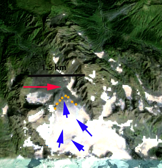
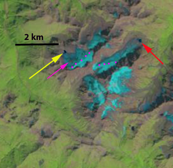
Luge and Thorthormi Glacier drain south from the border with China into the Pho Chu River in Bhutan. Both glaciers end in expanding glacier lakes that are prone to outburst floods, which sweep down the Pho Chu. Osti et al (2012) reported in detail on the nature of these floods, noting there are eight dangerous lakes including the two at the terminus of Lugge and Thorthormi Glacier, Thorthormi Cho and Lugge Cho. In 1994 Lugge Cho experienced a glacier lake outburst flood GLOF which incurred huge damage in the Pho Chu basin. The 1994 GLOF event had a peak discharge of about 2539 cubic meters/s and extended 200 km downstream as a flood wave Osti et al (2012) . The GLOF occurred after rapid retreat of Lugge Glacier from 1988-1993 of 160 m/year. 
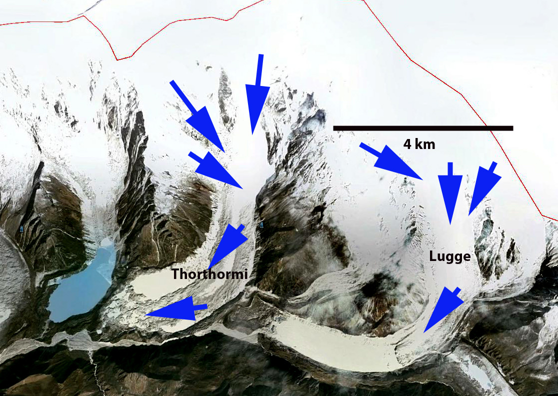
Google Earth Image
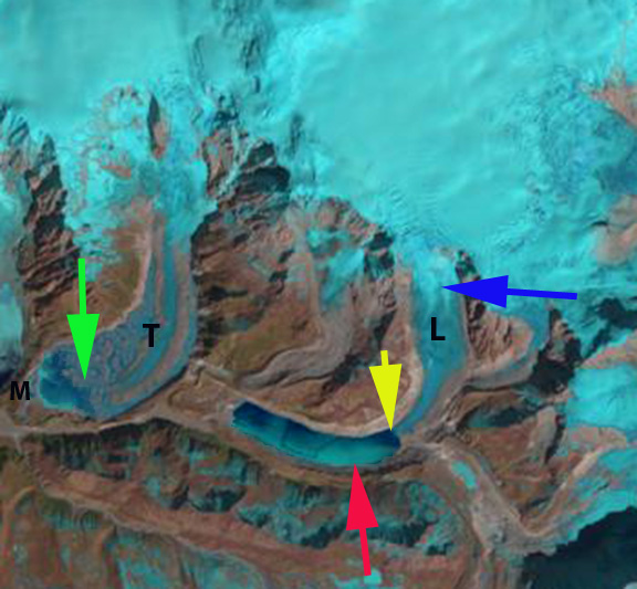
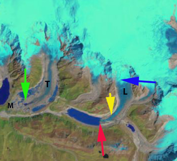
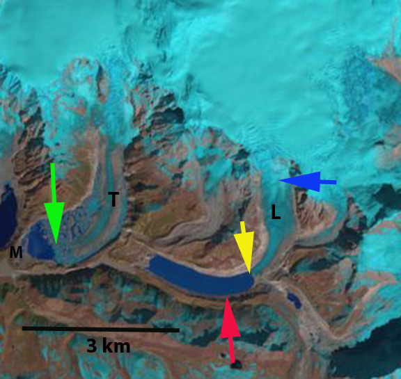
Here we examine the retreat of both glaciers in Landsat imagery from 2000-2014. In each image the red arrow indicates the 2000 terminus, the yellow arrow the 2014 terminus, the blue arrow the snowline on Lugge Glacier and the green arrow the center of the Thorthormi Glacier terminus in 2013. In 2000 the Lugge Glacier ends in a 2 km long Lugge Cho. The Thorthormi Glacier has pockets of proglacial lake in 2000, but also a debris covered terminus that extends across the lake basin to the Little Ice Age moraine (M). The two images from 2000 are from the start of October and late December. Note the snowline remains near 5100-5200 m in both images. The glaciers of Bhutan are summer accumulation type glaciers, in which the main accumulation season is during the summer monsoon. The snowline tends to rise from October into December with limited snowfall. By 2013 Lugge Glacier has retreated 1 km from the 2000 position, and Lugge Cho is now 3 km long. The terminus of Lugge Cho is not stagnant and it is not clear how much longer the deep basin extends under the glacier. If the basin does not extend much further retreat will soon be reduced. Thorthormi Glacier debris covered terminus connection to the moraine (M) has melted away and a lake extends across the full width of the glacier basin. The contiguous lake now has an area of over 1 square kilometer. The retreat of Thorthormi has been 700 m since 2000. The lowest 1 km of the glacier is stagnant and melt should be enhanced by calving into the lake, hence the retreat should remain quick in the next decade. The snowline in the Late November 2013 and early February 2014 image indicate the snowline at close to 5300 m in both. The retreat of these glaciers is leading to expansion of proglacial lakes much like the nearby Theri Kang and many other across the region Changsang Glacier, Sikkim, Lumding Glacier, Nepal Matsang Tsanpo, Tibet .
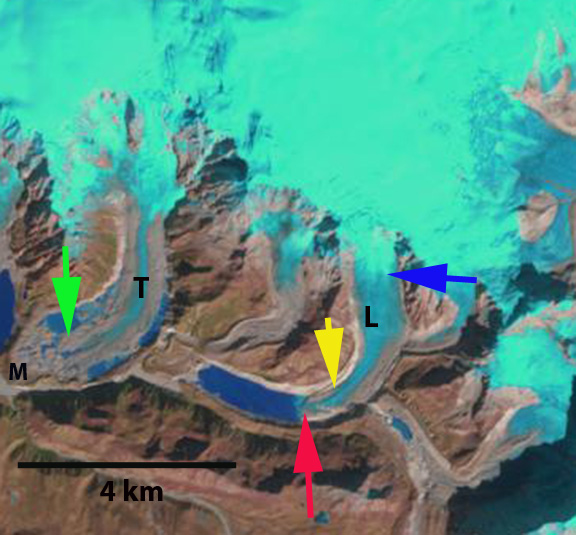
2000 Landsat image
2000 Landsat image
Kangiata Sermia, Retreat Southwest Greenland
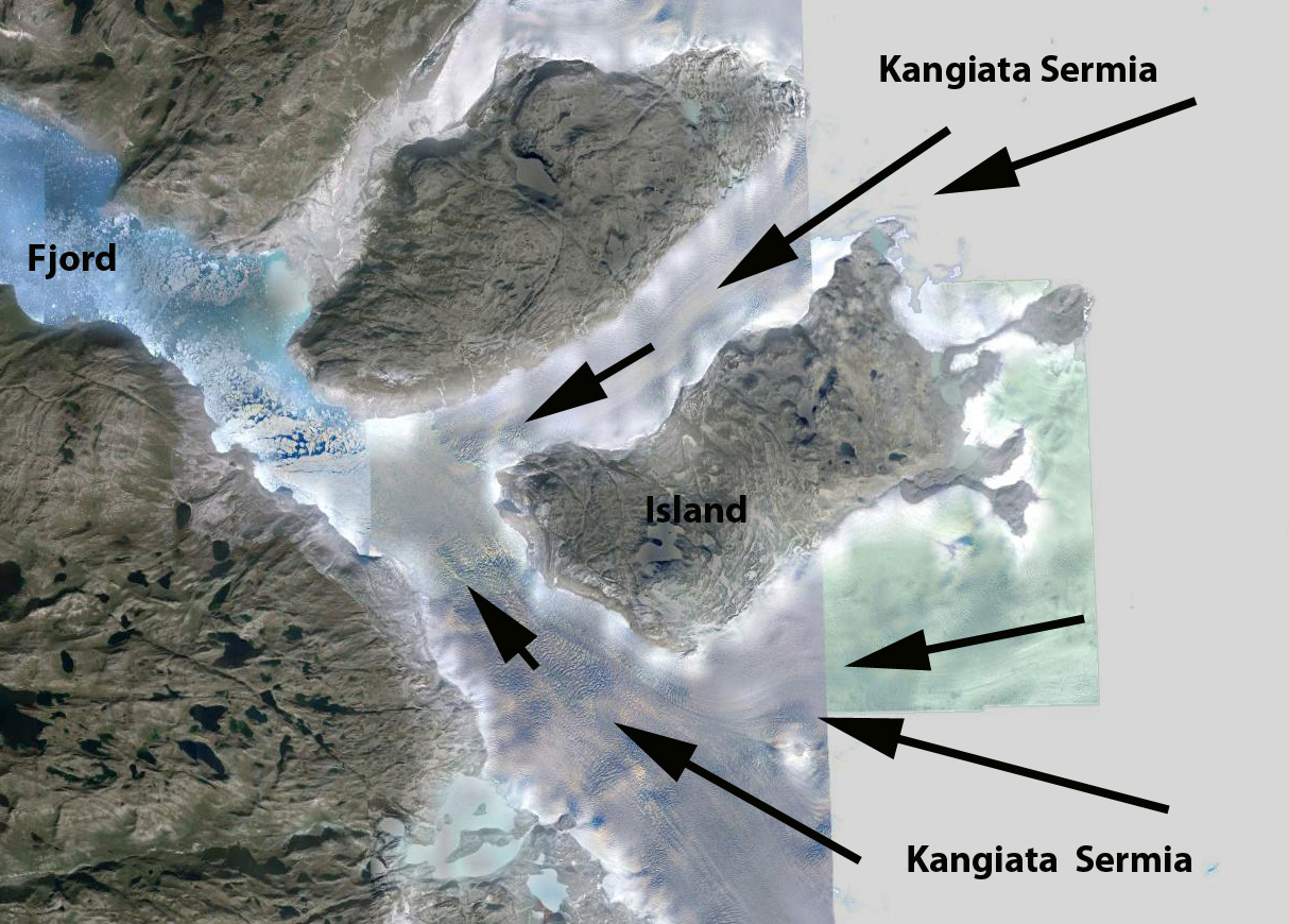
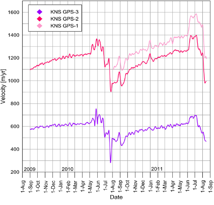
Kangiata Sermia is an outlet glacier in Southwest Greenland that empties into the Kangersunaq fjord east of Nuuk. Thomas et al (2009) noted that Kangiata Glacier thinned most notably near its terminus decrasing up glacier to negligible thinning 30 km inland. They further found that the glacier bed was above sea level 40 km inland. Sole et al (2010) observed variations in the velocity of this glacier and found that there was a substantial spring speedup as the melt season began and then an even more significant slowdown for most of the summer. They noted that the net effect of the summer speed variations on annual motion is small (∼1%), indicating the lack of a meltwater induced overall acceleration. The velocity figure below is from Figure 4 of Ahlstrom et al (2013), indicating the annual velocity minimum is in late summer. Box and Decker (2011) noted that glacier retreated 100 meters/year from 2000 to 2010.

Google Earth image

Thomas et al (2009) Figure showing the bedrock and surface profile of Kangiata Sermia

Ahlstrom et al (2013) Figure showing seasonal velocity change of Kangiata Sermia
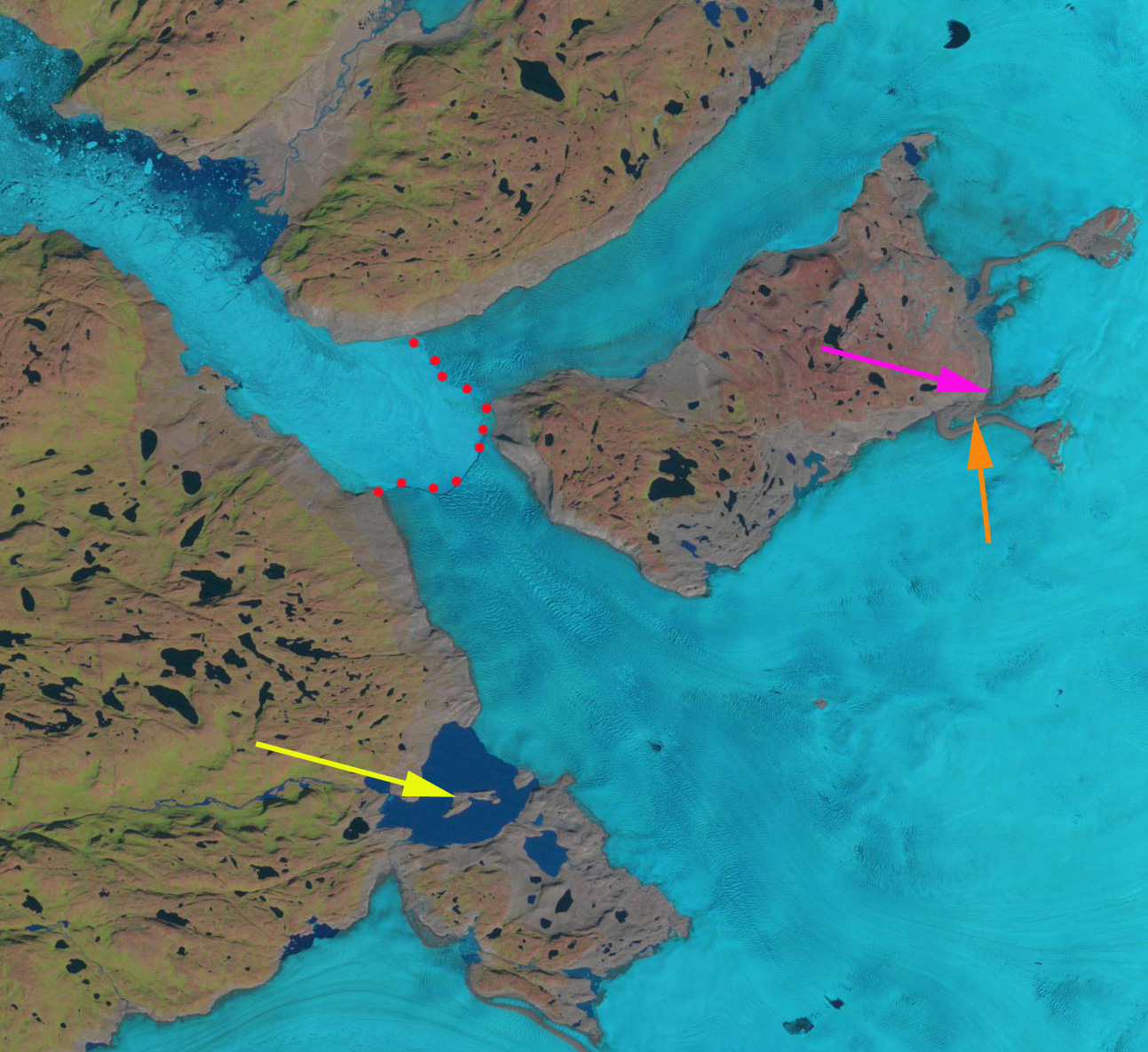
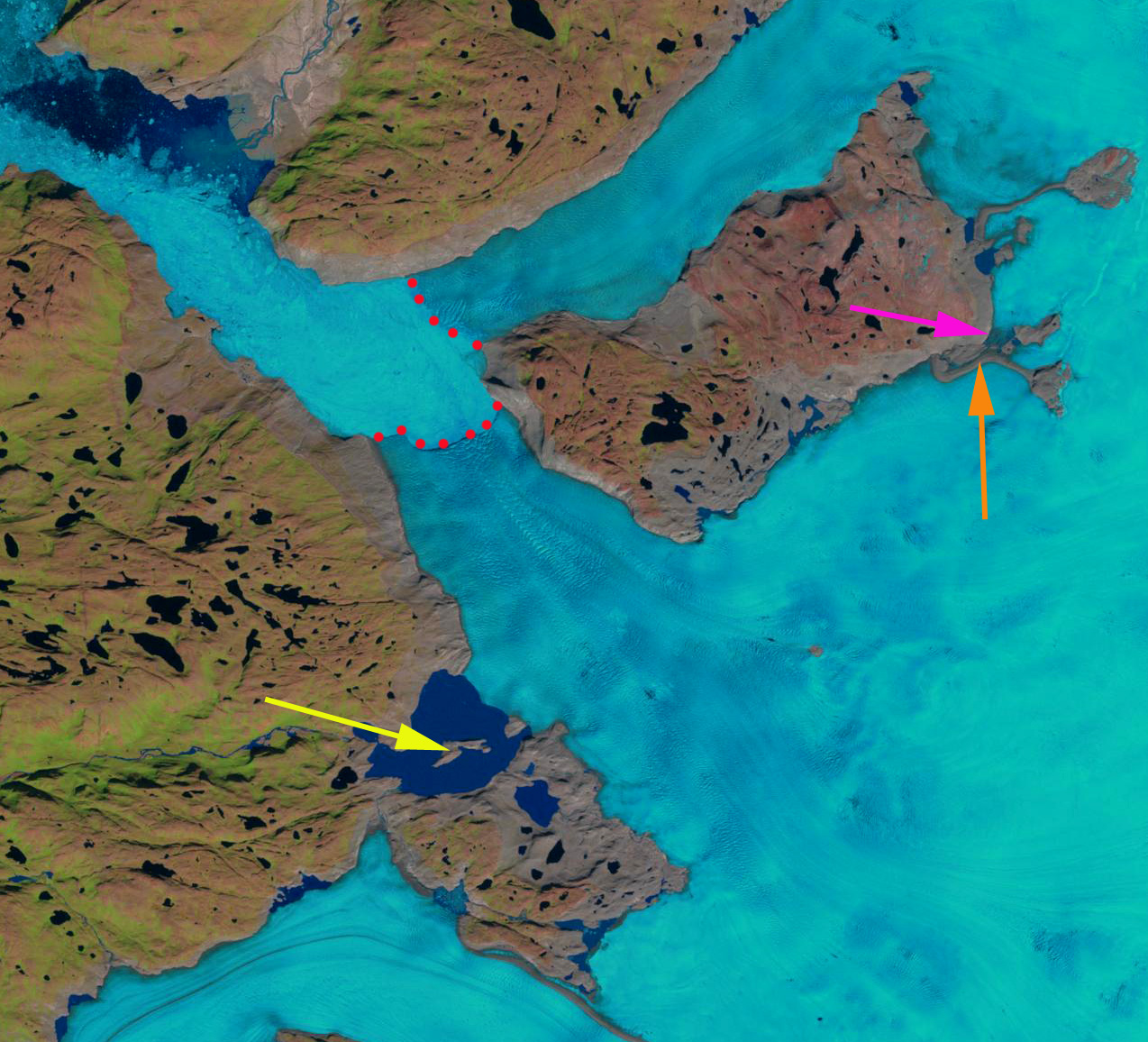
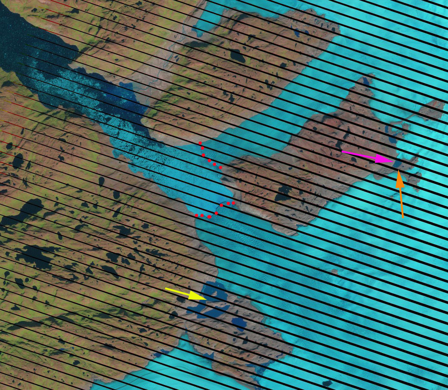
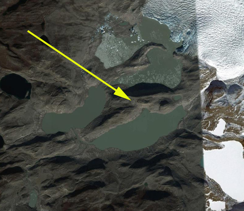
Here we examine Landsat imagery of the glacier from 1987 to 2013 to identify changes. In 1987 the two main termini of the glacier were joined, down fjord of an island that separates the two branches. The terminus in each image is indicated by red dots, the yellow arrow note an island in the middle of a peripheral ice dammed proglacial lake, the pink arrow a minor terminus on the north side of the island and the orange arrow a medial-lateral moraine comples extending into the glacier. By 2001 the glacier terminus has separated into two parts, with a retreat of jsut over 1 km in the 14 years. The proglacial lake is still full, yellow arrow. The upglacier minor terminus is developing a lake at its terminus as it retreats. The orange arrow indicates the expansion of the moraine complex as the glacier thins. By 2006 the main terminus has continued to retreat up the south side of the island 1.5 to 2 km since 2001. The proglacial lake level has declined and the island has become a peninisula. The thinning ice is simply not able to impound as deep or large a lake. The minor terminus at the pink arrow has developed a lake that is over 1 km long. In 2013 the changes from 2006 are limited, the moraine complex has continued to expand. The overall retreat from 1987 to 2013 is 3 km. The retreat is similar to that of Narssap Sermia , Kuussuup Sermia, and Qaleraliq as each responds to the climate warming. The lake is a bit larger, though the lake does fluctuate through an annual cycle filling and draining. Google Earth imagery indicates the lake at an even lower level, it no longer fills to nearly the level of 2001. This lake is similar to Tiningnilik in its size and location, but has lost more of its volume. The lake at the pink arrow is 1.2 km long. Each winter the fjord in front of the glacier freezes and the terminus protected from calving can advance. The Google Earth closeup image indicates the heavily crevassed nature of both termini indicative of rapid flow. On April 2, 2014 the fjord is quite filled with sea ice to the southeast bend 50 km from the terminus. The terminus is not distinct in this particular image. 
1987 Landsat image

2001 Landsat image

2006 Landsat image
Khatling Glacier Retreat, Uttarakhand, India
Khatling Bamak (Glacier) is the headwaters of the Bhilangana River in Uttarakhand, India. The Bhilangana River flows into the Tehri Reservoir(2400 MW), that along with the Bhilangana River’s three small hydropower projects (50 MW), make these glaciers key contributors to regional hydropower. The glacier was formerly joined with the Ratangrian Glacier as indicated by the map, but the two have separated with the Ratangrian Glacier now terminating 1.7 km upvalley of this former connection. The 10 km long glacier is fed by several mountain peaks including Jaonli over 6000 m. The lower section of the glacier is debris covered. 
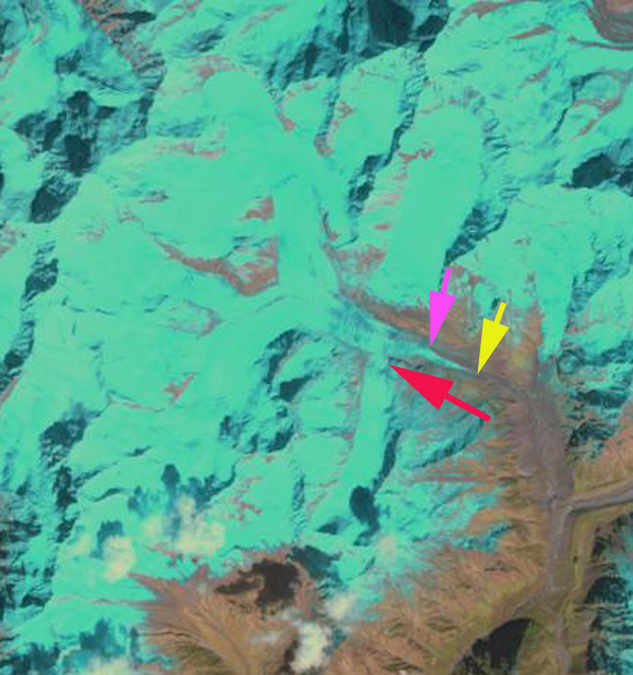
Here we examine satellite imagery from 1998, 1999, 2011 and 2013 to identify recent changes. The yellow arrow in the images indicates the lower limit of the clean ice in 1998, the pink arrow the lower limit of the clean ice in 2013. The red arrow indicates a significant tributary to Khatling Glacier joining from the south. The terminus is not evident in the Landsat images, but can be observed in the Google Earth imagery.
In 1998 the southern tributary joins the Khatling Glacier at 4500 m, 2.5 km upglacier of the terminus. The clean ice extends to within 1 km of the terminus. In the 1999 image the same connection with the southern tributary and location of the clean ice is evident. By 2011 the southern tributary is no longer connected to the glacier, red arrow. The clean ice does not reach the yellow arrow. The spread of the debris cover is not from additional avalanche input or flow from upglacier. The spread occurs as a glaciers ablation melts the clean ice faster and the debris cover where thick slows ice melt. This leads to topographic highs covered by debris cover that than slide-tumble down onto the clean ice. Without much input from upglacier the debris within the ice is melted out and can continue to concentrate at the surface. This is common among retreating glaciers with debris cover to have the debris begins to spread across the glacier. By 2013 the clean ice extent has retreated 1000 m from 1998 to the pink arrow of 2103. The southern tributary has retreated 200 m from its former junction. The terminus of the glacier has retreated 400 m from 1998-2013. A close up of the terminus from 2011 Google Earth imagery indicates the outlet river (pink arrow) issuing from beneath the stagnant debris covered ice (DC) and the distance from the terminus to the clean ice (CI). The lateral moraines of the Khatling and Ratangrian Glacier are also shown. The hummocky thin nature of the lower 700 m of the glacier is evident, light blue arrows, indicating an area that will be lost from the glacier soon. Khatling Glacier retreat is similar to that of nearby Gangotri Glacier and Jaonli Glacier that also feed Tehri Dam.

1998 Landsat image
Ratangrian Glacier Retreat, Uttarakhand, India
Ratangrian Glacier is adjacent to Khatling Glacier and with that glacier is at the headwaters of the Bhilangana River. The Bhilangana River flows into the Tehri Reservoir(2400 MW), that along with the Bhilangana River’s three small hydropower projects (50 MW), make these glaciers key contributors to regional hydropower.

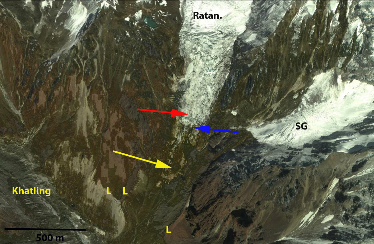
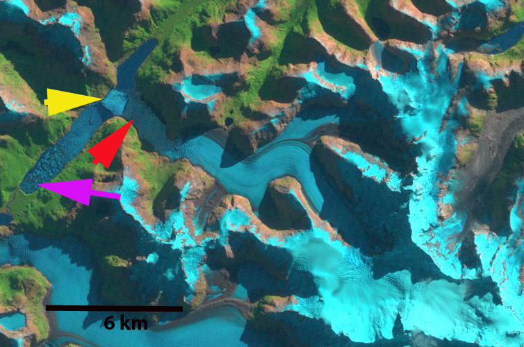
In the 1998 Landsat image the glacier terminus is at the red arrow, which is at 4150 m and downhill of the stream from the glacier labelled SG. The map above indicates the glacier was joined with Khatling Bamak at 3950 m, the lateral moraines (L-on second image below) indicate this too. The glacier is quite steep in its last mile descending from 5000 m to 4150 m in 1.5 km. The glacier is also not debris covered unlike many of its neighbors Khatling, Gangotri or Jaonli Glacier. A 2011 Google Earth image indicates the glacier has retreated to the blue arrow, where the outtlet stream from the glacier SG reaches the Ratangrian valley. By 2013 the glacier has retreated above the location where the outlet stream reaches the valley and is at the yellow arrow. The total retreat in 15 years is 400-450 m. The terminus of the glacier has risen from 4150 m to 4500 . The glacier is following the path of retreat of the nearby Gangotri Glacier and Jaonli Glacier that also feed Tehri Dam. The retreat is more rapid proportionally for the size of the glacier, probably due to the lack of debris cover. The slopes in the basin feeding the glacier are mostly covered by the glacier itself. If they were steeper and were not as ice covered, than avalanches could sweep debris onto the glacier.
1998 Landsat image
Verde Glacier Retreat, Chile
Verde Glacier is adjacent to Reichert Glacier and drains the north side of the Northern Patagonia Icefield. It is a small glacier compare to many outlet glaciers of the icefield that have been examined in previous posts, Reichert Glacier, Steffen Glacier, Nef Glacier, and Colonia Glacier. Here we examine Landsat imagery during the 1998-2014 period to identify the response of the glacier. The glacier flows from a pair of peaks at 1800 m to terminate at the edge of a proglacial lake. There is a significant icefall at 800-1250 m and a significant avalanche fan at the base of this icefall that is spills from a disconnected portion of the glacier west of the terminus and just northwest of the icefall. Davies and Glasser (2012) Figure 2d indicates the glacier nearly filling the entire lake in 1975. In Figure 8a they indicate the fastest retreat for the glacier being from 1998-2014. Rivera et al (2007) indicate the ELA for the glacier at the top of the icefall 1250 m. 
The yellow arrow in each image is the 2014 terminus and the red arrow the 1998 terminus. In 1998 the glacier terminates at the red arrow just beyond the northeast bend in the lake. The lake is 1.6 km long. By 2001 the glacier has retreated 300 m and is at this bend. Notice that the lowest lone kilometer of the glacier is quite debris covered. By 2014 the glacier has retreated to the yellow arrow, this is a further 600 m retreat since 2011. The lake is 2.5 km long measured along its center line. The 900 meter retreat in 16 years is substantial for a glacier that is only 5 km long. A cloe up view of the terminus in a Goggle Earth image indicates that the lowest 300 m is debris coverered ice, notice the wetness of some of the debris, pink arrow. This looks more like ice cored moraine than active glacier ice covered by debris. If this is the case the active terminus is 300 m from the shore of the lake, at the yellow terminus where calving begins. It is certain the lake will expand further as the buried ice melts, but it is nearing its southwestern limit. The steep slope of the icefall and the rock slope to the right of the icefall is evident. This will lead to continued avalanching onto the terminus area, that will make that lowest region above the yellow arrow more difficult to melt out. One observation that is striking is the number of narrow alpine lakes that have formed and expanded as the Northern Patagonia Icefield outlet glaciers have receded. 
1998 Landsat image
Reichert Glacier Rapid Retreat, Northern Patagonia Icefield, Chile
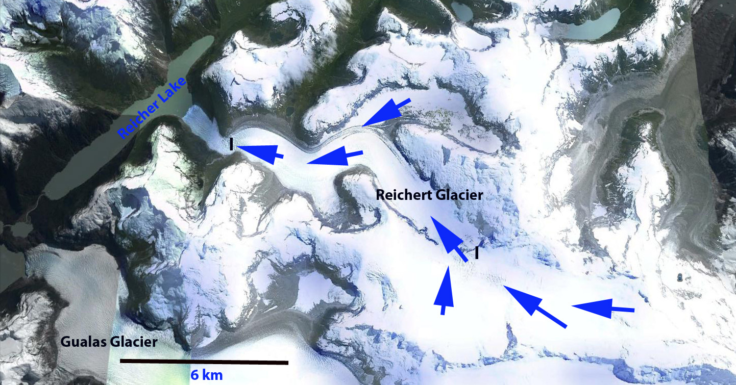
Reichert Glacier (Reicher) is at the northwest corner of the North Patagonia Icefield (NPI) and flows west from the Mont Saint Valentin region and ends in the expanding Reicher Lake. Rivera et al (2007) notes that the glacier was named for French geologist Federico Reichert, but that Reicher has ended up as the established spelling. They further note that the glacier lost 4.2 square kilometers of area from 1979 to 2001 and had an ELA of 1330 m. The glacier has two main icefalls, one at the first bend in the glacier above the terminus at 400 m, the second at the ELA from 1100-1600 m. Davies and Glasser (2012) identify the most rapid area loss of -0.77% per year to the 1986-2001 period. The glacier retreated rapidly from 1987-1997, but the terminus was stabilized from 1997-2001, before retreating again to near the 2014 terminus by 2002.

2013 Google Earth image
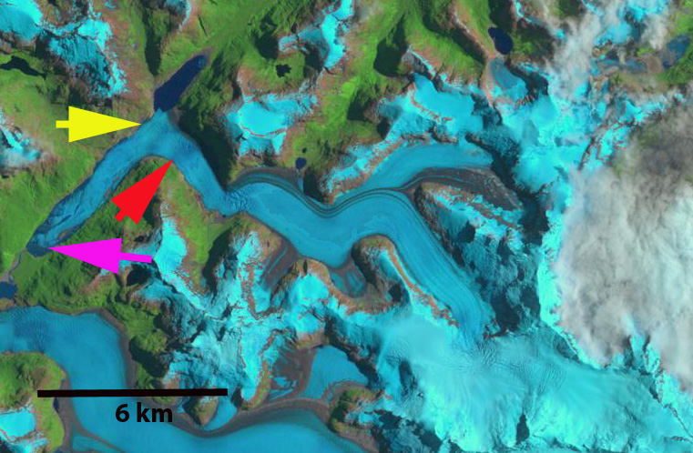
Here we examine Landsat imagery from 1986, 1997 and 2014 to document the changes. The pink arrow indicates the 1987, terminus, the yellow arrow the 1998 terminus and the red arrow the 2014 terminus. In 1987 the glacier terminates close to the southern end of Reicher Lake, pink arrow. By 1998 the glacier has retreated to the yellow arrow and is terminating on the west side of Reicher Lake across the lake from the main glacier valley. By 2014 the glacier has retreated into the main glacier valley and Reicher Lake extends 8.8 km from the northeast to southwest. A new lake has developed in 2014 above the first icefall, orange arrow. This lake indicates a potential second lake basin beginning to develop in the glacier reach above the first icefall. If this is the case another rapid retreat will ensue, though not in the immediate future. The glacier retreated 6.7 km from 1987 to 2014, with 90% of the retreat occuring by 2002. Area extent loss is 8-9 square kilometers. The lower icefall is 1.5 km from the current terminus, and indicates the maximum extent of Reicher lake and the retreat that can be enhanced by calving into that lake. This glacier has followed the pattern of the neighboring Gualas Glacier just to its south. WHOI-Oceanus recently published an interesting article on this glacier. The retreat is emblematic of the entire NPI as noted by both Rivera et al (2007) and Davies and Glasser (2012) work, the latter had an excellent Figure 8 indicating two periods of fastest recession since 1870, are 1975-1986 and 2001-2011 for NPI glaciers. This retreat includes that of Steffen Glacier, Nef Glacier, and Colonia Glacier.
Heaney Glacier and Cook Glacier Retreat, South Georgia Island
Heaney Glacier and Cook Glacier were merged near the terminus and reached the coast of St. Andrews Bay on the east coast of South Georgia Island in 1975. This is illustrated in a Geomorphology map of the area compiled by Chalmers Clapperton, and David Sugden produced with the support of the British Antarctic Survey, the glaciers terminates along the coastline.
Photograph of 1980 BAS map
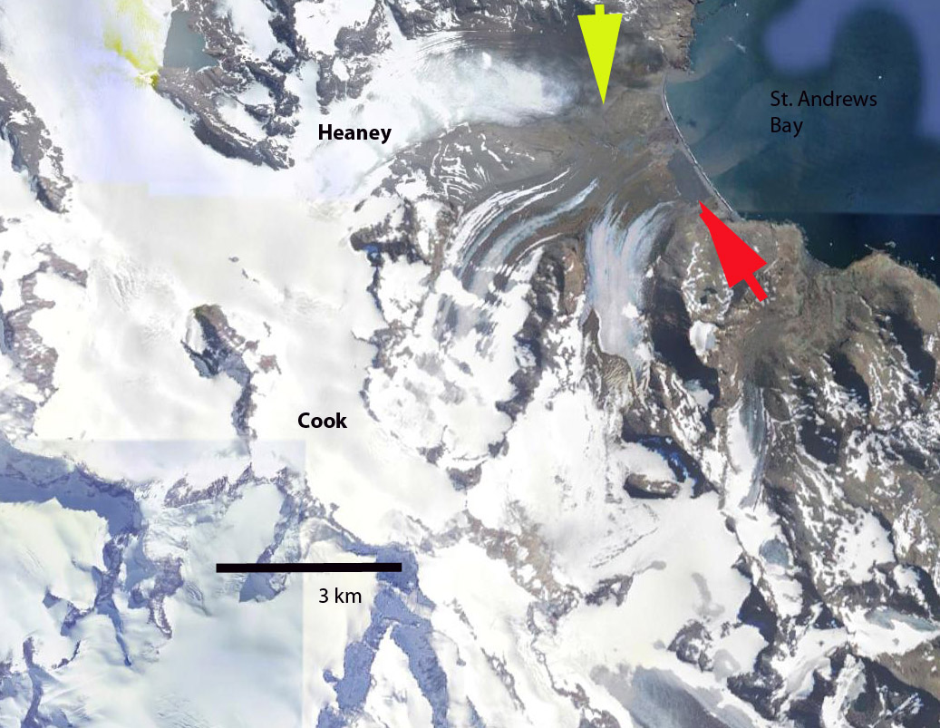
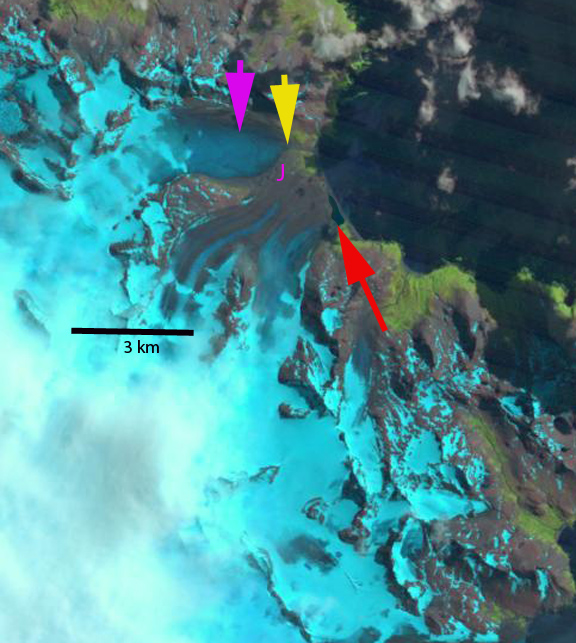
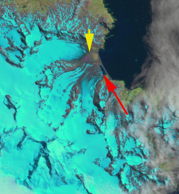
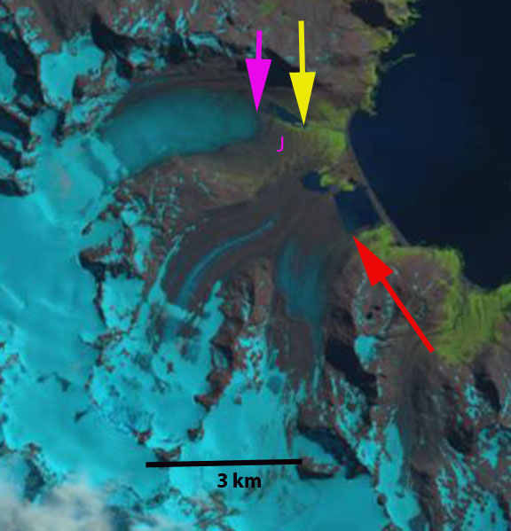
Here we use Landsat images to examine glacier change from 1989 to 2014. In 1989 Cook Glacier had retreated from the coast, and a small 200-300 m wide proglacial lake has formed at the end of the glacier, red arrow. The yellow arrow marks the 1989 terminus of Heaney Glacier in 1989 which is 800 m from the coast, pink arrow indicates 2014 terminus position. Point J marks the junction of the two glacier which is debris covered ice in 1989. The next image in 1999 indicates modest retreat of both glaciers. In 2003 Cook Glacier has retreated 500 m from the coastline, and Heaney Glacier is now 1100 m from the coast. In 2012 a small lake is developing at the front of the Heaney Glacier and the Cook Glacier proglacial lake has expanded to 700 m. In 2014 the narrow lake forming as Heaney Glacier retreat’s is now 600 m long and the glacier terminus is 1800 m from the coast, pink arrow. This is an 1000 m retreat from 1989 to 2014, 40 m/year. Point J is now fully deglaciated with Cook and Heaney Glacier being fully separated. Cook Glacier has retreated 900 m from the coast and 600-700 m since 1989. The proglacial lake, red arrow is 750 across and is still expanding as the glacier retreats. The story at this point is familiar with that of other land terminating glaciers on South Georgia Island, Konig Glacier and Purvis Glacier, with substantial accelerating retreat and lake formation at the terminus. Cook et al (2010) and Gordon et al (2008) have emphasized that this pattern is island wide with many calving glaciers having faster retreat.
1989 Landsat image
Purvis Glacier Retreat, South Georgia Island
Purvis Glacier is on the norteastern coast of the island, terminating on land near Possession Bay. The British Antarctic Survey (BAS) has mapped many aspects of the island including glacier front changes. Their mapping indicated below shows that the Purvis Glacier terminus was on the coastline in 1974. Here we examine Landsat imagery from 1999 to 2014 to identify more recent changes. Cook et al (2010) quantified the change in these maps noting that 97% of the 102 coastal glacier retreated between the 1950’s and today.

BAS map of Glacier change.
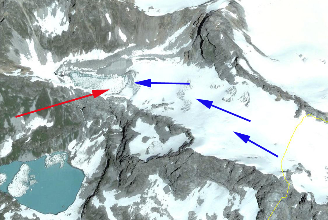
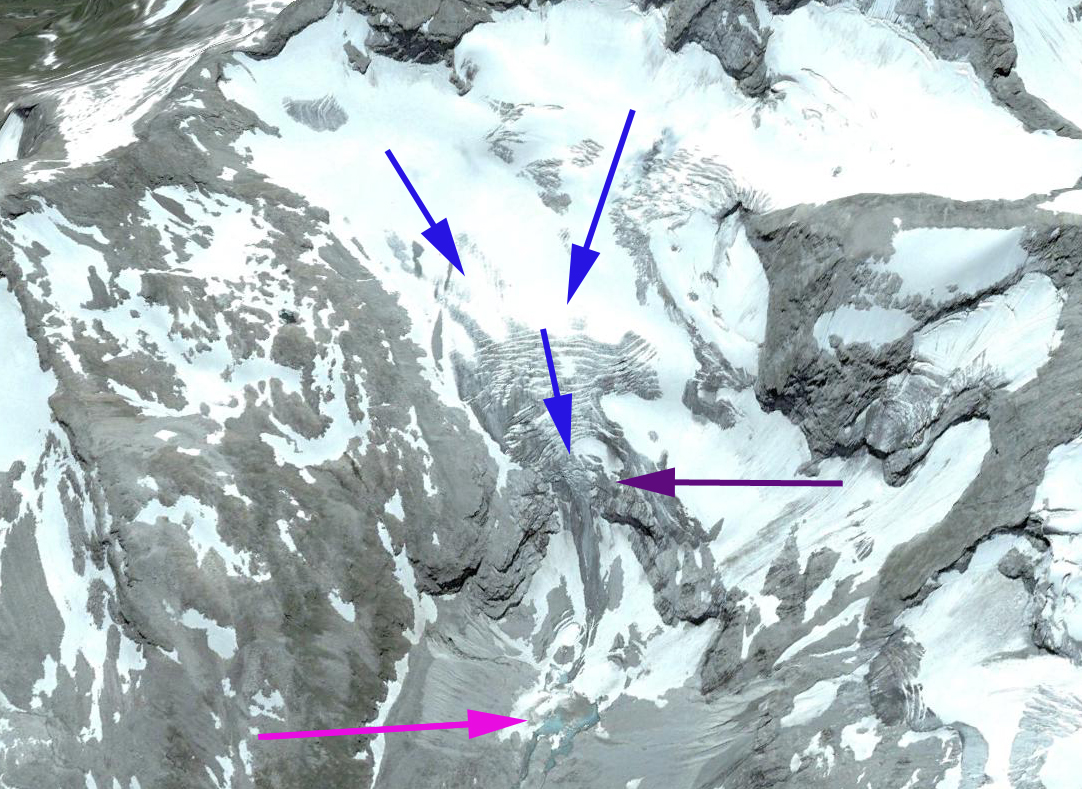
In 1999 the proglacial lake, red arrow, that the glacier terminated in was 300 m wide, indicating a retreat of 300-400 m since 1974. By 2002 the proglacial lake had expanded to a width of 600 m, exposing a peninsula at Point A. By 2013 the proglacial lake had expanded to 1050 m, further exposing the peninsula at Point A. By March 1, 2014 Landsat imagery indicates a retreat of 1100 m since 1974, with most of that retreat occurring since 1979. A closer look at the glacier from Google Earth highlights the issue. The glacier is fed by relatively low lying snowfields with quite limited areas above 500 m. Sugden, Clapperton and I in a 1989 paper identified the snowline a short distance from here at 400 to 450 m. As the 2011 Google Earth image indicates the remaining snowcover at the end of the melt season is minimal, too little to sustain this glacier (Pelto, 2010). Further a look at the terminus indicates the stagnant nature of the terminus region that will lead to continued retreat, blue arrows note ablation holes in the glacier that do not develop when a glacier is actively moving. The low slope and stagnant nature should preserve an excellent glacial geologic landscape.
The glacier is behaving in the same fashion as other land terminating glaciers Heaney Glacier and Konig Glacier. The retreat is less than that of calving glaciers on the island Neumayer Glacier and Ross-Hindle Glacier.

1999 Landsat image
Konig Glacier Retreat, South Georgia Island
Konig Glacier is a land terminating glacier just north of the Neumayer Glacier, ending on an outwash plain in the Antarctic Bay (AB) on the northwest coast of South Georgia. In 1977 the glacier extended to within 300 m of Antarcic Bay and no proglacial lake existed (BAS map). Neumayer Glacier is a calving glacier that has retreated 4800 m from 1999 to 2014 and is dynamically connected to the Konig Glacier along its southern margin just where the glacier turns northeast. Gordon et al., (2008) observed that larger tidewater and sea-calving valley and outlet glaciers generally remained in relatively advanced positions until the 1980s. After 1980 most glaciers receded; some of these retreats have been dramatic and a number of small mountain glaciers will soon disappear.
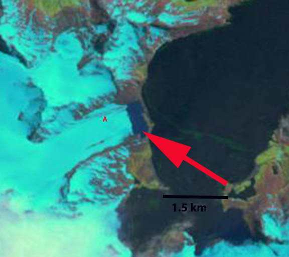
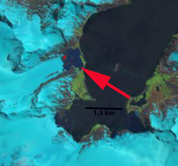
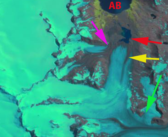
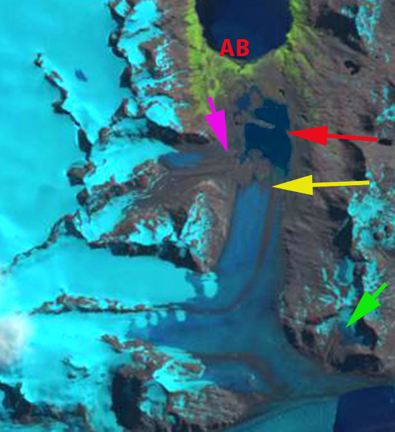
Here we examine changes in Konig Glacier from 1999 to 2014 using Landsat imagery. In 1999 the glacier ended in a proglacial lake at the red arrow, where a terminal moraine developed across the lake. A tributary glacier from the west joins the Konig Glacier near the terminus in 1999, pink arrow. At the green arrow is a small cirque-valley glacier that joins the Neumayer Glacier near the boundary with Konig Glacier. In 2003 there has been limited retreat of the main terminus since 1999 and of the west tributary at the pink arrow, the British Antarctic Survey mapping shows that the two glacier had separated by 2003. The side cirque glacier at the green arrow is still connected. By 2005 a closeup of the terminus in Google earth indicates the low slope, lack of crevasses and developing outwash plain at the terminus. The terminal moraine in the middle of the lake marking the 1993 terminus position is also evident (BAS). The retreat from this moraine by 2005 is 500m. In 2014 the glacier has retreated from to the yellow arrow, this is an 800 m retreat in 15 years from the 1999 red arrow terminus. The proglacial lake is now 1500 m across and the terminus is 2300 m from Antarctic Bay. The west gtributary at the pink arrow is fully separated. The side cirque glacier at the green arrow no longer is connected to the Konig-Neumayer Glacier. This indicates considerable thinning of the junction of these two glaciers which will result in further retreat of Konig Glacier.

1999 Landsat image

2003 Landsat image
Kluhor Glacier Retreat, Caucasus Mountains, Russia
Kluhor (Klukhor) Glacier is in the Caucasus Mountains west of Mount Elbrus. It drains into the Teberda River and then the Kuban River and eventually Krasnodar Reservoir and the Black Sea. The Krasnodar Reservoir is primarily a flood control and irrigation management reservoir. Here we examine three glaciers each experiencing the familiar pattern in the Caucasus Mountains of retreat with expansion of proglacial lakes. As the area and number of glacier is reduced, the number and area of alpine lakes is increasing, note Khimsa Glacier, Georgia, Psysh Glaciers, Russia, and Gora Bashkara, Russia. Stokes et al (2006) note that 94% of Caucasus Mountain glaciers retreated from 1985 to 2000 and it is clear from the aforementioned that the trends continues.

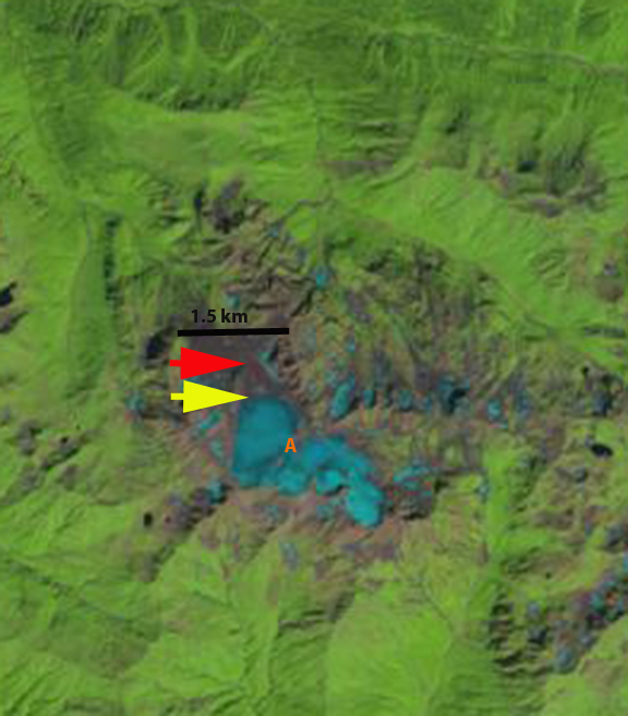
We examine Landsat imagery from 1998 and 2013 to identify the change. In each image the Kluhor Glacier terminus lake is indicated by the red arrow. The unnamed Glacier here named east Kluhor Glacier terminus lake is noted with a yellow arrow. Another unnamed glacier on Lednik Daut is identified here as north Daut Glacier is noted by pink and purple arrows. In 1998 there is small lake at the end of Upper Kluhor Glacier, 150 m long, and on east Kluhor Glacier, 50-100 m wide. At north Kluhor Glacier the glacier ends at the base of a steep icefall near a third lake, pink arrow. The purple arrow indicates the terminus of north Daut Glacier in each image. By 2013 Kluhor Glacier has retreated 300 m and the lake is 450-500 m long. The east Klhor Glacier has retreated 150 m and the lake is 250 m across. The north Daut Glacier has retreated to the top of the steep icefall slope, a 400 m retreat and is now quite distant from the lake below.
The 2007 Google Earth image of Kluhor Glacier there are a number of crevasses paralell to the ice front, indicating that some calving losses will continue to occur. The glacier overall extends from 2950 m to 3250 m, is narrow and has limited snowcover in both satellite images. The snowcover extent in the August satellite images, well before the end of the melt season is 30%, whereas typically 55-65% is necessary to sustain a glacier. In the 2007 Google Earth imagery the thin nature of the icefall at north Daut Glacier is evident, that has since melted away.

1998 Landsat image
Khimsa Glacier Retreat, Georgia
Khimsa Glacier is a rare significant glacier south of the main crest of the Caucasus Mountains in Georgia. The glacier drains north to the Bzyb River, and then the Black Sea. The rivers upper reach is quite undeveloped and there is no hydropower along the river to date. The glacier flows from an elevation of 3000 m to 2650 m. In 1998 the glacier was 1.6 km long with a narrow terminus at the red arrow. At the transition to the glacier’s upper eastern slopes at Point A, there is only one small rock exposure. By 2013 the glacier has retreated 400 m to the yellow arrow, having lost 25% of its length in 15 years. The area of bedrock exposed on the upper eastern slope, at Point A, is significant now indicating thinning even high on the glacier. The glacier will soon separate near Point A into an upper and a lower section. In the Google Earth image the current terminus is indicated with orange dots and the glacier flow with blue arrows. Like Psysh Mountain glaciers 25 km north Khimsa Glacier thinning high on the glacier indicates it cannot survive current climate. Caucasus Mountain glaciers are in a period of rapid retreat (Shagedenova et al, 2009), that is attributed mainly to rising summer temperatures. Khimsa Glacier’s retreat parallels that of glaciers along the main crest of the Caucasus such as Kirtisho or Azau Glacier, though as a percent of total area lost it is greater.
2010 Google Earth image
Psysh Glacier Retreat, Western Caucasus, Russia
Psysh Mountain is in the western Caucasus just north of the Georgia-Russia border. This is the western most significant glacier complex in the Caucasus, here we focus on a glacier flowing east from the mountain and another on the north side. The east flowing glacier drains into the Psysh Valley and then to Arkhyz, while the north flowing glacier drains into the Zagedan River. The Caucasus region has been experiencing widespread significant retreat (Shahgedanova et al 2009), with average retreat of 8 m per year due in large part to increased summer temperatures. The larger glaciers of Mount Elbrus tend to garner most of the attention, but the retreat is widespread. This region has been an area of increased proglacial lake formation as well Stokes et al (2007). Psysh Mountain is 115 km east of Sochi, Russia. The glaciers mean elevation is 3000 m, more than 1000 m above the higher elevations of the Sochi Olympic skiing venues.
Here we examine the glacier retreat in Landsat imagery from 1998 to 2013. In 1998 the two glaciers of interest on the mountain ended in incipient proglacial lakes, less than 100 m across, yellow and red arrow. By 2013 the lake at the red arrow has expanded to a length of 400 m that the east flowing glacier ends in. The lake at the terminus of the north flowing glacier is now 350 m long. This indicates a retreat of 300 m for both glaciers. The pink arrow indicates the expansion of bedrock in the midst of the north flowing glacier. In the Google Earth image the most striking feature is how little of the glacier is above the snowline. In each image the snowline is indicated with pink dots. It is evident that neither glacier has a persistent significant accumulation area. These glaciers cannot survive without a persistent significant accumulation zone (Pelto, 2010). The blue arrow in the Google Earth image indicates an icefall in the east flowing glacier. Below the icefall the glacier has a low slope and is stagnant. This basin’s extent suggests the lake can expand another 1 km. The retreat of this glacier is similar to that of Gora Bashkara Glacier and Lednik Karugom.