Bonnet Glacier, Alberta Displays Symptoms Indicative it Cannot Survive

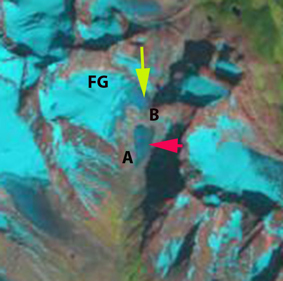
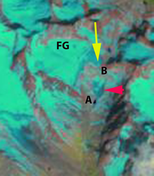
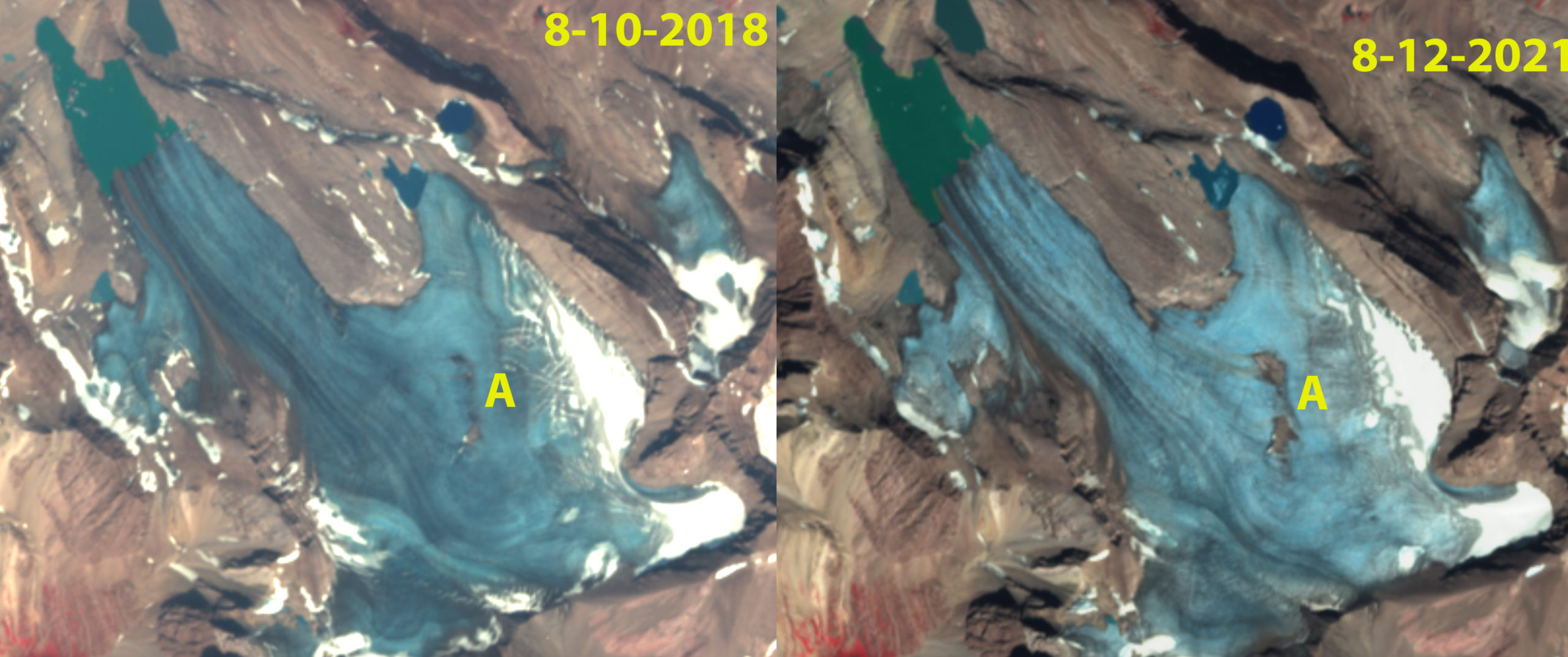
Bonnet Glacier in Sentinel 2 images indicating the emergence of bedrock due to thinning in the former accumulation zone, Point A. Note the lack of retained snowcover in both years with at least a month left in the melt season.

Bonnet Glacier, Alberta drains north from Bonnet Peak in the Sawback Range 30 km east of the Rocky Mountain Crest. It is at the headwaters of Douglas Creek that feeds into the Red Deer River.   In 2017 we reported on the formation of new alpine lakes and the 900 m retreat of the glacier, 20% of its length, from 1987-2016 (Pelto, 2017). Here we examine changes from 1987-2021, including developments in the accumulation zone that provide a future forecast. An inventory 0f glaciers in the Canadian Rockies indicated area loss of 15% from 1985 to 2005 (Bolch et al, 2010), with Alberta glaciers losing area at a higher rate.  Tennant et al (2012) noted that from 1919-2006 the glaciers in the central and southern Canadian Rocky Mountains lost 40% of their area.  Of the 523 glaciers they observed 17 disappeared and 124 separated. Columbia Icefield, 125km northwest, lost 23 % of its area from 1919-2009 (Tennant and Menounos, 2013).

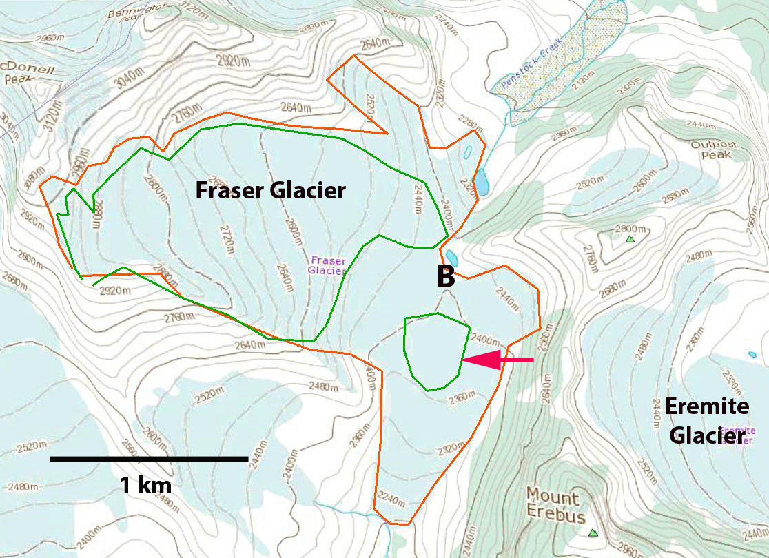
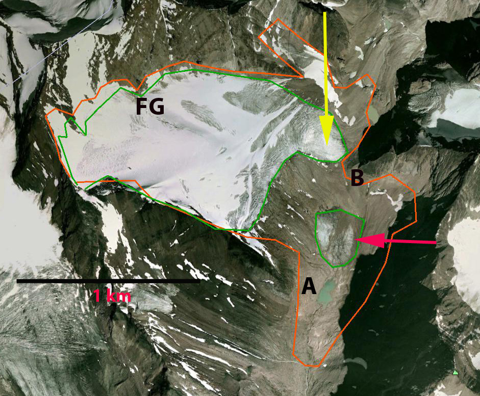
In 1987 and 1990 the accumulation zone is limited to upper periphery of Bonnet Glacier. In 2015 and 2016 the accumulation zone is restricted to the northeastern periphery.  This is indicative of a glacier without a significant persistent accumulation zone.  The consistent mass loss is driving the retreat and glacier thinning. In 2018 in the midst of what had been the accumulation zone a small area of bedrock has emerged at Point A.  By 2021 this area has expanded substantially with the two bedrock areas poised to merge soon. This thinning in the midst of the former accumulation zone is indicative of a glacier that cannot survive (Pelto, 2010). In 2015, 2018 and 2021 the accumulation area ratio was between 10-15%, a value that typically results in glacier annual mass balance of more than -2 m. The area of main proglacial expanded 50% from 2016 to 2021 to 0.33 square kilometers.

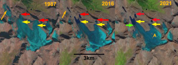
Bonnet Glacier in Landsat images from 1987, 2016 and 2021 indicating retreat. Red arrows indicate 1987 margin, yellow arrows 2016 and the green arrow 2021. Point A indicates the emerging bedrock.

Bonnet Glacier in Landsat images from 1990, 2015 and 2021 indicating retreat. Purple arrows indicate lakes that have formed due to retreat. Point A indicates the emerging bedrock.

Fraser Glacier, Separation and Retreat Alberta

Fraser Glacier, Alberta on the southern flank of Bennington Peak in Jasper National Park drains into the Athabasca River not the Fraser River. The glacier was reported in the USGS satellite image atlas as having a length of 3.5 km in the 1970’s. In Canadian Topographic maps the glacier extends for over 3.0 km from 2900 m to 2200 m. Today the glacier is barely half that length. The glacier first separated and then the lower section has now melted away. Here we use Google Earth and Landsat imagery from 1996 to 2014 to identify the changes. Bolch et al (2010) noted that from 1985-200 Alberta Glaciers lost 25% of their area. Tennant et al (2012) noted that from 1919-2006 the glaciers in the central and southern Canadian Rocky Mountains lost 40% of their area. Of the 523 glaciers they observed 17 disappeared and 124 separated, Fraser Glacier falls into the latter category.
In each image Point A indicates the same location which after 2000 a small lake develops, Point B, is the location where the glacier separated into two parts. The red arrow indicates the lower section and the yellow arrow the position of the upper terminus in 2014. In the map the orange outline is the glacier boundary on the map, while the green line is the 2005 boundary.
fraser glacier map

By 1999 the glacier has separated into two parts, but no lake exists yet at Point A. By 2002 a small lake is developing at Point A and the separation between the upper and lower glacier has increased. By 2005, a Google Earth image indicates the diminishing lower section of the glacier is 300 m long and less than 200 m wide, separated from the upper glacier by 250 m. By 2013 the lower glacier is no longer evident, there could be a small remnant of debris covered ice, but it is essentially gone. The glacier now is just 1.6 km long having lost half its length from the mapped glacier and more than half since the satellite image analysis of the 1980’s. The upper margins of the glacier have changed little and some snowpack has been retained. This suggests that now with the entire glacier in the upper basin above 2400 m, the retreat should slow down,and that the glacier can survive current climate (Pelto, 2010). The retreat of this glacier is similar to Apex Glacier, Petain Glacier, Coleman Glacier and Mangin Glacier. The retreat fits the pattern noted by Tennant et al (2012), further Jiskoot et al (2009) noted that the glaciers of the nearby Chaba-Clemenceau Icefield are experiencing faster retreat rates in recent years. All of this loss in glacier area of course means less glacier runoff, since the area lost is greater than the increased melt rate from the remaining glacier area in Alberta. fraser glacier 2005
2005 Google Earth image

fraser 1996
1996 Landsat image

fraser 2002
2002 Landsat image

fraser 2013
2013 Landsat image

fraser 2014
2014 Landsat image