Bachfallenferner, Austria: 2017 Illustrates Why Glacier is Forecast to Not Survive

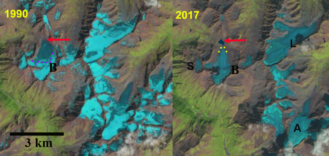
Comparison of Bachfallenferner (B) in Landsat images from 1990 and 2017.  The red arrow indicates the 1990 terminus position and yellow dots the 2017 terminus.  Note there is no retained snowcover in 2017 and a new lake has formed due to retreat. Other glaciers that lost all snowcover in 2017  L=Lisenser, A=Alpeiner and S=Sauischbachferner

Bachfallenferner is in the Stubaier Alpen, Austria.  The glacier terminus fluctuations are examined annually and reported by the Austrian Alpine Club  Fischer (2016) and Fischer (2017), with all 11 glacier in the Stubaier area retreating in 2015 and 2016.  Fischer and Kuhn (2012) surveyed the thickness of 64 alpine glaciers in Austria including Bachfallenferner, with a goal of determining volume.  They found in 2000 the glacier had an area of 2.08 square kilometers, with an average thickness of 41 m yielding a volume of .085 cubic kilometers.  

In 1990 Bachfallenferner ended on an outwash Plain at 2700 m.  The glacier was 2350 m long in 1990 with a width of 1100 m at its mid-point.  By 1999 a small sublacial lake has formed at the terminus, the lower 0.8 kilometer of the glacier is uncrevassed and relatively stagnant. In 1999 the snowcover the retained snowcover in late August covers 30% of the glacier.  In 2015 the glacier retreat has led to the formation of a proglacial lake that is 275 m across.  The glacier in late August is only 10-15% snowcovered.  By 2017 the glacier has retreated 400 m from its 1990 location including 60 m in 2015 and 2016.  More importantly the glacier by late August has lost all of its snowcover, as essentially have some of its neighbors: L=Lisenser, A=Alpeiner and S=Sauischbachferner.  A glacier that does not consistently retain snowcover cannot survive (Pelto, 2010). The glacier is now less than 2 km long and at the 1990 mid-point is 800 m wide.  Lateral recession in the lower 1 km of the glacier is similar to the rate of terminus recession.  The maximum ice thickness in 2000 was 97 m Fischer and Kuhn (2012), which is likely to have lost no more than a meter per year, hence there is still some comparatively thick ice.   The Stubaier Alpen has experienced substantial retreat in the last 30 years as have all Austrian Glaciers (Fischer et al.,2015).  Bachfallenferner is larger than most of the Austrian glaciers that are currently disappearing such as Mittlerer Guslarferner.

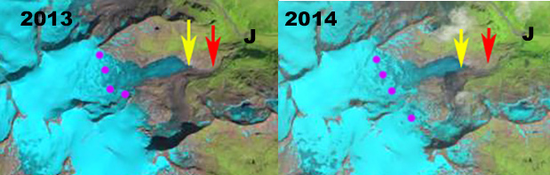
Comparison of Bachfallenferner in Landsat images from 1999 and 2015.  The red arrow indicates the 1990 terminus position and yellow dots the 2017 terminus.  Purple dots indicate snowline, not lake formed at red arrow due to glacier retreat after 1999.

Digital Globe image of Bachfallenferner in 2015. Note the lack of retained snowcover and the new lake that formed.


Schlatenkees Accelerating Retreat, Austria 1988-2016

Schlatenkees comparison in 1999 and 2016 Landsat images.  Red arrow is the 1988 terminus position, yellow arrow is the 2016 terminus location, purple dots indicate the snowline. 

Schlatenkess (Glacier) is in the Venediger Alps draining into the Innergschlöss a tributary of the Isel River. The glacier is part of the network of glaciers examined by the Austrian Alpine Club annual glacier terminus survey supervised by Andrea Fisher.  Schlaten Glacier was one of the fastest of the 97 glaciers examined in 2015 and 2016 retreating 115 m in those two years. Fishcer, (2017) report that 84 of 88 glaciers observed were in retreat during 2015, and that 87 of 90 glaciers observed in 2016 were in retreat. . Bender et al (2012) provide a photo comparison of the glacier from 1890 and 2010 illustrating the loss of glacier ice.  Here we examine Landsat and Google Earth images from 1988 to 2016. In each image the red arrow is the 1988 terminus position, yellow arrow is the 2016 terminus location, purple dots indicate the snowline and J is the Innergschlöss River junction. 

Schlaten Glacier drains east from Grossvenediger and was approximately 5.4 km long terminating at 2220 m in 1988.  The snowline in 1988 is at 3050 m.  In the 1999 Google Earth image the lower 400 m of the glacier lacks significant crevassing indicating stagnation.  In 2000 the snowline is at 3000 m. In 2013 the snowline is at 3000 m, at 3050 m in 2014, at 3150 m in 2015 and 2016.  The terminus has retreated 600-650 m from 1988 to 2016 in the Landsat images, this is 12% of the glacier length gone.  The retreat rate for this periods is ~20 m/year rising to over ~55 m/year in the last two years, which also featured highs snowlines. The glacier now terminates at 2350 m , the lower 600 m has a low slope, few crevasses and one area of concentric crevasses, indicating a basin.  The basin indicates thin ice, suggesting this section of the glacier will soon be lost.  The regional retreat has been particularly fast since 1998 as Fischer et al (2015) noted with a 20% area loss in the Venediger area.  The retreat is similar to Gepatsch Glacier and Obersulzbach Kees

Schlatenkees comparison in 2000 and 2015 Landsat images.  Red arrow is the 1988 terminus position, yellow arrow is the 2016 terminus location, purple dots indicate the snowline.

Google Earth Image from 1999, above and 2015 below.  Point A and B respectively indicate the 1999 and 2015 terminus locations. 

Terminus of Schalten Glacier in 2015 note concentric crevasses indicating a basin. 

Schlatenkees comparison in 2013 and 2014 Landsat images.  Red arrow is the 1988 terminus position, yellow arrow is the 2016 terminus location, purple dots indicate the snowline.