Hollentalferner Retreat, Bavarian Alps Germany

Hollentalferner (Glacier) is on the east flank of Zugspitze the highest mountain in the Bavarian Alps of Germany. The upper portion of the glacier is avalanche fed which flows through a minor icefall to the main terminus tongue that displays prominent annual layers.Hagg et al (2012) in a detailed examination of Bavarian Alp glaciers report on changes in the area of this glacier from 1950 to 2010. They note that from 1959 to 1981 the glacier expanded from 26 to 30 hectares. From 1989 to 2010 the glacier contracted from 30 hectares to 22 hectares. A comparison of 2000 and 2009 Google earth images indicates a retreat of the main terminus tongue of 40 m. The glacier tongue also contracted a similar amount in width. The level of crevassing on the upper glacier declined somewhat. In a closeup of the annual layers, last image, the main tongue displays 45 annual layers, red arrows. The secondary terminus, pink arrow, displays much narrower and more numerous layers. The supraglacial streams, orange arrows have incised more deeply into the glacier from 2000 to 2009. The combination of retraction of the terminus tongue, reduced crevassing and greater surface stream development on the glacier indicate a thinning glacier that will continue to slowly retreat. The crevasses in the icefall reach, green arrows, have significant depth ~10 m, and are widened by ablation processes. They indicate active flow from the upper glacier in the recent past, but the sharply concave profile below the icefall suggests limited flow into the terminus tongue area at present. The glacier retreat is less than on Blaueis Gletscher and though the glacier cannot achieve equilibrium with current climate and will disappear, this process will take longer than on the other Bavarian glaciers, this glacier will almost certainly still be around after 2030. hoellentalkar_hq
Image from Karlsruhe Institute of Technology

holleantal area
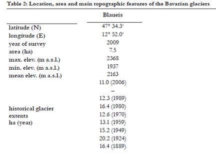
Table of areal extent change from Hagg et al (2012)

hollental 2000
Google Earth 2000

hollental 2009
Google Earth 2009

hollental annual layers
Google Earth 2009

Blaueis Gletscher Retreat, Bavaria Germany

The Blaueis Gletscher is the furthest north glacier in the Alps.  It occupies a narrow deep valley oriented north, between the summits of Blaueisspitze and Hochkalter. Hagg et al (2012) in an examination of Bavarian glaciers over the last 120 years note the changes in area of Blaueis Gletscher.  The glacier increased in area from 16 to 20 hectares during the 1889 to 1924.  Retreat from 1924 to 1970 led to a decrease in area to 12.6 hectares.  Advance in the 1970’s increased the area back to 16 hectares by 1980.  Since 1980 rapid area loss to 7.5 hectares by 2009.  This rapid loss has led to many media reports of the imminent loss of the glacier. Here we examine imagery of the glacier from 1982-2014 to identify its current status.  In 1982 the glacier consisted of the main upper reach and a thin lower ice in a photograph from R. Drescher from the Bayerische Gletscher website.  By 2005 the thin lower ice has declined in area and thickness and is not  connected to the upper glacier allowing ice transfer. There is some fringing thinner ice in 2005 on the lower margin of the upper ice.  By 2009 the thin marginal ice at the downhill end of the upper glacier, has declined and become largely detached from the main glacier.  A closeup in 2009 indicates the glacier has 45-48 annual layers of accumulation exposed at the glacier surface.  This image indicates that no recent accumulation has been retained as all of the layers are blue ice and no snow or recent firn exists on the  upper glacier.  A glacier without consistent accumulation cannot survive (Pelto, 2010).  This survival forecast method does not detail how long it will take to disappear. The number of annual layers exposed indicates the glacier thickness is still significant, further the location precludes rapid melt.  Thickness maps from 2007, from the Bayerische Gletscher group, indicate the main upper ice is 5-10 m thick, with some areas over 10 m thick, based on radio echo sounding. Based on the number of annual layers and lack of crevassing reaching the glacier base, it seems to me the average thickness is somewhat greater. Glacier’s that I have worked on develop significant crevasses that reach the glacier base as the thickness drops below 10 m. Using typical volume-area scaling coefficients suggest the average thickness to be 12-15 m. There is a webcam at the Blaueis Hut that indicates the glacier today 8/22/2014 still has substantial snowcover. With the current climate this glacier in the least exposed niche on the mountain should be able to endure more than a decade.
blaueis area
Data from Hagg et al (2012)

blaueis 1982_Drescher
R. Drescher, Photograph

blaueis gl 2005
2005 Google Earth image

balueis gl 2009
2009 Google Earth image

blaueis close 2009
2009 Google Earth image

blaueis 2014a
8/22/2014 Webcam image