
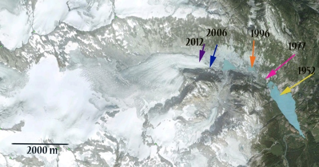
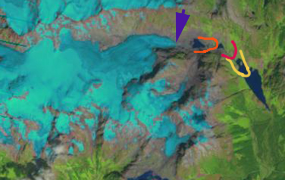
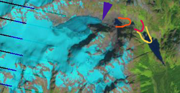
Stave Glacier is a six kilometer long valley glacier in Garibaldi Provinical Park, British Columbia. Koch et al (2009) in their detailed survey of glaciers in the park chronicled the glacier’s retreat from 1952 to 1996. Here we update the changes in Stave Glacier to 2012. Koch et al (2009) completed a map, first image that indicates the retreat rate of the glacier as 26 meters/year from 1900-1952, 33 meters/year 1952-1977 and 53 meters/year from 1977 to 1996. Examined below is Google Earth imagery from 2006, aerial photography from 2009 and Landsat imagery from 2009 and 2012. The Google Earth image indicates the terminus position using arrows in 1952 (yellow arrow), 1977 (pink arrow), 1996 (orange arrow), 2006 (blue arrow) and 2012 (purple arrow). In the Landsat images the same color scheme is used, for terminus front lines also. The retreat from 1996-2012 is 1600 meters, 100 meters/year. This glacier is still not approaching equilibrium as the accelerating retreat indicates. 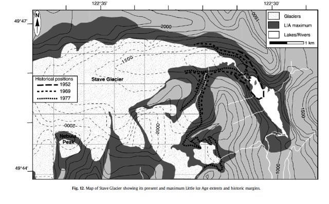
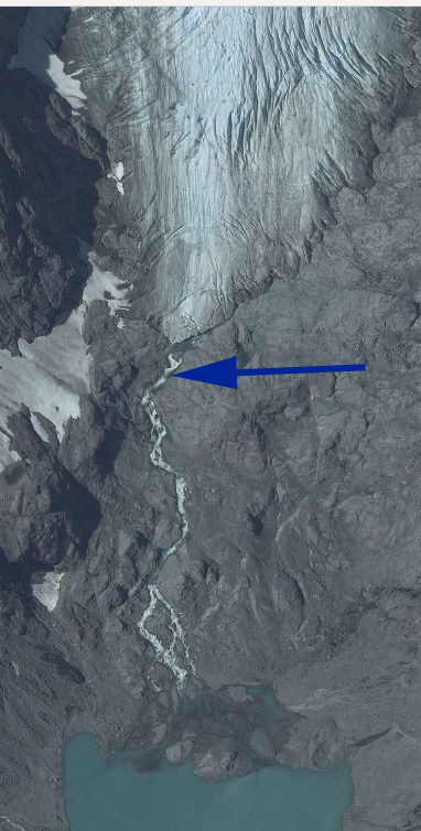
 A close up of the terminus in 2006 (top) and 2009 (bottom) indicates the lowest couple hundred meters is thin and uncrevassed indicating retreat will continue. The glacier terminus is at 1275 meters today. There is an active icefall above the terminus at 1500 meters, the snowline has been at 1900 meters. Unlike the nearby Helm Glacier, Stave Glacier has a persistent accumulation zone and can survive current climate. Its behavior is similar to that of Warren Glacier.
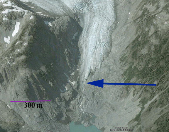
Tag: British Columbia glacier retreat
Jacobsen Glacier, BC Retreat
Jacobsen Glacier is part of the Monarch Icefield of the Coastal Range of British Columbia. VanLooy and Forster (2008) noted that the glacier retreated at a rate of 30 meters/year from 1974 to 1992 and 47 meters/year from 1992-2000. In this post we examine Landsat satellite imagery from 1992, 1994, 2010 and 2012 to illustrate the changes over the last two decades. There are three readily observable changes. The first, indicated by purple arrows, is the lateral recession 2.5 km upglacier of the current terminus. At this point the glacier was in contract with a proglacial lake. The lake shoreline has not changed from the 1992-1994 images, but the glacier margin is now 300 meters distant from the lake margin. The second change, indicated by yellow arrows, is of what was previously a secondary terminus that terminated in a small proglacial lake in 1992-1994. This small lake has turned into an embayment of the larger unnamed lake that the Jacobsen Glacier ends in. The secondary terminus has retreated 900 meters since 1992. The last change is the actual terminus retreat of Jacobsen glacier with the 1992 terminus indicated by the pink arrows and the 2012 terminus by the blue arrow on the northern margin. The retreat and lake expansion has been 1100 mters from 1992-2012, a rate of 55 meters/year, only a slight change from the 1990-2000 reported rate. 


 The changes indicate a consistent mass balance loss that is typical of glaciers in the Coast Range from Lemon Creek Glacier to Bridge Glacier and Helm Glacier. The ongoing mass balance losses are resulting in substantial glacier area and volume losses ( Pelto, 2007; Scheifer et al, 2008).
Washmawapta Glacier Retreat, British Columbia
The West Washmawapta Glacier and Washmawapta Icefield are located in the Vermillon Range in British Columbia . They are in a basin between Limestone Peak and Helmet Peak. The West Washmawapta is a cirque glacier and has been the focus of detailed studies of its dynamics and runoff in recent years. The study of its dynamics (Sanders et al, 2010) measured velocities of 3-10 meters/year, pretty typical for a cirque glacier of this size, and had a maximum depth of 185 m, a bit deeper than usual. The runoff study (McGregor, 2007) and Dow et al (2011)examined streamflow below the glacier and found that peak flow was at 2100 hours, several hours after peak melting. They conclude that this indicates a well developed subglacial drainage system. Sanders et al (2010) noted that West Washmawapta Glacier lost 30% of its area from 1949-2007. A comparison of Google Earth imagery from 2002 (top) and 2007 (middle) and Landsat imagery from 2009(bottom) identifies changes in the two glacier in the last decade. For the West Washmawapta Glacier in 2002 the glacier ended in contact with two proglacial lakes (Point A-C) and a lake that is just forming at Point B. The retreat is from 30-50 meters in this five year span. In the 2009 Landsat the Lake at Point C is well separated from the glacier.

 For Washmawapta Icefield, does not really deserve the icefield title, has lost a lower former glacier section that was in contact with Elizajan Lake, green arrow. The purple areas point to two prominent bedrock features that indicate retreat of 30 meters over the five year time span. The problem for both glacier is the insufficient size of the accumulation area. In 2009 the image is from August 20th, a month left in the melt season and only 40% of the glaciers are snowcovered. An alpine glacier like these needs at least 55% snowcover to be in equilibrium. The 2007 imagery in from July and the accumulation area is at 65%, by September of 2007 the extent was down to 35%.
 Now if you are still not sated, the video on the West Washmawapta Glacier project illustrates the amount of hard work and good humor that is essential to complete such a field project is quite a treat.
Apex Glacier Retreat British Columbia
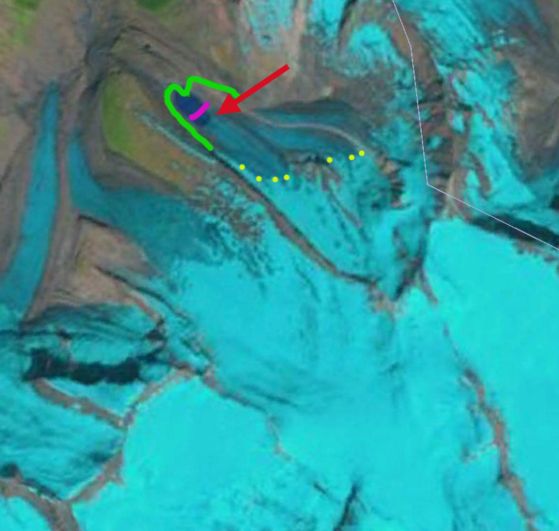
The Apex Glacier is part of the Clemenceau Icefield Group in the Rocky Mountains of British Columbia. The Apex Glacier drains into 430 square kilometer Kinbasket Lake impounded by the 1.75 MW Mica Dam.  In a recent paper Jiskoot et al (2009) examined the behavior of glacier in this and the neigboring Chaba Icefield. They found that from the mid 1980’s to 2001 the Clemenceau Icefield glaciers had lost 42 square kilometers, or 14% of their area. During this same period terminus retreat averaged 21 meters per year on the glaciers. In this post we are looking just at Apex Glacier contrasting the mapped extent, 2001 extent and 2010 extent in a Landsat image. A new glacier lake began to form after the 1980’s mapped extent. In the images below the 1980’s terminus is marked with a green line, the 2001 extent in magenta. By 2001 in the Google Earth image the lake is 0.5 km long, in 2010 the lake is 0.8 km long.

Glacier Map
2001 Google Earth Image
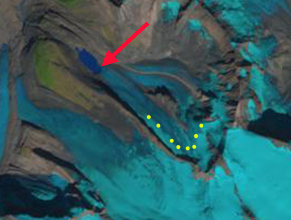
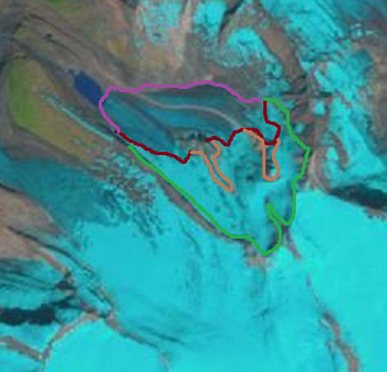
2010 Landsat image Apex Glacier’s retreat of 300 m in nine years exceeds 30 meters per year, red arrow 2010 terminus. Hester Jiskoot’s (University of Lethbridge, Alberta) found a retreat rate of 52 meters per year from 1986-2001. The reduced rate of retreat may result from the lake depth being reduced, that the lake is getting a bit narrower hints at this as well. One other interesting aspect is that this glacier is fed by a northern and a southern accumulation zone. The snowline is 2400 to 2500 meters in the 2010 August Landsat image. The remaining accumulation zone is quite small for the northern accumulation zone with another month of melting to go. The ablation zone is between the purple margin and burgundy snowline. The accumulation zone is between the snowline and the green upper limit of the glacier, with the bare rock areas noted with the tan line. In 2013 the glacier has continued to retreat, though the change of approximately 100 m since 2010. In 2013 the glacier lost all but 10% of its snowcover with the snowline at 2700 m, yellow dots. This represents a large negative mass balance that will reinforce retreat.
2010 Landsat image
2013 Landsat image
2010 Landsat image
The result for Kinbasket Lake of the loss of the collective large area is a reduction in summer glacier melt and summer glacier runoff. The annual runoff which will be dominated by annual precipitation would not change just because of the glacier loss as noted in cases like the Skykomish Basin (Pelto, 2011) and Bridge River (Stahl et al 2008).
Bridge Glacier Retreat Acceleration, BC, Canada
Bridge Glacier is an 17 km long outlet glacier of the Lilloet Icefield in British Columbia. The glacier ends in a rapidly expanding glacial lake with 1100 meters of retreat from 2005-2010. This 200+ m per year retreat is a substantial acceleration over the observed retreat rate of 30 m per year from 1981-2005 by Allen and Smith (2007). They examined the dendrolchronology of Holocene advances of the glacier and found up to 2005 a 3.3 kilometer advance from the primary terminal moraine band, with the most extensive advances being early in the Little Ice Age. The glacier currently ends at 1400 m and in 2010 had a late summer snowline of 2000 m.  . The glacier terminus in 1970 is shown in map form, and is indicated by a brown line. The 2003 terminus position from a Landsat image, second image, is next with a red line marking the terminus. The normal Google Earth image, third image, is from 2005 and has a green line. An image from Geoeye from August 2010, last image, terminus purple line indicates the rapid acceleration of retreat. Retreat from 1970-2003 was 48 m per year. The retreat from 2003 to 2010 is 1400 meters, 200 m per year.


 This continued retreat and area loss will lead to glacier runoff decline in summer. This is crucial to the large Bridge River Hydro complex. This complex managed by BC Hydro can produce 490 MW of power. Stahl et al (2008) note in their modeling study of the glacier that ,”The model results revealed that Bridge Glacier is significantly out of equilibrium with the current climate, and even when a continuation of current climate is assumed, the glacier decreases in area by 20% over the next 50 to100 years. This retreat is accompanied by a similar decreasein summer streamflow.” This parallels our findings on the Skykomish River in the North Cascades, Washington Pelto (2008) and Pelto (2011).
Warren Glacier Retreat, British Columbia, Canada
Warren Glacier in Garibaldi Provincial Park, British Columbia, Canada terminus retreat has been observed for over a century.  A period of extensive retreat from 1890-1964 was followed by a period of minor advance from 1973-1977, and then rapid retreat from 1977-2009. Johannes Koch has documented this retreat in the map below and with the historic images as well, the work has been published with less colorful graphics (Koch et al., 2009).
 . When I first saw the glacier in 1986 it had just retreated from the edge of the lake. By 2003 as seen in the somewhat blurry satellite image below, the glacier was 310 meters from the lake edge. In the 2009 Google Earth image the glacier is 500 meters from the lake edge. The rate of retreat over the 25 year period is 20 meters per year. The rate of retreat has again increased from 2003-2009, being 32 meters/year.
 The upper section of the glacier has unlike nearby Helm Glacier maintained some snow covered areas even in poor snow summers such as 2005 and 2009. This suggests the glacier can survive current climate with further retreat. The average thinning of Warren Glacier is similar to that of Helm, Sphinx and Sentinel Glacier at nearly 50 meters since 1928, note Figure 14 (Koch et al. 2009). This thinning due to ongoing negative mass balance has led to a 50% reduction in area since 1928. The large area loss as a percentage reflects the large relatively flat low lying basin now occupied by the lake.
Castle Creek Glacier, BC annual retreat recorded
Castle Creek Glacier is in the Cariboo Mts. of British Columbia. The glacier descends north-northeast for 6.3 km from 2825 meters to the terminus at 1,810 meters. During the last 50 years of retreat has left a series of annual terminal recessional moraines that indicate how much the glacier has retreated each year. The glacier has a remarkably uniform and relatively low slope for an alpine glacier. This is one feature that helps ensure that the retreat rate changes little from year to year as the glacier flow dynamics are consistent. There is no prominent icefall, there is no low slope terminus tongue that can stagnate. The extent of the glacier during the Little Ice Age is quite evident as the gray vegetation free zone. 
 Castle Creek Glacier has receded every years since 1959 at total of 720 meters up to 2008, about 14 meters per year. The Universtiy of Northern Brictish Columbia as part of the Western Canadian Cryosphere Network has undertaken a detailed investigation of this glacier. Matt Beedle at UNBC has been the field leader for the project, and has had the chance to map and identify the annual recessional moraines. The three pictures below are from Matt Beedle. The first is a series of aerial photographs that have been cropped to show the same area. Note that in 1946 the glacier filled the view, by 2005 it barely makes the image. The period from 1971 to 1991 has the most notable recessional moraine ridges. Beyond the 1967 margin there are at least 10 moraine ridges
The recessional terminal moraines are not unusual features to be formed by a retreating glacier, however they are unusual to be formed each year and to be so well preserved. The recessional moraines are deposited on a till plain exposed by the glacier retreat. Often such moraines are ice cored and tend to disappear as the ice core melt outs, not the case here. The moraines form during the winter when the glacier continues to move and the terminus is not melting. In summer after the terminus area is exposed the terminus melts back. The Key as pointed out by Matt Beedle is summer temperature. Such moraines will not form on a glacier with a stagnant glacier tongue. Such moraines also do not form on glaciers that have a terminus area that is an avalanche runout zone that can bury the terminus some years.

The glacier fits the pattern of glaciers throughout the southern interior ranges of BritishColumbia and Alberta which Blch et al (2010) noted lost 11% and 25% of their area over the period 1985–2005 respectively.
Spearhead Glacier and Decker Glacier retreat, Whistler, British Columbia
Spearhead Glacier is just east of the Whistler-Blackcomb Ski area in sw British Columbia and can be reached easily from the top Blackcomb lift. Adjacent to Spearhead is Decker Glacier . Both glaciers flow northwest and have retreated extensively. Recently both have developed new alpine lakes at their termini that illustrate the recent increase in retreat that could continue thanks to these new lakes. Spearhead Glacier has retreated between 500 and 600 meters since 1928. The glacier lost 62 m in mean thickness since 1928 Koch and others (2009) found. A map of the region indicates the extent of the glaciers in the range from the Little Ie Age and today Osborn and others (2007). The first image is from 2003, the low sloped glacier has few crevasses and end in a gently sloping terminus at the edge of the bedrock basin. Notice in the fall 2008, second image, that a new lake has formed at the terminus Spearhead Glacier.
 This lake is expanded further in 2009 as seen in this view below across the lake back at the glacier.
  This looks much like the expanding lake view and stagnant terminus area of Colonial Glacier in the North Cascades. The glacier is largely confined to a single basin, that suggests the potential for considerable lake expansion as the glacier retreats. There is a step in the glacier in the image above, that indicates the likely maximum extent, notice the bedrock step on the right side of the glacier. Decker Glacier retreat is even more substantial as a percentage of glacier area. illustrated in a comparative image from Osborn and others (2007)
 The glacier has also developed a new lake, leading to the breakup of a portion of the end of the glacier, notice the rifted ice pieces in the image below from October 2008. That was not present in the lower image from 2003. This area of broken ice at the end of the glacier and near the image bottom, represents nearly a third of the total glacier area. It is not as apparent as it is in summer conditions when the lake is not frozen over.

Helm Glacier Melting Away-2014 Video Update
It is clear that the business model for glaciers in our current climate is not working. The Helm Glacier in the Coast Mountains of southwest British Columbia is an example of this. Helm Glacier has been the focus of annual mass balance surveys since 1967. During the 1984-2013 period its mass balance losses have been the greatest of any of the 16 glaciers monitored in North America. The mass balance loss has been about 32 m of water equivalent, about 35 m of ice thickness lost. This is less than losses on other nearby glaciers like Spearhead Glacier but more than others such as Warren Glacier. The regional volume loss has impacted even the large glaciers Bridge Glacier and small glaciers. The loss is more than 30% of the Helm lost in just 25 years, and the trend mirrors that of all glaciers in the Pacific Northwest. Helm Glacier also fits into the pattern of glacier retreat across Canada, Canadian Glacier Retreat index.  The glacier had an area of 4.3 square kilometers in 1928. Today the area has declined by 78% to 0.92 square kilometers. In 1928 the glacier is not too distant from its Little Ice Age moraines. The trimlines of recently deglaciated terrain are clear. The glacier has two termini, one draining north and the other west. Today in the picture from Johannes Koch, there is a vast expanse of newly deglaciated terrain that as yet lacks significant vegetation. The western terminus is gone.
Remainder of post and updates moved to
Helm Glacier
