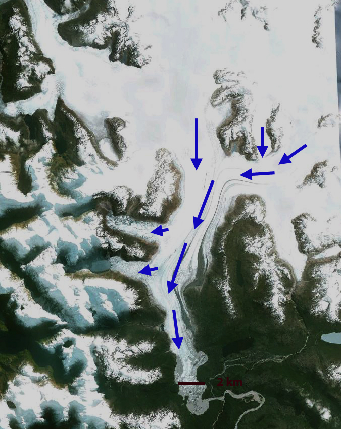
Verde Glacier is adjacent to Reichert Glacier and drains the north side of the Northern Patagonia Icefield. It is a small glacier compare to many outlet glaciers of the icefield that have been examined in previous posts, Reichert Glacier, Steffen Glacier, Nef Glacier, and Colonia Glacier. Here we examine Landsat imagery during the 1998-2014 period to identify the response of the glacier. The glacier flows from a pair of peaks at 1800 m to terminate at the edge of a proglacial lake. There is a significant icefall at 800-1250 m and a significant avalanche fan at the base of this icefall that is spills from a disconnected portion of the glacier west of the terminus and just northwest of the icefall. Davies and Glasser (2012) Figure 2d indicates the glacier nearly filling the entire lake in 1975. In Figure 8a they indicate the fastest retreat for the glacier being from 1998-2014. Rivera et al (2007) indicate the ELA for the glacier at the top of the icefall 1250 m. 
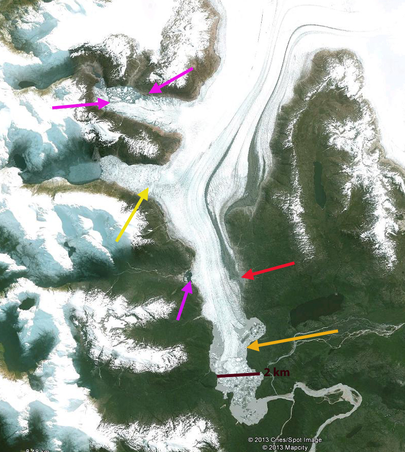
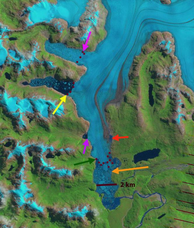
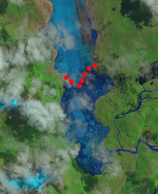
The yellow arrow in each image is the 2014 terminus and the red arrow the 1998 terminus. In 1998 the glacier terminates at the red arrow just beyond the northeast bend in the lake. The lake is 1.6 km long. By 2001 the glacier has retreated 300 m and is at this bend. Notice that the lowest lone kilometer of the glacier is quite debris covered. By 2014 the glacier has retreated to the yellow arrow, this is a further 600 m retreat since 2011. The lake is 2.5 km long measured along its center line. The 900 meter retreat in 16 years is substantial for a glacier that is only 5 km long. A cloe up view of the terminus in a Goggle Earth image indicates that the lowest 300 m is debris coverered ice, notice the wetness of some of the debris, pink arrow. This looks more like ice cored moraine than active glacier ice covered by debris. If this is the case the active terminus is 300 m from the shore of the lake, at the yellow terminus where calving begins. It is certain the lake will expand further as the buried ice melts, but it is nearing its southwestern limit. The steep slope of the icefall and the rock slope to the right of the icefall is evident. This will lead to continued avalanching onto the terminus area, that will make that lowest region above the yellow arrow more difficult to melt out. One observation that is striking is the number of narrow alpine lakes that have formed and expanded as the Northern Patagonia Icefield outlet glaciers have receded. 
1998 Landsat image
Tag: chile glacier retreat
Glaciar Steffen, Chile Retreat and Lake Expansion
Glaciar Steffen is the south flowing glacier from the 4000 square kilometer Northern Patagonia Icefield (NPI). Several key research papers have reported on the spectacular retreat of this glacier in recent years. Here we report those result and examine Landsat and Google Earth imagery to fully illustrate the changes. A JAXA EORC, 2011 report compared parts of the Glaciar Steffen terminus change from 1987 to 2010. They noted a retreat of approximately 2.1 km of the main stem and 870 m of a western terminus. They noted a remarkable collapse of the terminus tongue. Davies and Glasser (2012) in examining changes in Patagonian glaciers that the rate of area loss of the NPI increased dramatically after 2001, and has been 9.4 square kilometers/year. The loss of 94 square kilometers is 2.25% of the entire NPI. Rivera et al (2007) reported that Glaciar Steffen lost 12 square kilometers and had an average thinning of 1.5 m in the ablation zone from 1979-2001.

In this examination we use an EROC provided image from 1987, Landsat from 1999, Google Earth 2003, Landsat 2004, Landsat 2011, Landsat 2012 and Landsat 2014. The light orange arrow is in the same location a reference point for the main terminus in each image. The terminus is indicate by burgundy dots. There are three lakes on the west margin of the glacier that have been fed by separate glacier tongues. From south to north they are indicated by a purple, yellow and pink arrow. A new lake has emerged on the east side of the glacier at the orange-red arrow which is at the same location in each image. In 1987 the lake at the terminus of the glacier is 1.3 km from north to south. The NW most terminus is 4 km from the main trunk of Steffen. The middle west terminus, yellow arrow extends 1.7 km west from the main trunk. There is no lake evident at the red arrow. In 1999 the northwest terminus has retreated little but is showing signs of breakup. The middle west terminus, yellow arrow, has retreated to within a half kilometer of the main trunk by 1999. The main terminus has retreated little sinc 1987 on the west side but has retreated 700 meters on the east side. In 2003 the northwest terminus has begun a retreat exposing a new section of lake. The middle terminus cannot be discerned. The main terminus is now an isolated tongue in the midst of the terminus lake, with open water along the east and west margins. In 2004 the northwest terminus has changed little from 2003. The middle terminus is evident from a shadow that can only come from the calving front cliff, it appears advanced somewhat from 1999. By 2011 the main terminus tongue from 2003 and 2004 is gone, the terminus has retreated north of the orange arrow. A new lake is evident on the east side at the red arrow. The middle west terminus has retreated back to the main glacier. In 2012 the main terminus has retreated 3.4 km from 1987, there are small lakes on either side of the glacier above the terminus indicating that the lower 2 km of the glacier is still likely to be lost soon, back to the red and pink arrows. Modest retreat has occurred by 2014 but is difficult to quantify in the cloudy image. The northwest and middle west terminus are both nearly back to the main glacier having retreated 3.8 km and 1.3 km respectively since 1987. This retreat includes that of , Gualas GlacierReichert Glacier, Nef Glacier, and Colonia Glacier.

1987 EROC image
Alemania Glacier Retreat, Lago Martinic expansion-contraction, Chile
The Cordillera Darwin in Tierra Del Fuego Chile is a remote area. GLIMS (Glacier Land Ice Monitoring from Space) which has an inventory of glaciers showing at least size and boundaries, has nothing for this region in 2012. The USGS in their publication on South American glaciers just notes the lack of satellite imagery for assessing these remote glaciers. Chile is currently undertaking an inventory of these glaciers. The Alemania Glacier (Roncagli) is the focus of this post, the glacier can be seen from the Beagle Channel. The focus is not main terminus, but the terminus that ends in Lago Martinic (LM). In Google Earth imagery imagery this lake is trapped by the Alemania Glacier.
There are two smaller glacier draining into the west end of the lake and Alemania’s secondary terminus ends in the lake. The red arrow points to the terminus, the green arrow to a nunatak near the Lago Martinic terminus and the yellow arrow to a developing nunatak upglacier, AT indicates the main terminus of the Alemania Glacier. The next three images are all from Landsat and indicate some spectacular changes from 2000 top image, 2008 middle image and 2011 bottom image. From 2000 to 2008 the Lago Martinic terminus of the glacier retreat 1300 meters, reaching the nunatak by 2008, this represents a significant expansion of the lake. In 2011 the terminus has retreated little but the lake has drained to an extent exposing the pink areas of the former lake bottom. In the future this maybe a lake that periodically fills in the Austral Spring and drains later in the Austral summer. The main terminus of the Alemania Glacier also exhibits a notably developing lake at the terminus compared to 2000, more on this below. The upglacier nunatak, yellow arrow, has also become more exposed indicating glacier thinning. 

A closeup of the main terminus of the Alemania indicates a 500 meter retreat of the east side of the glacier from the 2000 GE imagery to the 2011 Landsat imagery. The lake at the terminus has become significant, this should speed retreat in the near future. Though further south than the large Patagonia Icefields the glacier changes mirror those of the main icefields, Colonia, Tyndall, Gualas that are being intensively investigated by the Chilean Laboratorio de Glaciologia

Colonia Glacier Retreat and Glacier Lake Outburst Floods
Colonia Glacier drains east from the Northern Patagonia Icefield feeding the Baker River, Chile. The recent substantial retreat of Colonia Glacier like Glacier Nef just to its north is posing new hazards. The glacier is unusual in the number of lakes that are adjacent to or feed into the adjacent glacier damed or proglacial lakes. In the image below Lake A=Arco Lake, Lake B=East Terminal Lake, Lake C=Cachet 1 , Lake D= West terminal Lake, Lake E=Colonia Lake and Lake F=Cachet 2.
The glaciers recent retreat and glacier lake outburst floods have been closely monitored by the Laboratorio de Glaciología in Valdivia, Chile.Aniya and others (1999)observed that Colonia Glacier began a rapid retreat after 1985
Superimposition of a RADARSAT image from 1997 and a Landsat 1987 image indicated a retreat of
400 m, from 1997-2005 the retreat has further accelerated, with a general frontal retreat of 2.5 km.
Rivera and others (2007) observed that the Colonia Glacier had lost 9.1 square kilometers of area from 1979-2001, which is 3% of the total glacier area. The Laboratorio de Glaciologia’s
In the spring of 2008 Baker River suddenly tripled in size, in less than 48 hours, roads, bridges, and farms were severely damaged. Lake Cachet 2 had vanished the 5 square kilometer glacial lake had emptied 200 million cubic meters of water in just a matter of hours. This lake drained beneath the glacier after sufficient water had filled the lake to buoy part of the glacier and subglacial conduits had begun to develop. Since Cachet 2 emptied in April 2008, the lake has emptied five more times October,
December 2008, March and September 2009 and March 2010, with peak flows released of
3000 cubic meters per second. Below are images of Cachet 2 half- full in Google Earth Imagery from Sept 2008 (note trimline above lake), and full after the flood on 5/28/2008 and empty on 4/8/2008, and lastly the image of the Colonia River’s wide fresh braided stream channel flowing into the Baker River. The newly deposited material from the flood is what makes the wide braided valley such a fresh sediment brown color. 

The two lakes at the terminus of the glacier did not exist in 1979, the western most terminus lake (B) drained into the easternmost terminus lake (D) via a sub-glacial tunnel after formation in the late 1980’s until 2005 when a channel was cut right through the glacier terminus. This is evident in the image below, there is still glacier ice on both sides of this drainage channel. 
The development and demise of glacier dammed lakes and the resultant problem of glacier lake outburst floods is not rare today, Imja Glacier, and Tulsequah Glacier are other examples. In the case of Baker River the outburst floods are a threat to the planned hydropower developments as documented by Dusaillant and others (2009). The Colonia Glacier retreat mirrors that of Glacier Nef the next major glacier to the north. Hidroaysen Project is proposing 5 dams on the Baker and Pascua River generating 2750 MW of power. Glacier Nef retreated 3400 m from 1945-2000, 2400 m retreat of the retreat occurred in the 1994 collapse of the terminus tongue into the proglacial lake, which is now 3.5 km long. This retreat includes that of , Gualas GlacierReichert Glacier, Steffen Glacier, and Nef Glacier.
Glacier Nef Retreat, Rio Baker, Chile
Glacier retreat and thinning is particularly strong in the Patagonian icefields of South America. The two largest temperate ice bodies of the Southern Hemisphere are the Northern Patagonia Icefield (CHN image below) 4,000 km2 and the Southern Patagonia Icefield (CHS), 13,000 km2.
It has been estimated that the wastage of the two icefields from 1995–2000 has contributed to sea level rise by 0.105 ± 0.011 mm year,which is double the ice loss calculated for 1975-2000 (Rignot et al. 2003).Nearly 90% of the glaciers studied are affected. Of the 72 glaciers surveyed in the region 63 have retreated significantly, only eight have remained stable and one advanced. O’Higgins Glacier, which feeds the Pascua River has retreated 11.6 km, IRD, 2010. Baker River (Rio Baker) is located to the east of the Northern Patagonia Icefield and is fed mainly by glacier melt water originating from the eastern outlet glaciers of the iecefield Leones, Soler, Nef, Colonia. Rio Baker is the most important Chilean river in terms of runoff, with an annual mean discharge of about 1000 m3/s . Glacier Nef is one of the main glaciers feeding Rio Baker. Rio Baker is a critical hydropower resource for Chile. Hidroaysen Project is proposing 5 dams on the Baker and Pascua River generating 2750 MW of power. Glacier Nef retreated 3400 m from 1945-2000, 2400 m retreat of the retreat occurred in the 1994 collapse of the terminus tongue into the proglacial lake, which is now 3.5 km long as seen in the image from Pierre Chevallier IRD.
The glacier has an area of 164 km2 the proglacial lake began to from after 1945, but was less than 1 km long until after 1994. The glacier had primarily been thinning in height and width near the terminus from 1945-1994
(Aniya, 1986 ) and Winchester, et al. (2010). Below is a map of the hydropower project, from Hidroaysen Project .
Today Glacier Nef has not reached the head of this proglacial lake and will continue to retreat. The west side of the terminus is debris covered and has a fringing proglacial lake. The lack of elevation change and the isolated proglacial lake here suggests the lake will expand laterally as well as length wise. The retreat follows the pattern of enhanced calving in a proglacial lake for NPI glaciers such as , Gualas GlacierReichert Glacier, Steffen Glacier, and Colonia Glacier. The retreat via calving due to a thinning terminus tongue is similar to the case on Gilkey Glacier, Alaska, Tasman Glacier, New Zealand and Triftglestcher, Austria. The visible trimline indicates the thinning. The lack of vegetation indicates the recent nature of the retreat from this lateral trimline. 
The glaciers feeding Rio Baker remain quite large and will remain a large meltwater source for the forseeable future. The majority of Glacier Nef is above the recent equilibrium line altitude of 1200 m. The section of the Rio Baker below is where one of the dams will go.


