Hochstetter Ice Cap Loses All Snowcover in 2020, Franz Josef Land

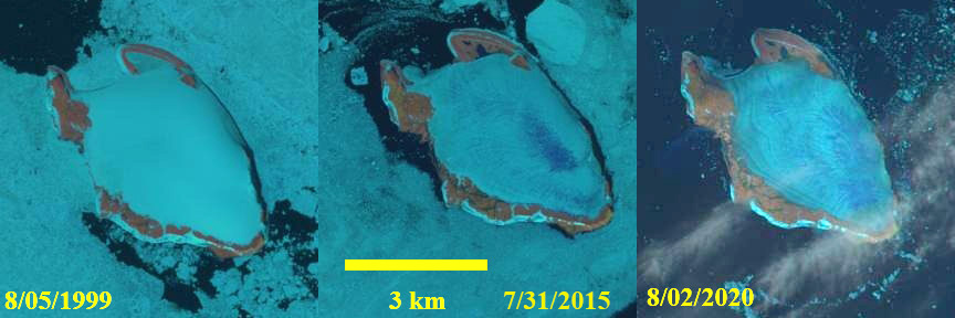
Landsat images from 1999, 2015 and 2020 of Hochstetter ice Cap.  Snowcover=100% in 1999, 80% in 2015 and 0% in 2020.

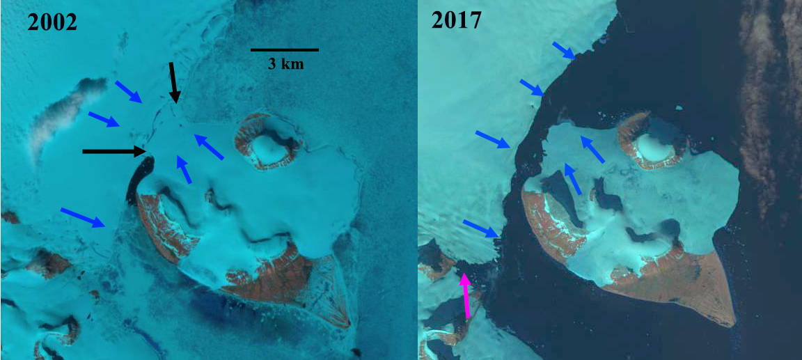
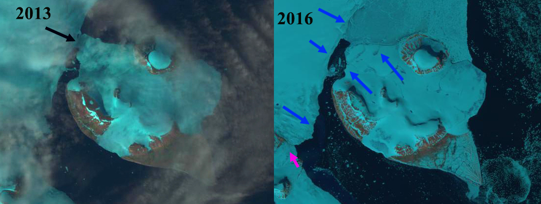
Hochstetter Ice Cap covers most of Hocstetter Island (Ostrov Khokhshtettera) in the the southern part of the Franz Josef Land archipelago.  Situated ~1000 km from the North Pole this area is known for its white ice caps and cold summer temperature averaging 2 C.  The lack of sea ice in the region is exposing the marine margins of the ice caps in Franz Josef Land to enhanced melting.  This has and will lead to more coastal changes and island separations (Ziaja and Ostafin, 2019), such as occurred on Hall and Littow Island. Here we examine Landsat imagery from 1999-2020 to reveal changing snowcover. The summer of 2020 featured record low sea ice in the Barents Sea by mid July (NSIDC, 2020),  due to the Siberian heat wave this past spring which led to early ice retreat along the Russian coast.

In early August 1999 the island is mostly surrounded by sea ice and the ice cap is fully snowcovered. In July 2000 and 2002 the situation is similar with insignificant exposed ice. At the end of July 2015 the island is mostly surrounded by sea ice, while the island is largely snowcovered there are meltwater saturated blue areas on the ice cap.  On August 2, 2020 there is no snowcover on the ice cap and very limited sea ice around the island.  Three weeks later on August 22, 2020 the ice cap remains bare of snowcover and is hardly the bright white that the area is known for.  This period of extensive ice exposure leads to significant ablation of the exposed darker and older glacier ice leading to a large mass balance loss and glacier thinning.

Hochstetter Ice Cap in  early August 2020 has lost all of its snowcover and has little sea ice in the vicinity. The blue coloration to the ice cap indicates meltwater is present.

Landsat images from 2002 and 2020 of Hochstetter ice Cap.  Snowcover=100% in 2000 and 0% in 2020.

Franz Josef Islands Separate due to Glacier Retreat

Hall Island (left) and Littrow Island (right) in 2002 and 2017 Landsat images.  The islands are connected by glacier in 2002 between the black arrows.  The blue arrows indicate glacier flow.  In 2017 the glacier connection has failed and Nordenskjold Strait has formed. 

Hall and Littrow Island are two islands in the southern part of Franz Josef Land, Russia that have until 2016 been connected by glacier. Sharov et al (2014) generated a map with the MAIRES Project illustrating the glacier connection was failing, see below. Sharov and Nikolskiy (2017) further report on the failure of this glacier connection.  Here we utilize Landsat imagery from 2000-2017 to illustrate the change.

In 2000 the island are surrounded by considerable sea ice and there is a 3 km wide glacier connection, black arrows.  In 2002 the island are again surrounded by considerable sea ice that is distinguishable from the glacier ice.  The glacier connection between the island remains 3 km wide, black arrows, with blue arrows showing the direction of ice movement.  By 2013 the connection has narrowed to 0.7 km and there is no sea ice.  In 2016 the glacier connection is gone between hall and Littrow Island and Nordenskjold Strait has formed.  There is sea ice on the northern shore of Littrow Island reaching to Hall Island. To the southwest the pink arrow indicates where the Sonklar Glacier connects with an unnamed glacier in 2016.  In 2017 there again is no sea ice and the open water between Littrow Island and Hall Island is more apparent. The inlet averages 800 m in width.  The connection between Sonklar Glacier and the neighboring glacier, at the pink arrow, has failed. The lack of sea ice in the region is exposing the marine margins of the ice caps in Franz Josef Land to enhanced melting.  This has and will lead to more coastal changes and island separations.

Hall Island and Littrow Island in 2013 and 2016 Landsat images.  The black arrow indicates a narrow connection in 2013.  In 2016 the glacier connection has failed and Nordenskjold Strait has formed.

Map from MAIRES (Monitoring Arctic Land and Sea Ice from Russian and European satellites) showing the changing connection between islands. 

2000 Landsat image indicating connection between islands at black arrows.