Honeycomb Glacier Retreat, Washington New Lake Lost Nunatak

Honeycomb Glacier in Google Earth imagery from 1998 and 2016.  The dark orange line is the 1998 margin, we mapped the margin in the field in 1995 and in 2002.  The light orange line is the 2007 margin and the yellow line the 2016 margin. Note crevassing diminished as well. 

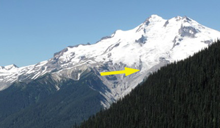
Honeycomb Glacier is one of the longest and largest glaciers in the North Cascades.   In 1979 it was 3.9 km long and had an area of 3.5 km2. By 2016 the area had declined to 2,6 km2 and it has retreated 2.6 kilometers since its Little Ice Age Maximum. The glacier was an imposing site to C.E. Rusk who recounted his early 20th century exploration (1924). Like all 47 glaciers observed by the North Cascade Glacier Climate Project it has retreated significantly since 1979. The glacier feeds the headwaters of the Suiattle River, which is also an important salmon stream, for chinook, coho, sockeye and pink salmon (WDFW,2018).

A 1960 photograph taken by Austin Post, USGS shows the glacier ending with no lake at its terminus. The terminus is gentle and has no crevasses, indicating it is relatively stagnant and poised to melt away. The glacier has retreated 1.3 km from its Little Ice Age moraines at this point. In 1967 another Austin Post image indicates a new small lake forming at the terminus.
honeycomb

In 1995 we mapped  the margin of the glacier ending in this lake, where the glacier ended in 1967 and took a photograph back to the glacier. As seen below retreat to this point was 400 m.

honeycomb 1995

A pair of images from Bill Arundell in 1973 and Lowell Skoog in 2006 indicate the scale of the retreat, these images do not show the actual terminus but do show the main nunatak-rock island and how much it has become exposed in the 33 years. This nunatak was hardly evident in 1960, and in a 1940 image of the glacier literally did not yet exist.honeycomb-glacier-1977-2006

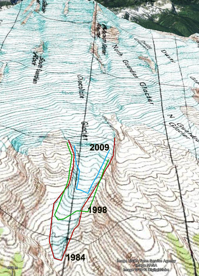
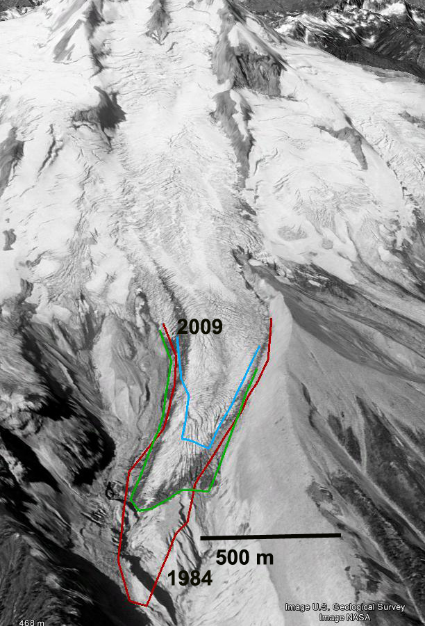
The terminus had retreated 400 m from the 1967 position to 1995. In 1987 a new lake began to form at the terminus of the glacier at 1680 m. The glacier is shown ending in this lake in 2002 from both the far end of the lake and the nunatak above the lake, the glacier had retreated 210 m since 1995. In 2006 the glacier retreated from the end of this lake. This is a shallow lake that may eventually be filled in by glacier sediments. The terminus is flat and stagnant ending at 1680 m in the lake. Thus, the rapid retreat will continue, the glacier is still not close to acheiving a post LIA equilibrium. Glacier retreat from 1940-1967 averaged 9 m/year. Retreat was minor between 1967 and 1979. The retreat rate from 1979-1998 was greater at 16 m/year, with a total retreat of 300 m. The retreat than increased from 1998-2016 with the west branch retreating 800 m and the east branch 500 m. The nunatak in the middle of the glacier, which was beneath the ice in 1940 was 90 m above the ice in 2002 when we mapped it.  By 2009 it was no longer a nunatak as the glacier did not merge downstream of the this bedrock knob.

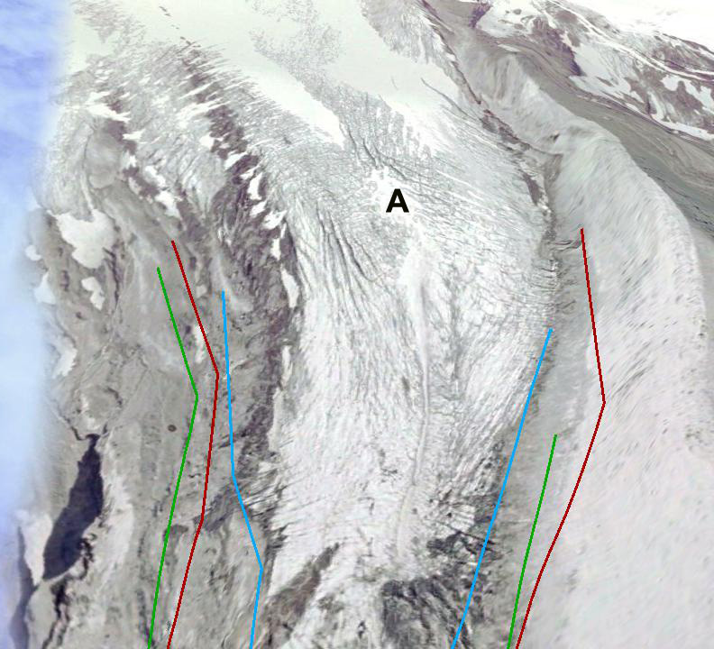
The retreat of this section of the glacier results in a reduced melt area of ~1 km2 in the last 40 years.  This in turn reduces summer glacier runoff as there is no longer snow/ice melting each day under the warm summer conditions. Flow in the Suiattle River in late summer and early fall has declined as a result. In 2002 during mapping of the glacier images from above and below the nunatak indicate the stagnant nature of the ice below the nunatak.

honeycomb new lakehoneycomb2002a


Chocolate Glacier Retreat, Glacier Peak, Washington

From 1994-1997 we ran a four year project to survey the terminus response of all the glaciers on Glacier Peak, Washington to climate change. This was a century after a climb in the region by C.E. Rusk. Chocolate Glacier is the largest of the east side valley glaciers. The average retreat of Glacier Peak glaciers from the LIA to the 1958 positions was 1640 m. Richard Hubley noted that North Cascade glaciers began to advance in the early 1950s, after 30 years of rapid retreat. The advance was in response to a sharp rise in winter precipitation and a decline in summer temperature beginning in 1944 (Hubley, 1956; Pelto and Hedlund, 2001). All ten glaciers on Glacier Peak advanced. Advances of Glacier Peak glaciers ranged from 15 to 480 m and culminated in 1978 (Pelto and Hedlund, 2001). All Glacier Peak glaciers that advanced during the 1950-1979 period emplaced identifiable maximum advance terminal moraines, that were fresh and easy to recognize in the 1990’s. By 1984, all the Glacier Peak glaciers were again retreating, the North Cascade Glacier Climate Project has monitored this retreat since 1984.chocolate 2005
2005 Glacier Peak east side

glacier tunnel-esker
Cliff Hedlund beneath Vista Glacier during 1994 expedition.

Beginning at 3050 m Chocolate Glacier descends to 1800 m today. When Rusk (1924) first saw this glacier he noted that it presented a dramatic sediment covered front. Immediately above the terminus it was heavily crevassed and quite active, indicating a slow retreat. This glacier which he named Cool Glacier had retreated little from the alpine meadows fringing the south side of the glacier. The terminus had already retreated 400 m up the narrow valley by 1906 from its LIA. A retreat of 1380 m occurred between 1906 and 1946. The retreat was noted to be particularly rapid during the 1920-1940 period by Austin Post. Glacier advance had begun by 1950. An advance from 1946-1955 of more than 200 m occurred (Hubley, 1956). The advance continued up until 1975 totaling 450 m. This was the largest advance of the Glacier Peak glaciers, probably due to the nature of the steep, narrow valley down which the glacier flows from 1960 m to the terminus. The glacier was approximately at this maximum position when mapped in 1984. In the next sequence of images the red line is the mapped 1984 terminus, green is 1998 and blue is 2009. During our visit in 1994 the glacier had retreated 210 m from the moraine it had generated. By 1998 the glacier had retreated 275 m, and was at the based of a steeper slope. By 2009 the glacier had retreated 500 m since 1984, ending at 1925 m, this is still the lowest of the east side glaciers. chocolate 1984
1984 map view

chocolate 1998
1998 Google earth view

Chocolate 2009
2009 Google Earth

Chocolate Glacier remains crevassed and active, but the degree of crevassing has decline from 1998 to 2009 as evidenced by this closeup of the 2000-2200 m region. It is hard to get a good view of this glacier from up close the best vantage is from across the Suiattle River valley, as seen below. chocolate crevasses 1998
1998 Google Earth view

chocolate crevasses 2009
2009 Google earth view

chocolate Glacier 2006
2006 Glacier Peak from the east

chocolate 2007
2007 Glacier Peak from the east

chocolate 2010

Dusty Glacier, Glacier Peak, WA

In the 1990’s the North Cascade Glacier Climate Project undertook a study of all the glaciers around Glacier Peak, one century after they had been first observed by C.E. Rusk. This post focuses on one of those glaciers, Dusty Glacier on the Northeast side of the peak.

In 1940 J.B. Richardson of the Forest Service photographed many North Cascade glaciers surrounding Glacier Peak. From 1946-1958 William Long, of the Forest Service surveyed many glaciers throughout the North Cascades (Long, 1955). From 1950-1955 Richard Hubley, University of Washington, completed the first aerial glacier surveys of North Cascade termini, noting the beginning of an advance on many (Hubley, 1956). The USGS in 1960 began an annual aerial photographic survey of North Cascade glaciers that continued up through 1979. In 1984 the North Cascade Glacier Climate Project began annual terminus observations on 47 glaciers and mass balance measurements on ten of these (Pelto, 1996). The average retreat of Glacier Peak glaciers from the LIA to the 1958 positions was 1640 m. Richard Hubley noted that on Glacier Peak glaciers began to advance in the early 1950s, after 30 years of rapid retreat. The advance was in response to a sharp rise in winter precipitation and a decline in summer temperature beginning in 1944 (Hubley, 1956; Long, 1955 and 1956). Ten of the fifteen glaciers around Glacier Peak advanced, including all of the glaciers directly on the mountains slopes. Advances of Glacier Peak glaciers ranged from 15 to 480 m and culminated in 1978. All 11 Glacier Peak glaciers that advanced during the 1950-1979 period emplaced identifiable maximum advance terminal moraines. By 1984, all the Glacier Peak glaciers were again retreating. This retreat has been monitored by NCGCP. Two of the glaciers including Milk Lake Glacier and North Branch Whitechuck Glacier have disappeared.
The depth of snowpack even in Mid-August near the top of the Dusty Glacier is what drives the rapid movement and crevassing of the glacier. In the first image below the red arrow indicates the annual layer, which was 5.7 m thick in 1997. Thew second image has me standing at the terminus in 1994, which was still active even though it was retreating.

Dusty Glacier has the widest most fearsome crevasses of any glacier in the North Cascades. The glacier descends from 2750 m to 2560 m before plunging over an icefall. The glacier levels out in a basin at 2325 m, before descending a second icefall to its current terminus at 1960 m. Dusty Glacier joined with the North Guardian Glacier during the LIA, separating during the 1930’s. During the LIA the glacier advanced to 1465 m. The retreat of this glacier by 1906 when Rusk observed it had been only 400 m. The glacier ended in a basin that was filled with ice, though much of the ice was stagnant. This basin became known as Recession Basin, for the ensuing rapid retreat up until 1946 when the glacier had retreated out of the basin and ended just north of Recession Rock (R) at 2020 m. By 1955 advance was underway, an advance of 130 m had already occurred (Hubley, 1956). The advance ceased until 1967 when it began again, the glacier reaching another 150 m down into the upper part of Recession Basin at 1865 m. The terminus today is very active with extensive crevassing. In fact it is a true icefall. The glacier retreated 220 meters from its 1970’s advance moraine by 1994 during our first visit, 260 m by 1997-1998 at the time of our second visit and 400 meters by 2006 in the Google Earth imagery. The glacier remains quite crevassed though not nearly as much as in 1955. Below the first image is from 1955 taken by Richard Hubley, the second is in 2004, third in 2006 and last in 2008. In each image Recession Rock is labelled with a purple R, the maximum advance of the 1955-1970’s indicated by a orange arrow and the crevassed top of the lower icefall by a green arrow.

Google Earth images from 1998 and 2006 illustrate the retreat over the last 35 years. This glacier has not lost as much area as others around Glacier Peak, such as Milk Lake Glacier which disappeared, Honeycomb Glacier or Vista Glacier. The area loss has been more modest like on Suiattle and Kennedy Glacier.

Kennedy Glacier Retreat, Glacier Peak Washington

At the turn of the century C.E. Rusk explored the glaciers around Glacier Peak that were retreating from their Little Ice Age maximum in the mid-19th century. The average retreat of Glacier Peak glaciers from the LIA to the 1958 map positions was 1640 m. From 1950-1955 Richard Hubley, University of Washington, completed the first aerial glacier surveys of North Cascade termini, noting the beginning of an advance on Glacier Peak that continued up through 1979. All ten glaciers on the slopes of Glacier Peak advanced ranged from 75 to 500 m and culminated in 1978. All 11 Glacier Peak glaciers that advanced during the 1950-1979 period emplaced identifiable maximum advance terminal moraines. A picture of the glacier from R.Luce during this advance shows a glacier with a strongly convex profile. During the 1993-1997 period the North Cascade Glacier Climate Project (NCGCP) surveyed the glaciers around the peak each summer, one century after C.E. Rusk did (Pelto and Hedlund, 2001). By 1984, all the Glacier Peak glaciers were again retreating. This peak even in summer provided some tough weather, including a 1995 August snow storm. Two other glaciers that were a focus of this study around Glacier Peak were Milk Lake, Vista and Honeycomb Glacier.

This post focuses on Kennedy Glacier which is the main glacier draining the west side of the Peak, left glacier in image below. Kennedy and Scimitar Glacier were joined during the LIA descending the Kennedy Creek valley to an elevation of 1315 m. Retreat from the LIA maximum of 1000 m had occurred by the turn of the century. By 1946 the glacier had retreated an additional 700 m to an elevation of 1960 m. In 1952 the glacier was advancing rapidly, as indicated by the 1955 photograph from Richard Hubley of the glacier from 1955. This advance continued up until 1975, the terminus having extended downslope 320 m to terminate at an altitude of 1785 m. By 1984 the terminus had begun to retreat. In 1994 the terminus had retreated 95 m and by 1997 151 m. A view of the terminus in 1993 indicates an active, crevassed terminus tongue, top image. In 1994 (miidle) and 1997 (below) the terminus is a well established vegetation and sediment line marking the 1970’s advance, burgundy arrows. The glacier has continued to retreat, in the 2006 and 2009 Google Earth imagery the orange line is the 1978 terminus, green line 1994, blue line 2006 and red line 2009. The left hand glacier is Kennedy the right hand Scimitar.. The glacier is continuing too retreat, but each summer retains significant accumulation, as evident in the crevasse measurements of snow depths on the upper Kennedy Glacier at 2800 meters. This indicates a glacier that can retreat to a new point of equilibrium with current climate.

Vista Glacier, Glacier Peak WA Retreat

Vista Glacier is the northernmost of the large valley glaciers on the east side of Glacier Peak. The glacier begins at 2475 m beneath Kennedy Peak. We examined all of the glaciers around Glacier Peak in detail in the 1990’s to document their changes since observed by C.E. Rusk 100 years earlier. The glacier during the LIA joined the Ermine Glacier and extended down to 1345 m. By 1900 when Asahel Curtis photographed this glacier it had retreated 1300 m. By 1946 the glacier had retreated an additional 600 m separating from Ermine Glacier to a minimum at 1900 m. In 1955 the glacier began a slow advance that had ended by 1975 with a total advance of 105 m. In 1985 at our first visit the glacier was again retreating, total retreat was 10-20 meters from the advance moraines. By 1994 the glacier had retreated nearly 100 m and by 1997 had retreated to the 1946 position. The retreat has continued and by 2006 the glacier had retreated 300 meters from its 1975 advance position. This glacier like all 47 glaciers we observe in the field in the North Cascades is continuing a significant retreat. Below is a sequence of images from the 1984 map, 1996 aerial photograph, and the 2006 satellite image. The latter has the orange 1975 terminus position noted, the purple line on the 2006 image is the current terminus. The dotted purple line on the aerial photograph marks the area that consistently retains accumulation. In 1994 Cliff Hedlund and I were surveying the terminus when we found a beautiful ice cave beneath the glacier. The rock just behind Cliff in the cave is apparent now out in the open in the 2006 satellite image. We surveyed the position in 1994. The lower several hundred meters of the glacier are uncrevassed indicating limited flow on this fairly steep slope. The arrow in the picture above indicates the ice surface level in 1985, the glacier has thinned 20 meters in this region. A view of the glacier from indicates the recession better, the blue dotted line is the ice margin in 1975. The picture below is from Sept. 2009 the lack of snowpack on the lower 70% of the glacier is evident. The blue dotted line is the glacier margin in 1975, and in 1985 it had changed little. This advance left a very evident moraine that will deteriorate with time. Measuring snow depth up the middle of this glacier in 1994 and 1997 we found limited areas with accumulation of greater than 2 m in early August. Note the annotated aerial photograph showing consistent snow covered area. This makes the glacier prone to losing most of its snow cover in many years such as occurred 2005 or 2009. This indicates considerable retreat will occur even with present climate. The last image is Cliff Hedlund and I on glacier in 1994, Cliff unfortunately is no longer with us, but was a great field companion and the only person I knew who could create a good spear point from rock using an antler.