Warsaw Icefield, King George Is., Antarctica Retreating from Shoreline

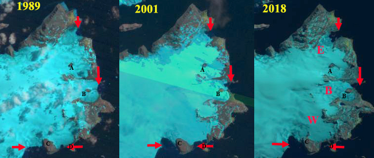
Warsaw Icefield, King George Island, Antarctica glacier retreat and nunatak expansion in 1989, 2001 and 2018 Landsat images. E=Ecology Glacier, B=Baranowski Glacier, W=Windy Glacier, 1989 terminus locations indicated by red arrows.  Point A & B are nunataks. 

The Arctowski Polish Research Station is located on a relatively large ice-free oasis northeast of the Warsaw Icefield on King George Island, Antarctica. The station is on Admiralty Bay where  Ecological monitoring has been conducted since the late 1970’s in order to determine the size and condition of populations of seabirds and pinnipeds. The ocean bottom has had over 800 distinct benthic species identified. A long term study of a chinstrap penguin colony on King George Islands during the last 30 years indicates the size of the breeding populations has decreased by 84% probably due to limitations of the marine food web (Korczak-Abshire et al 2012). The outlet glaciers of Warsaw Icefield experienced significant retreat and mass loss (Petlicki et al, 2017). Here we examine Landsat images from 1989 to 2017 to illustrate the changes.  The Warsaw Icefield extends from 400 m to sea level.

In 1989 Baranowski and Windy Glacier terminate on the coastline lacking any significant embayment.  Ecology Glacier has a wide front in a shallow embayment.  Nunataks A and B are amidst the icefield. In 1990 the snowline is at 200 m with nunatak A and B in the ablation zone.  In 2001 nunatak A and B are still surrounded by ice.  Windy Glacier and Baranowski Glacier have retreated with embayments forming.  The embayments are separated from ocean by a coastal strip of land.  An embayment has also opened to the west of Windy Glacier and Point C due to glacier retreat. In 2005 the snowline is at 250 m.  Baranowski glacier retreat has led to Nunatak B reaching the margin of the glacier, the embayment expanding on the north side of the margin. In 2014 Ecology Glacier has retreated opening the embayment.  In 2018 Ecology Glacier has retreated 600 m since 1989 exposing several small new islands in this protected embayment.  the Tidewater front is quite limited in 2018. Nunatak A is within 400 m of the edge of the icefield, whereas in 1989 the nunatak was 1.2 km from the margin. The 1989-2018 500 m retreat of Baranowski Glacier has led to the development of a dominantly land based terminus. Windy Glacier has retreated 400 m since 1989 and is now land terminating. The glacier to the west of Windy Glacier and Point C has opened a 0.5 square kilometers embayment. The retreat of Warsaw Icefield is similar to that of Endurance Glacier, Elephant Island.  Petlicki et al,( 2017) indicate mass balance has not been as negative from 2012-2016 which should slow retreat.  The new embayments offer potential new locations for penguins that Arctowski scientists will monitor.

Warsaw Icefield, King George Island, Antarctica glacier retreat and nunatak expansion in 1990, 2005 and 2014 Landsat images. E=Ecology Glacier, B=Baranowski Glacier, W=Windy Glacier.  Point A & B are nunataks in 1989. 

Map from the Arctowski Research Station in 2007 indicating glacier changes from 1978 mapped margins to 2007 dark line margin.  This dark line has been annotated to be visible for this post. 

Hindle Glacier Rapid Retreat Continues, South Georgia

Hindle Glacier comparison in 1989, 2015 and 2017 Landsat images.  Red arrow is 1989 terminus, pink arrow the 2015 terminus and red arrow the 2017 terminus location. 

South Georgia is south of the Polar Front preventing any truly warm season from persisting. The cool maritime climate leads to numerous glaciers covering a majority of the island and quite low equilibrium line altitudes.  Hindle Glacier enters Royal Bay on the east coast of South Georgia Island.  The British Antarctic Survey (BAS) has been the principal research group examining glacier change on South Georgia Island.  Cook et al (2010) and Gordon et al (2008) have emphasized that there is a pattern island wide with many calving glaciers having faster retreat.  Gordon et al., (2008) observed that larger tidewater and calving outlet glaciers generally remained in relatively advanced positions from the 1950’s until the 1980s. After 1980 most glaciers receded; some of these retreats have been dramatic and a number of small mountain glaciers will soon disappear.   The change in glacier termini position have been documented by Alison Cook at British Antarctic Survey in a BAS retreat map, she identified that 212 of the Peninsula’s 244 marine glaciers have retreated over the past 50 years and rates of retreat are increasing.   Here we examine Landsat imagery from 1989 to 2017 to identify the rapid retreat rate. NASA Earth has piggy backed on this assessment, with excellent imagery.

For Ross-Hindle the retreat was minimal from 1960 to 1989 with the glaciers joined   In 1989 the glaciers joined 2.5  km from the terminus. The glacier spanned Royal Bay with a 3.2 km wide calving front.  By 2002 the glacier front had retreated 800 m, but they were still joined. By 2008 the glaciers had separated due to an additional retreat of  1.4 km. The front was now retreating south up a separate embayment from Ross Glacier.  The calving front in 2008 was 1.6 km wide.  By 2015 further retreat led to the separation of Hindle from an eastern Tributary at the first prominent headland in the fjord, a 1.6 km retreat in seven years.  By 2017 an additional 600 m of retreat had occurred with total retreat of  4.4 km in 28 years.  This is a rate of over 150 m/year, which is an exceptional rate.  The exceptional retreat rate of Hindle Glacier suggests that Ross Glacier acted as a pinning point stabilizing the terminus reach of the glacier.  The low surface slopes in 2017 for the lowest 3 km of the glacier suggest the fjord head is at least 3 km south of the present terminus and  the calving retreat will continue until the head of the fjord is reached. This location is close to the origin of the medial moraine that runs right to the glacier front currently. This embayment will open up new areas for Gentoo Penguins and elephant seals to immigrate into.  Levy et al (2016) discuss the shift and dispersal of colonies in the region, that climate change is an important driver of.

Map of terminus retreat of Ross and Hindle Glacier from the BAS.  Green Pin Locations are Gentoo Penguin colonies. 

2002 Landsat image of Hindle Glacier.  Red arrow is 1989 terminus and yellow arrow the 2017 terminus location. 

Hindle Glacier 2016 Landsat image.  Red arrow is 1989 terminus and red arrow the 2017 terminus location. 

Location of South Georgia versus atmospheric and ocean circulation features (From South Georgia Future Science).