Herz Glacier, South Georgia Loses 25% of its Length 1989-2021

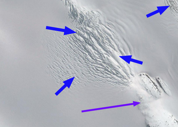
Landsat images from 1989-2021 of Herz Glacier.  Red arrow is 1989 terminus location, yellow arrows the 2021 terminus location. I=Iris Bay.

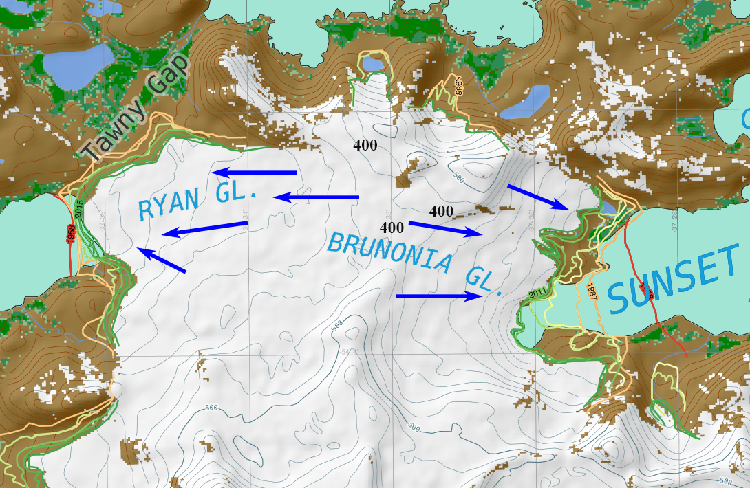
Herz Glacier is on the southeast coast of South Georgia Island, and is adjacent to the Twitcher Glacier. The terminus change of this tidewater glacier ending in Iris Bay was completed by the British Antarctic Survey for the 1960-2011 period, see map below (Gordon et al, 2008). This map indicates the slow retreat from 1960-1988 and a more rapid retreat since. Here we utilize Landsat imagery from 1989-2021 to examine terminus change.

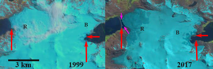
In 1989 the glacier is 10 km long with the terminus located in the east trending arm of Iris Bay at a point where it widens substantially. Point A is the midway point of the glacier.  By 2002 the terminus has retreated ~1.1 km to Point B in a narrower portion of the fjord.  The calving front is 0.9 km wide in 2002.  By 2009 the glacier had retreated 1.8 km on the north side of the fjord and  2.2 km on the south side. The overall 2 km retreat is a rate of 100 meters/year and is 20 % of the total glacier length (Pelto, 2017). By 2015 the terminus has retreated into an even narrower portion of the fjord, which would reduce calving.  The snowline in both 2002 and 2015 is ~1000 m. In 2021 the terminus has continued to recede and could be nearing the head of the fjord. The snowline in 2021 is somewhat above 1000 m in the early March landst image.

The retreat has been 2.5 km in the 32 year period from 1989-2021, a rate of  78 m/year.  The glacier is nearing the inland end of the ridge separating Herz from Twitcher.  As both Twitcher Bay and Iris Bay have expanded there are certainly new locations for both elephant seal and penguin colonies (BAS, 2018). The retreat of this glacier is comparable to that of other South Georgia glaciers noted by NASA Earth Observatory; Neumayer Glacier, Twitcher Glacier and Hindle Glacier.

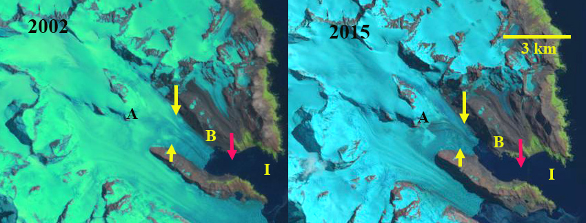
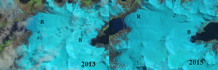
Landsat images from 2002 and 2015 of Herz Glacier.  Red arrow is 1989 terminus location, yellow arrows the 2021 terminus location. I=Iris Bay.

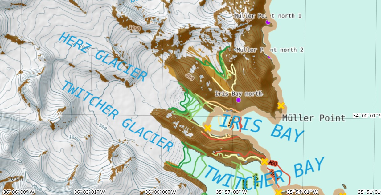
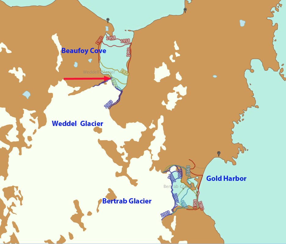
Map of Herz Glacier area from the British Antarctic Survey, illustraing glacier front changes 1988-2011. Yellow crosses mark elephant seal beaches and purple dots penguin colonies, which can expand to new locations in this opening fjord.

Nordenskjold Glacier, South Georgia Retreat Accelerates

Nordenskjold Glacier in 1993 and 2019 Landsat images.  Red arrow is the 1989 terminus location, yellow arrows the 2019 terminus location. Purple arrow is a tributary that has separated. Point #1 and #3 is expanding bedrock ribs.  Point #2 is an impounded glacial lake.

Nordenskjold Glacier is a tidewater glacier flowing into Cumberland East Bay on the east coast of South Georgia, Island.  Cook et al (2010) and Gordon et al (2008) noted a pattern island wide with many calving glaciers having the fastest retreat.  Gordon et al., (2008) observed that larger tidewater glaciers remained in relatively advanced positions from the 1950’s until the 1980’s, followed by significant recession,  this retreat was delayed on Nordenskjold Glacier until 2000. The map below from the British Antarctic Survey indicates the slow retreat from 1957-1998 and a more rapid retreat since. Here we use Landsat imagery from 1989-2019 to identify changes.

In 1989 the glacier terminated at approximately the same location as in 1957. Vegetation extended quite close to the terminus with a minimal trimline or recently deglacated zone evident. At Point #1 and #3 are bedrock ridges that generate medial moraines. At Point #2 is a glacial lake impounded by a secondary terminus. At the purple arrow is a tributary glacier joining the main glacier. By 1993 there has been a limited retreat exposing some newly deglaciated unvegetated terrain adjacent to the shoreline and glacier terminus. There was limited additional retreat up to 2000. This is unusual as the neighboring glaciers had all retreated substantially by 2000. By 2016 the glacier had retreated substantially, ~900 m. The tributary at the purple arrow no longer reaches the main glacier. At Point #2 the impounded lake has expanded slightly and is open water. The snowline is also at 500 m above Point #1 and #3.  In 2019 the snowline is again above 500 m. The area of bedrock at Point #1 and #3 has expanded significantly indicating glacier thinning, and greater ablation at this elevation. The terminus has retreated an average of 1250 m from 1989-2019. There is a significant trimline and recently deglacited terrain on the western shore of the bay.

The retreat is much less than on Neumayer, Twitcher or Hindle Glacier. The upglacier thinning suggests this process will continue, with a 3.2 km wide calving front in water of unknown depth calving will continue to be a key driver of retreat.

Nordenskjold Glacier in 1989 and 2016 Landsat images.  Red arrow is the 1989 terminus location, yellow arrows the 2019 terminus location. Purple arrow is a tributary that has separated. Point #1 and #3 is expanding bedrock ribs.  Point #2 is an impounded glacial lake.

Map of terminus change from the British Antarctic Survey map platform

Ryan Glacier, South Georgia Retreats from Tidewater

Ryan (R) and Brunonia Glacier (B) in 1999 and 2016 Landsat images.  Red arrows indicate the 1999 terminus and pink arrows a new proglacial lake. 

Ryan Glacier and Bunonia Glacier span the width of South Georgia near its northwestern tip.  Brunonia Glacier flow east and terminates in Sunset Fjord and Ryan Glacier flows to the west into Ice Fjord, which seems more viable as a “Sunset” Fjord.  The glacier divide is a very low 400 m.  The British Antarctic Survey (BAS) has generated an excellent online map of South Georgia that includes many layers including glacier frontal change since 1958 in this region.  BAS work by Cook et al (2010) and Gordon et al (2008) have emphasized that there is a island wide pattern of calving glaciers having faster retreat.  Gordon et al., (2008) observed that larger tidewater and calving outlet glaciers generally remained in relatively advanced positions from the 1950’s until the 1980’s. After 1980 most glaciers receded; some of these retreats have been dramatic a such as Hindle and Neumayer.   Here we examine 1999-2016 Landsat imagery to identify glacier change. 

In 1999 Ryan Glacier reaches tidewater across a 1.2 km glacier front.  Brunonia Glacier terminates in Sunset Fjord pinned on what is a bedrock prominence under the ice. In 2013 and 2015 Landsat imagery from early in the melt season indicates the melt zone is below 200 m. In 2015 it is evident that Ryan Glacier no longer reaches tidewater.  In 2016 Ryan Glacier is separated from Ice Fjord by a barrier beach and a narrow developing proglacial lake, pink arrow.  The glacier has retreated 200 m since 1999.  Brunonia Glacier has experienced a 400 m retreat exposing 2 new peninsulas.  The first is on the north side of the fjord and the other is mid glacier. Both had been under the ice in 1999. The snowline in 2016 on Ryan Glacier is also higher reaching 250 m in mid-February.  Retreat of Ryan Glacier from 1958 to 1999 was 100 m, while the retreat on Brunonia in the same period was 700-800 m.

British Antarctic Survey map of frontal change 1958-2015.

Ryan and Brunonia Glacier in 2013 and 2015 Landsat images. The 2015 image indicates Ryan Glacier is no longer tidewater. 


Weddel Glacier Thinning-Retreat, South Georgia Island

Weddel Glacier is on the southeast coast of South Georgia Island.  It terminates in Beaufoy Cove just north of Gold Harbor.The change in glacier terminus position has been documented by Alison Cook at British Antarctic Survey in a BAS retreat map.  In 1958 it reached within 400 m of the coast at the outlet of Beaufoy Cove. Gordon et al., (2008) observed that larger tidewater and sea-calving valley and outlet glaciers generally remained in relatively advanced positions until the 1980s. For Weddel Glacier the retreat was rapid from 1960 to 1974 and was slow from 1992-2003.  Here we examine Landsat imagery from 1989 to 2015 to visualize and update this change.
bertrab ge
Google Earth Image

weddell-bertrab map
BAS map of glacier terminus position

In 1989 the glacier terminates near the tip of a peninsula, red arrow in each image. The calving front extends southeast, orange dots. At the yellow arrow the glacier fills a small side valley adjacent to the main glacier. At the purple arrow is a small extension of the main icefall flowing down the bedrock step.
In 2002 there is only minor retreat at the red and yellow arrow, but thinning has led to the small extension of the main icefall being almost cutoff by bedrock. By 2015 the glacier has retreated 200-300 meters from the 1989 position and the main terminus is narrower. At the yellow arrow the side valley no longer has ice. At the purple arrow this is just bedrock now, there is no glacier extension flowing down the bedrock step. A close up the icefall in a 2009 Google Earth image indicates both the extensive crevassing but also the lack of glacier ice at the purple arrow, where an extension of the icefall formerly flowed. A Google Earth closeup of the terminus indicates that only a small section is still in contact with Beaufoy Cove in 2009, with land exposed at the orange arrows. This glacier is almost not tidewater and has terminated in shallow water since 1989, which helps explain a slower rate of retreat. The glacier has thinned more rapidly than it has retreated in the last 25 years. The retreat rate is less than nearby Bertrab Glacier, Konig Glacier and Neumayer Glacier on the same coast of South Georgia.

weddel glacier 1989

Landsat Image 1989

weddell glacier 2002

Landsat image 2002

weddel glacier 2015
Landsat image 2015

weddel icefall
Google Earth icefall image
weddel terminus
Google Earth 2009 image