East Twin Glacier Retreats from Twin Lake with Developing Icefield Disconnection

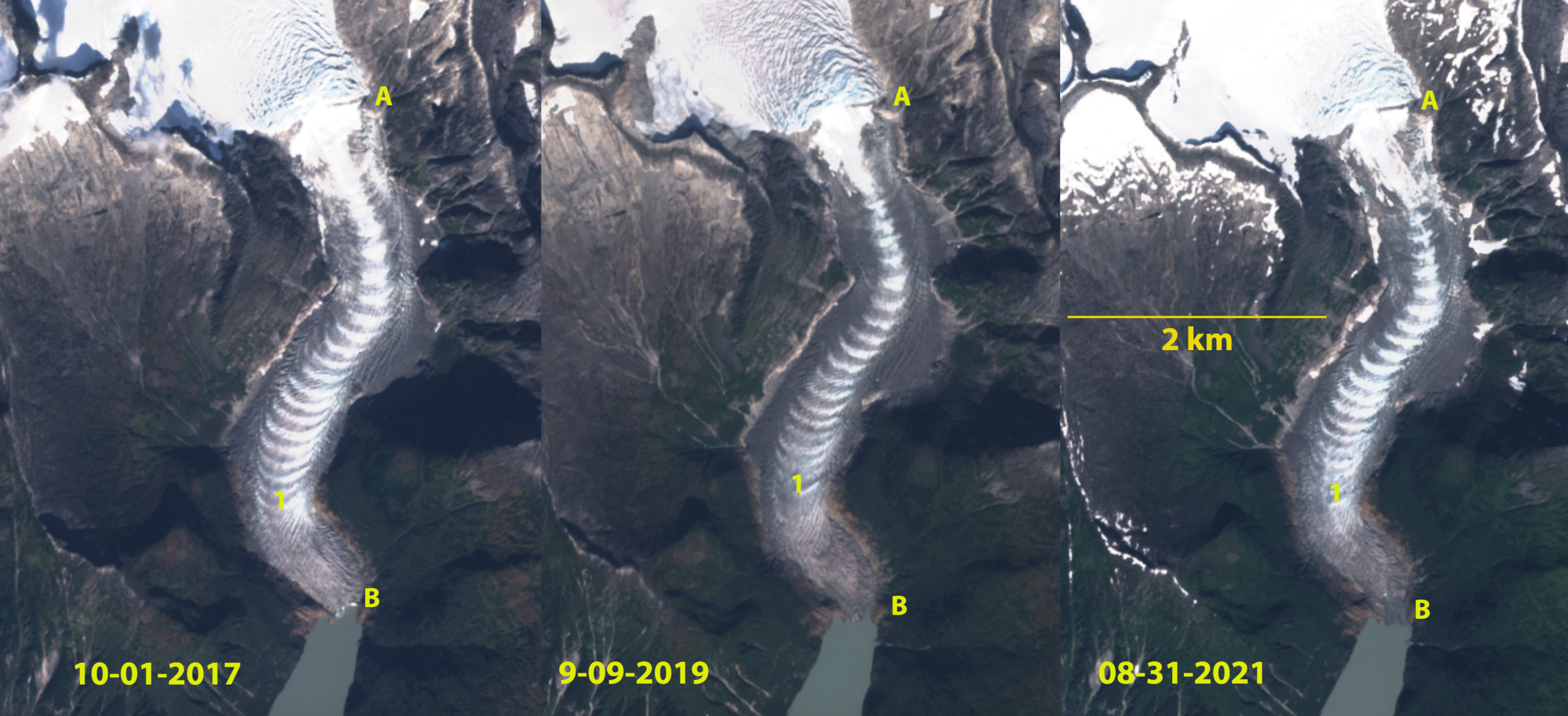
East Twin Glacier in Sentinel 2 images from 2017, 2019 and 2021. Point A marks the threshold, B the terminus contact with lake in 2017, Point 1 is the first ogive above the terminus.

East Twin Glacier is a narrow valley outlet glacier from the Juneau Icefield.  The glacier descends from the icefield through an icefall at 975 m- 600 m that generate ogives at the icefall base. The extensive crevassing begins at 975 m with a threshold at 900 m.  Davies et al (2022) examination of the Juneau Icefield found 63 glaciers had disappeared since a 2005 inventory, with a 10% reduction of glacier area. This study noted the importance of glacier disconnections occurring which separates the accumulation and ablation zones,  leading to stagnation of the glacier segment below.  We found 176 such disconnections in the outlet and valley glaciers of the Juneau Icefield Davies et al (2022). The focus of this post is on the development of a disconnection on the main stem of the East Twin Glacier.

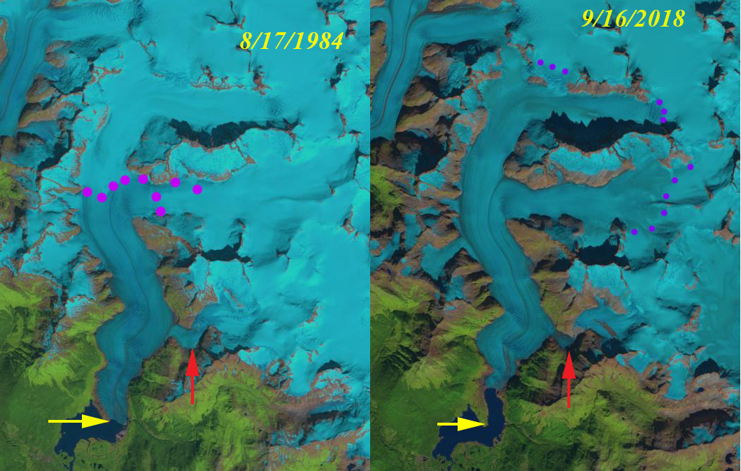
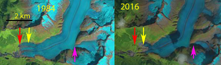
In 1984 I had a chance to complete mass balance observations on the glacier.  The terminus in the lake was 600 m wide,  and the threshold at 900 m was also 600 m wide in 1984. The glacier retreated 900 m from 1984 to 2015 (Pelto, 2017). The terminus has calved into Twin Lake for over a century, but by 2015 the width of the terminus calving into the lake has declined by 75% since 1984, to 150 m. In 2017 there is still a very narrow steepened calving front. By 2019 the terminus no longer has a calving front, but was in contact with the lake.  By 2021 the glacier terminates 200 m from the lake on the west side and 100 m from the lake on the east side. The total retreat from 1984-2021 is 650 m.  In 2018 the snowline reached ~1250 m, 300 m higher than the long term average.  In 2019 the snowline again reached this level. The result is an accelerated reduction in accumulation flowing towards the top of the icefall, along with glacier thinning at the threshold, which enables the disconnection to rapidly develop. The high snowline elevations and exceptional melt in 2018 and 2019 helped to further narrow the glacier at the threshold to 240 m in 2021. The bedrock threshold is quickly cutting across the glacier, this is limiting flow through the icefall and may have shut off the production of new ogives.

The declining mass balance of the Juneau Icefield indicated by the high snowlines is driving thinning, disconnections and  retreat (Pelto 2019).

East Twin Glacier in 2018 and 2019 the highest snowlines since observations began on the Juneau Icefield in 2018. Snowline is the purple dots at 1250-1275 m, well above the threshold at Point A which had just below the mean 950 m snow line position from 1946-2000. 

East Twin Glacier terminus change from 1984-2021 in Landsat images. Red arrow is the 1984 terminus, yellow arrow the 2021 terminus.

Mendenhall Glacier, Alaska Accumulation Zone Shrinks

Mendenhall Glacier in Landsat images from 1984 and 2018.  Yellow arrows indicates 1984 terminus location, read arrow the Suicide Basin tributary and the purple dots the snowline.

Mendenhall Glacier is the most visited and photographed terminus in the Juneau Icefield region. The glacier can be seen from the suburbs of Juneau.  Its ongoing retreat from the Visitor Center and the expansion of the lake it fills is well chronicled.  Here we document the rise in the snowline on the glacier that indicates increased melting and reduced mass balance that has driven the retreat.  The change in snowline from 1984-2018 and the associated retreat are documented. The snowline as July begins in 2019 is already in the end of summer range.  In 1984 I had a chance to ski across the upper portion of this glacier. Photo736861842897_inner_76-402-615-387-84-752-620-741

Top of the Mendenhall Glacier at 1500 m looking towards ocean in 1984.

Mendenhall Lake did not exist until after 1910, in 1948 it was 2.2 km across and by 1984 the lake was 2.7 km across.  Boyce et al (2007) note the glacier had two period of rapid retreat one in the 1940’s and the second beginning in the 1990’s, both enhanced by buoyancy driven calving. The latter period has featured less calving particularly in the last decade and is a result of greater summer melting and a higher snowline by the end of the summer, which has averaged 1250 m since 2003 vs 1050 m prior to that (Pelto et al, 2016).  In 2005, the base of the glacier was below the lake level for at least 500 m upglacier of the terminus (Boyce et al (2007).  This suggests the glacier is nearing the end of the calving enhanced retreat.  It is likely another lake basin would develop 0.5 km above the current terminus, where the glacier slope is quite modest.

Photo736861827670_inner_51-268-606-268-57-633-606-633

Terminus of Mendenhall Glacier before the 1982 field season on the Juneau Icefield.

The glacier in 1984 ended at the tip of a prominent peninsula in Mendenhall Lake. The snowline is at 950 m. In 1984 with the Juneau Icefield Research Program we completed both snowpits and crevasse stratigraphy that indicated retained snowpack at the end of summer is usually more than 2 m at 1500-1600 m. The red arrow indicates a tributary that joins the main glacier, where Suicide Basin, currently forms. In 2014 the snowline in late August  is at 1050 m.  The terminus has retreated to a point where the lake narrows, which helps reduce calving. In 2015 the snowline is at 1475 m.  In  2017 the snowline reached 1500 m.  There is a small lake in Suicide Basin. In September 2018 the snowline reached 1550 m the highest elevation the snowline has been observed to reach any year.  In Suicide Basin the lake drained in early July. In 2018 Juneau Icefield Research Program snowpits indicates only 60% of the usual snowpack left on the upper Taku Glacier, near the divide with Mendenhall Glacier. On July 1. 2019 the snowline is already as high as it was in late August of 1984.  This indicates the snowline is likely to reach near a record level again.  The USGS and NWS is monitoring Suicide Basin for the drainage of this glacier melt filled lake. In 2019 the lake rapidly filled from early June until July 8, water level increasing 40 feet.  It has drained from July 8 to 16 back to it early June Level. The high melt rate has thinned the Mendenhall Glacier in the area reducing the elevation of the ice dam and hence the size of the lake in 2019 vs 2018.

The snowline separates the accumulation zone from the ablation (melting) zone and the glacier needs to have more than 60% of its area in the accumulation zone.  The end of summer snowline is the equilibrium line altitude where mass balance at the location is zero. With the snowline averaging 1500 m during recent years this leaves less 30% of the glacier in the accumulation zone. This will drive continued retreat even when the glacier retreats from Mendenhall Lake. The declining mass balance despite retreat is evident across the Juneau Icefield (Pelto et al 2013).  Retreat from 1984-2018 has been 1900 m.  This retreat is better known, but less than at nearby Gilkey Glacier and Field Glacier.

Mendenhall Glacier in Landsat image from 2014.  Yellow arrows indicates 1984 terminus location and the purple dots the snowline.

Mendenhall Glacier in Landsat image from 2015.  Yellow arrows indicates 1984 terminus location and the purple dots the snowline.

Mendenhall Glacier in Landsat image from 2017.  Yellow arrows indicates 1984 terminus location and the purple dots the snowline.

Mendenhall Glacier in Landsat image from 2019.  Yellow arrows indicates 1984 terminus location and the purple dots the snowline.

Meade Glacier, Alaska 4 km Retreat 1986-2018

Meade Glacier in Landsat images from 1986 and 2018.  The red arrow indicates the 1986 terminus, pink arrow the 2014 terminus, yellow arrow the 2018 terminus, orange arrows tow tributaries to Meade Glacier and the purple dots the snowline.

Meade Glacier drains the northwest portion of the Juneau Icefield, with meltwater entering the Katzehin River and then Chilkoot Inlet. The glacier begins in British Columbia and ends in Alaska. Here we use Landsat imagery to examine changes in the glacier from 1986 to 2018. The glacier experienced a slow continuous retreat from 1948 to 1986 of 400 m, with the glacier ending on an outwash plain.

In 1986 the terminus is indicated by a red arrow, the snowline is at 1250 m in 1986, there is no evident lake at the terminus of glacier just an expanding outwash plain. Both tributaries from the south, orange arrows, are 750 m+ wide where they join Meade Glacier. By 2004 a 400 m long proglacial lake has formed at the terminus. The two tributaries from the south, at the orange arrows, no longer are connected to the glacier. The snowline is at 1450-1500 m. In 2014 the proglacial lake is 3.5 km long, the entire lower 2.5 km of the glacier has collapsed since 2004. There is still considerable relict ice floating in the lake. There is a substantial lake along the southern margin of the glacier where a tributary streams enters the main valley. This indicates the glacier will quickly retreat to this point by further collapse into the lake.  The snowline in 2014 is at 1450 m on Aug. 2, the date of the imagery, the high snowline ensures continued mass loss and glacier retreat.  By 2018 Mead Glacier has retreated 4.1 km since 1986.  The snowline is at 1450 m on October 2, when fall snow should have already begun.  A third tributary entering the glacier from the east at 1200 m no longer reaches the main stem.  Based on surface slope changes the glacier appears to be within 1 km of the inland limit of the proglacial lake.  The inland limit should be near the prominent bedrock knob on the south side of the glacier a short distance inland of the current terminus. When this is reached the glacier retreat will be reduced.  The retreat parallels that of most Juneau Icefield glaciers including the next glaciers to the south Field Glacier and Gilkey Glacier.  The glacier shares a divide with Warm Creek Glacier that terminates in British Columbia that is also retreating rapidly in an expanding lake.

Meade Glacier in Landsat image from 2004.  The red arrow indicates the 1986 terminus, pink arrow the 2014 terminus, yellow arrow the 2018 terminus, orange arrows tow tributaries to Meade Glacier and the purple dots the snowline.

Meade Glacier in Landsat image from 2014.  The red arrow indicates the 1986 terminus, pink arrow the 2014 terminus, yellow arrow the 2018 terminus, orange arrows tow tributaries to Meade Glacier and the purple dots the snowline.

Meade Glacier in Landsat image from 2018.  The red arrow indicates the 1986 terminus, pink arrow the 2014 terminus, yellow arrow the 2018 terminus, orange arrows tow tributaries to Meade Glacier and the purple dots the snowline.

Herbert Glacier Retreat, Alaska 1984-2016

herbert compare 2016

Comparison of Herbert Glacier terminus position in Landsat images from 1984 and 2016. Red arrow 1984 terminus, yellow arrow 2016 terminus and pink arrow a tributary that has separated. 

Herbert Glacier drains the west side of the 4000 square kilometer Juneau Icefield in Southeast Alaska.  It is the glacier just north of the more well known Mendenhall Glacier and just south of Eagle Glacier.  It is also the first glacier I ever visited, July 3, 1981 during my first field season with the Juneau Icefield Research Program.  Here we examine the changes from the August 17, 1984 Landsat 5 image to a Sept. 1, 2016 Landsat 8 image.

The glacier descended out of the mountains ending on the coastal plain in 1948.  In 1984 we examined the terminus of this glacier, which was in the small proglacial lake at 150 m.  Herbert Glacier has retreated 600 m since 1984.  The width of the terminus has also declined. The pink arrow indicates a tributary that no longer feeds the main glacier.  The retreat has not been enhanced by iceberg calving as is the case at Mendenhall Glacier. The overall retreat is also less than Eagle Glacier. In the Google Earth images below from 2005 and 2013 the retreat is 200 m, the terminus has fewer crevasses in 2013 suggesting a reduced velocity and faster retreat to come. The annual equilibrium line on the glacier has averaged 1150 m from 2003-2016. By contrast in August 1984 I skied to the top of the icefall and could see the snowline was at 1000 m. This leaves the glacier with an AAR of 0.45, too low to sustain equilibrium, retreat will continue. In 2015 and 2016 the snowline rose to over 1400 m by the end of the melt season, indicating two years of large mass loss, which will drive further retreat. The higher snow line elevation has been observed across the icefield Pelto et al (2013).herbert tsl

Transient snow line in Early Sept. of 2015 and 2016.  The snow line is at the top of the icefalls, at 1400-1450 m. 

herbert 2005

2005 Google Earth Image, red line is 2005 margin, yellow line is 2013.

herbert 2013 ge

2005 Google Earth Image, red line is 1984 margin, yellow line is 2005.herbert glacier 2012

Herbert Glacier Terminus in 2012 

Meade Glacier Rapid Retreat 1986-2014, Alaska

Meade Glacier drains the northwest portion of the Juneau Icefield, with meltwater entering the Katzehin River and then Chilkoot Inlet. The glacier begins in British Columbia and ends in Alaska. Here we use Landsat imagery to examine changes in the glacier from 1984 to 2014. The glacier experienced a slow continuous retreat from 1948 to 1986 of 400 m, the glacier ended on an outwash plain. From 1991-2006 JAXA’s EROC program noted a retreat of 570 m, retreating into a lake basin. In 2007 the lower 2.5 km of the glacier was stagnant and heavily crevasses, poised for collapse in a developing proglacial lake. The 1948 map of the glacier indicates no proglacial lake with the glacier terminating on an outwash plain.
meade map
USGS Topographic map from 1948 aerial photographs

In 1986 the terminus is indicated by an orange arrow, the 2014 terminus by a red arrow, two tributaries that connect to the Meade Glacier are indicated by yellow arrows and the snowline at is indicated by purple dots. The snowline is at 1250 m in 1986, there is no evident lake at the terminus of glacier just an expanding outwash plain. Both tributaries are 750 m+ wide where they join Meade Glacier. By 2004 a 400 m long proglacial lake has formed at the terminus. The two tributaries from the south at the yellow arrows no longer are connected to the glacier. The snowline is at 1450-1500 m, which is much higher than in 2004 on Taku Glacier or Brady Glacier. In 2009 the snowline is at 1400 m, the proglacial lake has expanded to 600 m in length. In 2014 the proglacial lake is 3.5 km long, the entire lower 2.5 km of the glacier has collapsed since 2007. There is still considerable relict ice floating in the lake. There is a substantial lake along the southern margin of the glacier where a tributary streams enters the main valley. This indicates the glacier will quickly retreat to this point by further collapse into the lake. The snowline in 2013 and 2014 was quite high and the summer’s quite warm which aided in the lake expansion. The snowline in 2014 is at 1400 m on Aug. 2, the date of the imagery, the high snowlines ensure continued mass loss and glacier retreat. There was still six week of summer melting remaining on the date of the imagery. The Meade Glacier is poised to continue a rapid retreat in the near future its retreat parallels that of most Juneau Icefield glaciers including the next glaciers to the south Field Glacier and Gilkey Glacier.

meade glacier 1986
1986 Landsat image
meade 2004
2004 Landsat image
meade glacier 2009
2009 Landsat image

meade glacier 2014
2014 Landsat Image

Hoboe Glacier retreat, British Columbia

The Hoboe glacier is a distributary tongue of the Llewellyn Glacier draining the Juneau Icefied in Northwest Britsh Columbia. In 1984 I had the opportunity to hike the length of the glacier carrying supplies to the terminus for a master thesis research project of Richard Campbell at the Univ. of Idaho, during the JIRP summer field season. The glacier is 4 km long separating from the Llewellyn Glacier at 3800 feet and ending at approximately 3000 feet. This is our view from the glacier surface notice the evident trimline above the ice surface showing how thick the glacier used to be.This glacier has receded 2200 meters since early visitors to the area mapped its terminus around 1910, and 3900 m from its maximum advance of the Little Ice Age. The Google Earth views below are from 2001 images. The glacier has retreated 450-500 m in the fifty years that the Juneau Icefield Research Program has been examining it. The first view is looking up glacier and the next two looking down glacier. In all three a trimline is evident where vegetation has not had time to develop due to retreat of the last 75 years. The image above is an aerial photograph taken by Don McCully of JIRP. The trimline in the photograph is 75-85 meters above the glacier surface indicating the thinning that has occurred in the last century. Nearly one meter a year due to the recent climate change that has enhanced summer melting and reduced winter snowfall. The Hoboe Glacier is continuing its retreat like all but one of the nineteen outlet glaciers of the Juneau Icefield. Including the Gilkey Glacier and Tulsequah Glacier.