

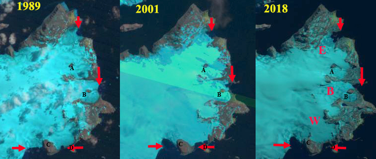
King George Bay Glacier retreat releases a new island (Point B) and expanded ice free oases in 1989 and 2022 Landat Images. Point A marks an area where the glacier had reached the coast until after 2005. Point B is the new island, Point C= new oasis, PI=Penguin Island, TP=Turret Point Oasis
King George Bay is on the southeast coast of King George Island. This coastline is comprised mainly of glacier margins ending in th sea, with limited ice free areas. The east end of the bay features the Turret Point Oasis, with Penguin Island just offshore. This oasis is a location used for breeding by Chinstrap and Adelie Penguins, and is a significant breeding area is for southern giant petrels, and Antarctic ‘blue-eyed’ shags. Elephant seals and fur seals are numerous in the latter part of the season (Korczak-Abshire,et al 2018). Here we examine Landsat images from 1989-2022 to identify changes in the glacier margin and the impact on this oasis and generation of a new island.

King George Bay Glacier retreat releases new island in Sentinel images from 2018 and 2022. Point A marks an area where the glacier had reached the coast until after 2005. Point B is the new island, Penguin Island=PI, TP=Turret Point, Point C is the new oasis.
In 1989 the Turret Point Oasis had an area of ~1 km². The King George Bay Glacier terminated on a bedrock rise at Point B. The glacier reached the coast between Turret Point and Point A. To the west there is no other ice free coastline, Point C. In 2005 the glacier was still terminating on the bedrock rise at Point B. The glacier is still reaching the coast between Point A and Turret Point and there is no ice free area near Point C. By 2018 there is a narrow finger of ice connecting to the Point B Bedrock rise and the shoreline between Turret Point and Point A is now free of glacier. there is a small strip of ice free coast near Point C. In 2022 the glacier has receded from the new island at Point B. The retreat at Point B is 950-1000 m since 1989, with a similar retreat across the broad front of the King George Bay Glacier to Point C. Glacier retreat from the shoreline near Point A has been 400 m. The Turret Point Oasis has expanded to 2 km², a doubling in size that expands oppportunity for greater diversity of flora and fauna. There is a new ~0.6 km² oasis that has formed at Point C. This is a narrow 200-400 m wide strip that is 1.7 km long. In the false color Sentinel images red indicates plant life for 12-24-2022 the Point C oasis does not have enough flora to be visible. This is in contrast to Turret Point and Penguin Island. The retreat here fits the pattern seen further west on King George Island on the Warsaw Ice Cap.
In 2016 the Arctwoski Station research survey found ~150 pairs of breeding Adlelie Penguins and 220 breeding pairs of southern giant petrels (Korczak-Abshire,et al 2018). In the Antarctic Treaty Turret Point oasis has specific visitor guidelines. The confluence of threats from climate change and human activity (Lee et al, 2022) makes Turret Point an important location to monitor. The retreat of glaciers opening up new potential breeding and feeding areas has been observed at Stephenson Lagoon on Heard Island and at Hindle Glacier on South Georgia.

Map illustrating locations bird and penguin species onTurret Point and Penguin Island from a UAV flight in 2016 from Korczak-Abshire,et al (2018)

King George Bay Glacier false color Sentinel image. Vegetation is evident on Turret Point=TP and Penguin Island=PI, but not at Poiunt C oasis.


