Blackfoot Glacier, Glacier National Park Slow Recession Indicates Persistence

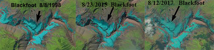
Comparison of Blackfoot Glacier in August Landsat images from 1998, 2015 and 2017

Blackfoot Glacier is the second largest glacier in Glacier National Park in Montana.  The glacier is on the north side of Mount Blackfoot and is close to two other glaciers Harrison and Jackson.  Glacier National Park over the last decade has initiated and maintained an extensive glacier monitoring program led by Dan Fagre.  This program has led to consistent mass balance observations on Sperry Glacier, repeat photography and repeat mapping.  The repeat mapping indicates the area lost from 1966 to 2015 (Fagre et al, 2017).  They identified that all glaciers lost substantial area, with Blackfoot Glacier falling into a small category of  seven glaciers that lost less than 20% of their total area in the last 50 years.  The glacier currently has an area of 1.5 square kilometers, a reduction of 18% since 1966 (USGS, 2017).  NASA (2016) provides a comparison of the glacier in 1984 and 2016. Here we examine Landsat and Google Earth imagery to better understand the slower change observed on this glacier.  The area lost to retreat on Blackfoot Glacier is similar to that on Harrison and Rainbow Glacier

In 1998 glacier volume losses were significant in the region, but in mid-August Blackfoot Glacier was still more than 60 % snowcovered, a significant area of accumulation.  In 2005 another year of minimum mass balance in the region the glacier had more than 60% snowcover in mid-August. In 2015 glacier volume losses in the region were again large, with Sperry Glacier having a loss of -1.22 m. Blackfoot Glacier still retained a significant area of accumulation, with more than 60% snowcover.  In 2017 the glacier is more than 90% snow covered on 8/12/2017 indicating that the glacier continues to maintain a significant accumulation zone.  This indicates the glacier is not as vulnerable to warming and will allow the glacier to continue to persist until 2050 at least. The key to retention of snowpack is high accumulation rates on the glacier, this allows snowpack to persist. Glaciers that lack a persistent accumulation zone, cannot survive current conditions (Pelto, 2010).

Blackfoot Glacier in 2005 Google Earth imagery, with margin in orange.

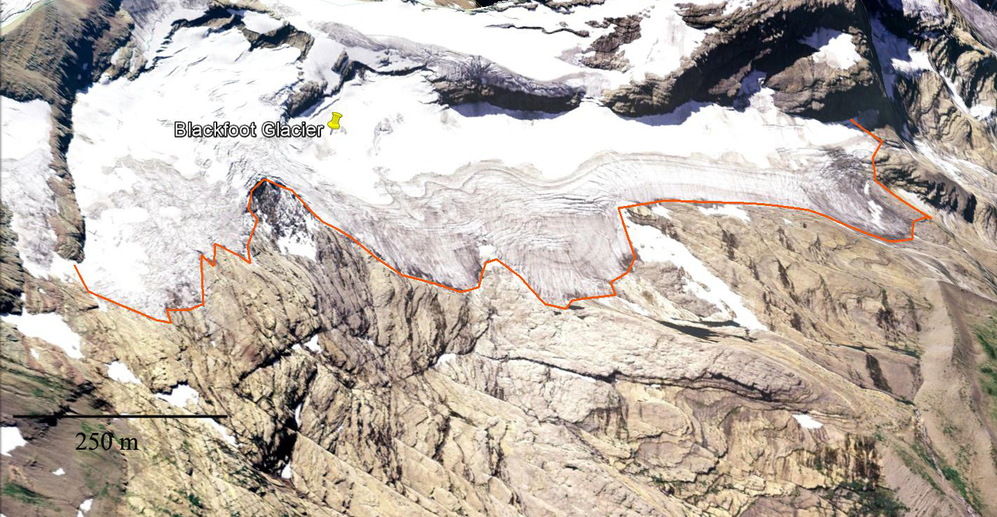
Blackfoot Glacier in 2015 Google Earth imagery, with 2005 margin in orange.  Note the limited retreat in this period. 


Hopper Glacier Retreat, will not survive

The Hopper Glacier is in the Beartooth Range of southwest Montana. The glacier is on the east side of Medicine Mountain and Sky Pilot Mountain. In 1966 the glacier in the USGS map ended at a lake marked simply as 10183 feet. The red line marks the mapped glacier boundary. The glacier comprise two parts, one from beneath Medicine Mountain that was smaller, and the larger section below Sky Pilot. By 1998 (top image) in this aerial image from the USGS the two parts are separate and the glacier has retreated 200 meters from the shores of the lake, the terminus is marked by the green line. By 2004 the northern section is gone. The southern section of the glacier remains thin and the lack of snow cover anywhere on the glacier in 1998 indicates the lack of a persistent accumulation zone (Pelto, 2010). glacier cannot survive without a persistent accumulation zone. This is similar to the nearby and similarly named Grasshopper Glacier. In 2004 (middle image) the glacier has undergone an additional 180 meters of retreat and considerable thinning exposing new areas of rock and moraine that had been beneath the glacier. The blue line is the 2004 terminus. The 2009 image is from early in the summer and snow remains on the glacier, but not much for June (bottom image). By the end of summer this glacier will lose all of its snowcover. A comparison with 1998 indicates a number of locations of moraine that are showing indicating the thinning and disappearance of glacier ice in the basin. The blue placemarks point such locations. The southern section has an area of 0.18 km2. The glacier has retreated 420 m since 1966 and has lost 70% of its total area. This pattern of disappearing glaciers is also evident in the Wind River Range, Wyoming for example Minor Glacier. The winter of 2011 has lots of snowpack even in late May and the Hopper Glacier will not experience much if any loss in area this summer. The nearby Monument Peak Snotel site at 8850 feet maintained by the USDA, on May 20th 2011 had 79 inches of snow depth with 29 inches of water content (snow water equivalent). This compares to snow water equivalent of 16 inches in 1998, 11 inches in 2004 and 24 inches in 2009 on that same date.

Old Sun Glacier Glacier National Park slow retreat

In Glacier National Park, MT all glaciers have been retreating. From 1850 to the present the number of glaciers has been reduced from 150 to 25. There are a few glacier such as Old Sun Glacier that have been retreating quite slowly since 1966 when the USGS maps were completed and are not disappearing anytime soon. Old Sun Glacier faces northeast and terminates at 8200 feet. This is a higher altitude than the rapidly shrinking Sperry Glacier, 7600 feet or Grinnell Glacier 6600 feet. A comparison of Google Earth images of Old Sun Glacier from the 1966 USGS map to 2009 indicate that the glacier has thinned and retreated but the majority of the glacier remains. The loss of area was noted as 12% from 1966-2005 and 14% by 2009. Below is the 1966 image, 1991 image, the strong brown line is the 1991 margin, 2003 image, 2005 image and the last two are 2009 images. The upper section of the glacier retains accumulation even in the poorest years such as 2009 and the glacier remains crevasses. The number of crevasses, slow recession and healthy accumulation zone point to a glacier that with present climate can be forecast to survive Pelto (2010). As long as a glacier maintains an accumulation zone it can survive at a reduced size. There are seven glaciers in Glacier National Park that have a consistent accumulation zone today each of these as a result is diminishing slowly,compared to the majority that have and will soon disappear.

Harrison Glacier, Glacier National Park Slow Recession

There continues to be a persistent misconception that all glaciers in Glacier National Park will be gone by 2030, I get asked that by journalists frequently and when I point out that is not the case they are surprised. An examination of 15 Glacier National Park glaciers using the recently published Alpine Glacier Survival Forecast method, indicates that 10 of the 15 glaciers are experiencing a disequilibrium response and will disappear, the other five have been shrinking little. A simpler and more visual look at the survival issue, illustrates why though they all are diminishing the glaciers will not all be gone by 2030. Blackfoot and Harrison Glacier are the two largest glaciers and show minimal changes in the accumulation zone. Both glaciers continue to retreat with the main termini retreating approximately 100-120 m since 1966. In this post we take a close look at the Harrison Glacier the most vigorous and slowest receding of the few remaining Glacier National Park glaciers. Key and Fagre (2003) utilized a model to construct the future of glaciers in the Blackfoot-Jackson watershed, and determined that all would be gone by 2030 with continued substantial warming, but not with limited additional warming. Based on the slow recession and equilibrium response of Blackfoot and Harrison Glacier to recent climate over the last 40 years these two glaciers are not going to disappear within the next 30 years. Harrison Glacier has according to the ongoing work of Northern Rocky Mountain Science Center (NOROCK) Has lost 9% of its areas between 1966 and 2005, a 40 year period. In the first image below the glacier is outlined in the 1966 map of Harrison glacier overlaid in Google Earth. The orange outline is left on the following three images all from Google Earth’s historic imagery files. The map indicates the area of crevasses above the main terminus. A look at the glacier over the last two decades indicates the glacier remains vigorous in terms of flow, as indicated by the many crevasses. In every image from 1991 second image to 2003 and 2005 last two images, even in these later summer images the glacier retains snowpack in its upper accumulation zone. This suggest a glacier that can survive current climate at a diminished size. The above images indicate the slow recent recession of the Harrison Glacier, which unlike the majority in the park is only slowly receding. This is in contrast to nearby Shepard Glacier and Grinnell Glacier which often are devoid of snow and are losing area at a rate of 10% per decade, four times that of Harrison Glacier. Why the difference? Most of the glaciers lay on the east or northeast slopes-lee side of the mountain ridges and have significant avalanching from the slopes above. Grinnell Glacier has a significant accumulation area at 7000 feet and Harrison Glacier at 9000 feet. Hence, the greater change in area as seen between the 1996 orange margin and 2006 recent margin for Grinnell Glacier