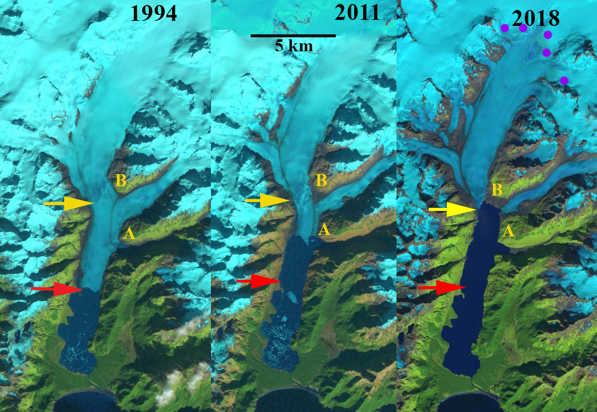
Excelsior Glacier retreat from 1994 to 2018 in Landsat images from 1994, 2011 and 2018. The red arrow is the 1994 terminus location and the yellow arrow is the 2018 terminus location. Point A and B are on the south and northwest side of the eastern tributary of the glacier.
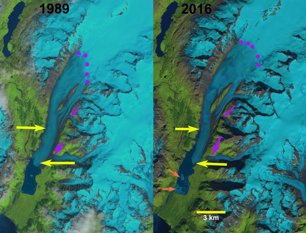
Excelsior Glacier is an outlet glacier of the Sargent Icefield, on the Kenai Peninsula of Alaska, that has terminated in an expanding Big Johnstone Lake since 1941. Here we examine the retreat of Excelsior Glacier from 1994-2018 using Landsat imagery. In 1909 the glacier ended on the strip of forested land between the lake and the ocean (Molnia, 2007). By 1950 the glacier had retreated 2 km from this strip of land creating the new lake (USGS-Molnia, 2008). This blog post is source of an article published by the Washington Post and from NASA Earth Observatory.
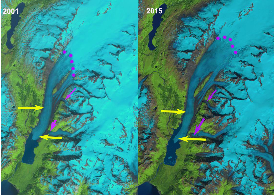
In 1994 the glacier was 21 km long and had retreated 5.5 km from the southern margin of Big Johnstone Lake, this is a rate of ~100 m/year since the lake began forming 1941. There is a glacier dammed lake just south of Point A named Excelsior Lake. By 2001 the glacier had retreated 800 m from the 1994 position, a rate of ~100 meters per year, and the glacier dammed lake south Point A remains, along with a few large icebergs. By 2011, the glacier had retreated beyond the former glacier dammed lake and ended at the prominent ridge just north of this former lake, adjacent to Point A, and the new inlet that replaces it. The glacier has retreated 2200-2500 m depending where on the front the measurement is made. By 2013 the glacier has retreated back to the junction of the two main tributaries between Point A and B. The snowline is at 900 m, with more than 80% of the glacier falling below the snowline. A calving Alaskan glacier typically needs at least 60% of its area above the snowline consistently to be in equilibrium. In 2011 and 2013 images there are large icebergs in Big Johnstone Lake indicating active calving. In 2018 the snowline is at 925 m again leaving an insufficient accumulation zone to support the glacier. Big Johnstone Lake has expanded to a length of 10.2 km, with an area of 18 km2. The glacier has retreated 4.7 km from 1994-2018, a rate of ~200 m/year, twice the previous rate. The eastern and western tributaries have now fully separated. Johnstone Adventure Lodge visited the eastern tributary, they call it Roan Glacier, glacier in May of 2019, the photograph they provided below indicates the glacier has receded from the lake. The glacier in 2018 is 15 km long having lost ~30% of its length in 24 years. Big Johnstone Lake is nearing its maximum size as the glacier surface slope steepens within 1 km of the current terminus, indicating a substantial increase in elevation of the base of the glacier. The lake width has changed little and is 1.4-1.8 km wide in the region the terminus has been retreating through during the last 25 years are has doubled from 9 to 18 km2. There will be a reduction in calving and retreat rate as the lake development nears completion, in 2018 for the first time there are no visible icebergs. Johnstone Adventure Lodge observed 15-20 harbor seals during their first visit to the glacier front in 2019, 10 of them had pulled out on icebergs. A reduction in icebergs will make the lake less attractive to harbor seals.
Excelsior Glacier follows the pattern of retreat of the neighboring Ellsworth Glacier and Pedersen Glacier of the Harding Icefield. This glacier is seen as a model for the impending retreat of Brady Glacier (Pelto et al, 2013).

Excelsior Glacier retreat from 1994 to 2018 in 1984 USGS map and Landsat images from 2001 and 2013. The red arrow is the 1994 terminus location and the yellow arrow is the 2018 terminus location. Point A and B are on the south and northwest side of the eastern tributary of the glacier.

“Roan Glacier” the eastern tributary of Excelsior Glacier in May 2019 now terminating on an outwash plain. Image from Johnstone Adventure Lodge.