Novosilski Glacier, South Georgia Retreat Causes Separation

Novosilski Glacier in Landsat images from 2020 and 2022. Note the retreat near Point A in particular. The terminus that extended from Point B-C developed an embayment reaching Point A.

Novosilski Glacier is a large tidewater outlet glacier on the west (cloudier) coast of South Georgia terminating in Novosilski Bay It shares a divide with the rapidly retreating Ross and Hindle Glacier on the east coast.  Gordon et al. (2008) observed that larger tidewater and calving outlet glaciers generally remained in relatively advanced positions from the 1950’s until the 1980s. After 1980 most glaciers receded; some of these retreats have been dramatic, such as at Neumayer Glacier. The west coast has featured much less retreat than the east coast.  The change in glacier termini position have been documented by Cook et al (2010) at British Antarctic Survey in a BAS retreat map,  identified that 212 of the Peninsula’s 244 marine glaciers have retreated over the past 50 years and rates of retreat are increasing. Pelto (2017) documented the retreat of 11 of these glaciers during the 1989-2015 period.  NASA Earth  piggy backed on the retreat of some east coast glaciers seen in Landsat images.

Novosilski Glacier in Landsat images from 2003 and 2022. Note the retreat from Point D  in 2003 to Point A in 2022  ed from Point B-C developed an embayment reaching Point A.

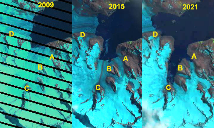
In 2003 Novosilski Glacier terminated in shallow water just east of a small island that acted as a pinning point, Point D.  By 2009 the glacier had retreated only a minor amount from this island into deeper water.  A rapid retreat ensued and by 2016 the glacier had retreated into a narrower fjord reach. The north and south margins featured remnant ice that was based above tidewater, Point B and C.  By 2016 the 2 km wide calving front had retreated 2.5 km from the 2003 position.  There was no significant retreat from 2016 to 2020.  By March of 2022 the glacier has retreated 1 km in the glacier center further leading to separation of the glacier into a northern and southern arm separated by the the Point A rock rib. The retreat also has led to a 6 km2 expansion of Novosilski Bay. The glacier slope at the terminus is steep and active, suggesting retreat may slow again.

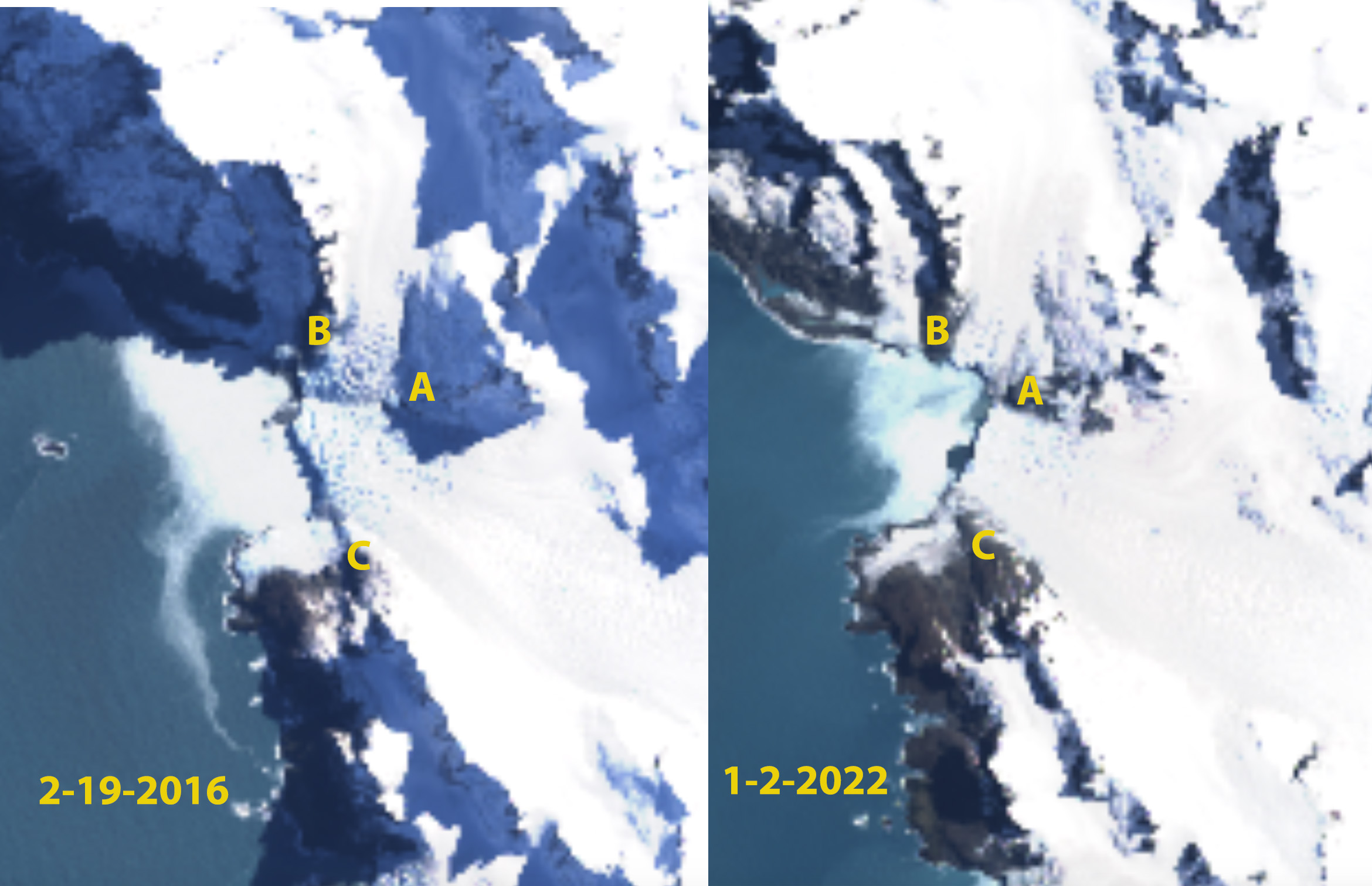
Novosilski Glacier in Landsat images from 2016 and 2022. Note the retreat near Point A in particular. The terminus that extended from Point B-C developed an embayment reaching Point A.


Hindle Glacier Retreat Causes Rapid Opening of Fjord, South Georgia

Hindle Fjord opening comparison in 2009, 2015 and 2021 Landsat images.  Point A is the northern tributary, Point B the middle tributary, Point C separates the eastern and western tributary and Point D is Ross Glacier.

Hindle Glacier enters Royal Bay on the east coast of South Georgia Island.  The British Antarctic Survey (BAS) has been the  examining glacier change on South Georgia Island, Cook et al (2010) noted a pattern island wide with many calving glaciers having the fastest retreat.  Alison Cook (BAS) identified that 212 of the Peninsula’s 244 marine glaciers have retreated over the past 50 years and rates of retreat are increasing.  In 2017 we examined Landsat imagery from 1989 to 2017 to identify the rapid retreat rate of Hindle Glacier. NASA Earth  piggy backed on this assessment, with excellent imagery, since the retreat rate has increased. Here we focus on the formation of the fjord from 2009-2021.

For Ross-Hindle Glaicer in 1989 the glaciers joined 2.5  km from the terminus spanning Royal Bay with a 3.2 km wide calving front.  By 2001 the glacier front had retreated 800 m, but was still a single joined calving front. By 2009 the glaciers had separated due to an additional retreat of  1.4 km. The Hindle Glacier front was now retreating south up opening a new separate fjord from Ross Glacier.  The calving front in 2009 was 1.6 km wide.  By 2015 a 1.6 km retreat led to the separation of Hindle from the northern tributary, Point A.  From 2015 to 2019 the main terminus retreated another 2.1 km, passed the middle tributary at Point B, to a prominent rock knob, Point C, separating the two main tributaries of the glacier with total retreat of  6.1 km in 30 years, an exceptional rate of over 200 m/year. The western tributary is at the head of the fjord and no longer calves significantly, while the eastern tributary has another 1 km to an increase in slopes that likely is close to head of the fjord. The new fjord is 4.5 km long and averages 1.1 km in width and has an area of 5.5 km2.  The northern tributary near Point A is also still calving and retreating.

This embayment opens up new areas for Gentoo Penguins and Elephant Seals to occupy. There are current colonies in Royal Bay and like at Moraine fjord, these two species are early colonizers of deglaciated terrain (see map below from BAS). In particular the beaches adjacent to the northern tributary, just north of Point B and northwest of Point A are wave protected and low slope.  Levy et al (2016) discuss that the southern Gentoo Penguins tend to remain within the same archipelago year around. They examined DNA from 39 Gentoo at Bird Island, adjacent to South Georgia, and found none were migrants.

Hindle Fjord in 2020 and 2021 Sentinel images indicating ongoing retreat at Point A and C, with a significant sediment plume from Point B in December 2020. Point A is the northern tributary, Point B the middle tributary, Point C separates the eastern and western tributary and Point D is Ross Glacier.

Hindle Glacier comparison in 2001, 2017 and 2019 Landsat images.  The red arrow is the 2001 glacier terminus. Point A is the northern tributary, Point B the middle tributary, Point C separates the eastern and western tributary and Point D is Ross Glacier.

British Anatarctic Survey map of Royal Bay area showing Elephant Seal beaches (yellow X) and Gentoo Penguin colonies (purple dots).

Risting Glacier, South Georgia Retreat Expands Drygalski Fjord

Risting Glacier right and Jenkins Glacier left in Landsat images from 2002, 2015 and 2016.  Red arrow is the 2002 terminus lcoation and yellow arrow at 2016 terminus location.  Dryglaski fjord extends southeast from the glaciers. 

Risting Glacier terminates in Drygalski Fjord on the southeast coast of South Georgia.  Risting and Jenkins Glacier were joined until the 1980’s.  Cook et al (2010) note the glacier had a relatively uniform retreat rate from 1955-1999 of 40 to 50 meters/year, with retreat increasing after 2000. (BAS map).   Gordon et al., (2008) observed that South Georgia’s larger tidewater and sea-calving valley and outlet glaciers generally remained in relatively advanced positions until the 1980’s, Risting Glacier was ahead of this timing in its retreat.

From 2002-2016 Risting Glacier retreated 1100 m, a rate of ~80 m/year twice the 1955-1999 rate. Jenkins Glacier retreated 500 m from 2002-2016 a rate of ~40 m/year.  In the Google Earth image below the slope of Jenkins Glacier suggests the glacier is near the head of the fjord. On Risting Glacier the steepest slope is 2 km behind the calving front, suggestive that the head of fjord is at that point. This location is exceedingly cloudy, making identification of the snowline difficult. The retreat hear is much less than Ross and Hindle Glacier just to the north.  The separation of Jenkins and Risting Glacier is like the separation of Konig and Neumayer Glacier  or Ross and Hindle Glacier.

From the British Antarctic Survey South Geogia GIS online viewer indicating terminus front positions.  Red arrows indicate 2002 positions and 2017 terminus is at yellow arrows.

Front of Jenkins glacier left and Risting Glacier above left, note extensive crevassing of Risting Glacier in particular.