Chickamin Glacier, Alaska Retreat Generates Separation and Lake Expansion

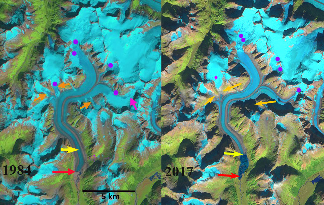
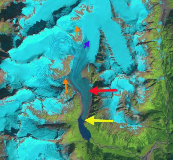
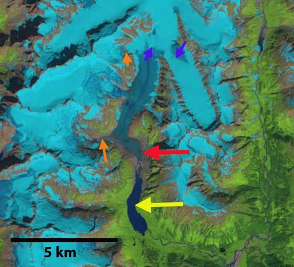
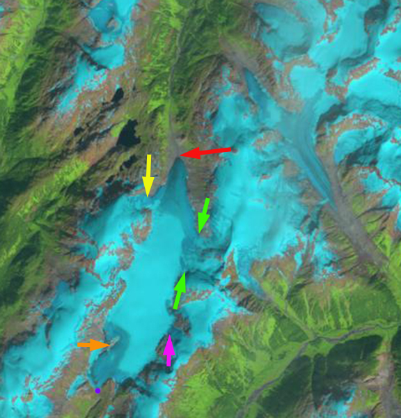
Chickamin Glacier, Alaska in 1985 and 2018 Landsat images indicating the 3.5 km retreat and associated lake expansion. Red arrow is 1985 terminus location, yellow arrow is the 2018 terminus location, pink arrow is former junction area with Through Glacier.  The purple dots indicate the snowline.  Point 1 and 2 are locations of bedrock expansion above the equilibrium line altitude. 

Chickamin Glacier in southeast Alaska glacier drains south from an icefield near Portland Canal and straddling the border with British Columbia. The glacier ended on an outwash plain in 1955 at an elevation of 250 meters.  Shortly thereafter a lake began to form, and by 1979 a Landsat image indicates a lake that is 1300 meters long and a retreat of ~2.5 km from 1902-1979 (Molnia, 2008). The glacier at that time was fed by a substantial tributary entering from the south ~5 km above the terminus, Through Glacier-pink arrow. Here we examine Landsat images from 1985-2018 to identify the response to climate change.

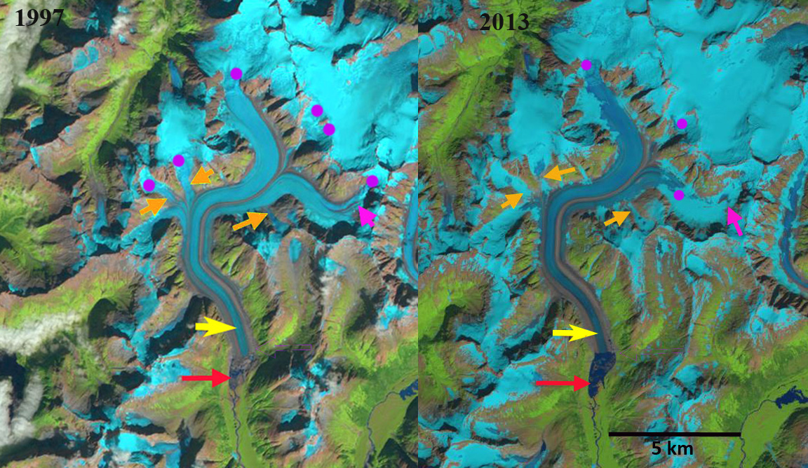
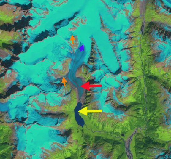
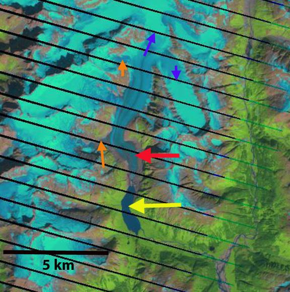
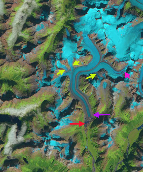
In 1985 the glacier terminated at an elbow in the lake where the lake both narrows temporarily and turns east, red arrow. The glacier had terminated close to this location for 30 years. The snowline is at 1150 m, and Through Glacier still connects to Chickamin Glacier.  At point 1 and 2 the area of exposed bedrock is limited. In 1994, the glacier has retreated 500 m from the elbow.  Through Glacier has separated from Chickamin Glacier. The snowline in 1994 is at 1125 m.  In 2013, Through Glacier has retreated 1600 m from Chickamin Glacier. Chickamin Glacier has retreated 2 km since 1985 and the snowline is at 1250 m.  By 2018 Chickamin Glacier has retreated 3.5 km since 1985 a rate of just over ~100 m/year, yellow arrow. The terminus is currently at a point where the lake narrows, which should reduce the retreat rate.  In 2018, the snowline reached 1525 m, leaving only 10-15% of the glacier in the accumulation zone.  The exceptionally high  snowline in 2018 was also noted at Taku Glacier. The snowline from 2014-2018 has persistently been above 1350 m, which indicates substantial negative mass balance for the glacier that will drive continued retreat. The persistent snowline elevation above 1250 m is indicated by the expansion of bedrock areas at Point 1 and 2 from 1985 to 2018, which both are located in what was the typical accumulation zone prior to that time.

The sustained mass balance losses follow that of Lemon Creek Glacier, which has a a long term record from 1953-2018 indicating a loss of  ~-0.5 m/year (Pelto et al. 2013).  The retreat and lake expansion has become a chorus with more than 20 coastal Alaskan glaciers having at least a 2 km lake expansion due to retreat since 1984, documented individually in previous posts at this blog.

Chickamin Glacier, Alaska in 1994 and 2013 Landsat images indicating the 3.5 retreat and associated lake expansion. Red arrow is 1985 terminus location, yellow arrow is the 2018 terminus location, pink arrow is former junction area with Through Glacier.  The purple dots indicate the snowline.  Point 1 and 2 are locations of bedrock expansion above the equilibrium line altitude. 

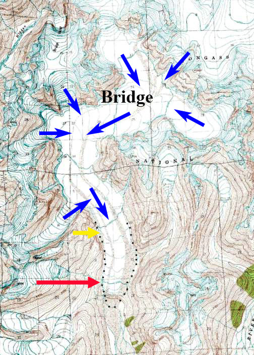
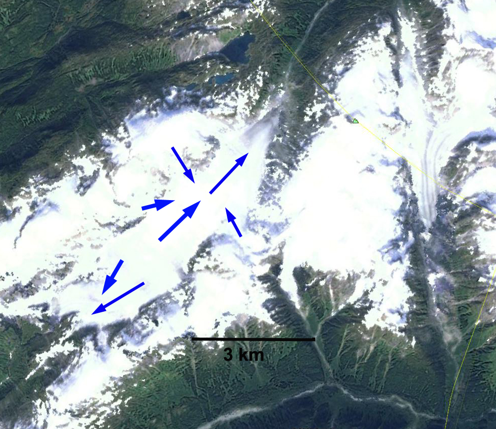
USGS map of Chickamin Glacier based on 1948 aerial photographs

Bridge Glacier, Southeast Alaska Retreat & Lake Formation

Bridge Glacier in Landsat image from 1984 and Sentinel image from 2017. The red arrow indicates the 1984 terminus where no lake exists, yellow arrow is 2017 terminus, orange arrows are selected tributaries and purple dots the snowline. 

Bridge Glacier drains the same icefield as the Wright and Speel Glacier 45 km southeast of Juneau, Alaska. Here we examine the changes in this glacier from 1984-2017 using Landsat and Sentinel imagery.

In 1984 the glacier ended on an outwash plain at the head of a branch of Speel River. The red arrow indicates the 1984 terminus for each image, the yellow arrow the 2017 terminus and the orange arrows three tributaries feeding the glacier.  The purple dots indicate the snowline at 1200 m. In 1984 all three tributary glaciers fed Bridge Glacier and the glacier has no proglacial lake at the terminus. In 1997 a lake basin is beginning to develop, though it is still largely filled by ice. The eastern tributary pink arrow, has lost all of its snowpack. The three tributaries at the orange arrows are connected to Bridge Glacier still and the snowline is at 1250 m. In 1999 the proglacial lake has formed and has length of 1 km, the lake has expanded south and north of the 1984 terminus position, and does not entirely represent glacier retreat.  In 2013 the glacier has retreated 1200 m from the 1984 position and the lake is still expanding. The orange arrows indicate that none of the three tributaries are still connected to the main glacier. The glacier in a sense is losing its income flow from these subsidiaries. The eastern tributary has retained some snowcover with six weeks left in the melt season in 2013, but this is mostly gone a month later, the snowline is at 1100 m. nbsp; Total retreat from 1984 to 2017 is 1900 m. In 2017 the snowline is at 1300 m, and the separation of the tributaries is by more than 500 m in each case. The snowline has been high by the end of each summer from 2014-2017 indicating retreat will continue. The retreat of this glacier is the same story as seen at nearby PattersonGilkey and Norris Glacier.

.

Bridge Glacier in Landsat images from 1997 and 2013. The red arrow indicates the 1984 terminus , yellow arrow is 2017 terminus, orange arrows are selected tributaries and purple dots the snowline. 

Bridge Glacier in USGS map when it ended on the outwash plain in 1948.


Sinclair Glacier Retreat, Alaska

Sinclair Mountain is on the east side of the Lynn Canal in southeast Alaska. The mountains hosts too substantial glacier, the south flowing unnamed glacier is referred to here as Sinclair Glacier. This glacier terminated in a lake in the 1982 map of the Skagway region. I observed this glacier from the air in 1982 and it was ending in this lake. Here we examine Landsat imagery from 1984 to 2014 to identify changes. sinclair map
USGS Skagway map
Sinclair ge
Google Earth Image

In 1984 the glacier ended at a prominent peninsula in the lake, red arrow in each image, the lake was 1700 m long. The snowline was at 950 m, indicated by the purple arrow, this was at the end of the melt season. The glacier was joined by two tributaries from the west side, orange arrows. In 1986 there is a small amount of terminus retreat visible. By 2001 the glacier has retreated out of the lake, which is 2.9 km long. By 2004 the southern tributary at the orange arrow is no longer connected to the glacier. The glacier has retreated 1.3 km from 1984-2004. The snowline is at 950 m with a month left in the melt season. In 2009 the image is not great quality, but the northern tributary is still connected to the main glacier by a thin tongue of ice at an icefall at 850 m. By 2013 the northern tributary is no longer connected to the main glacier, there is bare rock extending across the full width of the former icefall area. In 2014 the image is from the end of July and the snowline is already above 950 m. It is evident that the glacier will lose nearly all of its snowcover by the end of the melt season on October 10th. The glacier has retreated 900 meters since 2004, and 2.2 km since 1984. The recent loss of tributaries indicates less contribution of ice to the glacier and that retreat will continue. This retreat is the same as that of nearby Field Glacier, Meade Glacier and Ferebee Glacier.
sinclair 1984

1984 Landsat image
sinclair 1986
1986 Landsat image
sinclair 2001
2001 Landsat image
sinclair 2004
2004 Landsat image
sinclair 2009
2009 Landsat image
sinclair 2013
2013 Landsat image
sinclair 2014
2014 Landsat image

West Speel Glacier Retreat and Lake Formation, Southeast Alaska

West Speel Glacier is an unnamed glacier that drains the same icefield as the Wright and Speel Glacier 45 km southeast of Juneau, Alaska. Here we examine the changes in this glacier from 1984-2013 using Landsat imagery. west speel glacier ge
Google Earth image

In 1984 the glacier ended on an outwash plain at the head of a branch of Speel River. The red arrow indicates the 1984 terminus for each image, the purple arrow the 2013 terminus and the yellow arrows tributary glaciers. In 1984 all three tributary glaciers fed West Speel Glacier and the glacier has no proglacial lake at the terminus. The eastern tributary pink arrow has some retained snowpack with three weeks left in the melt season. Each tributary indicated by yellow arrow is still contributing to the glacier. In 1997 a lake basin is beginning to develop, though it is still largely filled by ice. The eastern tributary pink arrow, has lost all of its snowpack. In 1999 the proglacial lake has formed and has length of 1 km, the lake has expanded south and north of the 1984 terminus position, and does not entirely represent glacier retreat. The noted tributaries are still all connected to the main glacier. In 2013 the glacier has retreated 1200 m from the 1984 position and the lake is still expanding. The yellow arrows indicate that none of the three tributaries are still connected to the main glacier. The glacier in a sense is losing its income flow from these subsidiaries. The eastern tributary has retained some snowcover with six weeks left in the melt season in 2013, but this is mostly gone a month later. The melt season is off to a quick start in 2014, which promises to be a poor year for this glacier. The retreat of this glacier is the same story as seen at nearby Speel, Gilkey and Norris Glacier. west speel glacier 1984
1984 Landsat image
west speel glacier 1997
1997 Landsat image

west speel glacier 1999
1999 Landsat image

west speel glacier 2013
2013 Landsat image

west speel 2013sept
Sept. 2013 Satellite image

Gracey Creek Glacier Retreat and Tributary Loss, Alaska

Gracey Creek Glacier is a small glacier in southeast Alaska that terminates near the Canadian border. The glacier’s main terminus is the northern terminus (red arrow), though it has southern terminus as well (purple dot), both drain into Behm Canal via different rivers. Here we examine Landsat images from 1987 to 2013 to identify retreat and tributary separation in the last quarter century.
gracy creek map
USGS map of Gracey Creek Glacier

gracey creek
Google Earth image indicating direction of flow.

In 1987 Gracey Creek Glacier is fed by several main tributaries yellow, pink and light green arrows. The glacier’s northern terminus is at the red arrow and the southern terminus at the purple dot. By 1997 the pink tributary no longer connects to the main glacier, and the other tributary connections are much narrower. The glacier has retreated 200 m at the northern terminus and 50 m at the southern terminus. Snowcover is quite limited on the glacier. In 2010 the yellow tributary is no longer connected to the main glacier. The area of bedrock at the orange arrow near the southern terminus is greatly expanded. The northern terminus has retreated 400 m and the southern terminus 100 m. Of more importance in 2010 is the limited snowpack that is left, even though this is in mid-August with five weeks left in the melt season. By 2013 the only tributary connection is at the green arrows though this is only 40% of its 1987 width. The northern terminus has retreated 600 m since 1987 and the southern terminus 200 m.

There is limited snowpack in this late August image as was the case in the 1997 and 2009 image, this has become typical not unusual. The bad news is that in 2013 the melt season extended into mid-August and it is likely little snow remained on the glacier. The limited snowcover, loss of connection with higher elevation tributaries and thinning of the glacier even at its higher elevations indicates this glacier cannot survive current climate (Pelto, 2010). This thinning in the accumulation zone is evident from the reduction in width of the glacier at the divide between the southern and northern terminus, this is indicative of retreat of the lateral margins of the upper portion of the glacier, another sign of a glacier that cannot survive. The glacier is still 6.8 km long and it will not disappear quickly. The retreat here is less than on nearby Chickamin Glacier, Bromley Glacier and Nass Peak Glacier, however the changes on the upper glacier are the story. This glacier is similar in size and retreat to Lemon Creek Glacier of the Juneau Icefield.
gracey creek 1987
1987 Landsat image
gracey creek 1997
1997 Landsat image

Gracey Creek 2010
2010 Landsat image

gracey creek 2013
2013 Landsat image