Suiattle, White River, Whitechuck and Honeycomb Glaciers North Cascade Range Diminishing Rapidly

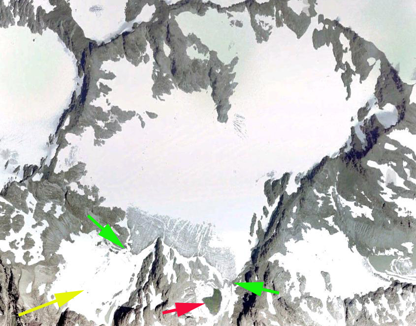
USGS Map of the four glacier from 1984, with none of the seven lakes existing.

In 1988 we mapped four glaciers arrayed around the Kololo Peaks just south of Glacier Peak; Honeycomb and White River feeding into Wenatchee Lake watershed, while Whitechuck and Suiatlle fed into the Suiattle River watershed. They had a combined area of 9.2 km². The glaciers had not developed a series of proglacial terminus lakes at that time. We visited each glacier and completed observations in 1995 and 2002 illustrated the formation of six proglacial lakes, with one more developing after that, Lake #7. Further details and image for Whitechuck Glacier . In 2022 the glaciers have retreated away from each of these lakes that had not even begun to form in 1988. The combined area of the four glaciers in 2022 is 5.6 km², a 40% decrease in 34 years.

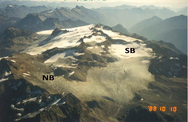
Whitechuck Glacier in 1988, with the North Branch and South Branch joined and terminating at Lake #5.

Whitechuck Glacier in 2002 with a detached glacier segment at Lake #5.

White River Glacier in 1988 with no lake yet formed at #3 or #4.

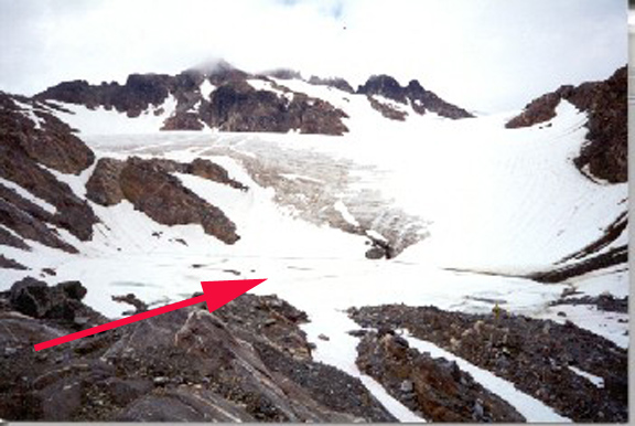
White River Glacier terminus with Lake #3 having formed, but still largely snowcovered in early August.

Honeycomb Glacier in 1995 with no lake #1 at the terminus yet.

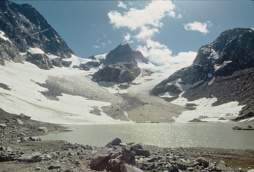
Honeycomb Glacier in 2002 still in contact with Lake #1.

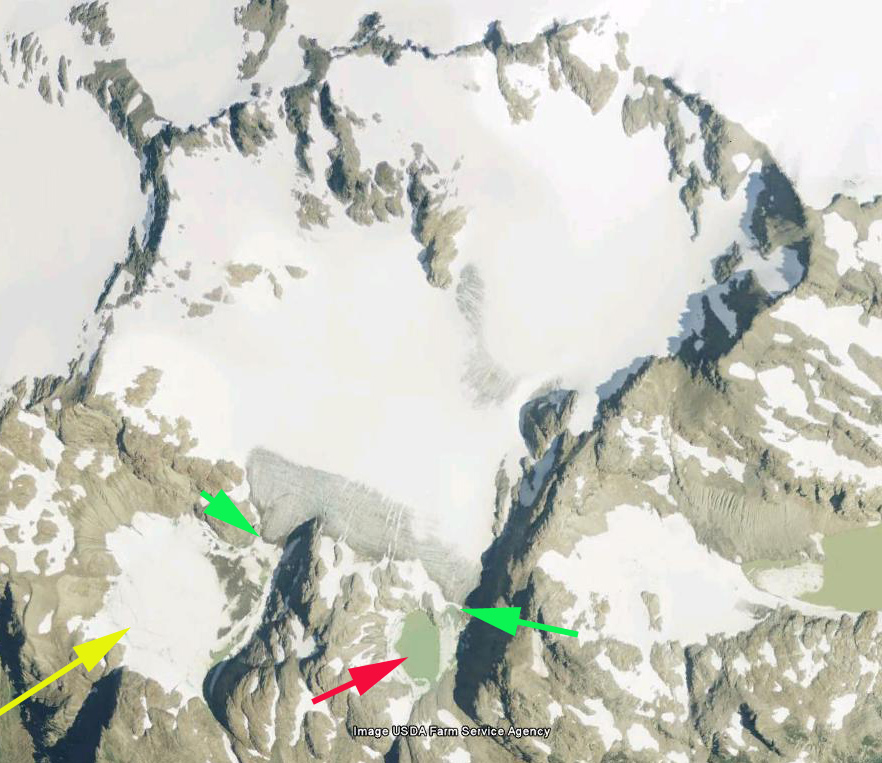
Kololo Peak glaciers in Sept. 9 2022 Sentinel image.  H=Honeycomb, S=Suiattle, WC=Whitechuck, WR=White River, purple dots are the snowline and Point 1-7 proglacial lakes that formed after 1988 and are no longer in constact with glacier.

In 2022 we had the most extensive melting we have observed after September 1, with active significant melt extending to October 19. The result is striking in Sentinel images from Sept. 7 and Oct. 19 indicating the reduction in snowcovered area, the percentage of a glacier covered by snow is its accumulation area ratio (AAR). On September 9 the AAR of these glaciers was 45% diminishing to 10% by October 19. With negligible retained snowpack on Whitechuck and White River Glacier. Since 1988 Honeycomb Glacier has retreated 950 m, White River Glacier 475 m, Whitechuck Glacier 950 m and Suiattle Glacier 450 m.

Kololo Peak glaciers in Oct. 19, 2022 Sentinel image.  H=Honeycomb, S=Suiattle, WC=Whitechuck, WR=White River, purple dots are the snowline and Point 1-7 proglacial lakes that formed after 1988 and are no longer in constact with glacier.

White River Glacier Disequilibrium Retreat, Washington

White River Glacier in the North Cascades of Washington is on the southeast flank of Glacier Peak. From 1955-1967 White River Glacier had a stable though thinning terminus. In 1967 the glacier descended from the summit area of Kololo Peak separating into two terminus tongues ending in two basins. In both basins the glacier terminus filled the basins and flowed a short distance beyond the basins. During my first visit to the glacier in 1988 there was the fringe of a new lake for both the northern and southern arm of the glacier at the yellow and red arrow respectively, with retreat of both termini into the basin, 60 m of retreat. The southern terminus is fed by an icefall green arrow.White River 67
1967 Image from Austin Post (USGS)

White River 88
1988 image

By 1995 when we returned the northern branch of the glacier, red arrow, had developed a lake that was 150 m across, and the terminus was in contact with the lake. The southern basin was still mostly ice filled, with 60 m of open water at the southeast corner. In 2002 we revisited the glacier the northern basin terminus had retreated 20 m from the lake. The southern basin was still filled with glacier ice, but this ice was now flat and floating in the water. There were numerous water filled cracks. The lake was 265 m across. By 2002 the terminus had retreated out of the southern lake basin ending at the base of the icefall slope. The lake is evident even with its floating glacier ice cover. In 2006 and 2009 Google Earth imagery the retreat of the southern terminus up the icefall slope is evident. In 2013 there is still floating glacier ice in the southern lake basin, image from Stefan Feller. The glacier retreat of the northern terminus from 1967-2013 has been 370 m, the southern terminus 450 m. The main issue for this glacier is that the upper part loses snowcover during many years. This means the glacier is having a disequilibrium response to climate and will not survive (Pelto and Hedlund, 2001). Thinning and retreat of the upper glacier indicates the lack of a persistent accumulation zone, hence the glacier cannot survive our greenhouse warmed climate, leaving mother nature less than pleased. Advertising Illustration A1
Mother Nature sketch from Megan Pelt-Savannah College of Art and Design

(Pelto, 2010). This glacier’s retreat paralells that of two adjacent glaciers Honeycomb and Whitechuck , but is greater than on adjacent Suiattle Glacier

White River Glacier 95
1995 view of northern terminus from 1967 terminus location

white river glacier 2002
2002 glacier view with southern terminus

white river 2006
2006 Google Earth image

white river2 2009
2009 Google Earth image

white river glacier 2013
2013 image from