Wright Glacier, Alaska Snowline and Terminus Retreat

Wright Glacier in 1984 and 2019 Landsat images.  The red arrow indicates 1984 terminus location, yellow arrow 2019 terminus location, pink arrow where the surface slope steepens and red dots indicate the snowline. 

Wright Glacier is the largest glacier draining an icefield just south of the Taku River and the larger Juneau Icefield. The glacier accumulation zone is mainly in British Columbia.  The glacier filled a lake basin in 1948 as illustrated by the USGS map and  NSIDC collection,  though the terminus is beginning to break up.

In 1984 the glacier ended at a peninsula in the lake where the lake turns east.  This was my view of this glacier during the summers of 1981-1984 from the Juneau Icefield with the Juneau Icefield Research Program. Our bad weather came from that direction so keeping an eye on that region during intervals between weather events was the practice. Here we examine Landsat imagery from 1984-2019 to document the retreat of Wright Glacier and the rise in elevation of the snowline.

In 1984 the lake had a length of 3.1 km extending northwest from the glacier terminus. The snowline in mid-August with a month left in the melt season was at 1150 m at a main glacier junction.  By 1993 the glacier had retreated little on the north side of the lake and 200 m on the south side. The snowline in mid-September close to the end of the melt season was at 1150 m. By 2013 the glacier had retreated 900 m and was terminating in a narrower portion of the expanding lake, 30 m/year. The snowline was again at the main junction near 1150 m. In 2018 the snowline on September 16th was at 1450 m with less than 25% of the glacier in the accumulation zone.  In 2019 on Aug. 2 the snowline was at 1500 m, likely the highest snowline in the last 70 years, as was the case at nearby Taku Glacier. The high snowlines of recent years has driven an acceleration of the retreat of 1000 m since 2013, 150+ m/year. The glacier has a steeper surface slope 2 km beyond the current terminus front indicating the lake ends either near this point, pink arrow.  This could lead to a reduction in the retreat rate, though calving has not been a major factor in retreat of this glacier.

The glacier drains the same icefield as the retreating West Speel and Speel Glacier.

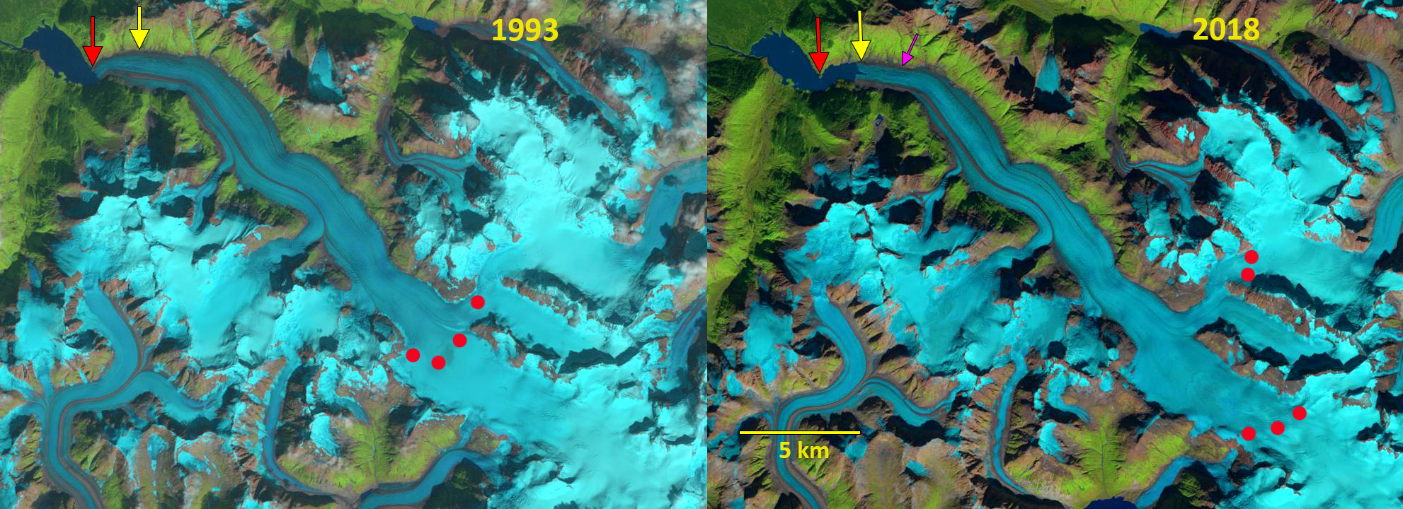
Wright Glacier in 1993 and 2018 Landsat images.  The red arrow indicates 1984 terminus location, yellow arrow 2019 terminus location, pink arrow where the surface slope steepens and red dots indicate the snowline.

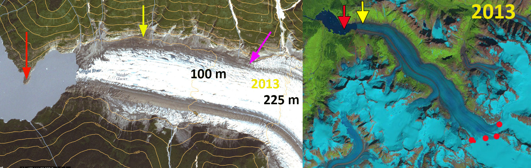
Wright Glacier in 2013 Landsat images and USGS Topo imagery.  The red arrow indicates 1984 terminus location, yellow arrow 2019 terminus location, pink arrow where the surface slope steepens and red dots indicate the snowline.

Wright Glacier Retreat, Southeast Alaska

Wright Glacier is the main glacier draining a small icefield just south of the Taku River and the larger Juneau Icefield. Wright Glacier is 60 km east of Juneau and has ended in a lake since 1948. A picture of the glacier in 1948 from the NSIDC collection indicates the terminus mainly filling the lake, but breaking up. The glacier drains the same icefield as the retreating West Speel and Speel Glacier. The dark blue arrows indicate the flow vectors of Wright Glacier, light blue arrows flow vectors for adjacent glaciers. Despite being 30 km long this glacier has been given very little attention, maybe because it does not reach tidewater.
wright glacier1948080301
NSIDC Glacier Photograph Collection Photographer unknown.

wright glacier ge
Google Earth view

In 1984 the glacier ended at a peninsula in the lake where the lake turns east. This was my view of this glacier during the summers of 1981-1984 from the Juneau Icefield with the Juneau Icefield Research Program. Our bad weather came from that direction so keeping an eye on that region during intervals between whiteout weather events, the norm, was prudent. Here we examine Landsat imagery from 1984-2013 to document the retreat of Wright Glacier and the elevation of the snowline on the glacier. The red arrow indicates the 2013 terminus, the red arrow the terminus at the time of the image and the red dots the snowline on the date of the imagery. In 1984 the lake had a length of 3.1 km extending northwest from the glacier terminus. The snowline in mid-August with a month left in the melt season was at 1150 m. By 1993 the glacier had retreated little on the north side of the lake and 200 m on the south side. The snowline in mid-September close to the end of the melt season was at 1150 m. In 1997 the fourth in a five year run of extensive mass balance losses and high equilibrium lines in the region, noted on the Juneau Icefield (Pelto et al, 2013), the snowline had risen to 1450 m. The terminus had retreated 200 m on the north side since 1984 and 600 m on the south side. In 2003 the snowline was at 1250 m with a month left in the melt season. The terminus retreat on the north side and south side since 1984 had now evened out with 900 m of retreat. In 2013 the snowline was at 1150 m in mid-August and 1350 m by the end of the melt season. The terminus had retreated 1300 m since 1984 and the lake is now 4.5 km long. The lower 2 km of the glacier has many stagnation features on it, suggesting continue retreat. It is unclear how far the basin that will be filled by the lake upon retreat extends, but it is not more than 2 km from the current terminus, as a small icefall reflecting a bedrock step occurs there. This glaciers retreat has accelerated since 1984. To be in equilibrium the glacier needs a minimum of 60% of its area to above the snowline at the end of the melt season. This is to offset the 10-12 m of melt that occurs at the terminus. This requires a snowline no higher than 1150 m. The snowline has been above this level in 1994-1998, 2003-2006 2009-2011 and in 2013, which suggest the glacier cannot maintain its current size and will continue to retreat. The glacier has a larger high elevation than the West Speel and Speel Glacier that originate from the same mountains. The glacier is following the pattern of retreat of all but one of the glaciers of the Juneau Icefield.

wright glacier 1984
1984 Landsat image

wright glacier 1993
1993 Landsat image

wright glacier 1997
1997 Landsat image

wright glacier 2003
2003 Landsat image

wright glacier 2013
2013 Landsat image