Reru Glacier, Kashmir Retreat and Lake Expansion

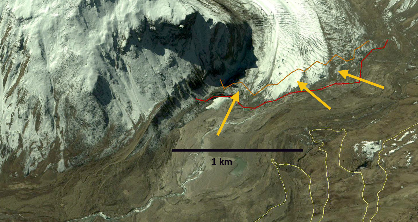
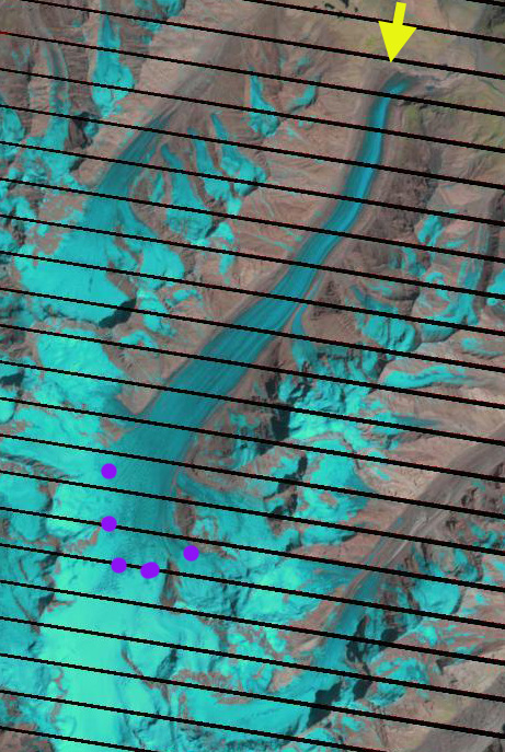
Reru Glacier in 1998 and 2018 Landsat images.  The red arrow indicates the 1998 terminus location, the pink arrow a recent landslide, Point 1 and 2 are tributaries that are losing connection with the main glacier and purple dots are the snowline.

Reru Glacier, Kashmir is at the headwaters of the Reru River, which drains into the Doda River and then the Zanskar River.  Murtaza et al (2017) noted a 17% loss in glacier area and a 80-300 m rise in the ELA of Kashimir glaciers form 1980-2013. This is similar to the rate of loss from 1962-2001 of 18% reported by Rai et al (2013) The Kolahoi Glacier has experienced an accelerated retreat in the last decade (Rashid et al, 2017)Babu Govindha Raj (2010) identified  the glacier retreating at an average rate of 12 m per year from 1975-2005,  with lake area expanding from 0.17  to 0.42 square kilometers.  Here we examine Landsat images from 1998-2018 to document changes of Reru Glacier.

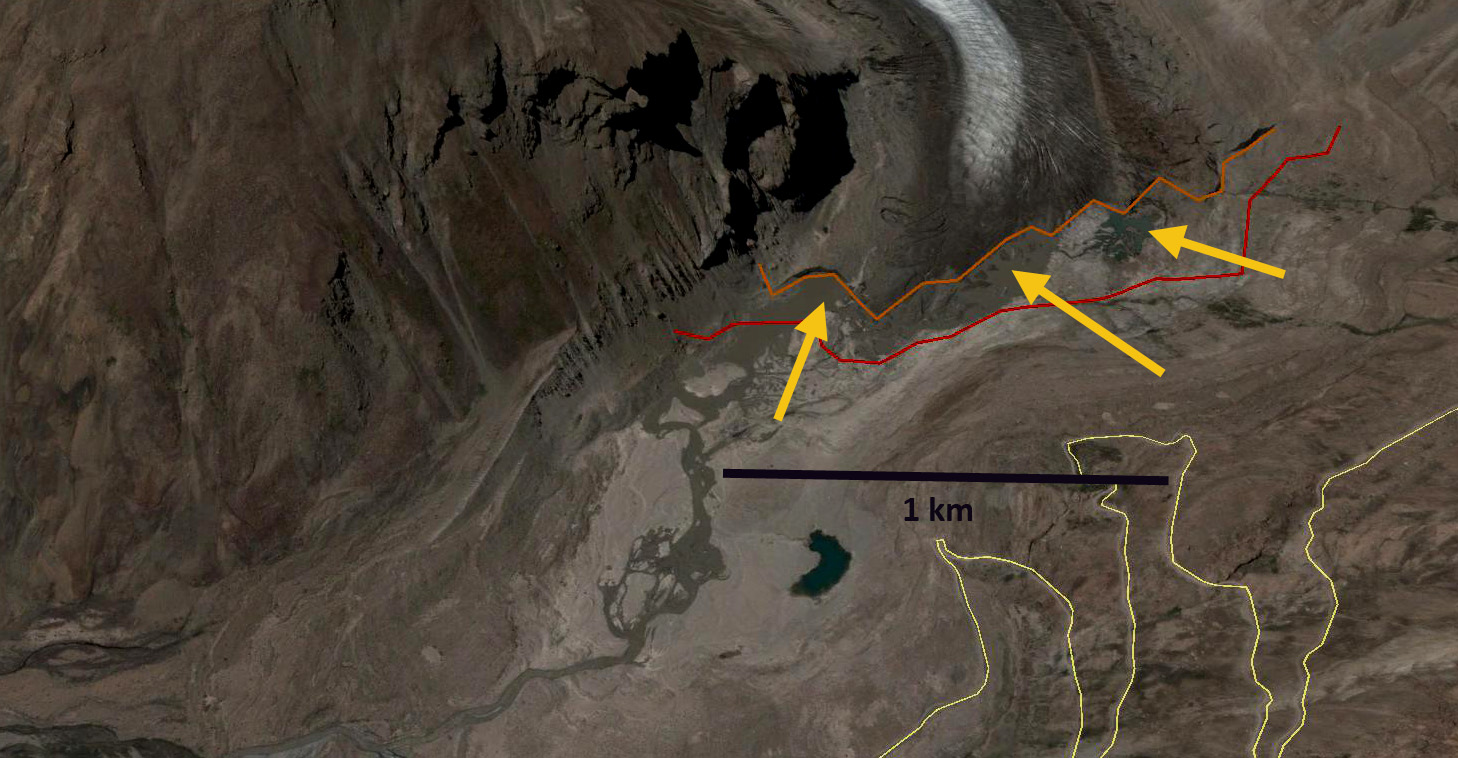
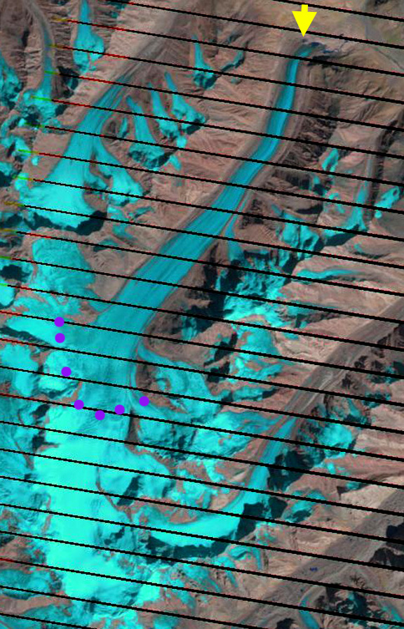
In 1998 the glacier terminates in a 1 km long lake. The snowline is at 500 m, and tributaries at Point 1 and 2 flow into the main glacier. In 2002 the snowline is at 5300 m, the tributaries still join the main glacier and no landslide is evident at the pink arrow.  By 2014 the glacier terminates in the proglacial lake that has expanded to 1.6 km in length and tributary 1 has detached from the main glacier.  The snowline is at 5100 m.  In 2018 the glacier has retreated from the proglacial lake which is 1.7 km long.  The glacier has retreated 600-700 m since 1998.  A landslide is now evident at the pink arrow. Potentially from the period of intense flooding in 2015. Tributary #2 has a narrow but existing connection to the main glacier. The snowline in 2018 is particularly high at 5700 m. This is reflective of the high freezing levels in this area in 2018.  The retreat is significant, but not rapid.  This is similar to both Kolahoi Glacier and Durung Drung Glacier.

Reru Glacier in 2002 and 20184 Landsat images.  The red arrow indicates the 1998 terminus location, the pink arrow a recent landslide, Point 1 and 2 are tributaries that are losing connection with the main glacier and purple dots are the snowline.

Durung Drung Glacier Retreat, Zanskar, India

The Durung Drung Glacier (Drang Drung) is a frequently seen glacier from the unpaved Kargil-Leh road in the Zanskar, Lakdakh region of India that flows north from the slopes of Doda Peak. This road climbs up the Suru River valley from Kargil, crosses Pensi La Pass crosses the front of the Durung Drung Glacier and descends the Zanskar River valley to Nimoo. The Zanskar River joins the Indus River just above the village of Nimoo. The Nimoo Bazgo Hydroelectric Project opened in 2012 and provides 45 MW of power to the Ladakh Region. Chris Rubey has a nice image of this power plant. This is a run of river project, that does not alter the downstream flow, but it does have a reservoir that stores 120,000,000 gallons of water, as seen in a 2013 Landsat image.

durung drung 1998a
1998 Landsat Image show flowlines fro Durung Drung Glacier

nimoo Bagzo 2013
2013 Landsat image of the dam and reservoir for the Nimoo Bagzo Hydropower Project

There have a few inaccurate reports of late that this glacier is not currently retreating. Here we examine Landsat and Google Earth imagery from 1998 to 2013 to identify the magnitude of the recent retreat. In Landsat images in 1998 there were no evident proglacial lake at the terminus of the glacier, red arrow. By 2013 a series of proglacial lakes are evident in Landsat images at the terminus red arrow. Looking at the higher resolution Google Earth imagery from 2004 and 2013. The retreat and development of the lakes is apparent. In each image the red line is the 2004 terminus and the brown line the 2013 image, orange arrows indicate three lakes that have formed by 2013. The retreat is 200-250 m not large for a glacier of this size but significant for such a short period of time. More importantly the smooth low slope terminus with pieces breaking off into the proglacial lake in 2013 is indicative of a glacier that is thinning and retreating, note video. The lowest 1.2 km of the glacier is uncrevassed and has a low slope suggesting this area will continue to melt away. An image from a Zanskar River expedition indicates the lakes and icebergs in the lakes as well with the blue arrows indicating the low-sloped uncrevassed region. durung drung 1998
1998 Landsat of Durung Drung Glacier terminus

durung Drung close 2013
2013 Landsat of Durung Drung Glacier terminus

durung drung glacier terminus 2004
2004 Google Earth image of Durung Drung Terminus

durung drung terminus 2013
2013 Google Earth image of Durung Drung Terminus

durung drung glacier exped
Whitewater Asia image

Landsat images from 2005 and 2013 indicate the snowline on the glacier as well as the change at the terminus. In 2005 and 2013 the snowline is at 5100 m, purple dots. Given that the glacier extends from 6000 m to 4100 m this is near the median elevation, but this is also likely not the date of highest snowline position. The retreat of Durung Drung Glacier is similar to the more debris covered Gangotri Glacier and Satopanth Glacier but slower than the similarly debris limited Malana Glacier and Samudra Tupa Glacier

durung drung 2005
2005 Landsat image

durung Drung 2013
2013 Landsat image