
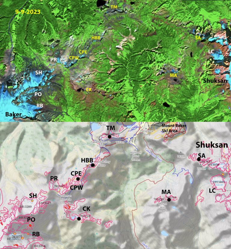
Glaciers on the ridge from Moutn Shuksan to Mount Baker that we observed to be active in mid 1980s, identified in GLIMS map below. Above Sentinel image from 9-9-2023. Glaciers that are no longer glaciers in yellow, seven of them including Mount Ann=MA, Shuksan Arm=SA, Coleman Pinnacle East/West=CPW/CPE, Camp Kiser=CK, Table Mountain=TM and HBB=Happy Bunny Butte. We still monitor each year Lower Curtis, Rainbow and Sholes.
The two most prominent mountains of the North Cascades Mount Shuksan and Mount Baker are connected by a ridge from Shuksan Arm to Ptarmigan Ridge. We visited 12 glaciers along and close to this ridge in the mid-1980s, to decide which to monitor annually. At that time each of these had active crevasses and significant area of glacier ice. We By the end of 2023 seven of the twelve glaciers are gone. We continue to monitor Lower Curtis, Rainbow and Sholes Glacier in detail. Portals and Ptarmigan Ridge Glacier which we visit every year, but do not assess in detail, will likely disappear in the next few years. Below is the evolving area and the date the glacier was lost, the area reported in the 1958/84 period and 2015 are from GLIMS and the 2023 area we determined from Sentinel imagery.
| Glacier | GLIMS ID | Year Lost | 1958/84 Area | 2015 Area | 2023 Area |
| Camp Kiser | G238275E48809N | 1993 | 0.22 | 0.03 | 0 |
| Happy Bunny Butte | G238277E48834N | 2005 | 0.166 | 0 | 0 |
| Table Mountain | G238295E48850N | 2015 | 0.158 | 0 | 0.008 |
| Coleman Pinnacle | G238269E48826N | 2018 | 0.56 | 0.031 | 0.018 |
| Mount Ann | G238341E48818N | 2022 | 0.12 | 0.07 | 0.01 |
| Shuksan Arm | G238362E48838N | 2023 | 0.16 | 0.07 | 0.03 |

1963 image of Ptarmigan Ridge sent to me by Austin Post.

Ptarmigan Ridge glaciers in 1993-all small but still all nearly joined.

In 2024 the lack of glacier ice or perennial snow along Ptarmigan Ridge is evident.
