
Warren Glacier in Garibaldi Provincial Park, British Columbia, Canada terminus retreat has been observed for over a century.  A period of extensive retreat from 1890-1964 was followed by a period of minor advance from 1973-1977, and then rapid retreat from 1977-2009. Johannes Koch has documented this retreat in the map below and with the historic images as well, the work has been published with less colorful graphics (Koch et al., 2009).
 . When I first saw the glacier in 1986 it had just retreated from the edge of the lake. By 2003 as seen in the somewhat blurry satellite image below, the glacier was 310 meters from the lake edge. In the 2009 Google Earth image the glacier is 500 meters from the lake edge. The rate of retreat over the 25 year period is 20 meters per year. The rate of retreat has again increased from 2003-2009, being 32 meters/year.
 The upper section of the glacier has unlike nearby Helm Glacier maintained some snow covered areas even in poor snow summers such as 2005 and 2009. This suggests the glacier can survive current climate with further retreat. The average thinning of Warren Glacier is similar to that of Helm, Sphinx and Sentinel Glacier at nearly 50 meters since 1928, note Figure 14 (Koch et al. 2009). This thinning due to ongoing negative mass balance has led to a 50% reduction in area since 1928. The large area loss as a percentage reflects the large relatively flat low lying basin now occupied by the lake.
Author: mspelto
Professor of Environmental Science at Nichols College in Massachusetts since 1989. Glaciologist directing the North Cascade Glacier Climate Project since 1984. This project monitors the mass balance and behavior of more glaciers than any other in North America
Presena Glacier Italy, Needs a Blanket
The Presena Ski Resort in Italy utilizes the Presena Glacier for its upper lifts and to extend its season. The warm summer of 2012 has been hard on this glacier.  In 2008 this resort followed the example of Stubai, Austria and Les Arcs, France in utilizing an insulating blanket to reduce melting. Presena Glacier has lost a third of its volume since 1993. This led to adoption of wrapping the glacier in a 4 mm thick blanket of polypropylene matieral that in a test at the area reduced melt by 60%. The insulated blanket is apparent particularly along the lift in the image below. In 2012 the areas that were not protected by the blanket or groomed preferentially are evident as bare glacier ice.
 The insulating blanket is supposed to cover 90,000 square meters. The plan is to leave the blanket in place through the summer until mid-September. The entire glacier lost its snowcover in 2003 and 2005. The lower section of the glacier has separated into several thin sections that are rapidly melting away. In the photograph below the three separate terminus areas that are nearly completely detached from the upper glacier are noted with a T. The Lift (L) goes up the center of the upper glacier this area has lost its snowpack frequently as well by summer’s end in recent years. The Presena Glacier is responding to the warming climate in the same way as other Italian glaciers Forni Glacier and Dosde Glacier, and as the Italian Glacier Committee has noted observing that of glaciers observed in Italy in 2009 95 of the 111 glacier observed are retreating, 11 stationary and two advancing. The mass balance of Italian Glaciers in 2010 was again negative due to the high summer temperatures.


Murchison Glacier Retreat Increasing
Murchison Glacier drains southeast from the Mount Cook region, one valley east of Tasman Glacier. The end of the glacier terminates in a lake that is rapidly developing as the glacier retreats.  This retreat will become rapid as 2010 imagery indicates other proglacial lakes have now developed 3.5 km above the actual terminus. These lakes are at a higher elevation and may not endure but do help increase ablation, and in the image below show a glacier that is too narrow to provide flow to the lower 3.5 km. The increased retreat has been forecast by the NIWAand Dykes et al (2009)
  This lower section is debris covered, stagnant, relatively flat and will not survive long. The demise of the lower section of this glacier will parallel that of Tasman Glacier. The glacier has retreated 2200 meters from the moraines at the south end of the lake. There was not a lake in the 1972 map of the region. A comparison of 2006 and 2010 imagery indicates the decrease in glaciated area in the lake basin. The bottom image is from NASA after the Feb. 2011 earthquake near Christchurch that led to a major calving event of a portion of the rotten stagnant terminus reach of the Tasman Glacier. There is no evident calving event from Murchison Glacier. The lake on the western margin of the valley, separated from the main lake has since April 2010 expanded notably

 .
.  The glacier still has a significant accumulation area above 1650 m to survive at a smaller size. The lower debris covered tongue is 6 km long and extends from the terminus at 1050 meters to 1200 meters, a very low gradient to supply healthy flow from the accumulation area. The ongoing retreat is triggered by warming and a rise in the snowline in the New Zealand Alps observed by the NIWA
 .
.
Mittivakkat Glacier Retreat, Greenland
A paper by Mernild and others (2011) focusses on the Mittivakkat Glacier on the east coast of Greenland. The glacier is separate from the Greenland Ice Sheet and its climate response as a result more rapid and more similar to other alpine glaciers. Mernild and others (2011) observe that the glacier has retreated 1300 meters since 1931 and that it has had a considerable negative mass balance since 1995. Sebastian Mernild at the Climate, Ocean, and Sea Ice Modeling Group, Computational Physics and Methods, Los Alamos National Laboratory, Los Alamos, New Mexico has provided the pictures that document the terminus change. The field observations is completed in conjunction with Aarhus University and University of Copenhagen, both in Denmark. Notice the glacier ends just short of the coastline in 1931, but in 2006 is 1500 meters from the coastline. 
 Mittivakkat Glacier has a mass balance record since 1995, that is reported to the World Glacier Monitoring Service. During the 1995-2010 period the glacier’s average balance has been -0.87 meters/year. The cumulative loss is -13 m, with the highest loss being in 2010 at -2.16 m. The 13 m loss in water equivalent snow-ice is equivalent to more than 14 m of ice thickness and 15% of the glaciers entire volume. The problem for the glacier is the loss of essentially all of its snow cover in four of the last ten years, this is not a recipe for long term glacier survival (Pelto, 2010). The image immediately below is a Digital Globe image from July 2005 indicating the snow covered area with six weeks left in the melt season is already limited, the glacier is in the center of the image and is the largest ice mass by far. The middle image from 2006 has areas of firn exposed indicated with blue arrows, this is not the end of the melt season yet. The lower image is from August 26 2010 and is a MODIS image catalogued by the Danish Meteorological Institute.The arrow indicates the glacier which has only 10% snow covered area, with a couple of weeks of melting left in the season.

 In 2010 air temperatures at Tasiilaq a few kilometers from the glacier were in the range of 1.5 C above average leading to twice the normal melt rate at the terminus, which will generate an even more rapid retreat for 2010 and 2011. The high temperatures in 2010 were not limited to this location as noted by Jason Box of Ohio State. The high melt rates were as a result not limited to the Mittivakkat Glacier as observed by the record melting reported in the Arctic Report Card. The recent large negative balances will generate ongoing retreat. Mernild observes that in 2011 the mass balance was even larger than -2.45 m An image provided by Sebastian Mernild indicates a whole in the glacier near the terminus, indicating rapid retreat in the near future.
Redoubt Glacier Retreat, Washington
Redoubt Glacier, Washington is the northern most large glacier in the North Cascades. It drains into Depot Creek which flow north into British Columbia. The glacier began advancing in the 1950’s reaching the edge of steep cliff and in three locations spilling down this cliff. At the time of my first visit in 1984 the glacier was still advancing, 2 meters during that year. By 1988 it had begun to retreat, 22 meters total, as all North Cascades were by 1990. The glacier as shown in USGS maps based on aerial photographs, illustrates the margin of the glacier in 1978, this glacier margin is outlined in dark green and is apparent in the several Google Earth images used below. By 1984 photographs by Dale Kalamasz, though I was there, his photographs are much better, illustrate the extent of the glacier. 


 From 1984 to 2009 the glacier has retreated 100-400 meters along its front, with an average of 230 m. Given the main glacier (above) averages 1.5 km from top to bottom this is a significant portion of the glacier. There are no longer ice tongues spilling down the cliffs at the terminus. The western section (below) of the glacier has lost the greatest area, as the retreat is comparable but the glacier length is closer to a kilometer.
 If you looked up at the glacier from the small lake below the center of the margin, “Ouzel lake”, picture above the green line indicates the 1984 margin and the retreat since. It is typical for broad glaciers like the Redoubt to have less terminus retreat. The terminus change is evident in another view, the two lower images of the glacier from the 2009 Google Earth view and a photograph from 2009.


Lednik “Fytnargin” Retreat, Caucasus Range
Most alpine glaciers in the world remain unnamed, many of these are small, but some are just remote. Their story is no different from the named glaciers. An example is the glacier that drains the north side of Gora Fytnargin (4123 m). I will designate this Lednik “Fytnargin” for the purposes of this discussion. This glacier drains north from the boundary of Georgia and North Ossettia, Russia. The terminus is at 2460 meters, the top at 4100 meters and the snowline at 3200 m.  Google Earth provides two excellent views of the lower glacier from September 2006 (top image below) and September, 2009 (bottom image). In this three year interval the terminus of the glacier has retreated 450 meters. In 2006 a debris stagnant terminus area exists, that entirely melted away in three years.
 . The retreat of this glacier follows the pattern of glaciers in the region that are monitored. Stokes et al (2007) used satellite imagery to observe 113 glaciers in the region from 1980-2000 and found 95% to have retreated. They observed that the rate of retreat had increased and that a number of new lakes had formed due to the retreat. Lednik Fytnargin’s terminus has a low slope and limited crevassing and has numerous supraglacial stream channels. The combination of these indicates rapid retreat will continue in the near future. The terminus was located at 2380 m in 2006 and 2460 m in 2009
Grand Plateau Glacier Retreat, Alaska
Grand Plateau Glacier drains southwest from Mount Fairweather in southeast Alaska. The glacier advanced during the Little Ice age to the Alaskan coastline. Early maps from 1908 show no lake at the terminus of the glacier. The 1948 map shows three small distinct lakes at the terminus of the main glacier and a just developing lake at the terminus of the southern distributary terminus (D). By 1966 the glacier had retreated enough for the formation of one lake. The distance from the Nunatak N to the terminus was 12 km in 1948. The lake at D is 400 m wide.

USGS map displayed in Google Earth-1948 base images.
Landsat images from 1984, a Google Earth Mosaic of the 2003-2009 period and a Landsat image from 2013 indicate the substantial changes that have occurred. Here both the main terminus and a distributary (D) terminus draining south are examined. The main reference points in each image are the Nunatak, N, and and Island, I. The retreat from 1984-2013 is evident with the yellow arrows indicating the 1984 terminus and pink arrows showing the 2013 terminus location. The distance from the Nunatak to the terminus is 9.6 km in 1984, 6.8 km in the Google Earth image and 3.5 km in 2013. A six kilometer retreat at the glacier center in 30 years. On the north shore of the lake the retreat between arrows is 2.7 km from 1984-2013. From the island the glacier retreated 3.3 km from 1984-2013. The distributary tongue (D) retreated 2.2 km from 1984-2013. The offset of the terminus is 300-350 m indicating a five year retreat rate of 75-90 meters per year. The retreat has been driven by higher snowlines in recent years, the snowline had been reported at 3400 feet in the 1950’s. Satellite imagery of the last decade indicates snowlines averaging 1500 m, red arrows. The glacier snowline is evident in Landsat imagery in 2009 and 2013 red arrows. The combination of higher snowlines and increased calving into the terminus lake will continue to lead to retreat of this still mighty river of ice. This retreat parallels that of nearby Yakutat Glacier, Norris Glacier and Melbern Glacier

1984 Landsat image

2013 Landsat image

Google Earth images
Tungnaarjökull Retreat, Iceland
Tungnaarjökull drains the west side of the Vatnojökull Icecap. The glacier begins just west of the Grimsvotn Volcano at 1500 m. Just to the north of this large outlet glacier, 350 square kilometers, is the Loki Volcano. The first image below denotes these volcanoes and the epicenter of recent earthquakes. The volcanic activity is recorded in the dark ash layers that fall on the glacier in the accumulation area and are subsequently buried to emerge in the ablation zone. The snowline is visible in the imagery just above the highest ash horizon. The glacier drains into the Skaftá River which experiences jökulhlaups such as in June 2015.A June 6, 2015 Landsat image indicates little ablation being generated in the area.

June 6, 2015 Landsat Image

Google Earth Images
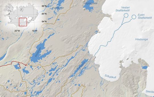
Iceland Met Service map of Skaftá River and jökulhlaup source.
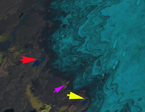
The glacier terminates at 800 m, and has a snowline since 2000 averaging 1300 m. Like many of the glaciers draining the Vatnajökull the glacier experiences periodic surges. Surging is a short term, several months to several years, acceleration and the associated advance of a glacier that is not primarily dictated by changes in mass balance or climate. A surge is related to a change in the basal water pressure that in this region is related to volcanic activity. The glacier surged in 1920, 1945 and 1995, that latter surge led to an advance of 1175 m in 1995. From 1955-1970 the glacier retreated at a rate of 75 m/year. From 1973-1992 the glacier retreated 1400 m. The surge led to an advance of 1175 m in 1995 bringing the glacier back close to its 1973 position. Since then the glacier has continued to retreat. Tungnaarjökull terminus is surveyed each year and the data reported to the WGMS. From 1996-2000 the glacier retreated 80 m. From 2001-2010 the glacier retreated 640 m. Below is the margin of the glacier indicating the moraine from which the glacier receded after the 1945 surge, the 1995 surge did not emplace a moraine. A comparison of Landsat images from 1999 and 2014 illustrates the retreat. Note the expansion of the lakes and the formation of a new one at the red and yellow arrow. The exposure of new moraine ridges at the purple arrow also indicates retreat.

1999 Landsat image
2015 Landsat image
The mass balance of this glacier has also been measured since 2000. During that period the glacier has had a negative balance every year, 12 of the 13 years the mass balance loss has been larger than 0.8 meter of water equivalent. The total loss for the period of 15 m, will lead to continued retreat. This is a substantial thinning of the glacier, but a small part of the total volume given a glacier that averages more than 500 m in thickness. The equilibrium line has been high since 2000, leading to only 40% of the glacier being snow covered at the end of the summer. on a glacier like this that lacks avalanche accumulation due to its low and consistent slope at least 60% of the glacier must be snow covered to have an equilibrium balance this would be 1150 m. This height is close to the elevation midpoint of the glacier.
Beyond the terminus the retreat is exposing a large relatively flat plain that is rich with glacial geologic deposits, many linear examples are evident. These features are streamline features from glacier flow. The retreat here is similar to the Bruarjokull on the north side and Skeidararjokulli on the west side of the Vatnojokull. 
Tungnaarjökull Retreat, Icleand
Tungnaarjökull drains the west side of the Vatnojökull Icecap. The glacier begins just west of the Grimsvotn Volcano at 1500 m. Just to the north of this large outlet glacier, 350 square kilometers, is the Loki Volcano. The first image below denotes these volcanoes and the epicenter of recent earthquakes. The volcanic activity is recorded in the dark ash layers that fall on the glacier in the accumulation area and are subsequently buried to emerge in the ablation zone. The snowline is visible in the imagery just above the highest ash horizon. The glacier terminates at 800 m, and has a snowline since 2000 averaging 1300 m. Like many of the glaciers draining the Vatnajökull the glacier experiences periodic surges. Surging is a short term, several months to several years, acceleration and the associated advance of a glacier that is not primarily dictated by changes in mass balance or climate. A surge is related to a change in the basal water pressure that in this region is related to volcanic activity. The glacier surged in 1920, 1945 and 1995, that latter surge led to an advance of 1175 m in 1995. From 1955-1970 the glacier retreated at a rate of 75 m/year. From 1973-1992 the glacier retreated 1400 m. The surge led to an advance of 1175 m in 1995 bringing the glacier back close to its 1973 position. Since then the glacier has continued to retreat. Tungnaarjökull terminus is surveyed each year and the data reported to the WGMS. From 1996-2000 the glacier retreated 80 m. From 2001-2005 the glacier retreated 240 m. Below is the margin of the glacier indicating the moraine from which the glacier receded after the 1945 surge, the 1995 surge did not emplace a moraine. The distance appears small, but averages 1.5 kilometers. This gives a sense of the scale of the glacier.
  The mass balance of this glacier has also been measured since 2000. During that period the glacier has had a negative balance every year, 8 of the nine years the mass balance exceeding 1 meter of water equivalent loss. The total loss for the period of 12 m, will lead to continued retreat. This is a substantial thinning of the glacier, but a small part of the total volume given a glacier that averages more than 500 m in thickness. The equilibrium line has been high since 2000, leading to only 40% of the glacier being snow covered at the end of the summer. on a glacier like this that lacks avalanche accumulation due to its low and consistent slope at least 60% of the glacier must be snow covered to have an equilibrium balance this would be 1150 m. This height is close to the elevation midpoint of the glacier. Beyond the terminus the retreat is exposing a large relatively flat plain that is rich with glacial geologic deposits, many linear examples are evident. These features are streamline features from glacier flow. The retreat here is similar to the Bruarjokull on the north side and Skeidararjokulli on the west side of the Vatnojokull.
Retreat of Glacier d’Argentiere, France
Glacier d’Argentiere flows 9 km northwest towards the valley of Chamonix, France just north of Mont Blanc and one valley north of the Mer de Glace. The glacier retreated 1000 meters from 1870-1967. The first picture below provided by Richard Hodgkins to the PAGES project shows a century of change. Below that is the 2009 terminus view in Google Earth. The terminus is quite crevassed indicating considerable velocity. It is currently at the top of a steep slope that it has retreated up in the last five years. 
 From 1968-1985 the glacier advanced 300 m. Since 1985 the glacier has been retreating at an increasing rate: 80 meters from 1991-1995, 187 meters from 1996-2000, 199 meters from 2001-2005, data is not in for the 2006-2010 period but the retreat is in excess of 200 meters. The retreat has been triggered by sustained negative mass balance. A mass balance program on d’Argentiere was begun in 2004, the glacier lost 1.3 m in 2004, 1.9 m in 2005, 1.4 m in 2006, 0.7 m in 2007, 1.3 m in 2008 and 2.6 in 2009. That is a cumulative mass balance loss of 9.2 meters of water equivalent lost from the glacier in six years, and that is a 10-11 m loss in average ice thickness from the glacier. The recent rapid retreat and mass balances losses parallel those of the other glaciers in the Alps from which data is reported to the WGMS. The reason for the mass balance loss is evident from the Google Earth imagery of August, 2009. The snowline, shown in lime green, is at 3300 meters on south facing slopes and at 2900 meters on north facing slopes and the main valley of the glacier, this is one month left in the melt season. At this point the glacier is 35-40% snowcovered and will be less by the end of the melt season.
  To be in equilibrium a glacier must have 60% snowcover at the end of the summer. From 2004-2009 the average snowcovered area at the end of the melt season was 30%. The tributary glaciers draining the south facing slopes of the valley have lost all their snowcover in 2005, 2006 and 2009. This is leading to a diminished contribution to the mainstem of the Argentiere.
  This will foster continued retreat. A view across the glacier in August 2008 from Jürg Alean indicates the meager snowcover on the south facing glaciers and the main glacier tongue.
Imja Glacier Retreat and Imja Tsho Lake expansion, Nepal
The Imja Glacier is in the Khumbu Range of Eastern Nepal’s Himalaya, just
southeast of Mount Everest. The glacier drains the east slopes of Lhotse, south slope of Penghatse and west slopes of Baruntse before flowing past the southern slope of Island Peak to terminate at Imja Tsho glacial lake. Imja Tsho formed after 1960 due to glacier retreat and is continuing to expand today.
 According to Fujita and others (2009), the lake in 2008 is 1.1 kilometers long and has an area of 0.9 km2 and a volume of 37 million cubic meters. Bajracharya and Mool (2009) observed that Imja Glacier itself retreated at a rate of 41 meters/year from 1961-2000 and 74 meters/year from 2001-2006. The terminus ends in the expanding lake and is heavily debris covered.
  A study by ICIMOD (The International Centre for Integrated Mountain Development, 2008) documented that all 22 glaciers observed in the Dudh Khosi Basin have retreated since 1976 with the minimum retreat being 10 meters/year and the maximum 59 meters/year
The Imja Glaciers is two valleys east of the more famous Khumbu Glacier which has been retreating at a slower rate of 15-20 meters/year. Imja Glacier like its neighbors can be divided into four key sections that each have a different mass balance impact and climate sensitivity.
1)Debris Covered Zone-The portion of the Imja Glacier comprises 35-40% of the glaciers area. The debris cover if thin can enhance melting, but in most area the debris cover is thick enough to insulate the glacier and reduce melting. The debris is brought down onto the glacier by avalanches and accumulates at the surface as the snow and ice the debris mingles with is melted away. This area has plenty of debris and is not impacted by black carbon deposition.
2)Transition Zone-this is the zone between the debris cover and the dry snow accumulation zone. This zone encompasses the snowline which is 5400-5600 meters on Imja Glacier. This is zone of bare ice and snow that experiences melting and can be impacted by black carbon deposition. On Imja Glacier this zone comprises 15 to 20% of the glacier’s area.
3) Avalanche slope zone. There are many unglaciated slopes that are a mixture of rock and snow. They are too steep to hold sufficient snow to form a glacier and most snow cover avalanches onto the glacier below. Though not part of the accumulation zone of the glacier, these slopes are a key feeder to the glacier. Since the avalanches relocate snow from high elevation to low elevation they are a key feature that makes Imja Glacier susceptible to precipitation at elevations above 5500 meters.
4) Accumulation zone-This is a dry snow zone above 5800 meters of perennial snow cover. The snow is dry indicating the lack of melting. A unique aspect of the Himalayan glaciers on the southern flank of the range is that the melt season coincides with a principal accumulation season of the summer monsoon. The summer monsoon causes nearly daily snowfall from June-August that is retained above 5800 meters. The new snow prevents the glacier from being susceptible in this area to black carbon deposition. In the image below the debris covered zone is outlined in purple, the snowline in the transition zone is shown in lime green, accumulation areas are outline in blue and the entire area that feeds the glacier is outlined in dark green. The areas that feed the glacier, that are not part of the glacier do so by avalanching.
The lake is of concern since the moraine that dams it is not stable. It can melt down and erode slowly or it can lose height more quickly resulting in a glacier dammed lake outburst. The level of the lake has been relatively constant in recent years, but is monitored to forecast this potential hazard. ICIMOD has collected satellite images of the lake expansion from 1962-2008. 
White Glacier Retreat, Olympic Mts. Washington
White Glacier descends the Northwest flank of Mount Olympus in Olympic National Park in Washington. The glacier had a very large retreat from its Little Ice age maximum to 1952 of 3200 meters (Heusser, 1957). At that time it was joined with its more famous neighbor Blue Glacier, which is also retreating today. From 1958-1980 the glacier advanced a small distance, the 1950 based map of the area shows the terminus location of the glacier at that point. The burnt orange line indicates the map terminus, the forest green line the 1990 terminus. The Blue Glacier advanced nearly 200 meters in this interval
 By 1990 the glacier had retreated 100 meters from its recent advance position. From 1990-2006 retreat accelerated averaging 12 meters per year, 315 meters total. The Blue Glacier has retreated nearly the same distance, 300-325 meters since its maximum position in the 1980’s. In the image below from 2006 the retreat since 1990 is evident, what is also striking is the sections of the bedrock ridge between the two termini outlined that is emerging from the glacier. The White Glacier will become two distinct glaciers separated by this rock ridge as retreat continues.
  The retreat is ongoing as the lack of crevassing near the current terminus indicates. This is despite a fairly steep slope. The rock rib that is beginning to separate the White Glacier is also visible below. The terminus today is at 1400 m, the head of the glacier at 2000 m.
  The high elevation of the upper glacier has allowed it to retain snowpack even in recent warm summers when other glaciers in the area, Anderson and Fairchild, lost all their snowcover. This will allow this glacier to endure current climate.
Heusser, C.J., 1957. Variations of Blue, Hoh and White Glaciers during recent centuries. Arctic, 10(3), 139-150.
Spicer, R.C., 1989. Recent variations of Blue Glacier, Olympic Mountains, Washington, USA. Arctic and Alpine Res., 21(1), 1-21.
