Lekhziri Glacier, Georgia Retreat Leads to Separation 1996-2022

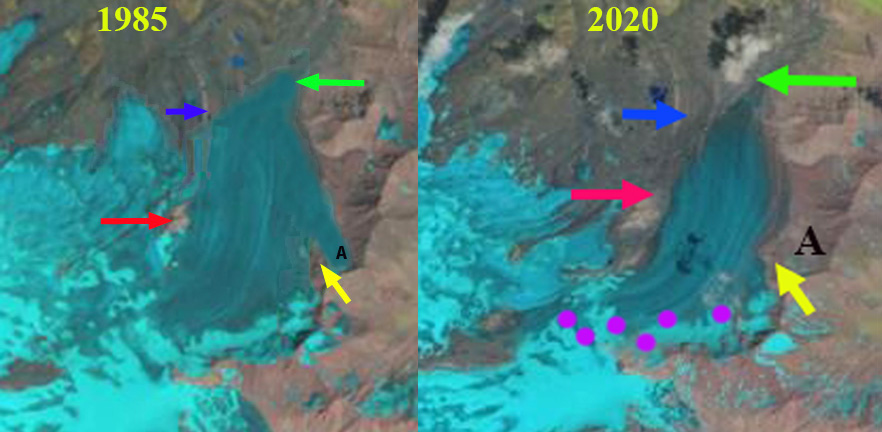
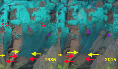
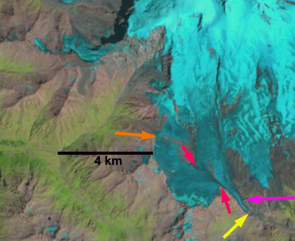
Lekhrziri Glacier in 1996 and 2022 Landsat images illustrating the retreat and separation of the three tributaries central (Lc), eastern (Le) and western (Lw). Red arrow indicates 1996 terminus and yellow arrows the 2022 terminus locations

Lekhrziri Glacier has been the largest glacier in Georgia, and was until 2011 a compound glacier comprised of three tributaries joining a short distance from the terminus (Tielidze et al 2016).  Tielidze et al (2015) observed in 2011 that the central tributary separated from the east and west tributary that year at the headwaters of  the Mestiachala River Basin. From 2000-2020 Lekhziri Glacier experienced the largest retreat, of 1395 m, of 16 large Caucasus glaciers examined by (Tielidze et al 2022). Here we examine Landsat and Sentinel imagery from 1996-2022 to illustrate the changing nature of this glacier.

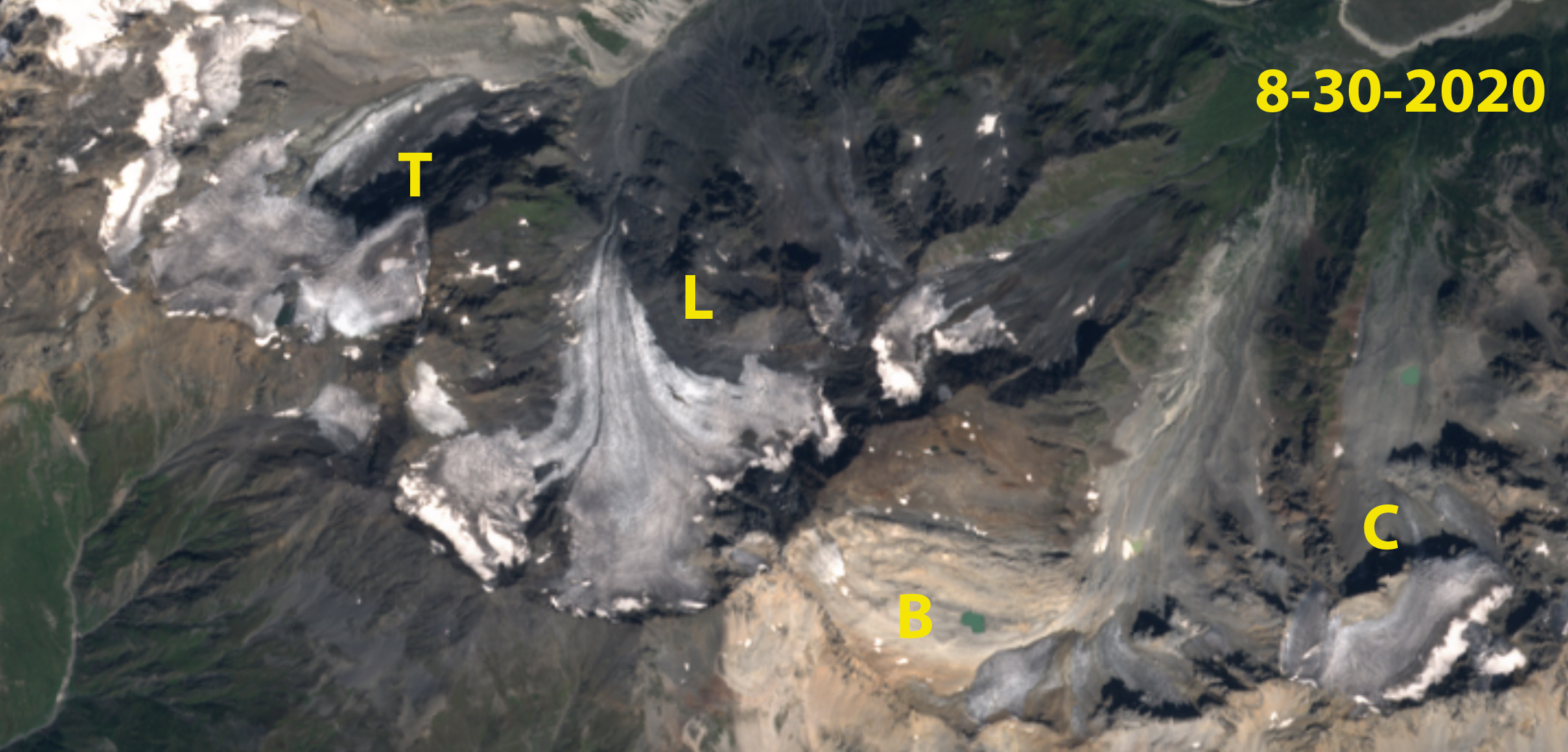
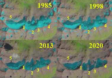
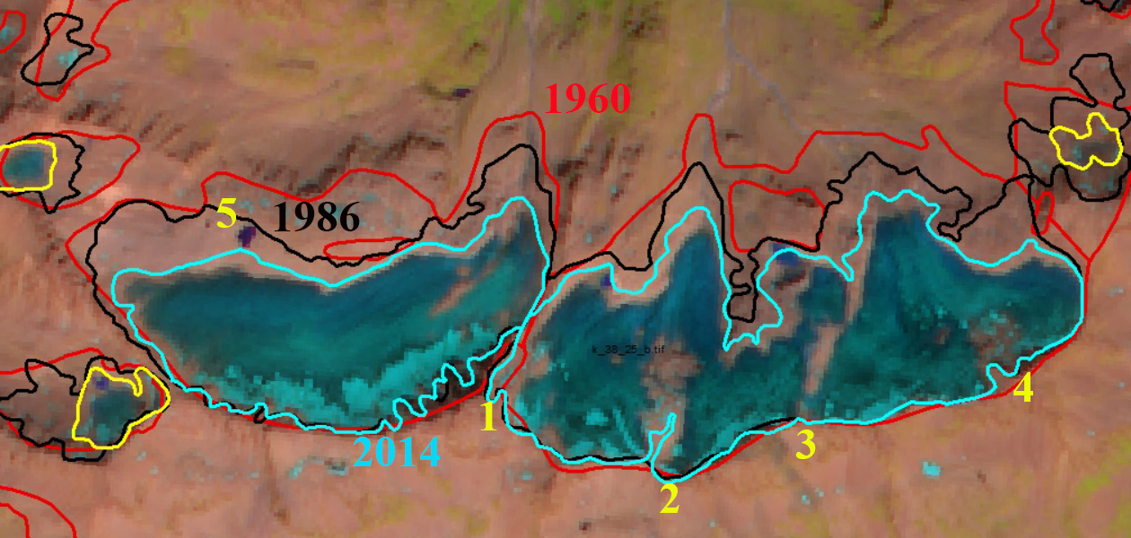
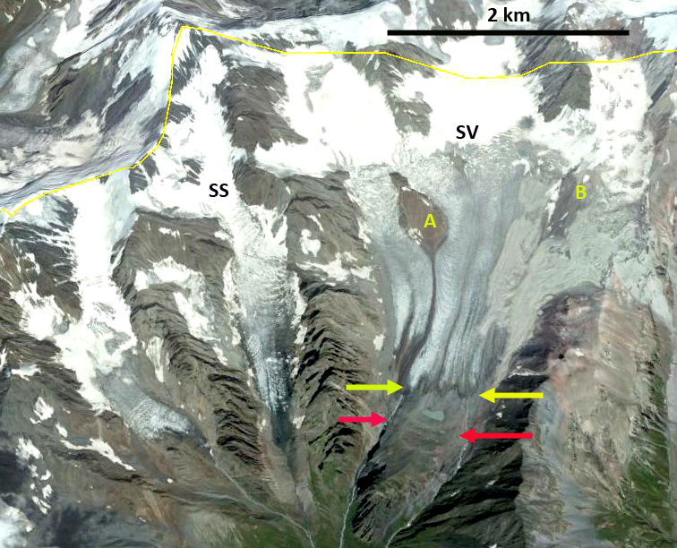
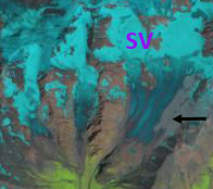
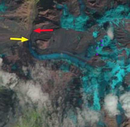
In 1996 the three tributaries joined at 2300 m and then flowed jointly south for 1 km to the terminus, red arrow on Landsat image. The August snowline is at 3300 m. By 2013 the central glacier has visibly separated by 500 m from the other tributaries. The primary terminus has had a retreat of ~500 m since 1996. The August snowline is at 3400 m in 2013. In 2022 additional retreat as separated the east and west tributaries, with an evident river emanating from each tributary, yellow arrows, feeding into the Mestiachala River. The central tributary terminates 800 m from the former junction. The retreat of the east tributary has been 1.3 km since 1996 and the west tributary 1.25 km since 1996. There is also a small lake that is evident, green arrow, in 2022 that will fill in with sediment.  The snowline at the end of August 2022 is at 3450 m. The persistent high snowlines due to warm melt season conditions has led to ongoing mass loss that will lead to continued declines in the Lekhziri Glacier system. This is one example of the widespread retreat of glaciers in the region chronicled by Levan Tielidze. The high snowlines of 2017 and 2022 have been noted for Gora Gvandra glaciers and Zeno Svaneti glaciers.

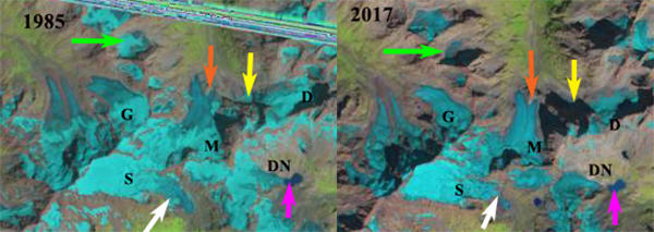
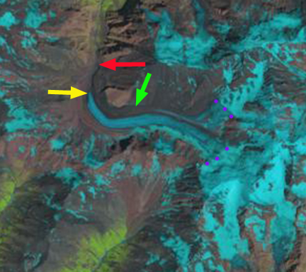
Lekhrziri Glacier in 2013 Landsat image illustrating the retreat and separation of the three tributaries central (Lc), eastern (Le) and western (Lw). Red arrow indicates 2013 terminus and purple dots the snowline.

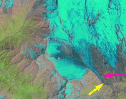
Lekhrziri Glacier in 2022 Sentinel image illustrating the retreat and separation of the three tributaries central (Lc), eastern (Le) and western (Lw). Yellow arrows the 2022 terminus locations aand green arrows the small lake at headwaters of Mestiachala River Basin.

Zemo Svaneti Glaciers, Georgia Not Poised for Survival

Ladevali (L), Tsaigmili (T), Baki (B), and Cherinda Glacier (C) in Sentinel false color image from August 30, 2022. Illustrating that each has 10% or less of the glacier surface retaining snowcover.

Several glaciers at the headwaters of the Doira River in the Zemo Svaneti Planned National Park in the Georgian Caucasus have been stripped of snowpack during recent summers. A glacier without a zone a persistent snowcover throughout the year has no accumulation zone and cannot survive (Pelto, 2010). Here we examine Ladevali, Tsaigmili, Baki and Cherinda Glaciers during August of 2016, 2018, 2020 and 2022 using Sentinel imagery. Tielidze and Wheate (2018)  completed an inventory of Caucasus glaciers documenting the 1986 glacier surface area at 1482 square kilometers decreasing to 1193 square kilometers by 2014, a 20% decline in this 28 year period. Tielidze et al ( 2022) update this inventory identifying a 23% decline in area from 2000 to 2020, greater than 1% per year.

In 1998 ther Ladvali and Tsaigmili Glacier nearly join at the terminus. Baki Glacier spans the entire upper basin and no lake is evident near Point B. Cherinda Glacier descends a bedrock step to form a lower section. In mid-August of 2018 Baki Glacier has lost nearly all snowcover and a new lake has formed adjancent to Point B. Cherlinda Glacier has a fringe 15% along its upper margin and is no longer connected to lower relict ice below the bedrock step. Ladevali and Tsaigmili Glacier have snow cover above 3200 m covering 15-20% of the glacier and the termini are now separated by ~1 km.  At the end of August in 2020 Baki Glacier is snow free. Cherinda has a fringe on its upper maring covering less than 10% of the glacier. Ladevali and Tsaigmili Glacier have snow cover above 3300 m covering ~5% of the glacier. At the end of August 2022 Baki Glacier is again snow free, while Cherinda has a fringe on its upper margin covering 10% of the Glacier. Ladevali and Tsaigmili Glacier have snow cover above 3250 m covering ~10% of the glacier. In 2022 the glaciers also exhibit a lack of retained firn from any recent year, illustrating a consistent lack of retained accumulation.  This consistent minimal retained snowcover illustrates that the glaciers cannot survive current climate. A similar situation has been observed further east at Gora Gvandra. The mass balance in the region has continued to decline with a mean annual loss of ~-0.5 m/year from 2000-2019, (Tielidze et al 2022) with 2020-2022 likely even worse

Ladevali (L), Tsaigmili (T), Baki (B), and Cherinda Glacier (C) in Sentinel true color image from August 30, 2020. Illustrating that each has 10% or less of the glacier surface retaining snowcover.


Ladevali (L), Tsaigmili (T), Baki (B), and Cherinda Glacier (C) in Sentinel false color image from August 16, 2018. Illustrating that each has 20% or less of the glacier surface retaining snowcover with several weeks left in the melt season.

Ladevali (L), Tsaigmili (T), Baki (B), and Cherinda Glacier (C) in Landsat image from mid-August 1998. Ladvali and Tsaigmili nearly join in 1998. Baki Glacier expands across the entire basin and Cherlinda descends below a bedrock step.


Khanasankoi Glacier, Russia Separation and Full Snowcover Loss

Khasankoi Glacier in 1985, 1998, 2013 and 2020 Landsat imagery with Point 1-4 indicating locations where bedrock expansion is occurring with Point 1 and 3 separating the glacier into three parts. Note complete lack of snowcover on 8-26-2020.

Khasnakoi Glacier is a north facing slope glacier just south of Mount Elbrus that drains into the Kuban River. The Greater Caucasus contain approximately 2000 glaciers with a total area of ~1200 km2(Tielidze and Wheate, 2018).  Significant positive trends in annual and summer temperature from 1960-2014 have driven large overall glacier area loss, 0.53% per year, leading to the loss of over 300 glaciers (Tielidze and Wheate, 2018).  Here we examine Landsat images from 1985-2020 to identify key changes of the glacier.

In 1985 the glacier extended 4.6 km from east to west without interruption and featured three primary termini.  The glacier in 1985 has an accumulation area ratio (percent snowcovered) of 60%.  By 1998 there is limited retreat the glacier is still once continuous glacier and the accumulation area ratio is 40. By 2013 at Point 1 a bedrock ridge is emerging. At Point 2 a few outcrops of rock are evident emerging from under the thinning glacier.  The same is the case at Point 4. At Point 5 a new lake has developed at the margin.  The accumulation area ratio in 2013 is 25%.  In 2020 the accumulation area ratio is 0% snowcover.  A pair of ridges now bisect the glacier at Point 1 and Point 3. At Point 2 the rock outcrop has expanded into one large region.  At Point 4 a bedrock area has expanded at the head of the glacier.  At Point 5 retreat has left the newly formed lake of less than a decade ago isolated from the glacier.  This is not the first year of poor snowcover.

The mapped boundary of the glacier below provided by Levan Tieldze illustrates the glacier boundary in 1960, 1986 and 2014, illustrating a 29% decline in area. The loss of snowcover in 2020 is not the first summer when this has been observed in the Caucasus in 2017 Gora Gvandra did not retain snowcover. For Dzhikiugankez Glacier on the slopes of Mount Elbrus there has been a persistent low snowcover by end of summer since 2013. Tieldze (2019) explained the connection of climate to receding glaciers in the Caucasus using Tviberi Glacier in Georgia as an example.

Image from Levan Tieldze indicating the extent of the glacier in 1960 (red), 1986 (black) and 2014 (blue) on a 2016 SPOT image. There is still some connection above Point 1.

Map of the region from when Khasankoi Glacier was contiguous.

Dzhikiugankez Glacier, Russia Persistent Limited Retained Snowpack 2013-2020

Dzhikiugankez Glacier in 1985 and 2020 Landsat images with the snowline shown by purple dots. A tributary at Point A has disappeared and tributary at the red arrow has separated.  Thinning and marginal retreat is emphasized by blue and green arrows.

Dzhikiugankez Glacier (Frozen Lake) is a large glacier on the northeast side of Mount Elbrus, Caucasus Range. The primary portion of the glacier indicated in the map of the region does not extend to the upper mountain, the adjoining glacier extending to the submit is the Kynchyr Syrt Glacier. The glacier is 5 km long extending from ~4000 m to 3200 m.  Shahgedanova et al (2014) examined changes of Elbrus glaciers from 1999-2012 and found a 5% area loss in this short period, with accelerattion retreat from the 1987-2000 period.  Of the glaciers on Elbrus over 10 km2 in area Dzhikiugankez Glacier experienced a high rate of reduction, the relative loss was 27% between 1960 and 2014 (Tielidze and Wheate, 2018). This is driven by a persistent lack of retained snowcover, here we examine Landsat imagery to illustrate that. This post is inspired by the frequent imagery of Caucasus glacier change posted on Twitter by @LevanTielidze.

In 1985 the glacier connects beneath the subsidiary rock peak at the red arrow, a tongue of ice extends on the east side of the rock rib at the yellow arrow, Point A. The transient snow line is at 3550 m and less than 30% of the glacier is snowcovered. The medial moraine at the blue arrow is just beyond the glacier terminus, green arrow. In 2013 a wide zone of bare rock extends up to the subsidiary peak at the red arrow and the glacier has separated from the western tributary.  The medial moraine, blue arrow is exposed all the way to its origin near the red arrow.  In 2013 the tongue of ice at Point A, is gone.  This glacier is retreating faster on its lateral margins than at the terminus, a 20% reduction between red and yellow arrows from 1985 to 2013. In 2013 the snowline is at 3600 m, with several weeks of the melt season left.

In 2018 the transient snowline near the end of the melt season is at 3900 m, leaving less than 10% of the glacier snowcovered. In 2019 the transient snowline is at 3800 m near the end of the melt season leaving 10-15% of the glacier snowcovered. In mid-July 2020 the transient snowline is already at 3600 m with at least 6 weeks left in the melt season. It is evident from the Landsat images from the 2013 to 2020 period that  Dzhikiugankez Glacier consistently has the lowest percent of overall snowcover on Elbrus and too small of an accumulation zone to persist. The limited snowcover and glacier separation in also seen at Azaubashi Glacier  on Mount Elbrus


Dzhikiugankez Glacier in 2013, 2018 and 2019 Landsat images with the snowline shown by purple dots. 

Map of northeastern side of Mount Elbrus, summit on left. Dzhikiugankez Glacier (Dzhikaugenkjoz) is outlined in black.

Gora Gvandra Glaciers, Caucasus Mountains, No Accumulation Zone in 2017

Comparison of glaciers around Gora Gvandra, Caucasus Mountians in 1985 and 2017 Landsat images.  G=Gvandra Glacier, D=Dalar galcier, DN =North Dalari Glacier, S=Sakeni Glacier and M=Morde Glacier. 

Gora Gvandra Mountain is southwest of Mount Elbrus of the Caucasus Mountains of Georgia and is surrounded by a group of glaciers that in recent years have not exhibited an accumulation zone.  Stokes et al (2006) note that 94% of Caucasus Mountain glaciers retreated from 1985 to 2000. Tielidze and Wheate (2018) updated these observations to 2014 documenting the 1986 glacier surface area at 1482 square kilometers decreasing to 1193 square kilometers by 2014, a 29% decline. Here we examine Landsat images from 1985 to 2017 to illustrate the profound changes. In 2017 five of the six glaciers in the area had no retained snowpack, like the Alps this was a summer of high melt.

A comparison from 1985 to 2017 of Dalari North Glacier (DN), pink arrow indicates the glacier ending in a lake in 1985 and 1998, and terminates short of the lake in 2013.  In 2013 the accumulation zone is small and in 2017 the accumulation zone does not exist. Note the contraction of the unnamed glacier from 1985-2017 at the green arrow, with an expanding bedrock area in the midst of what was the glacier and no retained snow in 2017. The Morde Glacier (M) terminus separated around a bedrock knob at the orange arrow in 1985 and the western arm terminates beyond the knob. The glacier has retreated 400 m by 2017, driven by a the lack of an accumulation zone with no retained snowpack in 2013 or 2017.  The terminus of Dalar Galcier (D), yellow arrow, is below a steep slope in 1985 and 1998.  By 2013 the steep slope is bare rock separating the former terminus from the rest of the glacier.  In  2017 there is no retained snowpack on the glacier.  Gvandra Glacier has lost all of its snowpack in 2017. The Sakeni Glacier has a 500 m wide terminus tongue in 1985 and 1998, white arrow.  By 2013 and in 2017 the tongue has narrowed to 150 m and is going to either separate from the upper glacier or melt away soon. There is retained snowpack on the upper part of Sakeni Glacier in each year.

Of the six glaciers examined only one glacier had an accumulation zone in 2017 and in 2013 the accumulation zone was only significant on one glacier.   Pelto (2010) noted that a glacier cannot survive without a persistent and consistent accumulation zone.  This has been noted to be case even on some larger glacier of Mount Elbrus. Psysh Glacier in the western Caucasus is also disappearing.

Comparison of glaciers around Gora Gvandra, Caucasus Mountians in 1985 and 2017 Landsat images. yellow arrow=Dalar glacier, pink arrow=North Dalari Glacier, whtie arrow=Sakeni Glacier and orange arrow=Morde Glacier.


Azaubashi Glacier Fragmenting, Mount Elbrus, Russia

Azaubashi Glacier (W) and Azau Glacier (A) in 1985 Landsat and 2016 Sentinel Image. Orange arrows indicate particular areas of fragmentation and bedrock expansion.  Pink arrows indicate connection  with Azau Glacier the terminus of which in 1985 is at red arrow and in 2016 is at yellow arrow. 

Azaubashi Glacier is on the southwest side of Mount Elbrus, Caucasus Mountains of Russia, merging with the Greater Azau Glacier. The glacier drains east from Gora Azaubashi (3600 m).  The glacier is west of the ski complex at Prielbrusye, that has lifts from Azau at 2300 m to Krugozor at 3000 m and Mir at 3500 m.  Shahgedanova et al (2014)  report  glaciers on the mountain experienced a 5% loss in area from 1999-2012, with the Azaubashi Glacier losing a much higher percentage.

Azaubashi Glacier (W) and Azau Glacier (A) in 1998 and 2013 Landsat Images. Orange arrows indicate particular areas of fragmentation and bedrock expansion.  Pink arrows indicate connection  with Azau Glacier the terminus of which in 1985 is at red arrow and in 2016 is at yellow arrow. 

Here we examine Landsat images from 1985 to 2016 to quantify the substantial change. In 1985 the glacier extends north from Azaubashi to join with glaciers on the upper slopes of Elbrus in a 4 km continuous sweep.  At Arrow 1 and 2 the glacier is continuous and extends at least 800 m from top to bottom.  At Arrow 3 the glacier connection with Azau Glacier is extensive.  At Arrow 4 the glacier extends to the ridge.  By 1998 At Arrow 1 a bedrock arrow has nearly separated the glacier.  At Arrow 2 the glacier remains at least 700 m from top to bottom. The connection between Azaubashi and Azau Glacier remains extensive.  At Arrow 4 the glacier extends to the ridge.  By 2013, the bedrock exposed at Arrow 1 is 300 m wide.  At Arrow 2 the glacier is nearly severed with a connection of just 300 m.  At Arrow 3 the connection between glaciers is now discontinuous and tenuous.  At Arrow 4 the glacier no longer extends to the ridgeline,  The snowline on the south side of Mount Elbrus is at 3700 m. In 2016 the main change is the continued disconnection between Azaubashi Glacier and Azau Glacier, the connection that in 1985 was 1500 m long is now just 500 m long. The glacier will soon be split into three sections. The glacier did not retain any snowcover in 2016, in 1998 and 2013 less than 10% of the glacier retained snowcover.  The snowline in 2016 was at 3700 m on Aug. 28th. This indicates a glacier that cannot survive current climate as it lacks a consistent significant accumulation zone.  The retreat from 1985 to 2016 of the Azau Glacier noted at the red and yellow arrows has been 650 m.   The Azau Glacier still has an extensive accumulation zone.  TheAzaubashi Glacier is similar to the Dzhikiugankez Glacier in losing mass across nearly its entire surface.

Azaubashi Glacier in 2009 Google Earth image. Orange arrows indicate particular areas of fragmentation and bedrock expansion.  Pink arrows indicate connection  with Azau Glacier, blue arrows indicate two small lakes developing in previously glacier covered areas. 

Suatisi Glacier Retreat, Mount Kazbek, Georgia

Suatisi compare

Comparison of Suatisi Vost (SV) and Suatisi Sredny (SS) in 1986 and 2015 Landsat images.  The red arrow is the 1986 terminus and the yellow arrows the 2015 terminus.  Point A and B are to areas of expanding bedrock amidst the glacier. 

Suatisi Vost and Suatisi Sredny Glacier are two glaciers on the south flank of Mount Kazbek in northern Georgia.  The region is prone to landslides and debris flows. On September 20, 2002 a collapse of a hanging glacier from the slope of Mt Dzhimarai-Khokh onto the Kolka glacier triggered an avalanche of ice and debris that went over the Maili Glacier terminus then slid over 15 miles (NASA Earth Observatory, 2002). It buried small villages in the Russian Republic of North Ossetia, killing dozens of people. The glacier runoff from Suatisi Glacier supplies the Terek River, which has a hydropower project under construction.  The Dariali Hydroplant will have an installed capacity of 108 MW and is a run of river type plant near Stepantsminda, Georgia. This plant has suffered from two landslides in 2014 (Glacier Hub, 2014) that jeopardize its completion.

Shagadenova et al (2014) examined glaciers in the Caucasus mountains and found that from 1999/2001 and 2010/2012 total glacier area decreased by 4.7%. They also noted that recession rates of valley glacier termini increased between 1987– 2000 and 2001–2010, with the latter period featuring retreats averaging over 10 m/year.  A positive trend in summer temperatures forced glacier recession (Shagadenova et al 2014). Here we examine changes in Suatisi Glacier from 1986 to 2015 with Landsat imagery.

In 1986 Suatisi Vost western side terminates at the top of deep canyon, red arrow.  The eastern side of the terminus is on a flatter till plain.  The area around Point B is all glacier ice.  Suastisi Sredny terminates near the end of the valley it occupies in 1986.  In the 2001 image a large debris flow/landslide has covered the eastern margin of Suatisi Vost surrounding the area of Point B, black arrow in 2001 image below.  By 2010 the Google Earth image indicates significant retreat of Suatisi Vost and the debris flow below point B is a light gray color. The bedrock at Point B has expanded.   By 2015 Suatisi Vost terminus has retreated 350 m since 1986, what is just as evident is the loss in width of the terminus in the 1986-2015 side by side comparison. Suatisi Sredny has retreated 450 m.  The snowline is at an elevation of 3750-3800 m in 1986, 2010 and 2015. With the terminus at 3250 m and the highest elevation at 3950-4000 m, this is too high to sustain the glacier at its current size and retreat will continue. The debris cover has reached the terminus on the east side of the glacier by 2015. The changes are the same across the border in Russia, for example Lednik Midagrabin.

suatisi ge

2010 Google Earth image of Suatisi Vost and Suatisi Sredny.  

suatisi 2001

2001 Landsat image indicating the landslide covering surface of Suatisi Vost.

suatisi j2015

2015 Landsat image indicates Landslide deposit evolution, with movement downglacier and retreat, it is now close to the ice front on the east side of the margin.

Lednik Midagrabin Retreat, Caucasus, Russia

Lednik Midagrabin is a large glacier draining northwest from Gora Dzhimara in North Ossetia, Russia.  Stokes et al (2006)  examined Caucasus glaciers during the 1985-2000 period and found that 94% of the glaciers have retreated, 4% exhibited no overall change and 2% advanced. The mean retreat rate is 8 m/year, with the largest glacier retreating the fastest. Shahgedanova et al (2009) observed that the retreat was driven by a large rise in summer temperature in the alpine zone, and that this will continue and generate substantial changes in the timing and amount of glacier runoff.  Here we examine the changes in this glacier from 1989-2015. This region has had a particularly warm start to the melt season in 2015 prompting this examination, note the NOAA temperature anomaly for the Caucasus Region.

midagrabin 2010 ge

Google Earth Image

201506


NOAA 2015 Temperature departure map for June 2015 with the Caucasus region indicated.

The glacier begins on the slopes of Dzhimarra at 4200 m and in 1989 the glacier terminated at the red arrow at 2950 m.  The snowline at the end of August, 1989 was 3700 m.  The green arrow indicates the extent of the clean blue glacier ice of the tributary from the north  In 2014 the glacier had retreated to a terminus location at the red arrow.  The snowline at the end of August 2014 was at 3800 m.  In mid-July of 2015 the snowline has already reached 3700 m, with the melt season only half over.  This will lead to substantial mass loss.  The main terminus has retreated to the yellow arrow a distance of 900-1000 m since 1989 and now terminates at 3050 m.  This is close to the maximum rate of 38 m/year identified by Stokes et al (2006) for the any glacier in the mountain range from 1985-2000.  This indicates Midagrabin is one of the faster retreating glaciers in the Caucasus and that the rate of retreat has increased.  The northern tributary clean ice zone has been reduced in length and width, now terminating 600 m further upglacier.  The northern tributary has had little retained snowpack in 2014 and again in 2015.  The tributary begins at 4000 m, which is not high enough in recent years to sustain this arm of the glacier.  The high snowlines of recent years will lead to continued retreat. The glacier poses little geologic hazards of flooding compared to some other retreating glaciers in the area such as Bashkara Glacier.

Midagrabin 1989

August 1989 Landsat Image

midAGRABIN 2014

August 2014 Landsat Image

midagrabin 2015

July 2015 Landsat image


Dzhikiugankez Glacier Poised to Melt Away, Mount Elbrus, Russia.

Dzhikiugankez Glacier (Frozen Lake) is a large glacier on the northeast side of Mount Elbrus, the highest mountain in the Caucasus Range. The primary portion of the glacier indicated in the map of the region does not extend to the upper mountain, the adjoining glacier extending to the submit is the Kynchyr Syrt Glacier. The glacier is 5 km long extending from 4000 m to 3200 m. Shahgedanova et al (2014) examined changes in Mount Elbrus glaciers from 1999-2012 and found a 5% area loss in this short period and accelerated retreat from the 1987-2000 period. As examination of Landsat images indicates Dzhikiugankez Glacier has the lowest percent of overall snowcover, as seen in the satellite image from August 2013 with the transient snow line shown in purple. The amount of blue ice is apparent on Dzhikiugankez Glacier (D). The main changes in this glacier are not at the terminus, but along the lateral margins, indicating substantial vertical and lateral thinning. Here we examine Landsat imagery from 1985 to 2013 to identify changes. In each image the red arrow indicates bedrock on the western margin, the yellow arrow bedrock on the eastern margin, Point A an area of glacier ice extending to the upper eastern margin, the purple arrow a medial moraine exposed by retreat and the green arrow the 1985 terminus of the glacier.

Elbr01
Map of northeastern side of Mount Elbrus, summit on left. Dzhikiugankez Glacier (Dzhikaugenkjoz) is outlined in black.

elbrus glaciers tsl 2013
August 2013 Satellite image of Mount Elbrus

kinger sirt ge
Google Earth image 2013

In 1985 the glacier connects beneath the subsidiary rock peak at the red arrow, a tongue of ice extends on the east side of the rock rib at the yellow arrow, Point A. The transient snow line is at 3550 m and less than 30% of the glacier is snowcovered. The medial moraine at the purple arrow is just beyond the glacier terminus. In 1999 the subsidiary peak is still surrounded by ice and the tongue of ice at Point A though smaller is still evident. The snowline is quite high extending to 3750 m, leaving only 10-15% of the glacier snowcovered. In 2001 the main terminus has retreated from the green arrow. A strip of rock extends up to the red arrow. The snowline is at 3500 m, with a month of melting left. In 2013 a wide zone of bare rock extends up to the subsidiary peak at the red arrow.  The medial moraine, purple arrow is exposed all the way to its origin near the red arrow.  In 2013 the tongue of ice at Point A, is gone.  This glacier is retreating faster on its lateral margins as  at the terminus, a 20% reduction between red and yellow arrows from 1985 to 2013. The snowline is at 3600 m, with several weeks of the melt season left. The key problem for the Dzhikiugankez Glacier is that there is an insufficient persistent accumulation zone.  Pelto (2010) noted that a glacier cannot survive without a persistent and consistent accumulation zone, which Dzhikiugankez Glacier lacks despite being on the flanks of Mount Elbrus. Retreat of this glacier is similar to Azau Glacier, particularly the west slope of this glacier, and Irik Glacier.  Unlike these glaciers it cannot survive current climate.  The glacier is large and the glacier will not disappear quickly. Shahgedanova et al (2014) note the expansion of bare rock areas adjacent to glaciers on the south side of Mount Elbrus including Azau and Garabashi.

lednik ks 1985
1985 Landsat image

lednik ks syrt 1999

1999 Landsat image
lednik ks 2001
2001 Landsat image

lednik ks 2013
2013 Landsat image

Greater Azau Glacier, Mount Elbrus, Russia

Greater Azau Glacier is on the south slopes of Mount Elbrus, Caucasus Mountains of Russia. The glacier is just west of the ski complex at Prielbrusye, that has lifts from Azau at 2300 m to Krugozor at 3000 m and Mir at 3500 m. This glacier like others on Mount Elbrus and in the Caucasus Mountains is retreating. Russian Academy of Sciences remapping of the glaciers on the mountain indicate a 15% loss in area from 1911 to 1957 and 7% loss from 1957-2000. elbrus glaciers
2013 Landsat of Mount Elbrus and its glaciers.

azau ge
2009 Google Earth image of Azau Glacier.

In 1998 the glacier descended to an elevation of 2650 m ending at the yellow arrow. The pink arrow indicates a knob adjacent to the 2013 terminus. The red arrows indicate the length of the connection of the slope glacier to the west of the main valley tongue of the Azau Glacier, it is 1 km. The orange arrows indicates a thin connection between two segments of the upper glacier on the western slopes above Azau Glacier. IN 2001 the terminus has retreated a short distance from 1998. By 2013 the terminus has retreated 450 m to just beneath the knob at the pink arrow, 30 m per year. The terminus is now at 2850 meters. The glacier on the western slopes has separated at the orange arrow and the connection at the red arrows has been reduced to 200 meters from 1000 meters in 1998. A close up view of the terminus in 2009 indicates that it is still just downvalley of the prominent knob. Only the lower 300 m of the glacier is uncrevassed, above this point active crevassing is widespread. The Krugozor Ski Station is also noted. This glacier is retreating faster now than during the 1957-2000 period like the Irik Glacier to the east on Mount Elbrus. This likewise is the pattern of retreat observed elsewhere in the Caucasus at Gora Bashkara,Kirtisho Glacier and Lednik Karaugom Glacier. The glacier still has an extensive accumulation zone.
azau glacier 1998
1998 Landsat image

azau glacier 2001
2001 Landsat Image

azau glacier 2013
2013 Landsat Image

azau terminus
2009 Google Earth Image