Cook Ice Cap Retreat & Nunatak Expansion, Kerguelen Island

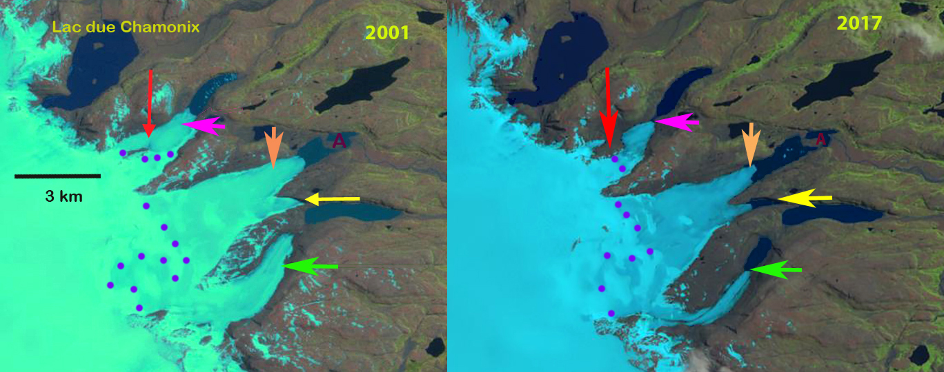
West margin of Cook Ice Cap in 2001 and 2018 Landsat images.  Red arrows indicate terminus margin in 2001 in both images. Nunataks A-D and Nunatak Lacroix (L) are also shown.

On the west side of the Cook Ice Cap on Kerguelen Island a series of outlet glaciers have retreated and several nunataks have either expanded or are no longer surrounded by ice.   The glacier include Pasteur, Pierre Curie, Larmarck and Descartes from north to south. Here we examine the changes from 2001-2018 along using Landsat imagery.  This is a very cloudy region and no other images allowed a clear view, except a Sentinel image also from 2018. Retreat of glacier in the region was examined by Berthier et al (2009) and is exemplified by the retreat of Ampere Glacier.  Verfaillie et al (2016)examined the surface mass balance using MODIS data, field data, and models.  They identified that accelerating glacier wastage on Kerguelen Island is due to reduced net accumulation and resulting rise in the transient snowline since the 1970s, when a significant warming began.

On the west side of Cook Ice Cap in 2001 there is one significant Nunatak in the midst of the ice cap Nunatak Lacroix (L). Nunatak A and D do not exist.  Nunatak C is encircled by ice and Nunatak B is nearly surrounded. Pasteur Glacier reaches tidewater across a broad front in 2001. By 2018 Nunatak D has emerged 1.2 km inland from the margin. Nunatak A has also emerged 4.0 from the ice margin. Nunatak C is now a ridge separated from the ice cap. Lacroix Nunatak is much expanded. Pasteur Glacier is narrower has retreated 600 m and does not reach tidewater, but terminates on a proglacial delta. Pierre Curie Glacier 1.2 km and is now just 2 km from the ice cap margin. Lamarck Glacier that terminated in a proglacial lake has now retreated from that lake, a retrated 1100 m.  Descartes Glacier  has retreated 1000 m with a narrow arm of the lake extending northward. A new proglacial lake has also formed down glacier of Nunatak D.  The retreat of the western margin of the Cook Ice Cap supports the mass balance losses determined by  Verfaillie et al (2016).  The east side of the Cook Ice Cap is also retreating forming a new lake district.

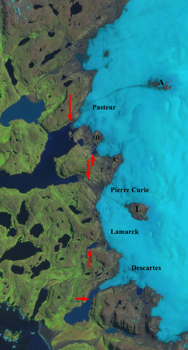
West margin of Cook Ice Cap in  2018 Sentinel image.  Red arrows indicate terminus margin in 2001 in both images.  Nunataks A-D and Nunatak Lacroix (L) are also shown. Retreat of outlet glaciers at the five arrows is 900 m.


Cook Ice Cap Outlet Glacier Retreat Lake Fromation, Kerguelen 2001-17


Comparison of eastern outlet glaciers of the Cook Ice Cap in 2001 and 2017 Landsat images.  Red arrow indicates a location of tributary separation. Pink arrow the 2017 terminus location of the northernmost glacier. Orange arrow the 2017 terminus location of the middle glacier.  Yellow arrow tip the 2001 terminus position of glacier ending in newly formed lake.  Green arrow the southernmost glacier 2017 terminus location. 

On the east side of the Cook Ice Cap on Kerguelen Island a series of outlet glaciers have retreated expanding and forming a new group of lakes.  Here we examine the changes from 2001-2017 along using Landsat imagery. Retreat of glacier in the region was examined by Berthier et al (2009) and is exemplified by the retreat of Ampere Glacier.  Verfaillie et al (2016) examined the surface mass balance using MODIS data, field data, and models.  They identified that accelerating glacier wastage on Kerguelen Island is due to reduced net accumulation and resulting rise in the transient snowline since the 1970s, when a significant warming began.

In 2001 at the red arrow is where the north tributary of a glacier ending in the northern most lake joins the main glacier.  In the second lake is a peninsula, marked with point A that the glacier terminus is 1 km from. The next two glaciers terminating at the yellow arrow and beyond the green arrow do not have lakes at their termini.  By 2014 the northern tributary has lost its connection with the main glacier terminating in the lake. The distance from the island for the middle glacier has increased.  A lake is forming at the yellow arrow. For the third glacier a lake has formed at the green arrow. In 2017 the northern glacier has retreated to the pink arrow a distance of  750 m and is no longer terminating in the lake. The terminus at the orange arrow has retreated  main terminus has retreated 900 m, expanding the lake it terminates in.   The glacier at the yellow arrow has retreated into a new lake basin, with a retreat of 850 m since 2001. The terminus is thin and in the Google Earth image indicates some substantial thin icebergs have separated from the glacier. The green arrow marks the 2017 terminus of the southern most lake. This glacier has retreated 950 m leading to the continued expansion of a new lake.  In just a decade we see the formation of two new lakes and the expansion of two others at the terminus of the eastern outlet glaciers of Cook Ice Cap, rapid landscape change driven by climate change.

2014 Landsat image of the eastern outlet glaciers of Cook Ice Cap.Red arrow indicates a location of tributary separation. Pink arrow the 2017 terminus location of the northernmost glacier. Orange arrow the 2017 terminus location of the middle glacier.  Yellow arrow tip the 2001 terminus position of glacier ending in newly formed lake.  Green arrow the southernmost glacier 2017 terminus location. 

Terminus of three outlet glaciers from left to right the green arrow, yellow arrow and orange arrow terminus glacier on the Landsat images.  The green arrows indicate places where the terminus or icebergs illustrates how thin the glacier ice is.