
In the USGS map for Mount Daniels-Mount Hinman in the North Cascades, Washington based on 1958 aerial photographs, overlain in Google Earth. Hinman Glacier is the largest glacier in the North Cascades south of Glacier Peak. Today it is nearly gone. Hinman Lake, unofficial name, has taken the place of the former glacier, which still has a couple of separated relict ice masses. From 1984-2007 all 47 glaciers observed by the North Cascade Glacier Climate Project receded. Hinman Glacier has had one of the more dramatic retreats. Immediately below is the 1965 Mount Daniels Quadrangle USGS map of the glacier. The glacier extends from the top of Mount Hinman at 7600 feet to the bottom of the valley at 5000 feet. The next image is of Hinman Glacier from the west in 1988,the Hinman Glacier is now a group of four separated ice masses, three are significant in size still. The third image in the sequence is the 1998 aerial image of the glacier a few areas of blue ice are seen, the glacier is 20% of its mapped size. There are still three sections of remanant blue glacier ice. The next picture in the chain is the glacier in 2006, from a Google Earth image,at this point the glacier is no longer detectable under the snowcover, note the map outline and the gorgeous new unnamed Lake Hinman. The new lake 0.6 miles (one kilometer long). Lastly is a 2009 view from the far end, north end of Lake Hinman up the valley and mountain side that was covered by the Hinman Glacier, now 90% gone. Each of the two larger ice masses from 1998 is now divided into at least two smaller portions. This is no longer a glacier and is just a few relict pieces of ice, the largest has an area of 0.05 square kilometers. 


Category: Uncategorized
Denali National Park, East Taklanika Glacier retreat
The glaciers of Denali National Park are shrinking. The National Park Service has been chronicling the retreat with repeat photographs of glaciers from locations where historic photographs exist. The program has been a cooperation between glaciologist Guy Adema and photographer Ron Karpillo. One example is East Taklanika Glacier. This glacier drains north from the east ridge of Mount Scott. The glacier is currently 5.1 km long, the lower 2.2 km of the glacier is nearly completely debris covered. That ice is beneath the debris is clear from the lack of a the glacier melt fed river in the valley bottom and the color of the sediments which is darker, largely because the debris is wet from the ice melt underneath. The glacier in the center of the Google Earth satellite view below is East Taklanika Glacier.  The glacier has retreated 1100 m between 1916 and 2004 in the phtographs of Ron Karpillo and Stephen Capps. There is a lateral moraine in the foreground of the 2004 Ron Karpillo image. This marks the former surface elevation of the glacier during the Little Ice Age. Since that time the lower section of the glacier has lost over 100 m of ice thickness.
 The retreat is ongoing. Medial moraines are bands of debris on the surface of a glacier that separate tributaries of a glacier. The moraines represent material eroded from the edge of the tributaries before they join. This material does not appear at the surface until you reach the ablation zone where melting dominates. In the accumulation zone such debris bands would be buried. On East Taklanika Glacier the debris bands extend to within 1 kilometer of the head of the glacier. For a glacier to be in equilibrium a glacier needs to have at least 50 % of its area in the accumulation zone at the end of the summer. Based on the satellite image hear showing 10% of its area in the accumulation zone and the extent of the medial moraine indicating no more than 25% of the glacier area above the moraine. This glacier needs to lose the lower 2-3 kilometers to be in equilibrium. This may not be enough. A glance at the glaciers around East Taklanika, indicate the same story, very little retained snowpack. Some of these glaciers have an accumulation area ratio (% of glacier snow covered at the end of the summer), of zero. This is like having no income, and plenty of expenditures and the result for your bank account, net loss and without some change eventual bankruptcy. The story of retreat is the same though the snowpack extent greater on the Juneau Icefield. The retreat of East Taklanika is slowed considerably by the debris cover which protects the ice underneath from melting as fast. This glacier is a long way from completing its retreat to adjust to current climate.
Snowmaking for Alpine glaciers; where there are enough skiers there is a way.
Snowmaking on glacier’s, sounds like an oxymoron. However, several ski resorts in the Alps have begun doing just that to trying to offset the increased melting of glaciers that occupy a portion of their resorts. This is a more practical application than the insulating blanket that has been used at the Pitzal resort.
On the Pitzal Glacier, Austria they have begun using the IDE All Weather Snowmaker, which can produce snow in above-zero temperatures without chemical additives. This system, which produces snow directly on the slope at any temperature and without chemical additives, was installed in the Pitztal for the first time in Europe and at the same time as in Zermatt (Switzerland). The artificial snow cover forms a buffer layer on top of the glacier and prevents glacial melting. This also covers the glacier ice with a skiable surface. The high temperatures in recent years on the Pitztal Glacier were often not right in early autumn for producing normal snowfall so Dr. Hans Rubatscher, Manager of the Pitztal Glacier Railway, is employing a new way. In the future, the Snowmaker will be used alongside the existing snowmaking equipment, in particular at the start of the season in autumn and in late spring. This brings numerous benefits to the Pitztal Glacier optimizing ski run conditions, earlier opening of the slope section by the base station of the Pitz-Panorama Railway. The potential is emphasized by the interest of several ski teams who have expressed great interest in this special facility at the Pitztal Glacier. The 15m high production tower for the snow has been set up in its own building at an altitude of 2,840m right by the base station of the Pitz Panorama Railway. Below is the output of the snow with the glacier in the background
 The snow produced here can be channeled directly onto the slopes below by the Gletschersee chair lift. The water for this innovative snow production system will be extracted using a vacuum system from the existing storage pools on the Pitztal Glacier. These pools are filled exclusively with melted glacier water, thus forming an ecological cycle on the glacier, returning its own meltwater as snow. After gaining experience, concrete attempts will be made to use the snow created by the Snowmaker to preserve the substance of the glacier in Austria’s highest glacier ski area. The glacier seen below has in most years been bare by late summer, not a skiable condition. The net volume loss of the glacier has also been notable.
In Zermatt’s case the snow is being used to make a path between the bottom of its high altitude glacier and the cable car station from where skiers and boarders can get back up the slopes to access the year round ski area. In years gone by the glacier did reach this lift station anyway, but over the past two decades it has melted away and in summer and autumn there may be no snow cover at all.
The IDE snowmaking system was developed by an Israeli company best known for its water desalination products. It created cooling systems for mines, which to their surprise produced snow as a by-product even under the scorching sun. The “Snowmaker system” can produce approximately 1900 cubic meters of snow in 24 hours whatever the outside temperature, humidity, and wind speed, and is highly energy-efficient. With traditional snowmaking systems, the temperature has to be at least minus 6 degrees Celsius and the humidity no more than 60 percent. With the IDE Snowmaker, these factors don’t come into the equation.
Currently 15% of the Tignes French ski area is covered by snow making canons and it is not just low lying areas. Tignes has equipped the bottom of the runs of the Glacier du Grande Motte with snow making to extend the summer ski season at 3000 meters and Val d’Isère is doing the same on the Glacier du Pisaillas to assure the summer skiing. The lift tower on Glacier Pissaillas is on the right of the image, the bare ice is not good ski conditions. Snow cannon shown at Tignes. 


Stubai Glacier’s Protective Blanket
The north facing side of the Stubai Glacier, also referred to as the Schaufel Ferner, that comprises the biggest ski area in the area is open all summer down to the Eisgrat lift station. There are two main lifts that traverse up the glacier, some of the towers for the ski lifts are set right on the glacier. The linear features extending down glacier in this satellite view of the glacier are the ski lifts and the ski runs.  The Stubai Glacier has been retreating and thinning significantly as have most all glaciers in the Alps. Austria has a long term program monitoring the terminus position of over 100 glaciers. From 2000-2005 of the 115 glaciers observed and reported to the World Glacier Monitoring Service, all 115 experienced net retreat. The mass balance of Austrian glaciers, which represents volume loss, reported to the WGMS has been averaging a loss of more than 0.5 m per year since 1998. The loss of 5 m of ice in a decade on glaciers like the Stubai represents about 10% of their volume lost this decade. Stubai Glacier has experiences a 33% loss in its area since 1969 shrinking from 1.72 to 1.15 square kilometers (Aberman and others, 2009). This ongoing ice loss prompted the ski area in 2003 to begin to explore means to preserve the glacier and maintain there ski season. They turned to the University of Innsbruck’s Andrea Fischer and Marc Olefs, who explored three means to reduce the summer melting. Olefs and Fisher (2007) Innsbruck University.The first was injecting water during the winter into the cold snowpack to make it denser. This did add mass, but did not reduce the melt rate. The second methods was to pack down the snow periodically in the winter, again making it denser. Likewise this did not reduce ablation. This is not surprising given that ablation rates on dense ice and less dense snow are very similar on glaciers. The third method was to cover the glacier with a blanket, they used both felt and plastic. The plastic was more reflective, thinner and easier to deploy and as seen in the next two photographs blends in well with the glacier surface. The top image is from Ineedsnow.com.
 This technique reduced ablation by 60%. Is snow making now being employed a better answer? The problem is that even one small glacier ski slope is still a large area to cover. Because of this success in 2005, the ski resort continues to employ these white polyethylene sheets to reduce melting in strategic areas on the glacier. They are typically spread out in May. The sheets can be seen emplaced around the lift towers in particular. The bare ice of the main section of the glacier is an area of 400,000 square meters (4,300,000 square feet) tough to cover with material, even if it is a low cost per square meter. This type of geoengineering applied to just part of one small glacier maybe practical, but it is not practical at a significant scale. The severity of the climate change we are experiencing is emphasized by the extent to which the ski area is being forced to adapt to try and maintain its summer ski area. In the pictures below, the problem is illustrated by the extent of bare glacier ice late in summer. The ski lifts are apparent as are the square snow patches around the lift towers in the upper image. In the lower image the view from the gondola shows a glacier with very little snow remaining, this is a sign of a glacier that is quickly losing mass.

Bugaboo Glacier, British Columbia Retreat
Bugaboo Glacier is the most visible glacier of the Bugaboo Range in southern British Columbia. The Conrad Kain Hut who was the first mountaineer to explore the range is adjacent to the glacier and is the main starting point for climbers lured to the region by the fantastic quartz monszonite spires. Since Conrad Kain’s visit in 1910 with the famous mountain explorer Tom Longstaff the Bugaboo Glacier has retreated 2150 meters. The glacier continues to flow around both sides of Snowpatch Spire, the aptly named peak surrounding by the glacier on the left side of the glacier. Also notice the glacier width declines as it descends past a prominent ridge trending toward the glacier from the right, before expanding in the valley below.  The glacier used to flow all the way to the valley bottom. The active front was both steep and crevassed By the early 1970’s the glacier had retreated from the valley bottom and had begun to retreat up the mountain slope adjacent to the Kain Hut. Snowpatch Spire is still surrounded by ice, but ice that is not as crevassed, indicating reduced thickness and velocity. The glacier than ended somewhat below where the ridge approached from the right of the glacier.
 In the ensuing 34 years the glacier has continued to retreat up the slope and is notably thinner coming down the final steep slope. The glacier ends at the termination of the ridge on the right of the glacier. The glacier has retreated 420 m since 1972.
  . The first view is nearly identical to the 1972 view and the second more similar to the 1910 view
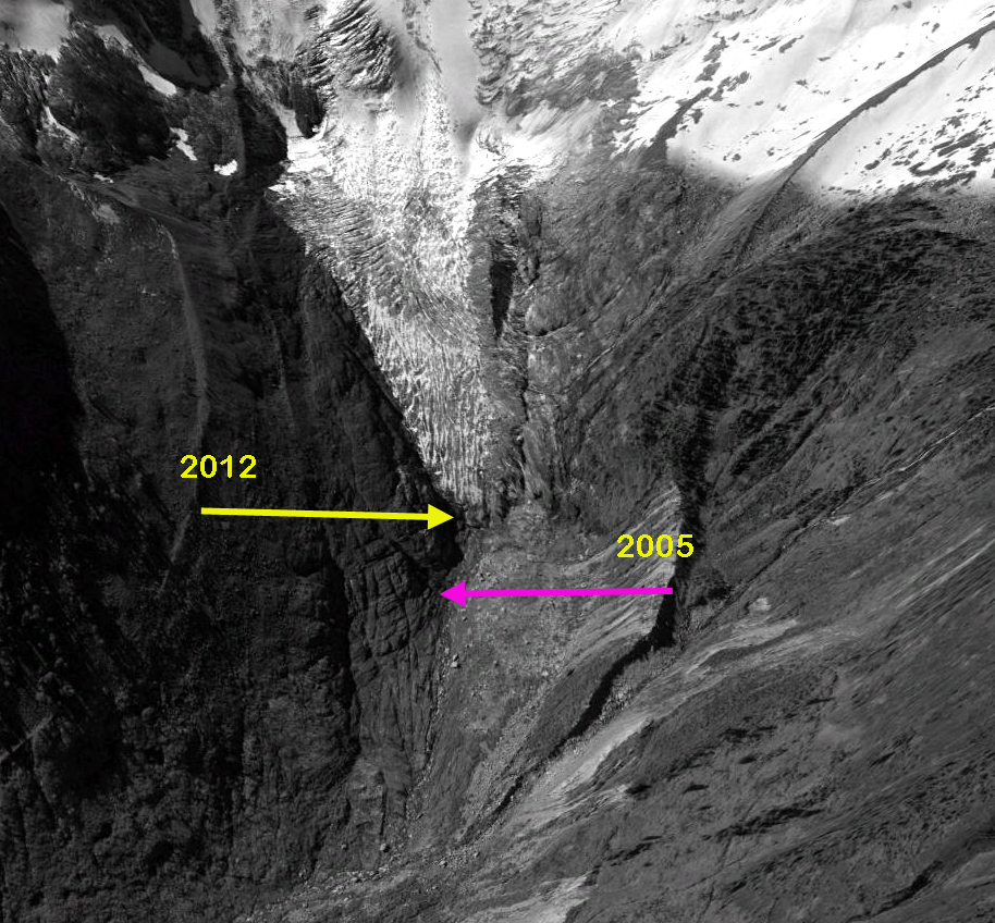
 A Google Earth image from 2005 of the terminus region indicates that the lower 700 meters of the current glacier is thin and lacks any crevasses indicating it nearly stagnant. By 2012 the terminus had retreated 80-90 m from 2005, yellow arrow indicates 2012 terminus, pink arrow 2005. This is in contrast to an active front, which indicates a healthy glacier, that would be thick and crevassed. A healthy glacier can still be retreating, the front was active at the time of my first visit to the glacier in 1984. The glacier is still 3.5 kilometers long and even after the retreat the glacier will still have a substantial length and area.
Minor Glacier-Wind River Range
Minor Glacier on Gannett Peak in the Wind River Range of Wyoming is truly minor compared to when its name was given. The glacier has retreated about 500 m since 1966, which was 35% of its total length. The east side of the glacier is nearly gone. The area has been reduced from 0.87 to 0.26 km2 in the last 50 years. 
 That is after a slow 12% loss in area from its Little Ice Age Maximum to 1952. A comparison of the 1966 map of the glacier and a 2006 SPOT satellite image illustrates the change. The glacier map outline is in orange on the satellite image. The glacier is quite thin and despite the steep slope has few crevasses evident in the image below. There is a substantial new lake that has formed at the terminus of the glacier since the 1966 map, which indicates no lake existed.
  bottom image From Peter Bakwin.
Milk Lake Glacier Loss, North Cascades, Washington
In the USGS map for Glacier Peak in the North Cascades, Washington based on 1979 aerial photographs, Milk Lake Glacier fills most of the Milk Lake Basin, with just a fringe of water seen. The glacier had an area of 0.24 square kilometers at this time.  The flat topography over the lake indicates a very thin unstable glacier area. In 1967 the lake has begun to form, Austin Post, USGS image and a few bergs are evident. By 1988, Milk Lake had formed, a notably circular new alpine lake, the former glacier ice still filled part of the lake as ice bergs. In visiting the glacier in 1988 I was surprised at the expansion of this formally small lake. The glacier had retreated to the margins of the lake fringing the west side of the lake. The fringing ice was clearly thin, we found several crevasses that reached bedrock 5-10 m down. In 1994 on a return visit in miserable weather, there was no longer any icebergs in the lake and the lake was more of a jade to turquoise color. The fringing ice had lost about half of its area since 1988. This glacier remnant was not going to last long.
 By 2006 the glacier was gone entirely even the fringing elements. One less glacier, one more alpine lake.
 And in 2009 it is clear that Milk Lake would not be the correct name any longer, not a scrap of ice in sight this past summer.
Zemu Glacier, Sikkim Thinning and Retreat
Zemu Glacier is a 26 km long glacier draining the east side of Kanchenjunga the world’s third highest mountain. The importance of the glacier is that it is a key water source for the Teetsa River. The glacier acts as a natural reservoir releasing water due to melting. The Teetsa River is the focus of a hydropower development project being undertaken by the Government of Sikkim. To date 510 mw of the proposed 3500 mw potential are operating. This is a run of the river project, with the water extracted from the river without a dam, run along the valley wall and dropped back to the river through a series of turbines. Run of river is much less expensive than a dam in this remote, earthquake prone, mountainous valley. Zemu Glacier has received little attention, and hence we will have to rely on Digital Globe imagery to observe its changes. The glacier has been observed to retreat at 27 m per year from 1967-1984. Given the length of the glacier the retreat was fairly slow. The glacier has a heavy debris cover on most of its length, insulating it from ablation, and leading to know detectable retreat of the main terminus from 2000 to 2013 Basnett et al (2013). A view of the lower glacier indicates this heavy debris cover, with some scattered small glacial lakes on its surface.

The newly devegetated zone beyond retreating glaciers is small, indicating the slow retreat. Thinning has been significant. The lateral moraine ridges on either side of the main glacier average 150 feet above the main glacier surface. These were built during the Little Ice Age advance. Lateral moraines do not reach above the glacier surface that built them. Thus, the lower glacier has thinned by approximately 150 feet in the last century or so.
A view of a portion of the upper glacier indicates one issue for the glacier. 
 Several of the tributaries no longer join the Zemu, depriving it of a portion of a portion of its former accumulation sources. Near the head of the glacier the walls of Kanchenjunga delivers the debris and large amounts of snow in the form of avalanches to the glacier basin at 5900 to 5200 m. The lower 18 km of the glacier is in the ablation zone where melt dominates. A comparison of 2000 and 2013 Landsat images indicates the lack of change in location of main terminus, red arrows, but recession of surrounding glaciers in the Zemu Basin, yellow arrows.

Landsat 2000
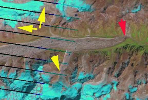
Landsat 2013
This area from 5200 m to the 4200 m terminus would quickly melt away without the natural debris cover. The glacier receives considerable snow input from up to 8000 m via avalanches, which are deposited in this region between 5200 m and 5900 m. This glacier will continue to be a large water source for the Teetsa River for the foreseeable future. The glacier has not been retreating as fast or developing a proglacial lake as has happened to Southh Lhonak Glacier, Middle Lhonak Glacier and Changsang Glacier to the north, this should be anticipated in the near future.
Dramatic Retreat of Antler Glacier, Alaska

Above is a pair of Landsat images from 1984 and 2013 indicating the 2600 m retreat of Antler Glacier in that period. Below is a detailed analysis of the glacier.
The Antler Glacier is an outlet glacier of the Juneau Icefield. It is actually a distributary glacier of the Bucher Glacier. It splits from the Bucher Glacier 8.5 km above where the Bucher Glacier joins the Gilkey Glacer as a tributary. In 1948 it spilled over the lip of the Antler River valley from the Bucher Glacier and flowed 6 kilometers downvalley to end in a proglacial lake. The glacier was 6200 m long in 1948. Note the comparison of the USGS map based on 1948 photographs and the 2005 satellite image below. 
 My only chance to see this glacier in person was in August, 1981 scouting the geology along the Bucher Glacier. Antler Glacier disappeared downvalley into the fog and light snow flurries. The terminus not in site, and icefall to daunting to wish to descend. By 2005 the glacier has retreated almost to the lip of the valley, a 5400 m retreat which is 85-90% of it total length. The Lake -Antler Lake- has expanded from a length of 1.6 km to 4.2 km. The lake is a gorgeous sight, and the valley once filled by the glacier is now nearly devoid of glacier input.
  The retreat is largely a result of reduced flow from the thinning Bucher Glacier which no longer spills over the valley lip significantly. As the Bucher Glacier continues to thin, the Antler Glacier will cease to exist. This thinning is due to increased melting (ablation) of the glacier. The neighboring glaciers Field and Gilkey Glacier have also thinned and retreated considerably.
Peridido Glacier Retreat
The Peridido Glacier, Pyrenees Mountains, Spain has lost 92% of its area since 1894. The glacier lost 50% of its area declining from 90 hectares to 44 hectares from 1991 to 2001. Pyrenees Glacier report, written by a group of scientists including Enrique Serrano from the Universidad de Valladolid and Eduardo Martínez de Pisón from the Autónoma de Madrid has noted the loss of 50-60% of the entire area of Pyrenees Glaciers since 1990. The images of Peridido Glacier from 1898 and 1910 were provided by Eduardo Blanchard. In 1910 as seen in the picture below right, the glacier has three sections each connected. The upper section connected with the mid section by a narrow crevassed icefall, the crevasses indicate active movement. The middle section is connected to the lower avalanche fed section by a wide crevassed icefall. The lower section is not heavily crevassed and has thinned and pulled back from the terminus moraine of the Little Ice Age. This moraine is the sediment ridge in the foreground. By 1998 there is no connection between the three sections, the lower section is nearly gone, with just a bit or relict ice. There are very few crevasses indicating a lack of active movement. The glacier is melting more or less in place. The Pyrenees have experienced a 0.9 C degree warming since 1910.

Peridido Glacier is rapidly disappearing, at the current rate of area loss it cannot survive to 2050, and more likely not until 2030. It is not alone in the Pyrenees, at least three glaciers have disappeared in the last 15 years, Balaitus, La Munia and Perdigurero.
Lyman Glacier a Century of Change-Years Numbered
This blog will focus glacier by glacier on the changes that are resulting from climate changes. Each has a unique story, yet there will be a recognizable refrain. Lyman Glacier, North Cascades, Washington retreated 1300 m from 1907 to 2008. Below is the glacier viewed from near Cloudy Pass in 1921 on a Mountaineers expedition and in 2005.


This 76% loss in length has been accompanied by a 88% loss in area and a 91% loss in glacier volume. I first visited the glacier in 1985, and have since been to the glacier on 15 occasions, twice with Bill Long, who first visited the glacier in 1940, measuring its terminus position then. The glacier currently ends in a beautiful expanding glacier lake, with an impressive ice cliff that is 40 meters high, 26 meters above the water. This aids in the retreat as the glacier does calve icebergs occassionally. The rate of retreat is 11 meters per year, for a glacier that is 440 m long, this gives the glacier 40 years at the current retreat rate. The glacier is losing area at a rate of 4% per year, giving it 25 years to survive. Volume loss is between 4 and 5% per year, giving the glacier 20-25 years to survive. By any measure with current climate Lyman Glacier will not survive to 2050. For this glacier the warmer summers since 1977 and the reduced snowpack due to more winter rain events has hastened its decline. The glacier is near a snow measurement station of the US Dept. of Agriculture, which indicates an 18% decline in mean April 1 snowpack since 1945, despite a small rise in precipitation. The glacier is no longer large, but still has considerable thickness, up to 50 m. This particular glacier has not approached equilibrium since the end of the Little Ice Age. Its loss has been hurried along by the recent warming. Even small glaciers take a long time to fully melt away.[url=http://www.youtube.com/watch?v=SiJzgiKReZI]

