
The Khumbu Glacier is a large debris-covered glacier in the Khumbu region. It is one of the more famous and often visited Himalayan glaciers as it is the key route for climbing Mount Everest. About 12 km long, it drains mainly from the West Cwm between Mt. Everest and Lhotse and ranges in altitude from over 8000 meters to 4900 m. The equilibrium line separating the region where snow typically persists through the year is 5600 m. Melting is very limited above 5800 m. The famed Khumbu Icefall transitions the glacier from the accumulation zone to the ablation zone. The ablation zone is where melting dominates. Base camp for climbing expeditions is on a debris covered portion of the glacier below the Khumbu Icefall, Pumori Lake is about one mile away. The debris cover is brought down by avalanches and exposed at the surface via melting. In the lower picture it is evident that the lower 10 km of the glacier is dominantly debris covered. 
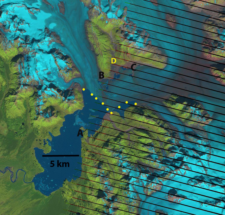
 The Kathmandu-based mountain research institute, ICIMOD, reports that the Khumbu Glacier is retreating at an average of 20m per year. The length of the glacier has shrunk from 12,040m in the 1960s to 11,100m in 2001. This 1 kilometer retreat has been consistently between 15 and 20 m per year during this interval. This retreat is less than nearby Ngozumpa Glacier and Imja Glacier. Everest Base Camp has actually dropped from 5,320m to 5,280m since Hillary and Tenzing first set up camp there more than fifty years ago. This 40 m of thinning at the base camp has occurred over this 55 year period. Base camp is on the right side of the glacier in this view notice the small colored blotches.
Measurements of velocity on the glacier by Nakawao and others (1999) noted that the Khumbu Glacier near the climbing base camp slowed by 10% between 1958 measurements and 1995 measurements. Kadota and others (2000) surveyed the Khumbu glacier in 1995 and compared the results with those of the 1978 survey. They found that the surface of the glacier lowered about 12-15 meters over most of the length but by only 6-8 meters near the terminus. A recent paper by Bolch et al (2008) compared a Corona DTM 1962 image and the ASTER DTM 2002 of Khumbu, Glacier. During this interval the Khumbu Glacier thinned in the ablation zone by an average of 17 m, This is a rate of 0.4 m/year.
Bolch et al. (2008).
Thinning at base camp of 40 meters is greater than at the terminus. The result is a reduced glacier slope. Reduced slope and thickness both lead to deceleration. The reduced thickness loss at the terminus is due to the debris cover thickness increasing towards the terminus. The same story is playing out on the Satopanth Glacier(Image from Jeff Engels)  Takeuchi and others (2000) noted that for Khumbu Glacier debris cover less than 5 cm increases ablation, debris greater than 5 cm in thickness reduces ablation. On Khumbu Glacier their ablation measurements indicate that ablation is reduced 40% from that of clean ice when the debris cover is 10 cm thick. Thicker debris cover reduced ablation even more, but only slightly. This is the primary reason why thinning has been less near the terminus.
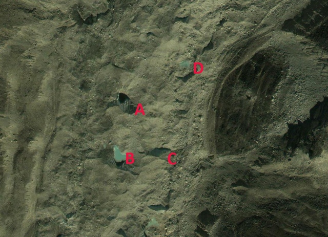
Naito et al. (2000) developed a model coupling mass balance and flow dynamics of debris covered glaciers and applied it to the Khumbu Glacier. The model predicts formation and enlargement of a depression in the lower ablation area about 5 km upstream of the terminus. This depression could transform into a glacier lake in future. Given the more rapid melting upglacier of the terminus and the low surface slope of this glacier, this is a reasonable result. The movement of the glacier can be tracked by examining the movement of supraglacial lakes downglacier. Below is 4 lakes denoted in a 2003 and 2009 image, the mean movement has been 120 m, 20 meters/year. 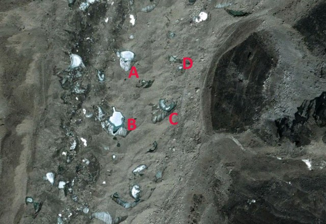
Given the slow rate of retreat and the 3000 m of altitude range above the current snowline the Khumbu Glacier is not in danger of disappearing with current climate. The entire Western Cwm the flat cirque seen beneath Nuptse, Lhotse and Everest here is in the permanent snow zone above 6000 m. The icefall then descends to 5400 m. The terminus is at 4900 m. It is not difficult to imagine this lower section of the glacier below the icefall wasting away. It is likely that a substantial proglacial will develop as is occurring at Ngozumpa Glacier and has occurred at Imja Glacier. 

Kadota, T., K. Seko, T. Aoki, S. Iwata, and S. Yamaguchi. 2000.
Shrinkage of the Khumbu Glacier, east Nepal from 1978 to
1995. IAHS Publ. 264 (Symposium at Seattle 2000 – Debris-
Covered Glaciers), 235–243.
Naito, N., M. Nakawo, T. Kadota and C.F. Raymond. 2000.
Numerical simulation of recent shrinkage of Khumbu Glacier,
Nepal Himalayas. IAHS Publ. 264 (Symposium at Seattle 2000 –
Debris-Covered Glaciers), 245–254.
Nakawo, M., H. Yabuki and A. Sakai. 1999. Characteristics of
Khumbu Glacier, Nepal Himalaya: recent changes in the debriscovered
area. Ann. Glaciol., 28, 118–122.


 This topography acts to slow and buttress the glacier. This area is above the topographic rise from the deep basin to the higher terrain of the current grounding line. The ongoing focus on the


 The glacier has retreated 1100 m between
 The retreat is ongoing. Medial moraines are bands of debris on the surface of a glacier that separate tributaries of a glacier. The moraines represent material eroded from the edge of the tributaries before they join. This material does not appear at the surface until you reach the ablation zone where melting dominates. In the accumulation zone such debris bands would be buried. On East Taklanika Glacier the debris bands extend to within 1 kilometer of the head of the glacier. For a glacier to be in equilibrium a glacier needs to have at least 50 % of its area in the accumulation zone at the end of the summer. Based on the satellite image hear showing 10% of its area in the accumulation zone and the extent of the medial moraine indicating no more than 25% of the glacier area above the moraine. This glacier needs to lose the lower 2-3 kilometers to be in equilibrium. This may not be enough. A glance at the glaciers around East Taklanika, indicate the same story, very little retained snowpack. Some of these glaciers have an accumulation area ratio (% of glacier snow covered at the end of the summer), of zero. This is like having no income, and plenty of expenditures and the result for your bank account, net loss and without some change eventual bankruptcy. The story of retreat is the same though the snowpack extent greater on the

 All three of these glaciers drain from the Juneau Iceifeld accumulation zone between 1500 and 2000 m, which maintain consistent snow cover. From 1948 to 1967 the Gilkey Glacier retreated 600 m and in 1961 a proglacial lake began to form. By 2005 Gilkey Glacier had retreated another 3200 m , generating a proglacial lake that is now 3.9 kilometers long, which is approximately the amount of retreat in the last 60 years as well.
  The lake is partly filled with large icebergs from disintegration of the, note below in an image from Scott McGee of JIRP,

") Easton Glacier extends from the terminus at 5600 feet to the slopes near Sherman Crater at 9000 feet. Each summer since 1990 NCGCP has measured the mass balance of this glacier. View
Easton Glacier extends from the terminus at 5600 feet to the slopes near Sherman Crater at 9000 feet. Each summer since 1990 NCGCP has measured the mass balance of this glacier. View 


 Marginal recession averages 95 meters in this period ranging from 20-200 meters. The glacier was 1200 meters long in 1990 so this is close to a 10% loss in length. The current rate of retreat is slightly higher than the 3-5 m/a average fro the 1979-1993 period. The image in 1991 is from Aug. 25th, the glacier still has 70% of its area covered with snow from the previous winter. This is called the accumulation area ratio and in general must be above 60 at the end of the summer for the glacier to not lose mass. In 2003 the accumulation area ratio is about 30 and this is on Sept. 25th at the end of the melt season. In 2005 the accumulation area ratio is 30 at the most. Both years this limited a snowcover would lead to a significant negative mass balance, volume loss. The thinning in the upper portion of the glacier appears limited. There is not an evident change in the upper margin of the glacier. The crevassing which is indicative of movement has also not decreased much suggesting limited changes in the dynamics of the upper glacier. The comparatively slow changes in the accumulation zone, suggests a glacier that still has a consistent accumulation zone and is not likely to melt away rapidly, within the next 30 years, given the current climate. The glacier is showing no signs that it is approaching equilibrium, and that it can survive the current climate. This is in contrast to nearby


 The snow produced here can be channeled directly onto the slopes below by the Gletschersee chair lift. The water for this innovative snow production system will be extracted using a vacuum system from the existing storage pools on the Pitztal Glacier. These pools are filled exclusively with melted glacier water, thus forming an ecological cycle on the glacier, returning its own meltwater as snow. After gaining experience, concrete attempts will be made to use the snow created by the Snowmaker to preserve the substance of the glacier in Austria’s highest glacier ski area. The glacier seen below has in most years been bare by late summer, not a skiable condition. The net volume loss of the glacier has also been notable.


 Despite the advantages of snow accumulation the glaciers mass balance since 1984 has average -0.5 m a year for a cumulative loss of 13 m. For a glacier that averages 60 m in thickness this is over 20% of its volume. Details of the