
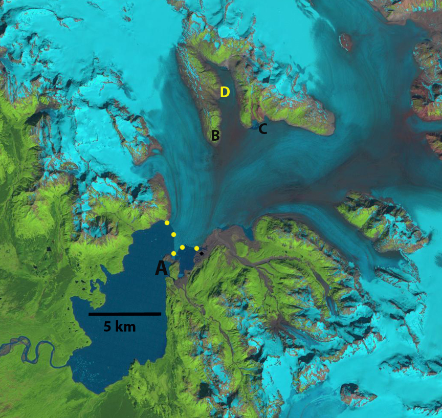
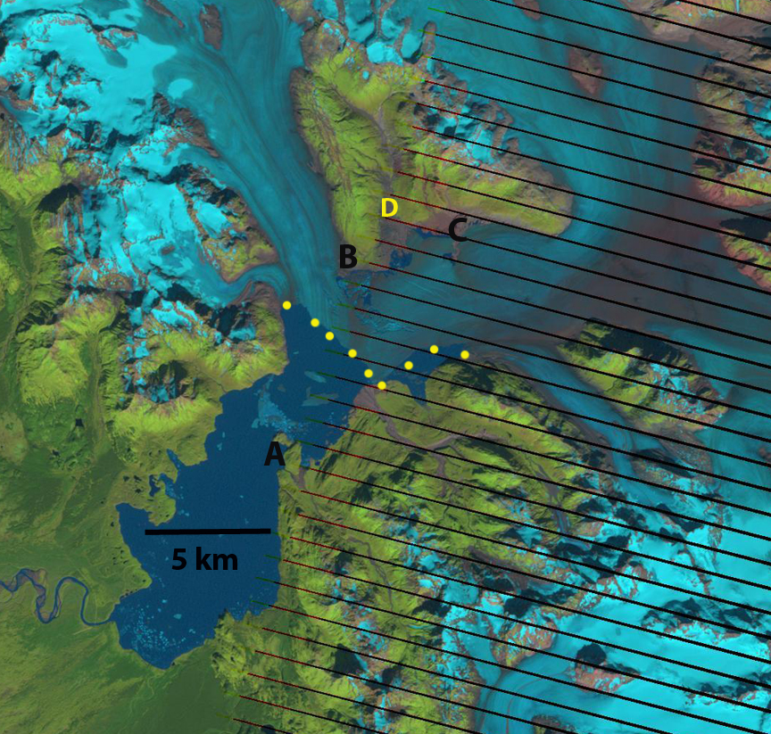
The Yakutat Glacier during the 1894-1895 Alaskan Boundary Survey ended near a terminal moraine on a flat coastal outwash plain. By 1906 the glacier had retreated from the moraine and a new lake was forming. Harlequin Lake. Surveys of the terminus of the glacier indicated a retreat of 1 kilometer in that decade. From 1906-1948 the glacier retreated an additional 5 km. From 1948-1958 the glacier retreated 3.6 km. The retreat is evident in comparing the Yakutat B-3 quadrangle, from 1958 photography, and Landsat imagery from 1984, 2010 and 2013. Points A-D are the same in each image and the yellow dots are the terminus. In 1984 the terminus was just retreating from a peninsula marked A, the valley at D was filled with ice, there was no break in the surface at C and B was well inland of the terminus. By 2010 the glacier had retreated from A, the valley at D was deglaciated, a small strip of bedrock-sediment was exposed at C from what had been beneath the glacier, and B was still well inland of the terminus. By 2013 the northern arm of the glacier had retreated 6.4 km from the peninsula at A toward the peninsula at B. The central arm of the glacier toward C had retreated 7.5 km and the retreat on the southern edge of the glacier was 6.5 km. The glacier had retreated on average more than 6.6 km in 30 years, a rate of 220 m/year. The retreat was most rapid from 2010-2013, when the glacier retreated 3 km.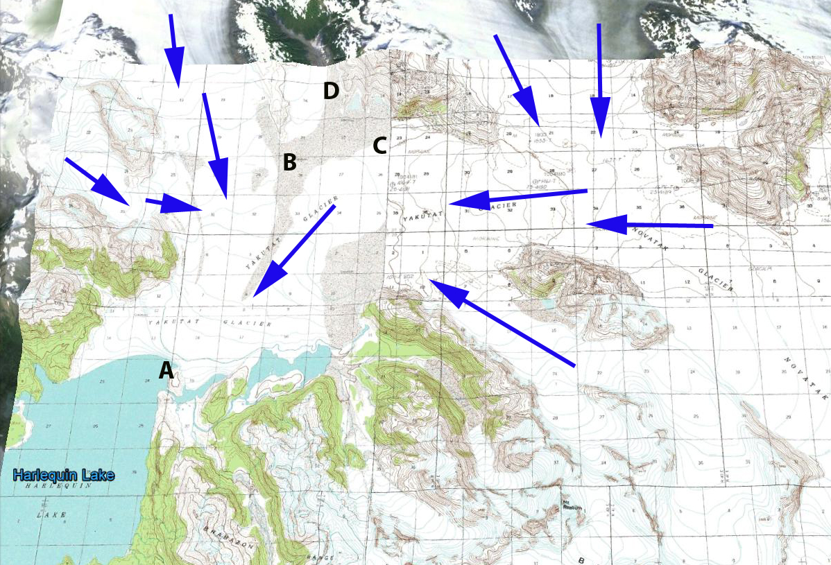
Yakutat terminus map
1987 Landsat image
 2010 Landsat image

2013 Landsat image.
Today the glacier is the focus of a study by the University of Alaska, led my Roman Motyka, Martin Truffer and Chris Larsen
They have set up a time lapse camera to record frontal changes. The goal is to understand the controls on calving into Harlequin Lake of this glacier. More amazing than the retreat has been the observed thinning of the glacier. The glacier has thinned by more 200 m on average according to the preliminary thickness change maps from the UAF project (Truessel et al 2013). The Yakutat Glacier does not have a high accumulation zone and the recent increase in the snowline elevation and thinning of the glacier have led to a substantial shrinking of the accumulation zone and thinning of the glacier in the accumulation (Truessel et al 2013). This glacier does not have a persistent significant accumulation zone and cannot survive (Pelto, 2010). For a calving glacier to be in equilibrium it needs to have at least 60 % of its area snowcovered at the end of the summer. The glacier is in the midst of a large ongoing retreat. The retreat rate and calving mechanism is similar to that of Grand Plateau Glacier, Bear Lake Glacier and Gilkey Glacier. However, unlike these Yakutat Glacier lacks an accumulation zone, a better analog is East Novatak Glacier, which also has a lower elevation accumulation zone. 


 This topography acts to slow and buttress the glacier. This area is above the topographic rise from the deep basin to the higher terrain of the current grounding line. The ongoing focus on the


 The glacier has retreated 1100 m between
 The retreat is ongoing. Medial moraines are bands of debris on the surface of a glacier that separate tributaries of a glacier. The moraines represent material eroded from the edge of the tributaries before they join. This material does not appear at the surface until you reach the ablation zone where melting dominates. In the accumulation zone such debris bands would be buried. On East Taklanika Glacier the debris bands extend to within 1 kilometer of the head of the glacier. For a glacier to be in equilibrium a glacier needs to have at least 50 % of its area in the accumulation zone at the end of the summer. Based on the satellite image hear showing 10% of its area in the accumulation zone and the extent of the medial moraine indicating no more than 25% of the glacier area above the moraine. This glacier needs to lose the lower 2-3 kilometers to be in equilibrium. This may not be enough. A glance at the glaciers around East Taklanika, indicate the same story, very little retained snowpack. Some of these glaciers have an accumulation area ratio (% of glacier snow covered at the end of the summer), of zero. This is like having no income, and plenty of expenditures and the result for your bank account, net loss and without some change eventual bankruptcy. The story of retreat is the same though the snowpack extent greater on the

 All three of these glaciers drain from the Juneau Iceifeld accumulation zone between 1500 and 2000 m, which maintain consistent snow cover. From 1948 to 1967 the Gilkey Glacier retreated 600 m and in 1961 a proglacial lake began to form. By 2005 Gilkey Glacier had retreated another 3200 m , generating a proglacial lake that is now 3.9 kilometers long, which is approximately the amount of retreat in the last 60 years as well.
  The lake is partly filled with large icebergs from disintegration of the, note below in an image from Scott McGee of JIRP,

") Easton Glacier extends from the terminus at 5600 feet to the slopes near Sherman Crater at 9000 feet. Each summer since 1990 NCGCP has measured the mass balance of this glacier. View
Easton Glacier extends from the terminus at 5600 feet to the slopes near Sherman Crater at 9000 feet. Each summer since 1990 NCGCP has measured the mass balance of this glacier. View 


 Marginal recession averages 95 meters in this period ranging from 20-200 meters. The glacier was 1200 meters long in 1990 so this is close to a 10% loss in length. The current rate of retreat is slightly higher than the 3-5 m/a average fro the 1979-1993 period. The image in 1991 is from Aug. 25th, the glacier still has 70% of its area covered with snow from the previous winter. This is called the accumulation area ratio and in general must be above 60 at the end of the summer for the glacier to not lose mass. In 2003 the accumulation area ratio is about 30 and this is on Sept. 25th at the end of the melt season. In 2005 the accumulation area ratio is 30 at the most. Both years this limited a snowcover would lead to a significant negative mass balance, volume loss. The thinning in the upper portion of the glacier appears limited. There is not an evident change in the upper margin of the glacier. The crevassing which is indicative of movement has also not decreased much suggesting limited changes in the dynamics of the upper glacier. The comparatively slow changes in the accumulation zone, suggests a glacier that still has a consistent accumulation zone and is not likely to melt away rapidly, within the next 30 years, given the current climate. The glacier is showing no signs that it is approaching equilibrium, and that it can survive the current climate. This is in contrast to nearby


 The snow produced here can be channeled directly onto the slopes below by the Gletschersee chair lift. The water for this innovative snow production system will be extracted using a vacuum system from the existing storage pools on the Pitztal Glacier. These pools are filled exclusively with melted glacier water, thus forming an ecological cycle on the glacier, returning its own meltwater as snow. After gaining experience, concrete attempts will be made to use the snow created by the Snowmaker to preserve the substance of the glacier in Austria’s highest glacier ski area. The glacier seen below has in most years been bare by late summer, not a skiable condition. The net volume loss of the glacier has also been notable.


 Despite the advantages of snow accumulation the glaciers mass balance since 1984 has average -0.5 m a year for a cumulative loss of 13 m. For a glacier that averages 60 m in thickness this is over 20% of its volume. Details of the
 The Belcher Glacier above is the principal outlet glacier calving up to 30% of the total iceberg volume from the ice cap.
 In this case the mass balance record indicates a dramatic worsening after 1995. It will be interesting to see the ablation results from the summer of 2008, when record melting was noted both in northern Greenland and northern Ellesmere Island. The glacier is not alone in its behavior, the Prince of Wales Icefield has had a negative mass balance over the last forty years of -80 km3, equivalent to a mean-specific mass balance across the ice field of -0.1 m w.e. a-1, contributes 0.20 mm to global eustatic sea level rise (