
The Brooks Range of Alaska contains many alpine glaciers. You hear little about them as there are no large ones and none that can be seen from a cruise ship as in southern Alaska. Though I have worked on many Alaskan glaciers for extended periods, it has always been in southeast Alaska on the larger Juneau Icefield. Hey one month until my 30th field season. The climate is much different as well, with the Arctic Ocean instead of the Pacific Ocean having a more dominant role. The Beaufort Sea Gyre is the nearest major ocean current feature. The Okpilak Glacier drains into the Arctic Ocean and is a large glacier by Brooks Range standards. Matt Nolan at the University of Alaska-Fairbanks has done a beautiful of duplicating a picture taken by Ernest Leffingwell in 1906 with pictures he has taken in 1994, 2004 and 2007. Below is the 1906 picture and the 1994 image, and the 2006 Google Earth view of the glacier. The large retreat is evident, the lateral moraine from the Little Ice Age today stands high above the glacier on the mountain side.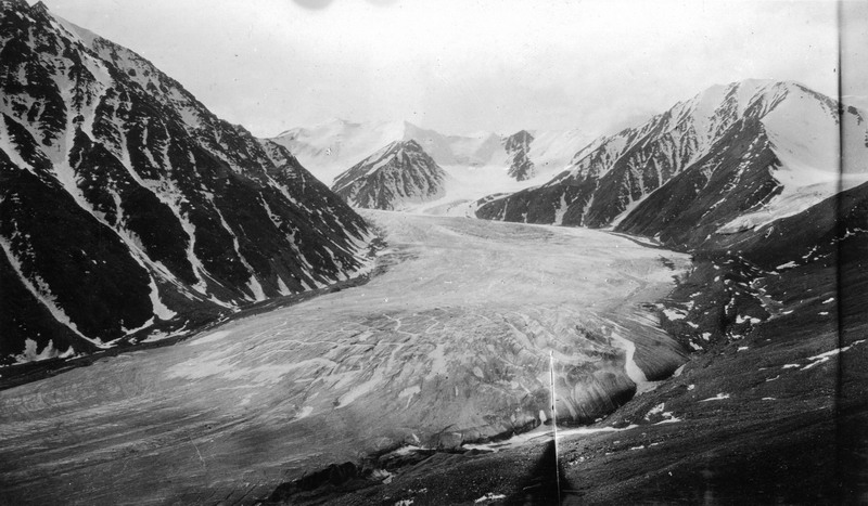

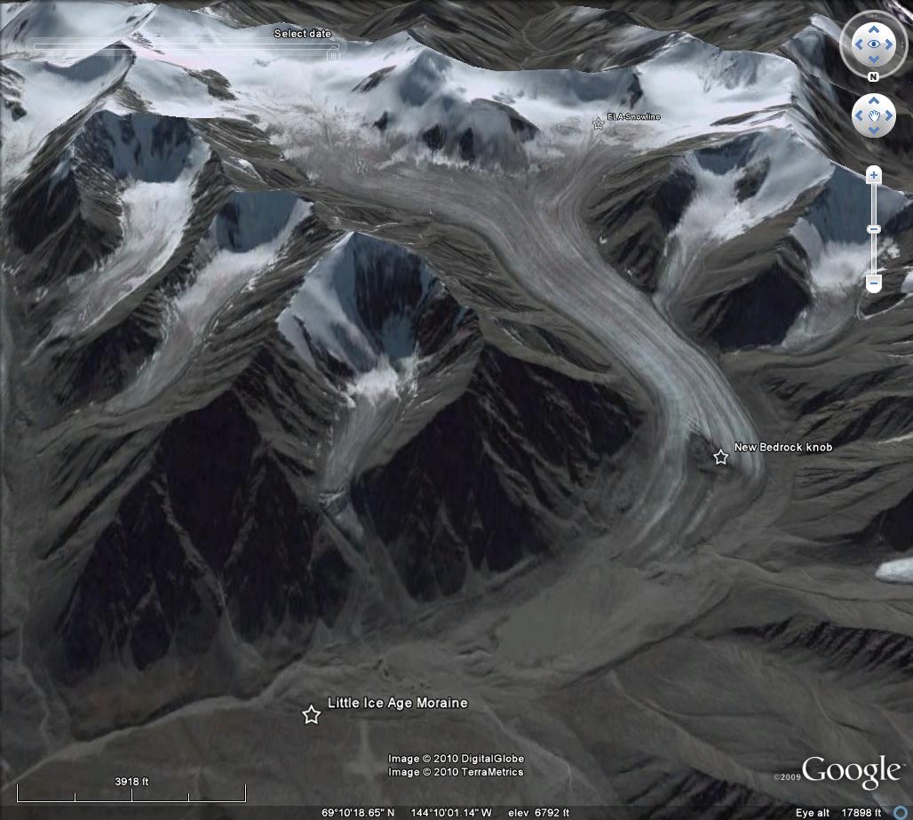 The glacier was still near its Little Ice Age maximum when Leffingwell took his picture. By 2006 the glacier had retreated just over 2 kilometers, note the Little Ice age moraine in the Okpilak Glacier image from Google Earth. There is a bedrock knob apparent in both the 1994 and 2006 image, though the ice thickness around the knob is much reduced by 2006. Also the lake at the end of the glacier in 1994 is quickly filling in with glacier sediment and by 2006 is not as prominent. Bernhard Rabus and Keith Echelmeyer-Univ. Alaska-Fairbanks had reported in 1998 that this glacier had retreated 420 meters between 1973 and 1993, 5% of its length and a rate of 20 meters per year. This is larger than the rate of 6-7 meters per year from 1907 and 1958 reported by Ed Sable, who photographed and surveyed the glacier in 1958. The rate of retreat has remained rapid. The 2006 image illustrates the problem, the ELA-snowline is too high and leaves only a small percentage of the glacier snowcovered at the end of the summer. This has been the pattern in recent decades and has led to a loss in average thickness of 30-40 cm per year. This loss though it is in a different climate region is remarkably similar to the losses observed on Lemon Creek Glacier. A view of the terminus of the glacier in 2006 from Google Earth indicates a bedrock knob that is 800 meters upglacier of the terminus.
 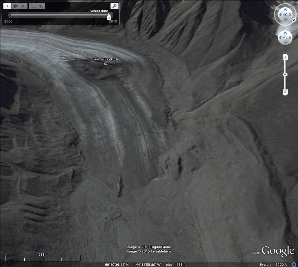 Below this knob there is little crevassing, the ice is thin, both suggesting stagnation and that this section of the glacier will soon be lost. As the sea ice to the north diminishes this area will be interesting to observe, as the potential is there for increased snowfall, while the open water will clearly lead to more warming as well.
Tag: alaska glacier retreat
Brady Glacier, Alaska begins a substantial retreat
Brady Glacier is a large glacier at the south end of the Glacier Bay region, Alaska. When first seen by George Vancouver it was a calving tidewater glacier in 1794 filling Taylor Bay with ice. Brady Glacier ceased calving and advanced approximately 8 km during the 19th century (Klotz, 1899). As Bengston (1962) notes, the advance is likely another example of an advance following a change from tidal to non-tidal status rather than that of a more positive mass balance. Bengston (1962) further notes that the massive outwash plain at the terminus is primarily responsible for Brady glacier maintaining itself well other glaciers in the Glacier Bay region retreat. The ELA on this glacier is 800 m, the line above which snow persists even at the end of the average summer, this is one of the lowest in Alaska. The main terminus was still advancing in the 1960’s and 1970’s and has managed a 250-300 meter advance since the USGS map of the 1950’s. The main terminus is not advancing any longer and has begun to retreat, the retreat to date is less than 200 meters. The image below is the 1950’s map of the glacier.  Brady Glacier is a complex glacier with many subsidiary termini. Echelmeyer, Arendt, Larsen and Harrison from the University of Alaska noted a thinning rate in the mid 1900’s of about 1 meter per year on the Brady Glacier complex. A comparison of 1950’s USGS maps and 2004-2006 satellite imagery indicate all six main subsidiary termini are retreating. The retreat ranges from 200 m in Abyss Lake, 200 m in Trick Lake to 1200 meters in North Deception Lake. The image below is the 2006 satellite image. Compare to the map, Deception has increased in size several fold. North Trick and South Trick Lake are now joined, Trick Lake.
 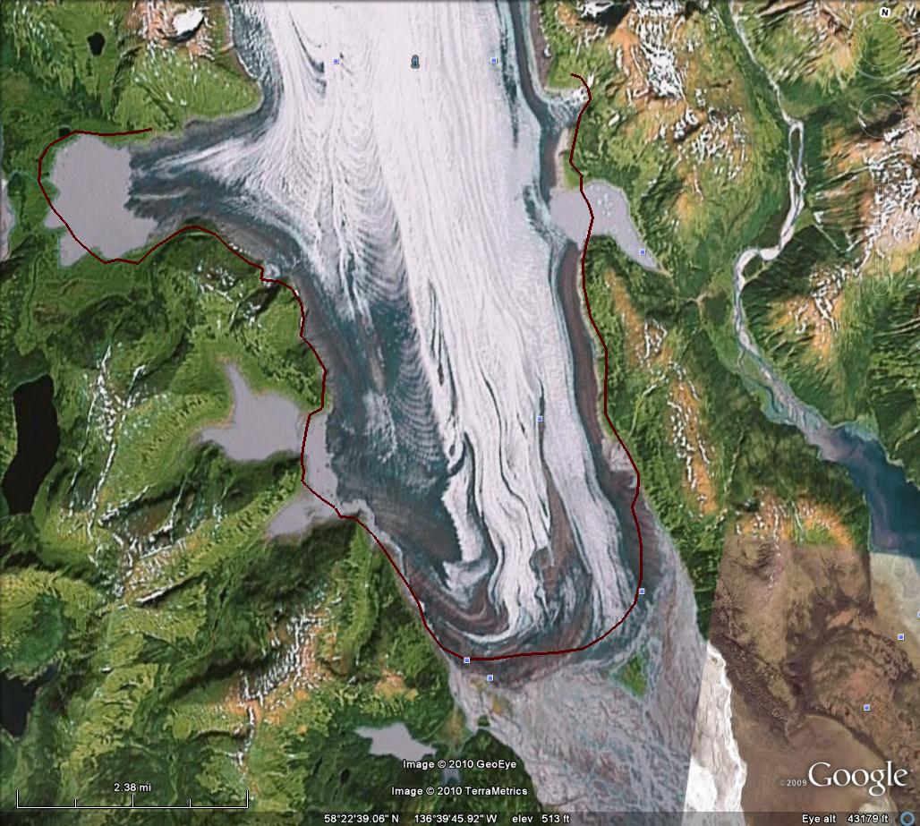 Of further interest is the stream draining Trick Lake that sneaks down the west margin of the glacier. This has enabled the water level in the glacier dammed Trick Lake to decline. Note the brown grey “Bath Ring” so to speak above the lake level. The outlet has also been marked in the image below. Pelto (1987) noted that the percentage of the glacier in the accumulation zone was right at the threshold for equilibrium. Subsequent warming of the climate in southeast Alaska and reduced glacier mass balance in the region has initiated this retreat.
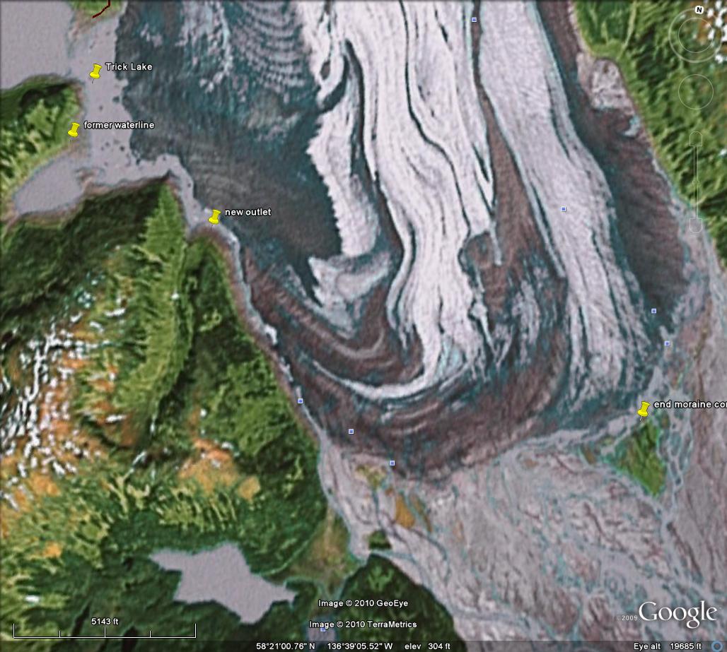 These termini are all closer to the equilibrium and would respond first to changes in mass balance due to recent warming and consequent measured thinning. This entire line of reasoning must be explored. The glacier is thinning substantially and would appear to be poised for a substantial retreat of the main termini, not just the subsidiary termini.
References not linked:
Bengston, K. recent behavior of Brady Glacier, Glacier Bay National Monument, Alaska. IAHS, 58, 59-77.
Klotz O. 1899: Notes on glaciers of southeast Alaska and adjoining territories. Journal of Geography, 14, 523-534.
Pelto, M. 1987. Mass balance of southeast Alaska and northwest British Columbia glaciers from 1976 to 1984: Methods and Results”. Annals of Glaciology 9: 189–193.
Dramatic Retreat of Antler Glacier, Alaska

Above is a pair of Landsat images from 1984 and 2013 indicating the 2600 m retreat of Antler Glacier in that period. Below is a detailed analysis of the glacier.
The Antler Glacier is an outlet glacier of the Juneau Icefield. It is actually a distributary glacier of the Bucher Glacier. It splits from the Bucher Glacier 8.5 km above where the Bucher Glacier joins the Gilkey Glacer as a tributary. In 1948 it spilled over the lip of the Antler River valley from the Bucher Glacier and flowed 6 kilometers downvalley to end in a proglacial lake. The glacier was 6200 m long in 1948. Note the comparison of the USGS map based on 1948 photographs and the 2005 satellite image below. 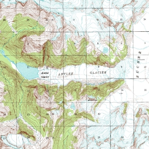
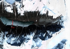 My only chance to see this glacier in person was in August, 1981 scouting the geology along the Bucher Glacier. Antler Glacier disappeared downvalley into the fog and light snow flurries. The terminus not in site, and icefall to daunting to wish to descend. By 2005 the glacier has retreated almost to the lip of the valley, a 5400 m retreat which is 85-90% of it total length. The Lake -Antler Lake- has expanded from a length of 1.6 km to 4.2 km. The lake is a gorgeous sight, and the valley once filled by the glacier is now nearly devoid of glacier input.
 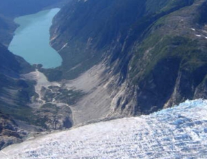 The retreat is largely a result of reduced flow from the thinning Bucher Glacier which no longer spills over the valley lip significantly. As the Bucher Glacier continues to thin, the Antler Glacier will cease to exist. This thinning is due to increased melting (ablation) of the glacier. The neighboring glaciers Field and Gilkey Glacier have also thinned and retreated considerably.

