Falcon Glacier, British Columbia Wings Clipped by Climate Change

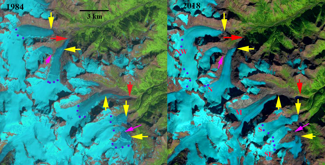
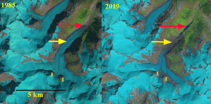
Falcon Glacier in 1985 and 2019 Landsat images indicating the 2000 m retreat.  Red arrow is 1985 terminus location, yellow arrow the 2019 terminus location. I=icefall locations joining the glacier.

Falcon Glacier in southwest British Columbia drains east from the Compton Neve into the Bishop River, which then joins the Southgate River. The Southgate River is one of three major watersheds emptying into the head of Bute Inlet. The Southgate River is known for the large runs of Chum Salmon. The area was the focus of a proposed Bute Inlet hydropower, that at present is no longer being pursued.  The region has experienced large negative mass balances 2000-2018 (Menounos et al 2018), that is driven retreat of many glaciers in the immediate area such as Bishop Glacier and Klippi Glacier.  Here we examined Landsat images from 1985 to 2019 to determine the response to climate change of Falcon Glacier.

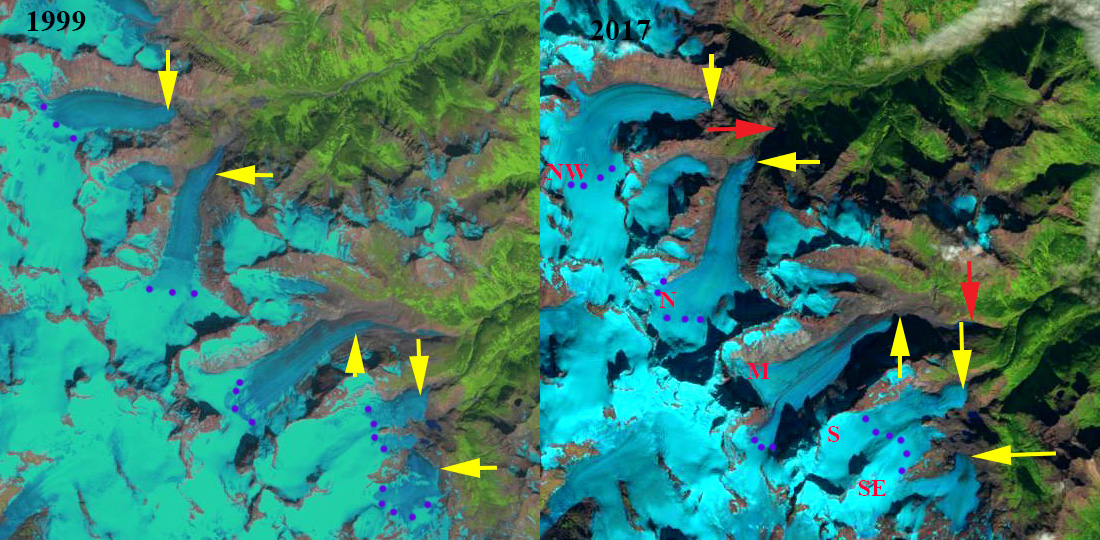
In 1985 Falcon Glacier terminated at 980 m and was over 10 km long (red arrow).  There were two icefalls (I) feeding the glacier along with the two principal tributaries.  By 2002 the glacier had retreated 800 m, with narrow ponding in front of the terminus.  The two icefalls were still active and the medial moraine extending to the terminus had increased prominence. By 2015 the glacier had retreated another 800 m and the two icefalls are barely connected to the main glacier.  The snowline is higher in 2015 at 1850 m.  By 2019 Falcon Glacier had retreated 2000 m, losing 20% of its length since 1985.  The eastern icefall no longer rejoins the main glacier.  The western icefall is barely connected.  The snowline in early August 2019 is already at 1850 m indicating a limited accumulation area again. The high snowlines and continued expansion of bedrock areas even at 2000 m indicates the glacier will continue its rapid retreat.

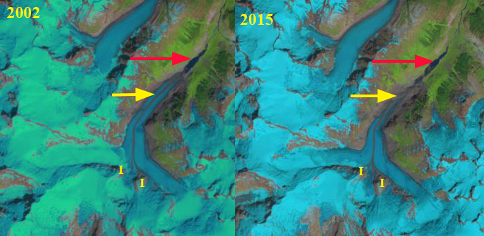
Falcon Glacier in 2002 and 2015 Landsat images indicating the 2000 m retreat.  Red arrow is 1985 terminus location, yellow arrow the 2019 terminus location. I=icefall locations joining the glacier.

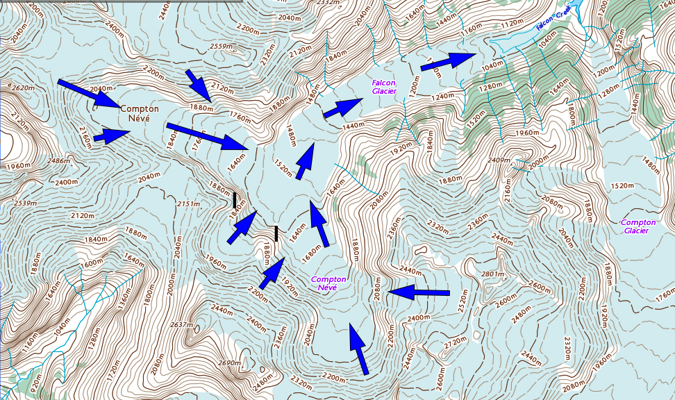
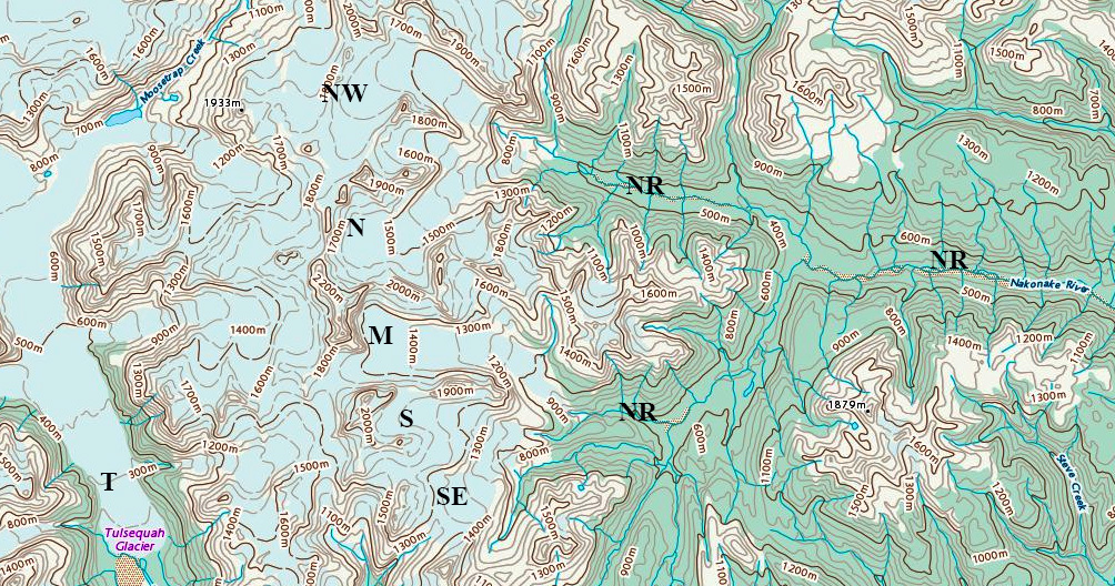
Map of Falcon Glacier indicating flow direction and icefalls (I). 

Nakonake Glaciers, BC Retreat Two are Disappearing

Nakonake Glaciers in 1984 and 2018 Landsat images. Nakonake Glaciers are NW=Northwest, N=North, M=Middle, S=South, SE=Southeast.  Red arrows indicate the 1984 terminus position of the North and Middle Nakonake Glaciers.  Yellow arrows indicate the 2018 terminus location of each. Purple dots indicate the snowline and the pink arrow indicates locations of glacier separation.

The Nakonake Glaciers are a group of unnamed glaciers at the headwaters of the Nakonake River in NW Britishc Columbia.  The range is just east of the Tulsequah Glacier-Juneau Icefield.  The Nakonake River flows into the Sloko River which joins the Taku River.  There are sockeye, coho and chinook salmon in the Sloko River.  The Sloko River below the junction with Nakonake River is known as a fun stretch of river to run. My only experience with this glacier group was watching a grizzly bear ascend from the lower Tulsequah Glacier into the Nakonake area. Menounos et al (2018) indicate this region of British Columbia had the largest mean annual mass balance losses from 2000-2018.

In 1984 the Norhtwest (NW) Nakonake terminated at the top of a steep slope at 1100 m.  North (N) Nakonake Glacier terminated at 800 m with a longer valley tongue than the NW glacier.  The Middle (M) Nakonake Glacier terminated at 900 m and had a substantial low slope terminus tongue. The South (S) Nakonak Glacier merged with the Southeast (SE) Nakonake Glacier at this time.  The snowline varied from 1500 m on NW to 1400 m on N and M and 1300 m on S and SE.  By 1999 the SE Nakonake Glacier had separated from the S Nakonake Glacier though it still had two terminus lobes that were connected. The snowline ranged from 1600 m on the NW Nakonake to 1400 m on the S and SE Nakonake. In 2017 the snowline was quite high ranging from 1700+ m on NW Nakonake to 1500+ m on South Nakonake Glacier.  In 2018 the Juneau Icefield regions saw the highest snowlines of the last 70 years (Pelto, 2018). The snowline was above the top of the M Nakonake and SE Nakonake Glacier. The snowline was above 1800 m on NW Nakonake and 1700 m on the S Nakonake Glacier. Retreat of the NW Nakonake from 1984-2018 was limited at 200 m, though recent high snowlines should accelerate this retreat.  The N Nakonake Glacier that had a low elevation terminus tongue still in 1984 and retreated 1400 m from 1984-2018.  The M Nakonake also had a low elevation tongue that melted away leading to  a retreat of 2200 m from 1984-2018. The retreat is 30+% of the glacier length lost.  This glacier lacks a significant accumulation and will not survive. The S Nakonake retreat like the NW was minor at ~200m.  The SE Nakonake Glacier was 700 m, which given a glacier length of just over 3 km is a substantial loss. This glacier lacks a significant accumulation zone and will not survive. This glacier has separated into two parts.

Tulsequah Glacier has experienced a more rapid retreat enhanced by proglacial lake development (Pelto, 2017).

Nakonake Glaciers in 1999 and 2017 Landsat images. Nakonake Glaciers are NW=Northwest, N=North, M=Middle, S=South, SE=Southeast.  Red arrows indicate the 1984 terminus position of the North and Middle Nakonake Glaciers.  Yellow arrows indicate the 2018 terminus location of each. Purple dots indicate the snowline.

Map of the Nakonake Glaciers and headwaters of the Nakonake River (NR). Tulsequah Glacier (T) to the west is also noted.

Beautiful British Columbia Land of Many Mountains & Dwindling Glaciers

[ngg_images source=”galleries” container_ids=”4″ display_type=”photocrati-nextgen_basic_imagebrowser” ajax_pagination=”1″ template=”/nas/wp/www/sites/blogsorg/wp-content/plugins/nextgen-gallery/products/photocrati_nextgen/modules/ngglegacy/view/imagebrowser-caption.php” order_by=”sortorder” order_direction=”ASC” returns=”included” maximum_entity_count=”500″]

British Columbia is host to many mountain ranges; Purcell, Monashee, Bugaboo, Selkirk, Cariboo, Coat Range, Kootenay, Kwadacha are just some of the diverse mountain ranges  that host glaciers and span climate zone. A shared characteristic today regardless of climate zone or mountain range is dwindling glacier size and volume.  Bolch et al (2010) found that from 1985-2005 Alberta glaciers lost 25% of their area and BC glaciers 11% of their area.  Tennant and Menounos (2012) examined changes of the Rocky Mountain glaciers including Alberta finding that between 1919 and 2006 glacier cover decreased by 590 square kilometers, 17 of 523 glaciers disappeared and 124 glaciers fragmented into multiple ice masses.  Jiskoot et al (2009) examined the behavior of glaciers of the Clemenceau and Chaba Icefield and found that from the mid 1980’s to 2001 the Clemenceau Icefield glaciers had lost 42 square kilometers, or 14% of their area. Pelto (2016) reported on specific retreat of many of these BC glaciers. Below are links to 31 detailed post examining the changes in recent decades of British Columbia glaciers in response to climate change.

In the summer glaciers in many ranges are crucial water resources for aquatic life and hydropower.   In BC 92% of electricity is generated by hydropower mainly from large projects.  BC Hydro has 31 such large projects, including several heavily fed by glaciers: Bridge River, Mica, Cheakamus, Ruskin and Stave Falls. There are also run of river hydroprojects with a new one constructed by AltaGas, the 195 MW Forrest Kerr Project on Tahltan First Nation land on the Iskut River. The Iskut River like the Stikine River is heavily glacier fed. As spring begins glaciologists will be heading out to measure glacier mass balance a critical input to understanding current and future glacier runoff, such as the Columbia Basin Trust sponsored project overseen by Brian Menounos at UNBC, and field operation direct by Ben Pelto at UNBC.


Forrest Kerr Hydro is a run of river project relying on a weir instead of a dam to divert water into the intake.
There are also numerous salmon fed streams with critical glacier input, such as the Skeena River and Rivers Inlet. Stahl and Moore (2006) identified that discharge from glacierized and nonglacierized basins in British Columbia indicates the negative August streamflow trends illustrate that the initial phase of increase runoff causing by climate warming has passed and runoff is now declining. This is similar to further south in the North Cascades of Washington (Pelto, 2015).

Shatter and Shudder Glacier
Snowcap Creek Glacier
Stave Glacier
Helm Glacier
Warren Glacier
Galaxy Glacier
Icemantle Glacier
Big Bend Glacier
Kokanee Glacier
Toby Glacier
Conrad Glacier
Vowell Glacier
Bridge Glacier
Klippi Glacier
Yoho Glacier
Des Poilus Galcier
Haworth Glaciers

Apex Glacier
Kiwa Glacier
Dismal Glacier
Cummins Glacier
Coleman Glacier
Swiftcurrent Glacier
Bromley Glacier
Sittakanay Glacier
Nass Peak Glacier
Porcupine Glacier
Great Glacier
Hoboe Glacie
Tulsequah Glacier
Melbern Glacier