Lekhziri Glacier, Georgia Retreat Leads to Separation 1996-2022

Lekhrziri Glacier in 1996 and 2022 Landsat images illustrating the retreat and separation of the three tributaries central (Lc), eastern (Le) and western (Lw). Red arrow indicates 1996 terminus and yellow arrows the 2022 terminus locations

Lekhrziri Glacier has been the largest glacier in Georgia, and was until 2011 a compound glacier comprised of three tributaries joining a short distance from the terminus (Tielidze et al 2016).  Tielidze et al (2015) observed in 2011 that the central tributary separated from the east and west tributary that year at the headwaters of  the Mestiachala River Basin. From 2000-2020 Lekhziri Glacier experienced the largest retreat, of 1395 m, of 16 large Caucasus glaciers examined by (Tielidze et al 2022). Here we examine Landsat and Sentinel imagery from 1996-2022 to illustrate the changing nature of this glacier.

In 1996 the three tributaries joined at 2300 m and then flowed jointly south for 1 km to the terminus, red arrow on Landsat image. The August snowline is at 3300 m. By 2013 the central glacier has visibly separated by 500 m from the other tributaries. The primary terminus has had a retreat of ~500 m since 1996. The August snowline is at 3400 m in 2013. In 2022 additional retreat as separated the east and west tributaries, with an evident river emanating from each tributary, yellow arrows, feeding into the Mestiachala River. The central tributary terminates 800 m from the former junction. The retreat of the east tributary has been 1.3 km since 1996 and the west tributary 1.25 km since 1996. There is also a small lake that is evident, green arrow, in 2022 that will fill in with sediment.  The snowline at the end of August 2022 is at 3450 m. The persistent high snowlines due to warm melt season conditions has led to ongoing mass loss that will lead to continued declines in the Lekhziri Glacier system. This is one example of the widespread retreat of glaciers in the region chronicled by Levan Tielidze. The high snowlines of 2017 and 2022 have been noted for Gora Gvandra glaciers and Zeno Svaneti glaciers.

Lekhrziri Glacier in 2013 Landsat image illustrating the retreat and separation of the three tributaries central (Lc), eastern (Le) and western (Lw). Red arrow indicates 2013 terminus and purple dots the snowline.

Lekhrziri Glacier in 2022 Sentinel image illustrating the retreat and separation of the three tributaries central (Lc), eastern (Le) and western (Lw). Yellow arrows the 2022 terminus locations aand green arrows the small lake at headwaters of Mestiachala River Basin.

Lednik Midagrabin Retreat, Caucasus, Russia

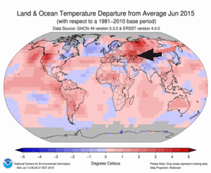
Lednik Midagrabin is a large glacier draining northwest from Gora Dzhimara in North Ossetia, Russia.  Stokes et al (2006)  examined Caucasus glaciers during the 1985-2000 period and found that 94% of the glaciers have retreated, 4% exhibited no overall change and 2% advanced. The mean retreat rate is 8 m/year, with the largest glacier retreating the fastest. Shahgedanova et al (2009) observed that the retreat was driven by a large rise in summer temperature in the alpine zone, and that this will continue and generate substantial changes in the timing and amount of glacier runoff.  Here we examine the changes in this glacier from 1989-2015. This region has had a particularly warm start to the melt season in 2015 prompting this examination, note the NOAA temperature anomaly for the Caucasus Region.

midagrabin 2010 ge

Google Earth Image

201506


NOAA 2015 Temperature departure map for June 2015 with the Caucasus region indicated.

The glacier begins on the slopes of Dzhimarra at 4200 m and in 1989 the glacier terminated at the red arrow at 2950 m.  The snowline at the end of August, 1989 was 3700 m.  The green arrow indicates the extent of the clean blue glacier ice of the tributary from the north  In 2014 the glacier had retreated to a terminus location at the red arrow.  The snowline at the end of August 2014 was at 3800 m.  In mid-July of 2015 the snowline has already reached 3700 m, with the melt season only half over.  This will lead to substantial mass loss.  The main terminus has retreated to the yellow arrow a distance of 900-1000 m since 1989 and now terminates at 3050 m.  This is close to the maximum rate of 38 m/year identified by Stokes et al (2006) for the any glacier in the mountain range from 1985-2000.  This indicates Midagrabin is one of the faster retreating glaciers in the Caucasus and that the rate of retreat has increased.  The northern tributary clean ice zone has been reduced in length and width, now terminating 600 m further upglacier.  The northern tributary has had little retained snowpack in 2014 and again in 2015.  The tributary begins at 4000 m, which is not high enough in recent years to sustain this arm of the glacier.  The high snowlines of recent years will lead to continued retreat. The glacier poses little geologic hazards of flooding compared to some other retreating glaciers in the area such as Bashkara Glacier.

Midagrabin 1989

August 1989 Landsat Image

midAGRABIN 2014

August 2014 Landsat Image

midagrabin 2015

July 2015 Landsat image


Irik Glacier Retreat, Mount Elbrus, Russia

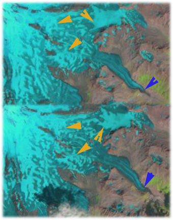
Irik Glacier flows down the southeast flank of Mount Elbrus, the highest peak in the Caucasus Mountains of Russia, red arrow on map points to current terminus of Irik Glacier, top image. The map terminus extended 1 kilometer further down the mountain. The glacier currently begins at 5000 m and descends to 2800 m, bottom image orange arrows indicate main accumulation areas, this compares to a terminus elevation of 2600 meters on the map.A decrease of area of glaciers of the Central Caucasus by 16% in the last 40 years is reported, on Elbrus the loss has been 8 % Russian Academy of Sciences National Geophysical Committee (2011). August 1998 (Top) and 2010 image (bottom) indicate the snowline on Irik Glacier, orange arrows and the glacier terminus blue arrows. The fraction of the glacier that is snowcovered is the accumulation area ratio (AAR), typically a glacier needs an AAR of 0.5-0.65 at the end of the melt season in September to be in equilibrium. For the nearby Djankuat Glacier, where annual mass balance data is reported to the World Glacier Monitoring Service, the AAR value for equilibrium is reported as 0.55. For Irik Glacier in 1998 and 2010 the AAR is 32 and 28 respectively and this is still with several weeks of melting. By the end of the melt season both would be below 0.3. The result of consistent negative balances is glacier retreat. For Irik Glacier the retreat from 1998 (top) to 2010 (bottom) is 600-700 meters, note blue arrows indicating terminus location and red arrow indicating a small rise on the southwest side of the glacier that the glacier used to wrap around, but no longer does. In a Google Earth image from 2009 the lower of the glacier is narrow and uncrevassed, this is a section that is quickly melting away. The orange arrows point out the lateral moraines from the Little Ice Age, the blue arrow the 1998 terminus and the red arrow the terminus in 2010. Irik Glacier must retreat to attempt to reestablish equilibrium with climate warming that has reduced the accumulation area. At present the lower 300 meters of the glacier is not crevassed and will melt away. Above that point the glacier is crevassed and vigorous in its flow.