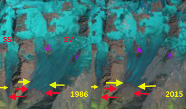
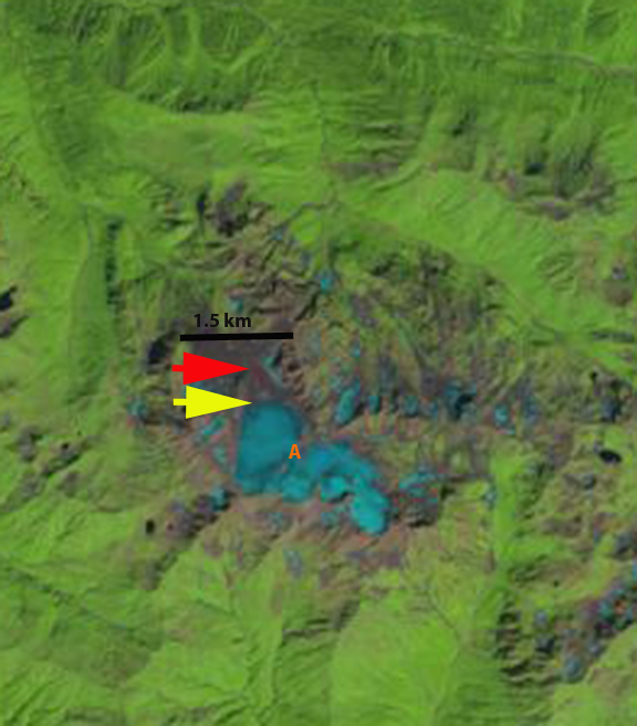
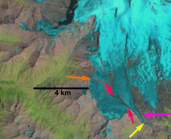
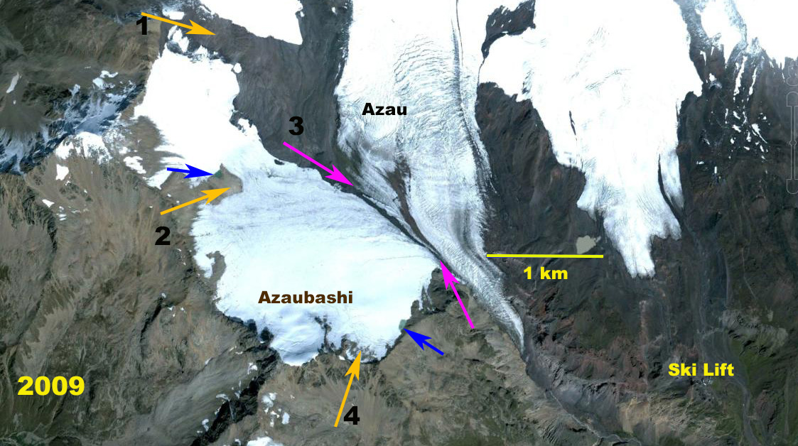
Azaubashi Glacier Fragmenting, Mount Elbrus, Russia

Azaubashi Glacier (W) and Azau Glacier (A) in 1985 Landsat and 2016 Sentinel Image. Orange arrows indicate particular areas of fragmentation and bedrock expansion.  Pink arrows indicate connection  with Azau Glacier the terminus of which in 1985 is at red arrow and in 2016 is at yellow arrow. 

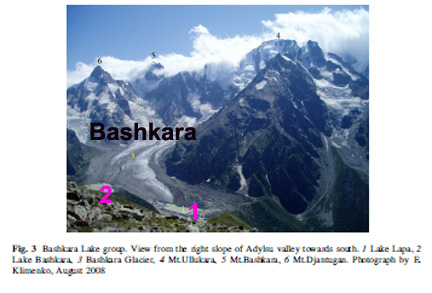
Azaubashi Glacier is on the southwest side of Mount Elbrus, Caucasus Mountains of Russia, merging with the Greater Azau Glacier. The glacier drains east from Gora Azaubashi (3600 m).  The glacier is west of the ski complex at Prielbrusye, that has lifts from Azau at 2300 m to Krugozor at 3000 m and Mir at 3500 m.  Shahgedanova et al (2014)  report  glaciers on the mountain experienced a 5% loss in area from 1999-2012, with the Azaubashi Glacier losing a much higher percentage.
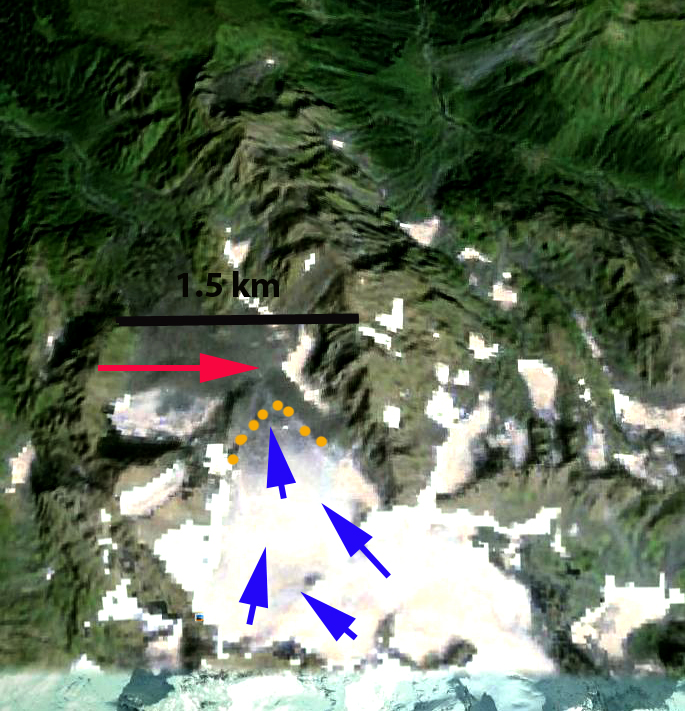
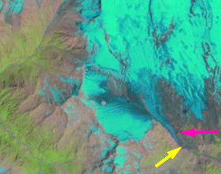
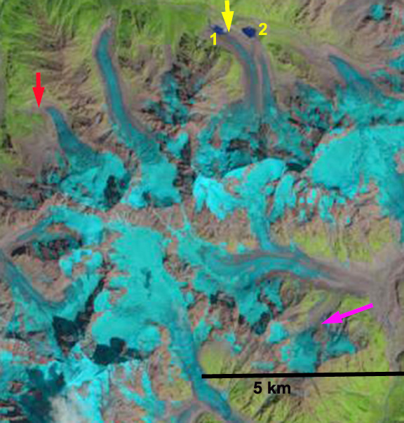
Azaubashi Glacier (W) and Azau Glacier (A) in 1998 and 2013 Landsat Images. Orange arrows indicate particular areas of fragmentation and bedrock expansion.  Pink arrows indicate connection  with Azau Glacier the terminus of which in 1985 is at red arrow and in 2016 is at yellow arrow. 

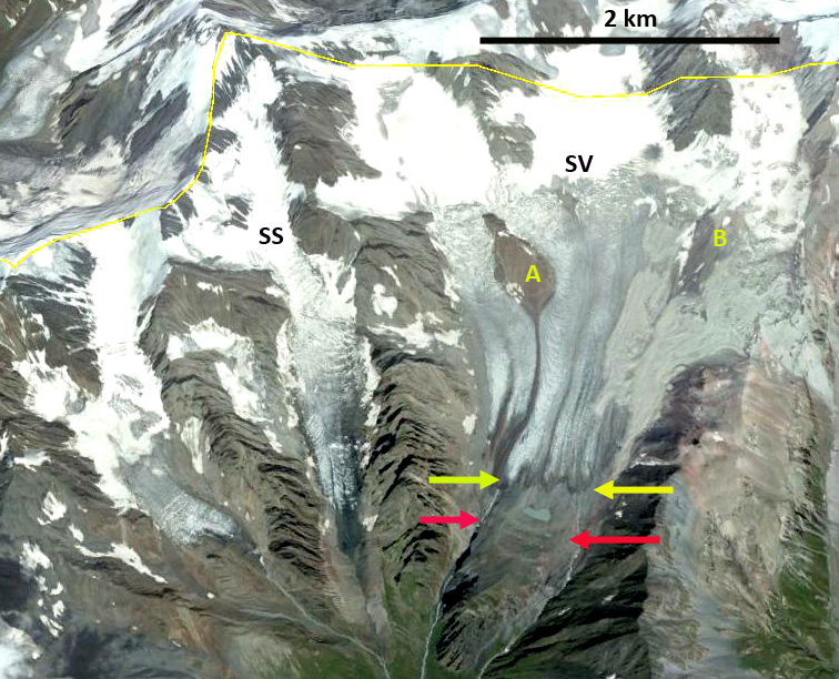
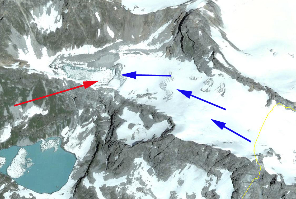
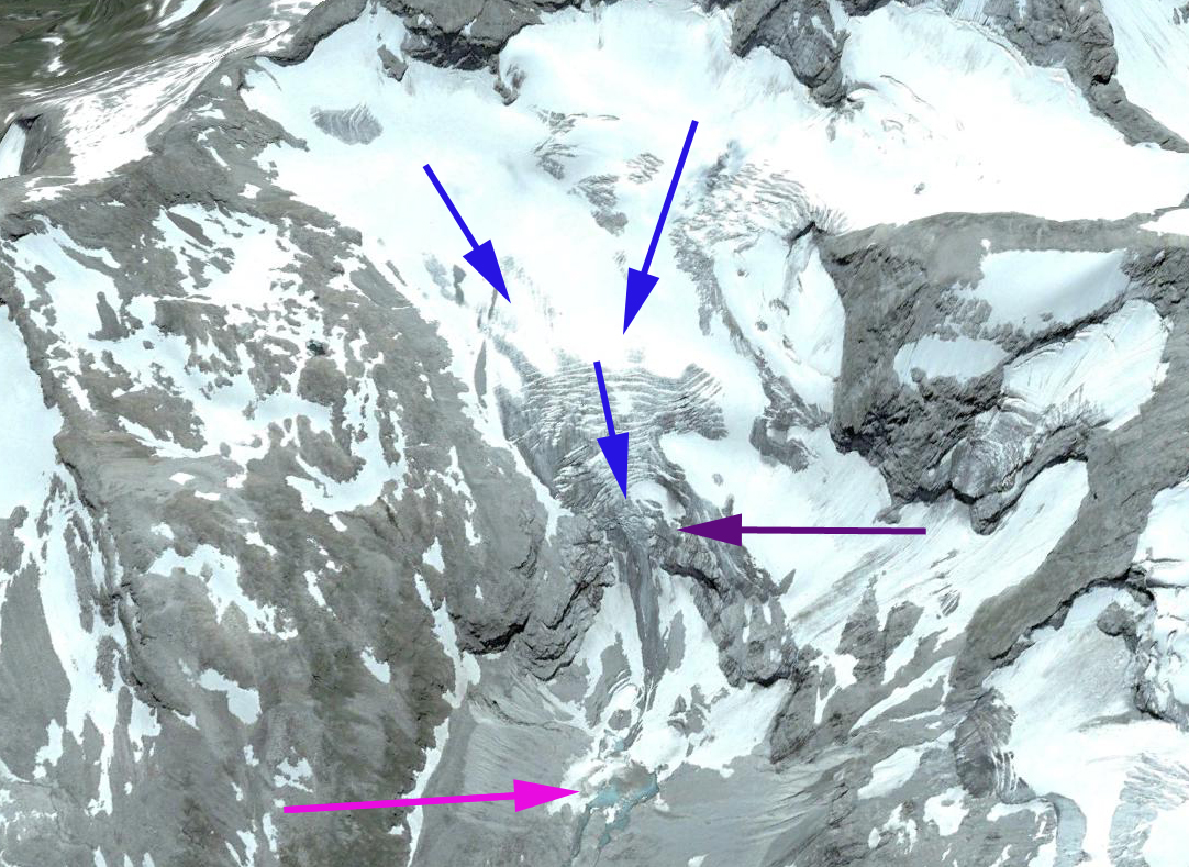
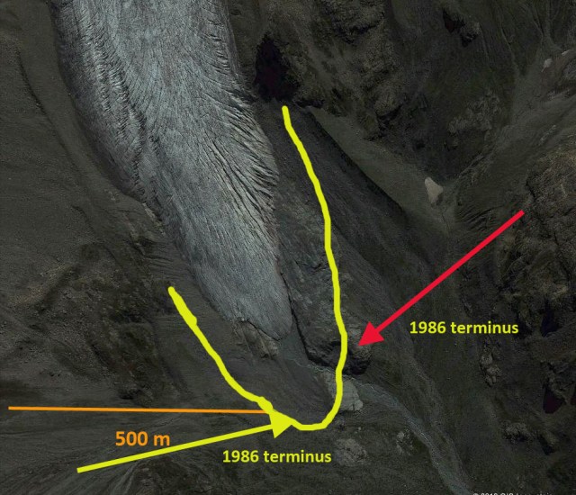
Here we examine Landsat images from 1985 to 2016 to quantify the substantial change. In 1985 the glacier extends north from Azaubashi to join with glaciers on the upper slopes of Elbrus in a 4 km continuous sweep.  At Arrow 1 and 2 the glacier is continuous and extends at least 800 m from top to bottom.  At Arrow 3 the glacier connection with Azau Glacier is extensive.  At Arrow 4 the glacier extends to the ridge.  By 1998 At Arrow 1 a bedrock arrow has nearly separated the glacier.  At Arrow 2 the glacier remains at least 700 m from top to bottom. The connection between Azaubashi and Azau Glacier remains extensive.  At Arrow 4 the glacier extends to the ridge.  By 2013, the bedrock exposed at Arrow 1 is 300 m wide.  At Arrow 2 the glacier is nearly severed with a connection of just 300 m.  At Arrow 3 the connection between glaciers is now discontinuous and tenuous.  At Arrow 4 the glacier no longer extends to the ridgeline,  The snowline on the south side of Mount Elbrus is at 3700 m. In 2016 the main change is the continued disconnection between Azaubashi Glacier and Azau Glacier, the connection that in 1985 was 1500 m long is now just 500 m long. The glacier will soon be split into three sections. The glacier did not retain any snowcover in 2016, in 1998 and 2013 less than 10% of the glacier retained snowcover.  The snowline in 2016 was at 3700 m on Aug. 28th. This indicates a glacier that cannot survive current climate as it lacks a consistent significant accumulation zone.  The retreat from 1985 to 2016 of the Azau Glacier noted at the red and yellow arrows has been 650 m.   The Azau Glacier still has an extensive accumulation zone.  TheAzaubashi Glacier is similar to the Dzhikiugankez Glacier in losing mass across nearly its entire surface.

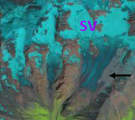
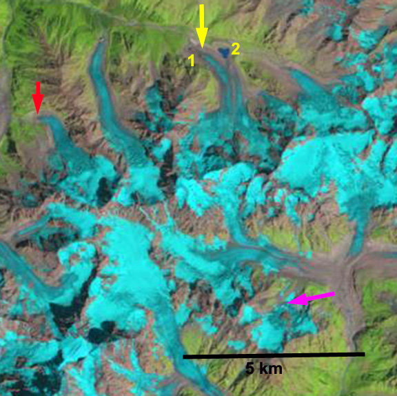
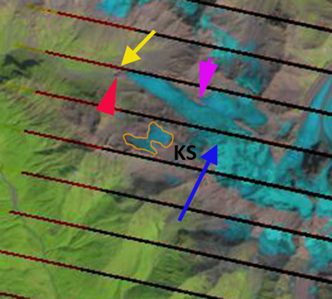
Azaubashi Glacier in 2009 Google Earth image. Orange arrows indicate particular areas of fragmentation and bedrock expansion.  Pink arrows indicate connection  with Azau Glacier, blue arrows indicate two small lakes developing in previously glacier covered areas. 

Suatisi Glacier Retreat, Mount Kazbek, Georgia

Suatisi compare

Comparison of Suatisi Vost (SV) and Suatisi Sredny (SS) in 1986 and 2015 Landsat images.  The red arrow is the 1986 terminus and the yellow arrows the 2015 terminus.  Point A and B are to areas of expanding bedrock amidst the glacier. 

Suatisi Vost and Suatisi Sredny Glacier are two glaciers on the south flank of Mount Kazbek in northern Georgia.  The region is prone to landslides and debris flows. On September 20, 2002 a collapse of a hanging glacier from the slope of Mt Dzhimarai-Khokh onto the Kolka glacier triggered an avalanche of ice and debris that went over the Maili Glacier terminus then slid over 15 miles (NASA Earth Observatory, 2002). It buried small villages in the Russian Republic of North Ossetia, killing dozens of people. The glacier runoff from Suatisi Glacier supplies the Terek River, which has a hydropower project under construction.  The Dariali Hydroplant will have an installed capacity of 108 MW and is a run of river type plant near Stepantsminda, Georgia. This plant has suffered from two landslides in 2014 (Glacier Hub, 2014) that jeopardize its completion.

Shagadenova et al (2014) examined glaciers in the Caucasus mountains and found that from 1999/2001 and 2010/2012 total glacier area decreased by 4.7%. They also noted that recession rates of valley glacier termini increased between 1987– 2000 and 2001–2010, with the latter period featuring retreats averaging over 10 m/year.  A positive trend in summer temperatures forced glacier recession (Shagadenova et al 2014). Here we examine changes in Suatisi Glacier from 1986 to 2015 with Landsat imagery.

In 1986 Suatisi Vost western side terminates at the top of deep canyon, red arrow.  The eastern side of the terminus is on a flatter till plain.  The area around Point B is all glacier ice.  Suastisi Sredny terminates near the end of the valley it occupies in 1986.  In the 2001 image a large debris flow/landslide has covered the eastern margin of Suatisi Vost surrounding the area of Point B, black arrow in 2001 image below.  By 2010 the Google Earth image indicates significant retreat of Suatisi Vost and the debris flow below point B is a light gray color. The bedrock at Point B has expanded.   By 2015 Suatisi Vost terminus has retreated 350 m since 1986, what is just as evident is the loss in width of the terminus in the 1986-2015 side by side comparison. Suatisi Sredny has retreated 450 m.  The snowline is at an elevation of 3750-3800 m in 1986, 2010 and 2015. With the terminus at 3250 m and the highest elevation at 3950-4000 m, this is too high to sustain the glacier at its current size and retreat will continue. The debris cover has reached the terminus on the east side of the glacier by 2015. The changes are the same across the border in Russia, for example Lednik Midagrabin.

suatisi ge

2010 Google Earth image of Suatisi Vost and Suatisi Sredny.  

suatisi 2001

2001 Landsat image indicating the landslide covering surface of Suatisi Vost.

suatisi j2015

2015 Landsat image indicates Landslide deposit evolution, with movement downglacier and retreat, it is now close to the ice front on the east side of the margin.

Dzhikiugankez Glacier Poised to Melt Away, Mount Elbrus, Russia.

Dzhikiugankez Glacier (Frozen Lake) is a large glacier on the northeast side of Mount Elbrus, the highest mountain in the Caucasus Range. The primary portion of the glacier indicated in the map of the region does not extend to the upper mountain, the adjoining glacier extending to the submit is the Kynchyr Syrt Glacier. The glacier is 5 km long extending from 4000 m to 3200 m. Shahgedanova et al (2014) examined changes in Mount Elbrus glaciers from 1999-2012 and found a 5% area loss in this short period and accelerated retreat from the 1987-2000 period. As examination of Landsat images indicates Dzhikiugankez Glacier has the lowest percent of overall snowcover, as seen in the satellite image from August 2013 with the transient snow line shown in purple. The amount of blue ice is apparent on Dzhikiugankez Glacier (D). The main changes in this glacier are not at the terminus, but along the lateral margins, indicating substantial vertical and lateral thinning. Here we examine Landsat imagery from 1985 to 2013 to identify changes. In each image the red arrow indicates bedrock on the western margin, the yellow arrow bedrock on the eastern margin, Point A an area of glacier ice extending to the upper eastern margin, the purple arrow a medial moraine exposed by retreat and the green arrow the 1985 terminus of the glacier.

Elbr01
Map of northeastern side of Mount Elbrus, summit on left. Dzhikiugankez Glacier (Dzhikaugenkjoz) is outlined in black.

elbrus glaciers tsl 2013
August 2013 Satellite image of Mount Elbrus

kinger sirt ge
Google Earth image 2013

In 1985 the glacier connects beneath the subsidiary rock peak at the red arrow, a tongue of ice extends on the east side of the rock rib at the yellow arrow, Point A. The transient snow line is at 3550 m and less than 30% of the glacier is snowcovered. The medial moraine at the purple arrow is just beyond the glacier terminus. In 1999 the subsidiary peak is still surrounded by ice and the tongue of ice at Point A though smaller is still evident. The snowline is quite high extending to 3750 m, leaving only 10-15% of the glacier snowcovered. In 2001 the main terminus has retreated from the green arrow. A strip of rock extends up to the red arrow. The snowline is at 3500 m, with a month of melting left. In 2013 a wide zone of bare rock extends up to the subsidiary peak at the red arrow.  The medial moraine, purple arrow is exposed all the way to its origin near the red arrow.  In 2013 the tongue of ice at Point A, is gone.  This glacier is retreating faster on its lateral margins as  at the terminus, a 20% reduction between red and yellow arrows from 1985 to 2013. The snowline is at 3600 m, with several weeks of the melt season left. The key problem for the Dzhikiugankez Glacier is that there is an insufficient persistent accumulation zone.  Pelto (2010) noted that a glacier cannot survive without a persistent and consistent accumulation zone, which Dzhikiugankez Glacier lacks despite being on the flanks of Mount Elbrus. Retreat of this glacier is similar to Azau Glacier, particularly the west slope of this glacier, and Irik Glacier.  Unlike these glaciers it cannot survive current climate.  The glacier is large and the glacier will not disappear quickly. Shahgedanova et al (2014) note the expansion of bare rock areas adjacent to glaciers on the south side of Mount Elbrus including Azau and Garabashi.

lednik ks 1985
1985 Landsat image

lednik ks syrt 1999

1999 Landsat image
lednik ks 2001
2001 Landsat image

lednik ks 2013
2013 Landsat image

Kluhor Glacier Retreat, Caucasus Mountains, Russia

Kluhor (Klukhor) Glacier is in the Caucasus Mountains west of Mount Elbrus. It drains into the Teberda River and then the Kuban River and eventually Krasnodar Reservoir and the Black Sea. The Krasnodar Reservoir is primarily a flood control and irrigation management reservoir. Here we examine three glaciers each experiencing the familiar pattern in the Caucasus Mountains of retreat with expansion of proglacial lakes. As the area and number of glacier is reduced, the number and area of alpine lakes is increasing, note Khimsa Glacier, Georgia, Psysh Glaciers, Russia, and Gora Bashkara, Russia. Stokes et al (2006) note that 94% of Caucasus Mountain glaciers retreated from 1985 to 2000 and it is clear from the aforementioned that the trends continues.
klukhori glacier ge lg

We examine Landsat imagery from 1998 and 2013 to identify the change. In each image the Kluhor Glacier terminus lake is indicated by the red arrow. The unnamed Glacier here named east Kluhor Glacier terminus lake is noted with a yellow arrow. Another unnamed glacier on Lednik Daut is identified here as north Daut Glacier is noted by pink and purple arrows. In 1998 there is small lake at the end of Upper Kluhor Glacier, 150 m long, and on east Kluhor Glacier, 50-100 m wide. At north Kluhor Glacier the glacier ends at the base of a steep icefall near a third lake, pink arrow. The purple arrow indicates the terminus of north Daut Glacier in each image. By 2013 Kluhor Glacier has retreated 300 m and the lake is 450-500 m long. The east Klhor Glacier has retreated 150 m and the lake is 250 m across. The north Daut Glacier has retreated to the top of the steep icefall slope, a 400 m retreat and is now quite distant from the lake below.

The 2007 Google Earth image of Kluhor Glacier there are a number of crevasses paralell to the ice front, indicating that some calving losses will continue to occur. The glacier overall extends from 2950 m to 3250 m, is narrow and has limited snowcover in both satellite images. The snowcover extent in the August satellite images, well before the end of the melt season is 30%, whereas typically 55-65% is necessary to sustain a glacier. In the 2007 Google Earth imagery the thin nature of the icefall at north Daut Glacier is evident, that has since melted away.
kluhor Glacier 1998
1998 Landsat image

kluhor glacier 2013
2013 Landsat image

klukhori glacier lake
2007 Google Earth image of Kluhor Glacier

klukhori glacier n
2007 Google earth image north Kluhor Glacier

Khimsa Glacier Retreat, Georgia

Khimsa Glacier is a rare significant glacier south of the main crest of the Caucasus Mountains in Georgia. The glacier drains north to the Bzyb River, and then the Black Sea. The rivers upper reach is quite undeveloped and there is no hydropower along the river to date. The glacier flows from an elevation of 3000 m to 2650 m. In 1998 the glacier was 1.6 km long with a narrow terminus at the red arrow. At the transition to the glacier’s upper eastern slopes at Point A, there is only one small rock exposure. By 2013 the glacier has retreated 400 m to the yellow arrow, having lost 25% of its length in 15 years. The area of bedrock exposed on the upper eastern slope, at Point A, is significant now indicating thinning even high on the glacier. The glacier will soon separate near Point A into an upper and a lower section. In the Google Earth image the current terminus is indicated with orange dots and the glacier flow with blue arrows. Like Psysh Mountain glaciers 25 km north Khimsa Glacier thinning high on the glacier indicates it cannot survive current climate. Caucasus Mountain glaciers are in a period of rapid retreat (Shagedenova et al, 2009), that is attributed mainly to rising summer temperatures. Khimsa Glacier’s retreat parallels that of glaciers along the main crest of the Caucasus such as Kirtisho or Azau Glacier, though as a percent of total area lost it is greater.

khimsa glacier 1998
1998 Landsat image

khimsa glacier 2013
2013 Landsat image

khimsa ge

2010 Google Earth image

Greater Azau Glacier, Mount Elbrus, Russia

Greater Azau Glacier is on the south slopes of Mount Elbrus, Caucasus Mountains of Russia. The glacier is just west of the ski complex at Prielbrusye, that has lifts from Azau at 2300 m to Krugozor at 3000 m and Mir at 3500 m. This glacier like others on Mount Elbrus and in the Caucasus Mountains is retreating. Russian Academy of Sciences remapping of the glaciers on the mountain indicate a 15% loss in area from 1911 to 1957 and 7% loss from 1957-2000. elbrus glaciers
2013 Landsat of Mount Elbrus and its glaciers.

azau ge
2009 Google Earth image of Azau Glacier.

In 1998 the glacier descended to an elevation of 2650 m ending at the yellow arrow. The pink arrow indicates a knob adjacent to the 2013 terminus. The red arrows indicate the length of the connection of the slope glacier to the west of the main valley tongue of the Azau Glacier, it is 1 km. The orange arrows indicates a thin connection between two segments of the upper glacier on the western slopes above Azau Glacier. IN 2001 the terminus has retreated a short distance from 1998. By 2013 the terminus has retreated 450 m to just beneath the knob at the pink arrow, 30 m per year. The terminus is now at 2850 meters. The glacier on the western slopes has separated at the orange arrow and the connection at the red arrows has been reduced to 200 meters from 1000 meters in 1998. A close up view of the terminus in 2009 indicates that it is still just downvalley of the prominent knob. Only the lower 300 m of the glacier is uncrevassed, above this point active crevassing is widespread. The Krugozor Ski Station is also noted. This glacier is retreating faster now than during the 1957-2000 period like the Irik Glacier to the east on Mount Elbrus. This likewise is the pattern of retreat observed elsewhere in the Caucasus at Gora Bashkara,Kirtisho Glacier and Lednik Karaugom Glacier. The glacier still has an extensive accumulation zone.
azau glacier 1998
1998 Landsat image

azau glacier 2001
2001 Landsat Image

azau glacier 2013
2013 Landsat Image

azau terminus
2009 Google Earth Image

Gora Bashkara Region Glacier Retreat, Western Caucasus, Russia and Georgia

In the vicinity of Bashkara Glacier in the Western Caucasus we examine using Landsat imagery the response of several glacier over the 1998 to 2013 period. This region has been experiencing widespread significant retreat (Shahgedanova et al 2009), with average retreat of 8 m per year due in large part to increased summer temperatures. This region has been an area of increased proglacial lake formation as well Stokes et al (2007). Petrakov et al (2011) examined changes in the lakes at the margin of Bashkara Glacier. They examined three lakes near the margin of the glacier and identified large expansion of two of them due to glacier retreat. They found the terminus reach to be stagnant and thinned 13 meters from 1999 to 2007. Lake Lapa has expanded eastward 250 m since 1999 due to terminus retreat Petrakov et al (2011). bashkara lakes
Image from Petrakov et al (2011). Lake Lapo=1 and Lake Bashkara=2.

In 1998 only Bashkara Lake is substantial in sie, yellow arrow. Two valleys to the west an unnamed glacier ends at the red arrow after taking a sharp right turn. At the pink arrow an unnamed mountain glacier descends from the upper basin at m to the lower valley where it terminates. In 2001 little has changed at the three locations. By 2013 Lake Lapo the western most lake at the yellow arrow has expanded as the glacier has retreated that Petrakov et al (2011) noted. The unnamed glacier at the red arrow has retreated 500 m and now barely rounds the turn to the west. At the pink arrow the glacier now no longer descends from the upper basin to the lower valley. The terminus region in the valley bottom has melted away, a retreat of 400-500 m. The retreat of these glacier follows that of other glacier in the region Great Azau Glacier, Kirtisho Glacier and Lednik Karaugom Glacier. baykara 1998
1998 Landsat image

baykara 2001
2001 Landsat image

baykara 2013
2013 Landsat image

Kirtisho Glacier Retreat, Georgia

The southern flank of the Caucasus Mountains is in the nation of Georgia. Ten kilometers southwest of the Lednik Karaugom Glacier, Russia from the previous post is Kirtisho Glacier a 4.5 km long valley glacier, a small subglacier KS is also examined in this post.caucasus submap The glaciers in the Causcasus Mountains have been undergoing a significant retreat, the USGS, (2010) Satellite Image Atlas of Asia, noted that nearly all of the 65 glaciers examined in this region experienced significant retreat from 1987-2004. Shahgedanova et al, (2009) noted a 8 meters per year average retreat rate for the 1985-2000 period. To get a feel for the terrain watch the trailer for the On the Trails of the Glaciers- Caucasus 2011. The video does not show Kirtisho Glacier but does indicate the nature of the terrain. This is a project of an Italian group Macromicro, that had contacted me about an upcoming expedition to Alaska in 2013. Landsat images from 1986 (second image) and 2012 (third image) along with 2011 Google Earth imagery (top and bottom image) are shown below. Kirtisho Glacier has a top elevation of 3700 meters and a terminus that in 2012 is at 2600 meters, and was 2400 m in 1986. The snowline has typically been at 3300 meters, blue arrow, which is too high to sustain the terminus at 2600 m. The terminus position in 1986 is indicated by a red and yellow arrow that are also used in the 2012 imagery and the 2011 terminus closeup. The magenta arrow in the Landsat images indicates the beginning of a separation from an northern tributary, which is close to the snowline. The terminus itself is not crevassed in the lowest 400 meters, suggesting retreat will continue for this nearly stagnant section. KS the small glacier to the south, has decreased in area from 0.45 km2 in 1986 to 0.20 km2 in 2012. We also examine this more below. kirtisho glacier profile

kirtisho 1986Kirtisho 2012

kirtisho terminus The KS glacier viewed up close is quite thin, with limited crevasses. The red arrows indicate rock protruding through this glacier in many locations. These rocks indicate how thin the ice is, and will help absorb heat and hasten melting as the rock outcrops expand. In 2011 and in the 2012 imagery there is no remaining snow on the glacier. A glacier without a persistent accumulation zone cannot survive (Pelto, 2010). KS glacier will not survive much longer. ks 2011

Lednik Karaugom Glacier Retreat Caucasus Mountains, Russia

Lednik Karaugom Glacier is a large 13 km long, valley glacier in the Caucasus Mountains of Northern Ossetia, Russia. The glacier drains into the Urukh River which joins the Terek River and then flows into the Caspian Sea. This post compares Landsat imagery from 1986, 2010 and 2012, an image from the USGS in 2002 and Google Earth imagery from 2009. This glacier has experienced a general retreat like all the glacier draining north from the Caucasus Mountains. USGS, (2010) Satellite Image Atlas of Asia, noted that nearly all of the 65 glaciers examined in this region experienced significant retreat from 1987-2004, noting a retreat of Karaugom of 600 m. Maria Shahgedanova, has an ongoing project examining Caucasus glaciers. Shahgedanova et al, (2009) noted a 8 meters per year average retreat rate for the 1985-2000 period. The glacier retreat has led to an increase in debris cover and an increase in the number of proglacial and supraglacial lakes. (Stokes et al , 2007) This glacier begins at the Russia-Georgia border and extends up to the base of Gora Uilpata at 4200 meters. There is a substantial icefall separating the accumulation zone above 3500 meters from the ablation zone of the valley tongue beginning at 2500 m.karpovareafrom 1987-2002. In the series of images below the yellow arrow indicates the 1986 terminus position, the pink arrow the 2012 terminus position, the orange arrow the 2002 terminus position and the blue arrow the former connection with a tributary. The retreat from 1986 to 2012 is 1300 meters, about 50 meters/year. The retreat of the tributary from the main glacier has been 200 meters, or 8 meters/year. karaugom glacier 2002
karaugom glacier 1986
karaugom glacier 2010
karaugom Glacier 2012
A closeup of the terminus indicates the amount of debris cover, and the formation of ogives at the base of the icefall. The lateral moraine marking the previous ice surface elevation is also noted with a green arrow. This glacier remains vigorous in its flow, with substantial crevassing and ongoing crevasse formation. The retreat is ongoing but the end of the glacier is not stagnant, though the lower 300 meters has reduced crevassing and width. The degree of crevassing at the green arrows at a small icefall 300 meters above the terminus indicates both ice thickness and flow and suggest that the retreat will likely be reduced in the near future. The behavior is similar to that of Lednik Fytnargin and Irik Glacier on Mount Elbrus karaugom icefall

Lednik “Fytnargin” Retreat, Caucasus Range

Most alpine glaciers in the world remain unnamed, many of these are small, but some are just remote. Their story is no different from the named glaciers. An example is the glacier that drains the north side of Gora Fytnargin (4123 m). I will designate this Lednik “Fytnargin” for the purposes of this discussion. This glacier drains north from the boundary of Georgia and North Ossettia, Russia. The terminus is at 2460 meters, the top at 4100 meters and the snowline at 3200 m. Google Earth provides two excellent views of the lower glacier from September 2006 (top image below) and September, 2009 (bottom image). In this three year interval the terminus of the glacier has retreated 450 meters. In 2006 a debris stagnant terminus area exists, that entirely melted away in three years. . The retreat of this glacier follows the pattern of glaciers in the region that are monitored. Stokes et al (2007) used satellite imagery to observe 113 glaciers in the region from 1980-2000 and found 95% to have retreated. They observed that the rate of retreat had increased and that a number of new lakes had formed due to the retreat. Lednik Fytnargin’s terminus has a low slope and limited crevassing and has numerous supraglacial stream channels. The combination of these indicates rapid retreat will continue in the near future. The terminus was located at 2380 m in 2006 and 2460 m in 2009