Cook Ice Cap Outlet Glacier Retreat Lake Fromation, Kerguelen 2001-17


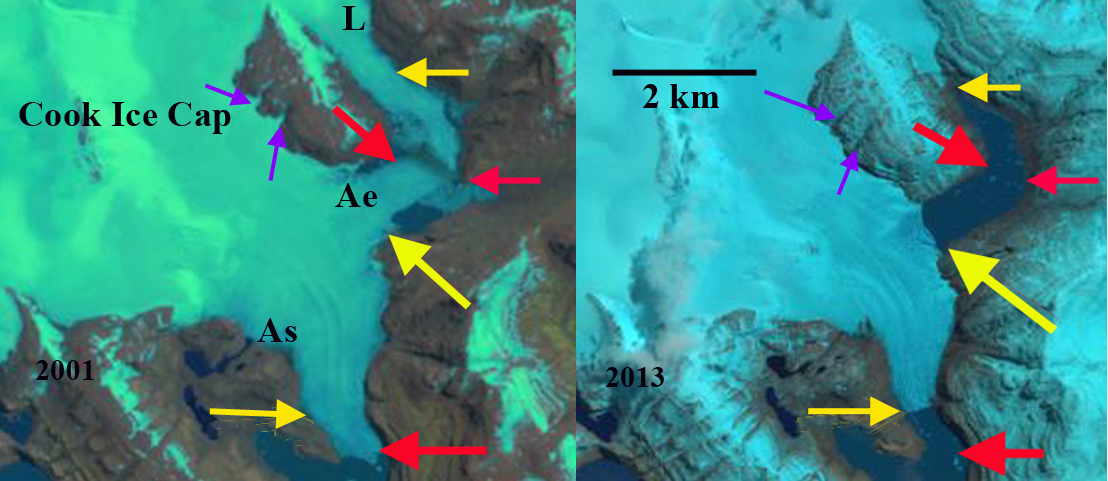
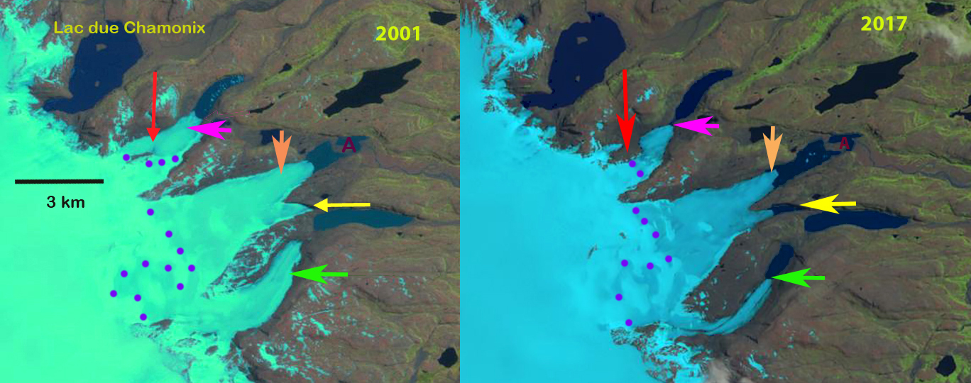
Comparison of eastern outlet glaciers of the Cook Ice Cap in 2001 and 2017 Landsat images.  Red arrow indicates a location of tributary separation. Pink arrow the 2017 terminus location of the northernmost glacier. Orange arrow the 2017 terminus location of the middle glacier.  Yellow arrow tip the 2001 terminus position of glacier ending in newly formed lake.  Green arrow the southernmost glacier 2017 terminus location. 

On the east side of the Cook Ice Cap on Kerguelen Island a series of outlet glaciers have retreated expanding and forming a new group of lakes.  Here we examine the changes from 2001-2017 along using Landsat imagery. Retreat of glacier in the region was examined by Berthier et al (2009) and is exemplified by the retreat of Ampere Glacier.  Verfaillie et al (2016) examined the surface mass balance using MODIS data, field data, and models.  They identified that accelerating glacier wastage on Kerguelen Island is due to reduced net accumulation and resulting rise in the transient snowline since the 1970s, when a significant warming began.

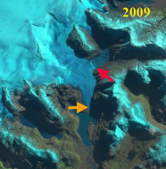
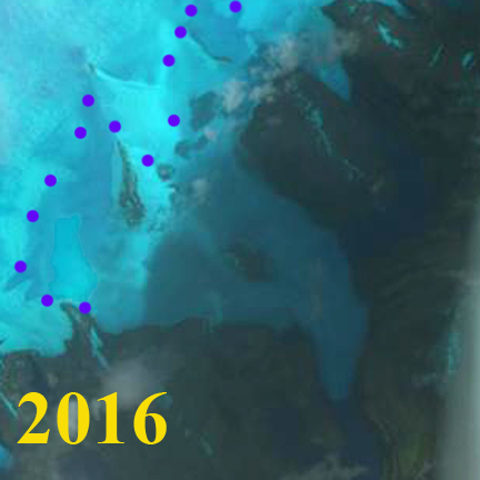
In 2001 at the red arrow is where the north tributary of a glacier ending in the northern most lake joins the main glacier.  In the second lake is a peninsula, marked with point A that the glacier terminus is 1 km from. The next two glaciers terminating at the yellow arrow and beyond the green arrow do not have lakes at their termini.  By 2014 the northern tributary has lost its connection with the main glacier terminating in the lake. The distance from the island for the middle glacier has increased.  A lake is forming at the yellow arrow. For the third glacier a lake has formed at the green arrow. In 2017 the northern glacier has retreated to the pink arrow a distance of  750 m and is no longer terminating in the lake. The terminus at the orange arrow has retreated  main terminus has retreated 900 m, expanding the lake it terminates in.   The glacier at the yellow arrow has retreated into a new lake basin, with a retreat of 850 m since 2001. The terminus is thin and in the Google Earth image indicates some substantial thin icebergs have separated from the glacier. The green arrow marks the 2017 terminus of the southern most lake. This glacier has retreated 950 m leading to the continued expansion of a new lake.  In just a decade we see the formation of two new lakes and the expansion of two others at the terminus of the eastern outlet glaciers of Cook Ice Cap, rapid landscape change driven by climate change.

2014 Landsat image of the eastern outlet glaciers of Cook Ice Cap.Red arrow indicates a location of tributary separation. Pink arrow the 2017 terminus location of the northernmost glacier. Orange arrow the 2017 terminus location of the middle glacier.  Yellow arrow tip the 2001 terminus position of glacier ending in newly formed lake.  Green arrow the southernmost glacier 2017 terminus location. 

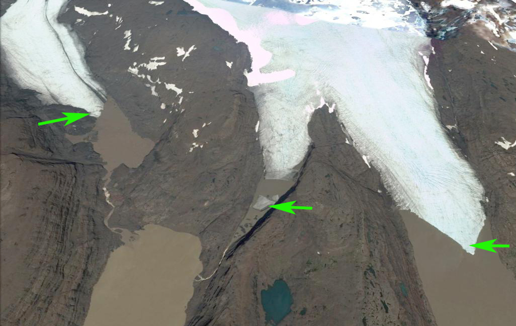
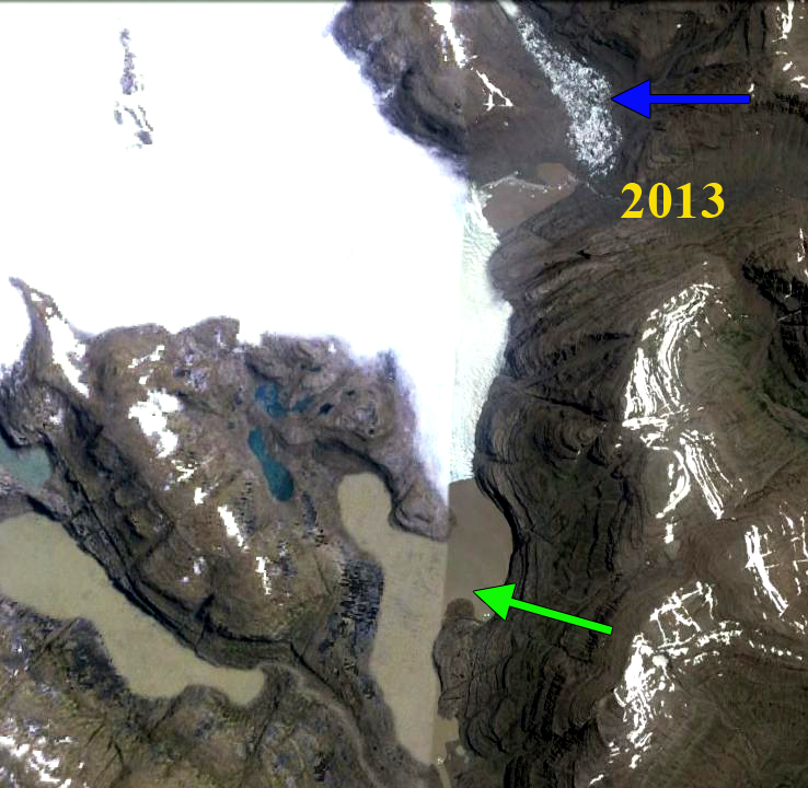
Terminus of three outlet glaciers from left to right the green arrow, yellow arrow and orange arrow terminus glacier on the Landsat images.  The green arrows indicate places where the terminus or icebergs illustrates how thin the glacier ice is. 

Ampere-Lapparent Glacier Retreat, Kerguelen Island

ampere compare

Comparison of Ampere Glacier (A) and Lapparent  Glacier (L) southern outlet glaciers of the Cook Ice Cap in 2001 and 2013 Landsat images; red arrow indicates 2001  terminus locations, yellow arrows 2013 terminus locations and purple arrow upstream thinning.

Kerguelen Island sits alone at the edge of the furious fifties in the southern Indian Ocean. The island features numerous glaciers, the largest being the Cook Ice Cap at 400 square kilometers. A comparison of aerial images from 1963 and 2001 by Berthier et al (2009) indicated the ice cap had lost 21 % of its area in the 38 year period.  Ampere Glacier is the most prominent outlet glacier of the Cook Ice Cap.  Berthier et al (2009) noted a retreat from 1963 and 2006 of 2800 meters of the main glacier termini in Ampere Lake (As). The lake did not exist in 1963. A second focus of their work was on the Lapparent Nunatak due north of the main terminus and close to the Ampere Glaciers east terminus (Ae). The nunatak expanded from 1963-2001, in the middle image below from Berthier et al (2009), but it was still surrounded by ice.  This is dominated by cloudy weather, with not a single good Landsat image of the glacier since 2013, the January 2016 indicates the snowline, purple dots is similar to 2001.

Kerguelen-Island-topo-Map

Map of Kerguelen Island

The main terminus has retreated 800 meters from 2001-2013. Here the terminus has pulled back from the tip of the peninsula on the west side of the terminus and is currently at a narrow point.  The eastern terminus has retreated to its junction with the main Ampere Glacier a distance of 1400 m.  Berthier et al (2009) had noted thinning around the Lapperent Nunatak of 150 to 250 m, purple arrows indicate this location of thinning.  Above the current main terminus the valley widens again to the junction with the location of the eastern terminus.  It seems likely the main glacier will retreat north until there is a single terminus north of the southern end of Lapparent Nunatak. Lapparent Glacier was formerly joined with the Ampere Glacier’s eastern outlet.  The comparison of  Landsat imagery from 2001 and 2013 indicate widespread thinning and deglaciation of this glacier.  In 2001 Lapparent Glacier merges with the east terminus of Ampere Glacier at the red arrows with a medial moraine evident.  By 2013 the eastern arm has narrowed from 1100 m to 500 meters and retreated 2100 m in 12 years. The result is less ice flow over a bedrock step just above the terminus. This continued thinning since 2001 will lead to further retreat of the glacier. There is no calving and the rate of retreat will decline. A 2009 Landsat image 2009 and 2013 Google Earth image indicate icebergs stranded in the lake by Lapparent Glacier and the eastern outlet indicating glacier lake drainage lowering the level.

ampere-hd

2009 Landsat image icebergs evident in lake in the upper right.

ampere ge

2013 Google Earth, icebergs at blue arrow.  Highly turbid water in proglacial lakes indicates a recent high flow event.

amperre 2016

2016 Landsat image