Pacliash Glacier, Peru Retreat and Lake Expansion

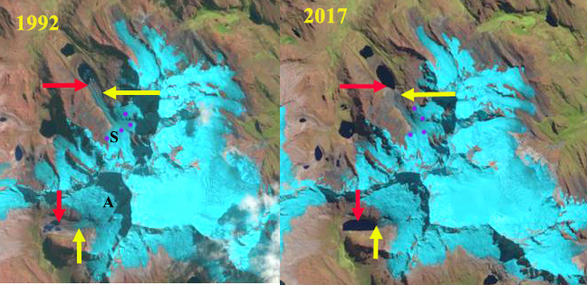
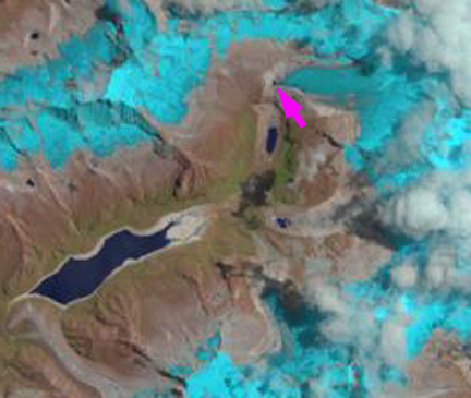
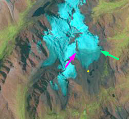
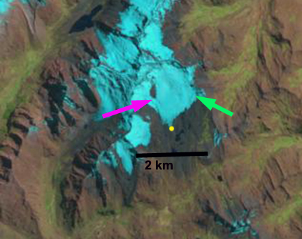
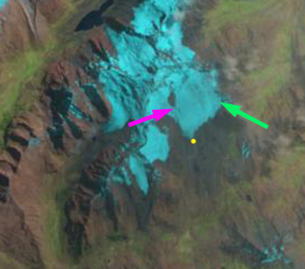
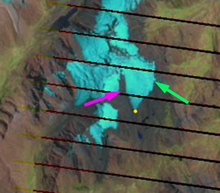
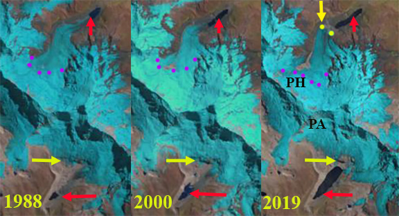
Retreat and lake expansion at Pacliash Glacier (PH) and Palcaruja Glacier in the Cordillera Blanca, Peru illustrated with 1988, 2000 and 2019 Landsat images.  Red arrow is the 1988 terminus, yellow arrow the 2019, purple dots are the snowline.

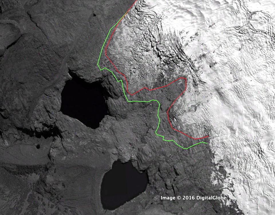
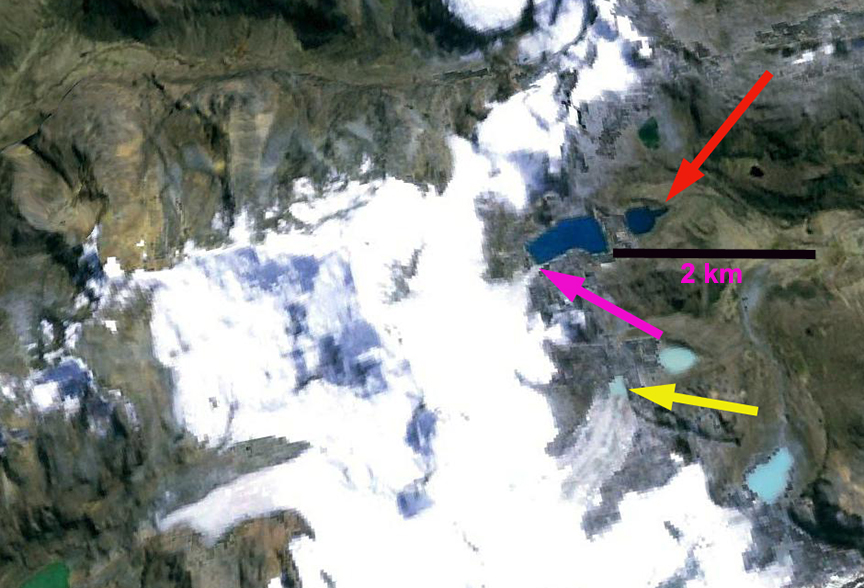
Pacliash Glacier is in the Cordillera Blanca of Peru, on the northeast flank of Palcaraju and Tocllaraju had until recently terminated in Laguna Pacliashcocha.  This region has seen substantial glacier retreat and area loss.  Glacier lakes have increased in number and expanded during this retreat.   Laguna Pacliashcocha is impounded by a glacier moraine that experienced a breach in 1997, resulting in minor GLOF in 1997 (Carey, 2010).  This led to the temporary drainage of this lake over the next several years (Carey, 2010).  Palmer (2019) reported on the expanding lake volume, continued GLOF hazard and engineering mitigation at the Palcacocha Lake that lies below the Palcaruja Glacier.  Veettil and Kamp (2019) note a 25% decline in glacier area in the Cordillera Blanca after 1987. Here we examine the rapid retreat of the glacier and the consequent expansion of the lake and the impact on GLOF potential.

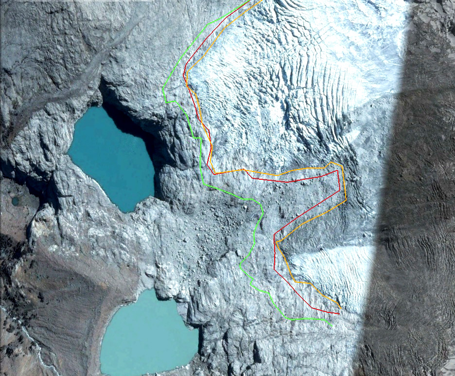
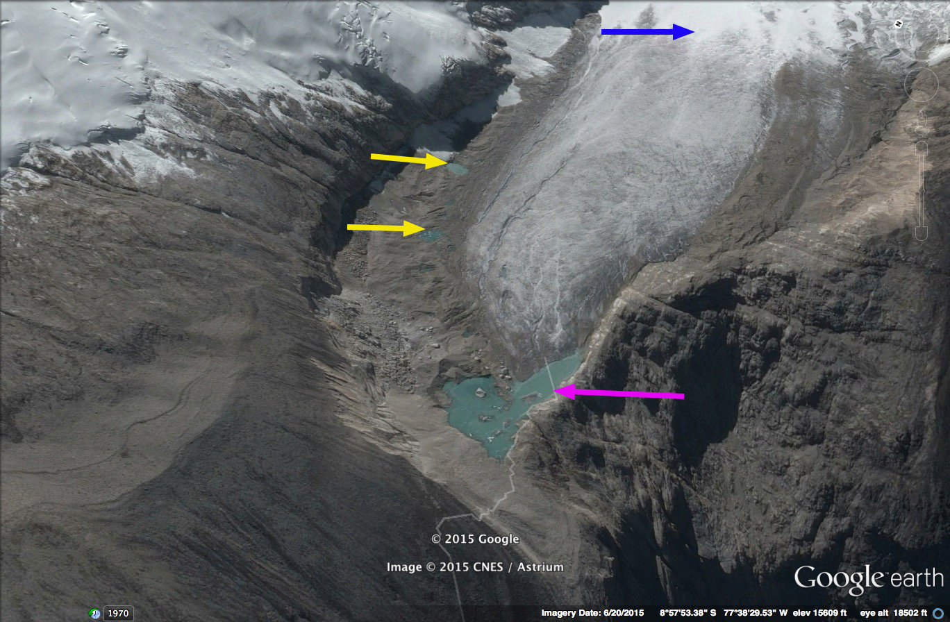
In 1988 Pacliash Glacier terminated in the lake, which had an area of 0.1 km2 and was 0.4 km long. The lowest 2 km of the glacier was heavily snowcovered and the snowline is at 5000-5100 m.  In 2001 the lake had expanded to an area of 0.18 km2 and 1.0 km long, the snowline was at 5000-5100 m.  By 2016 the glacier has retreated from the lake and terminated 250 m from the lake margin.  The snowline is at 5300-5400 m.  In 2019 the glacier terminates 300 m from the lake margin, the retreat from 1988-2019 is 1500 m.  The lake is 1.25 km long and has an area of 0.28 km2 in 2019.  The snowline is at 5300-5400 m, the higher snowline is the driving force behind the retreat.  The smaller glacier yields less glacier runoff (Carey, 2010).  This is one of many clear examples of glacier watershed fed hydrologic systems and the connected social systems in the Andes being transformed by global change (Mark et al, 2017).

The GLOF threat in this case has declined as the glacier has receded from the lake and is ending on a slope that is not steep enough to easily have an avalanche travel across/from the glacier to the lake.  Palcaruja Glacier has experienced a similar retreat and lake expansion, but has a much steeper slope from the terminus to the lake, hence the avalanche risk into the lake generating a GLOF remains high (Palmer, 2019). Emmer et al (2016) notes that the number of GLOF’s were greater from moraine dammed lakes in the region early in the retreat phase in the 1940’s and 1950’s.  This suggest the moraines are becoming more stable with time since formation and glacier retreat.

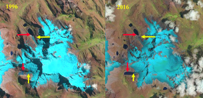
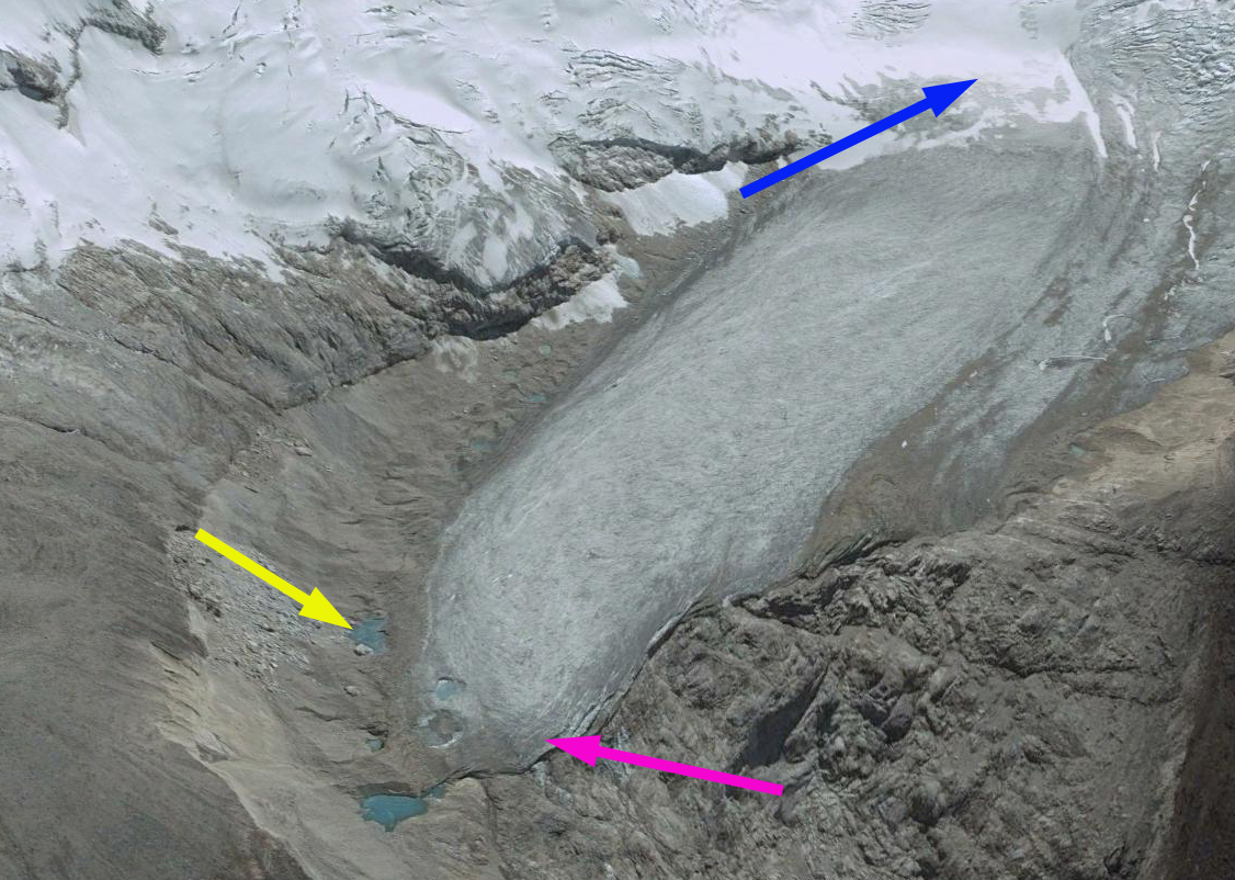
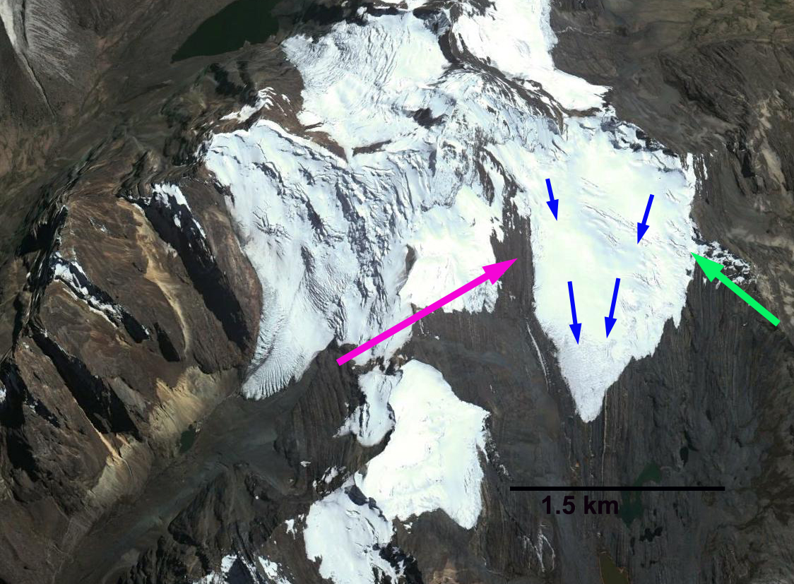
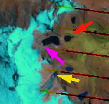
Digital Globe image of Pacliash and Palcaruja Glacier in 2016, red arrow is the 1988 and yellow arrow the 2019 terminus.  Blue arrows show glacier flow direction. 


Safuna & Arhuey Glacier, Peru Retreat from Lakes

Safuna Glacier (S) and Arhuey Glacier (A) in 1992 and 2017 Landsat images indicating glacier retreat from the 1992 terminus red arrow to the 2017 terminus position yellow arrow.  Snowline indicated by purple dots.

Safuna Glacier (S) is at the northern end of the Cordillera Blanca Range, Peru flowing north from Nevados Pucajirca.  Arhuey Glacier (A) is adjacent to Safuna and flows west formerly terminating in Arhuey Lagunacocha impounded by a moraine. Safuna Glacier in 1992 terminated in Laguna Safuna Alta, which is impounded by a moraine dam and has a history of water level fluctuations.   Reynolds Geosciences (2003) provides a detailed look at the lake, moraine and associated engineering.  The moraine appeared unstable in the 1960’s prompting excavation of  a tunnel through the moraine in 1970, which ended up below the lake water level after the lake surface elevation dropped 25 m in late 1970.  In 1978 a second tunnel was constructed, that to date remains above the lake waterline and has not been used.  The Peruvian Government was early in their proactive engineering to address glacier lake outburst flood hazards (Carey, 2008). In 2002, a rockslide created a wave of at least 80 meters in height (Reynolds Geosciences , 2003), overtopping the moraine and damaging both tunnels but not damaging the moraine.  This landslide also filled in the lake reducing depth significantly. Here we examine changes  from 1992 to 2017 using Landsat imagery from July of Safuna Glacier (S) and Arhuey Glacier (A). Though glacier outburst floods have capture more attention it is the overall reduction in glacier water runoff that has more impact on local communities (GlacierHub-Angle, 2017).

In 1992 the glacier terminated in the 800 m long Laguna Safuan Alta, red arrow .  The lower glacier featured a long narrow valley tongue extending into the lake.  By 1995 retreat had led to further lake expansion, with the glacier still reaching the lake across a narrower front.  In 1996 as was the case in 1992 and 1995 the snowline on the glacier is above the main icefall area where the valley tongue descends from the accumulation zone, purple dots at an elevation of 4950 m. By 2015 the glacier had receded from the shore of the lake and the terminus is covered in debris from the 2002 landslide.  In 2015 and 2016 the snowline is higher than in the 1990  at 5100 m.  In 2017 the glacier terminates 200 m from the lake shore and 500 m from the 1992 terminus location.  The lake is now 1100 m long. The glacier no longer can easily release ice avalanches into the lake

The retreat of this glacier mirrors that of Arhuey Glacier (A), which terminated in the newly forming Arhuey Lagunacocha. By 1995 and 1996 the terminus tongue is more distinct and the lake is 400-500 m long.  By 2015 and 2016 the glacier has retreated to the far end of the lake basin, though still in contact with the lake  By 2017 the lake is 1150 m long, indicating a 700 m retreat since 1992.  The upper portion of the glacier remains incredibly crevassed indicate vigorous accumulation and motion.  The glacier has a relatively small ablation zone with the loss of the flatter terminus reach, and should have a reduced rate of retreat.  The glacier now has a reduced but still significant ability to release ice avalanches into the lake.  The glacier fits into the  Cordillera Blanca regional pattern which has experienced a 22% glacier loss from 1970-2003 (Racoviteanu et al, 2008).

Emmer et al (2016) note that the number of GLOF’s were greater from moraine dammed lakes in the region early in the retreat phase in the 1940’s and 1050’s.  This suggest the moraines are becoming more stable with time since formation and glacier retreat.  The broader impact of climate change is examined by the GlacierHub (Marconi, 2016). 


Safuna Glacier, Laguna Safuna Alta and Laguna Safuna Baja (SB), blue arrow recent 2002 landslide scar and yellow arrow 2017 terminus.


Arhuey Glacier and Arhuey Lagunacocha. Black arrows indicate heavy crevassing, blue arrow recent landslide scars and yellow arrow 2017 terminus.

Safuna Glacier (S) and Arhuey Glacier in 1995 and 2015 Landsat images indicating glacier retreat from the 1992 terminus red arrow to the 2017 terminus position yellow arrow.  Snowline indicated by purple dots.

Safuna Glacier (S) and Arhuey Glacier in 1996 and 2016 Landsat images indicating glacier retreat from the 1992 terminus red arrow to the 2017 terminus position yellow arrow.  Snowline indicated by purple dots.  

Vallunaraju Glacier Retreat, Peru 1992-2016

Vallunaraju Glacier comparison in Landsat images from 1992, 1995 and 2016.  Red dots represent the 1992 margin and yellow dots the 2016 margin

The Cordillera Blanca, Peru has 27 peaks over 6,000m, over 600 glaciers and is the highest tropical mountain range in the world. Glaciers are a key water resource from May-September in the region (Carey, 2010).  Mark Carey describes the importance of glacier runoff to the Andean society in this region in his book”In the Shadow of Melting Glaciers: Climate Change and Andean Society“.  The loss of snow and consequent impacts is also beautifull illustrated by Ben Orlove and others in the book “Darkening Peaks : Glacier Retreat Sciecne and Society”. The glaciers in this range have been retreating extensively from 1970-2003, GLIMS identified a 22% reduction in glacier volume in the Cordillera Blanca. Vuille (2008) noted that the mean retreat rate has increased from 7-9 meters per year in the 1970’s to 20 meters per year since 1990. One of the glaciers that is receding  is Vallunaraju Glacier descending the west slopes of Vallunaraju. This glacier drains into the Rio Santa in Huarez, Peru. Baraer et al  (2012) notes the importance of glaciers to the Cordillera Blanca watersheds in the Huarez region, which receive at least 30% of their runoff from glaciers.  Rio Santa is undergoing a decline in dry-season flow that likely began in the 1970s and given the weak correlation between discharge and precipitation suggests the trend is driven by the glacier retreat. Bury et al (2013) examined glacier recession in the Cordillera Blanca, declining Santa River discharge, and alpine wetland contraction noting that water shortages already exist in the basin. Fraser (2012) reporting on recent NSF research project examining water from interdisciplinary perspectives throughout Peru’s Santa River watershed—from Cordillera Blanca glaciers to the Pacific Ocean.  That included Mark Carey, University of Oregon, Bryan Mark at Ohio State University, Jeffrey Bury at UC Santa Cruz,  Kenneth Young at the University Texas, Austin, and  Jeff McKenzie at McGill University.

In 1992 Vallunaraju Glacier extended to the cliffs immediately above the northern of two alpine lake adjacent to the glacier and within 400 m of the southern alpine lake, red dots in Landsat above.  By 2003 the glacier seen in Google Earth imagery had retreated from cliff top above the northern lake.  By 2011 the glacier had retreated 100-200 meters across the entire glacier front since 2003.  An area of bedrock between two terminus lobes had also begun to expand rapidly. This expansion continued up to 2016.  The retreat of the glacier from 2003-2016 averaged 180 m across the glacier front.  Retreat from 1992-2016 ranged from 200-300 m.  The glacier remains heavily crevassed indicating significant glacier flow resulting from substantial annual accumulation.  In every Landsat image analyzed there is a significant snowcovered area. The glacier though receding maintains a significant accumulation zone and can survive current climate.  The glacier is adjacent to the retreating Llaca Glacier.

2003 Google Earth image of Vallunaraju Glacier. Green line is the 2003 margin and red line the 2013 margin.
2011 Google Earth image of Vallunaraju Glacier. Green line is the 2003 margin and red line the 2013 margin.
2013 Google Earth image of Vallunaraju Glacier. Green line is the 2003 margin and red line the 2013 margin.
2016 Google Earth image of Vallunaraju Glacier. Green line is the 2003 margin and red line the 2013 margin. and orange line is the 2016 margin

Artesonraju Glacier, Peru Retreat & Lake Development

Artesonraju Glacier is a 3.3 km long glacier in the Cordillera Blanca of Peru drains west from Nevado Artesonraju. It is fed by steep heavily crevassed slopes. The glacier feeds both Lake Artesonraju, a new lake that formed after 1930 and Lago Paron. The two lakes are dammed by glacier moraines and together have posed a hazard of a glacier dammed lake outburst. In 1951 an outburst of water and alluvium traveled from the upper Artesonraju Lake into Lago Paron, raising the water level in Paron causing downstream flooding and concern about the strength of its moraine dam.  Mass balance is measured on this glacier annually and reported to the World Glacier Monitoring Service.  The glacier lost 0.4 m thickness in 2012 and 2013.


Google Earth Image 2003 of Artesonraju Glacier

artesonraju copy

Lago Paron Watershed 2015

There are numerous moraine dammed lakes in Peru, the dams are just comprised of gravel, sand and clay dumped by the glacier. High water levels caused by upstream floods, avalanches or landslides can cause failure of these moraine dams and down stream flood damage prompted the Peruvian government to develop a strategy to address the problem. They began  by building tunnels concrete pipes, through the moraine to allow drainage to a safe level, they then rebuilt the moraine over the drainage system and strengthened it. Since development these systems have worked preventing serious flood issues from the lakes.

,

At Lago Paron a hydropower project has been built that is fed by the tunnel drainage system and Lago Paron has been partially drained to service the hydropower facilities needs. The hydropower faility is owned by Egenor, owned largely by Duke Energy. The lake level has declined substantially by 2003 as the trimline indicates in the image above. This had led to a battle over water resources with local farmers. This Artesonraju Glacier that is the principal feeder to the two lakes retreated 1140 meters from 1932-1987 and by 2003 had retreated another 200 meters. From 2003 to 2015 the glacier continued to retreat 160 meters and the terminus to narrow. An expanding lake at the terminus is evident in the Google Earth images of 2003 and 2015, pink arrow. A pair of melt ponds have also formed on the glacier margin at the yellow arrow as the glacier thinned. In the 2013 Landsat image the terminus has further narrowed and the new lake at the terminus is evident. This is 30% of its length gone in the last 75 years.The lower section of the glacier is flat, uncrevassed and is continuing to thin and melt. Chisholm et al 2014 observed glacier thickness of 20 m near the terminus to a maximum of 160 m, with the potential for the new lake to expand and be 60-80 m deep.  The upper reaches of the glacier are heavily crevassed indicating continued vigorous flow fed by healthy accumulation on the flanks of Nevado Artesonraju and Nevado Piramide. The equilibrium line of this glacier is at 5150 m, according to investigations by the Tropical Glaciology Group, Innsbruck, Austria and Hydrology Resources and Glaciology group in Huarez, Peru.  They also noted in  2005, that the surface on many parts of the flat tongue had significant sublimation when short wave radiation is limited, and short wave radiation dominates melting during the day.  Sublimation occurs when the air is dry and represents a less efficient means of ablating a glacier.

A  book by Mark Carey, In the Shadow of Melting Glaciers, examines the history of the impact of these glaciers on Andes towns in the Cordillera Blanca.

artesonraju 2003
2003 Google Earth image
artesonraju 2015

2015 Google Earth image

artesonraju 2013
2013 Landsat Image


Yanashallasa Glacier Retreat, Peru

Yanashallasa Glacier is near the southern end of the Cordillera Blanca in Peru. The glacier feeds the Rio Santa river, which provides irrigation for substantial agricultural acreage. Marks and Seltzer (2003) identify that at least 30% of the runoff comes from glaciers, rising considerably during the dry season. The glacier retreat in the region with a 22% area loss from 1970-2003 (Racoviteanu et al , 2008), will lead to continued decline in glacier runoff. Here we examine satellite imagery from 1992-2013 of changes in the Yanashallasa Glacier. yanas In each image the yellow dot marks the terminus, the pink arrow the same location on the west side of the glacier and the green arrow the same location on the east side of the glacier. In 1992 the terminus almost reaches a small lake beyond the glacier margin. The west margin indicates a wide connection of the glacier to slopes on the west side of the glacier. In 1999 and 2000 the glacier has retreated 150-200 m, the glacier still has a connection on the west side of the glacier. In the east side the glacier extends to the ridge east of the glacier even at the terminus. By 2013 the glacier has become disconnected from the slopes to the west of the glacier, pink arrow, the separation is a key sign of glaciers in disequilibrium. On the east side of the glacier the glacier has retreated from the east ridge at the terminus, green arrow. The losses in area along the lateral margins exceeds the retreat of the main margin, yellow dot. The main terminus retreated 250 m from 1992 to 2013. The impact of these glacier changes was assessed by USAID (2011). Other glaciers in the region are retreating in a losing mass Shallop Glacier Gurgiser et al (2013) and retreating: Quebrada Carhuascancha Glacier, Corihuasi Glacier and Chuecon Glacier in Cordillera Centrale adn Artesonraju Glacier similar fashion yanas 1992
1992 Landsat imagery

yanas 1999
1999 Landsat imargery

yanas 2000
2000 Landsat imagery

yanas 2013a
2013 Landsat imagery

yanas 2013
2013 Landsat imagery

Quebrada Carhuascancha Glacier Retreat, Peru

Quebrada Carhuascancha Glacier is in the Cordillera Blanca of Peru, draining the northeastern slopes of Huantsan. A glacier lake outburst flood was reported in the valley in 1965 from a landslide into one of the lakes. The region has experienced ongoing glacier loss with Racoviteanu et al (2008) noting a 22% loss in area from 1970-2003 in the Cordillera Blanca. They further observed an average rise of terminus elevation by 113m and an average rise in the median glacier elevation of glaciers of 66 m, with the greatest changes on the eastern side of the Cordillera. Vuille et al (2008) observed that the glacier in the Cordillera Blanca are not in balance with regional climate, and that tropical glaciers shrink in response to increased air temperature, which was the observed case in the Cordillera Blanca region. On three glaciers on nearby Nevado Queshque Marks and Seltzer (2005) observed volume loss and retreat due to warming. Examining temperature records from 29 stations in the Cordillera Blanca they found an average rising temperature trend ofof 0.26 1C per decade over the 1962-1999 period.

In this post the pink arrow notes the western margin of the lake that Carhuascancha reached in 1999 and 2000. The yellow arrow notes the terminus of the next glacier to the south of Carhuascancha, and the orange arrow a terminal-lateral moraine from the Little Ice Age. In 1999 and 2000 the glacier reaches just to the margin of the Laguna, and the southern glacier ends against a bedrock ridge. In both 2013 images Carhuascancha no longer reaches the lake terminating 250 m short of the lake and 200 m above the lake in elevation. The southern glacier terminates in a small lake that has formed. This small lake is also evident in the Google Earth imagery, which is an unknown date. Corihuasi Glacier and Chuecon Glacier in Cordillera Centrale, Yanashallasa Glacier and Artespnraju Glacier have all had a similar recent retreat. quebrada 1999
1999 Landsat image

quebrada 2000
2000 Landsat image

quebrada 2013a
2013 Landsat image

quebrada 2013
2013 Landsat image

quebrada ge
Google Earth image

Llaca Glacier Retreat, Peru

The Cordillera Blanca, Peru has 27 peaks over 6,000m, over 600 glaciers and is the highest tropical mountain range in the world. Glaciers are a key water resource from May-September in the region, Mark (2008). The glaciers in this range have been retreating extensively from 1970-2003, GLIMS identified a 22% reduction in glacier volume in the Cordillera Blanca. Vuille (2008) noted that the retreat rate has increased from 7-9 meters per year in the 1970’s to 20 meters per year since 1990. One of the glaciers that is continuing to recede is Llaca Glacier descending the west slopes of Ranralpaca. This glacier has retreated 1700 m from its Little Ice Age moraine, outlined in lime green. Llaca Laguna is impounded by this moraine. The glacier still has a significant consistent accumulation zone and can survive current climate. Stagnant pockets of debris covered ice no long connected to the glacier fill much of the valley between the laguna and the current glacier. The terminus despite ending on a steep slope lacks significant crevassing indicating a lack of vigorous flow which will lead to continued retreat of 20-30 meters per year. This glacier drains into the river which then flows into the Rio Santa in Huarez, Peru. Mark (2008)note the importance of glaciers to the Cordillera Blanca watersheds in the Huarez region receive 35% of their runoff from glaciers, and the upper Rio Santa likely receives 40%.