
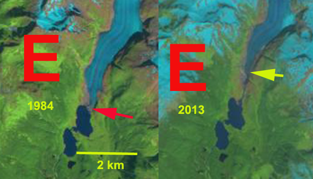
Above is a paired Landsat image from 1984 left and 2013 right indicating the 1100 m retreat during this period of Eagle Glacier.
My first visit to the Eagle Glacier was in 1982 with the, ongoing and important, Juneau Icefield Research Program, that summer I just skied on the glacier. In 1984 we put a test pit at 5000 feet near the crest of the Eagle Glacier to assess the snowpack depth. This was in late July and the snowpack depth both years was 4.3 meters, checking this depth in nearby crevasses yielded a range from 4-4.5 meters.In 1984 the snowline at the end of the summer melt season in early September was at 1050 meters.The equilibrium line altitude (ELA) which marks the boundary between the accumulation and the ablation zone each year. On Eagle Glacier to be in equilibrium the glacier needs to have an ELA of 1025 meters. In the image below the glacier is outlined in green, the snowpit location is indicated by a star and the snowline that is needed for the glacier to be in equilibrium at 1025 meters is indicated. The number of years where the ELA is well above 1050 meters dominate since 2002, all but two years see chart below, leading to mass loss, thinning and glacier retreat. This follows the pattern of Lemon Creek Glacier that is monitored directly for mass balance, which has lost 26 meters of thickness on average since 1953.The more rapid retreat follows the pattern of more negative balances experienced by the glaciers of the Juneau Icefield (Pelto et al. 2013). The high snowlines have left the western most tributary with no retained snowpack in 2013, 2014 and 2015, yellow arrow in the 2014 and 2015 Landsat image. This will lead to the rapid downwasting of this tributary.
Eagle Glacier has experienced a significant and sustained retreat since 1948 when it terminated near the northern end of a small lake. By 1982 when I first saw the glacier and when it was mapped again by the USGS the glacier had retreated to the north end of a second and new1 kilometer long lake. In the image below the red line is the 1948 terminus, magenta line the 1982 terminus, green line 2005 terminus and orange line the 2011 terminus. From 1984 to the 2005 image the glacier retreated 550 meters, 25 meters/year. From 2005-2015 retreat increased to 60 meters/year. Going back to the 1948 map the terminus in 2011 is located where the ice was 150-175 m thick in 1948. The high snowlines in 2014 and 2015 along with extended melt season continued the rapid retreat. Total retreat from 1984-2015 is now 1200 m. The retreat hear is less rapid than on nearby Gilkey Glacier or Antler Glacier, but the upglacier downwasting is more severe than at Gilkey Glacier.

Snowline location and snowpit location in 1984
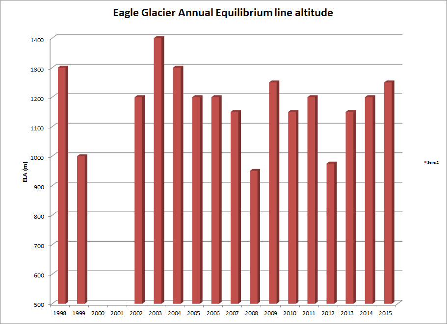
ELA of Eagle Glacier from Landsat images.
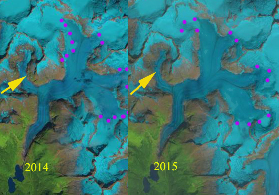
2014 and 2015 Landsat image indicating snowline on Eagle Glacier, purple dots. Yellow arrow indicates tributary that lacks any retained snowpack,

Terminus change map on 2005 Google Earth image. Red line is 1948, magenta line is 1982, green line is 2005 and orange line is 2011.


