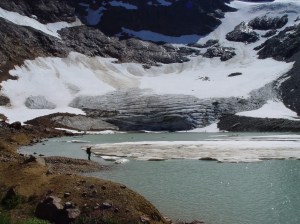
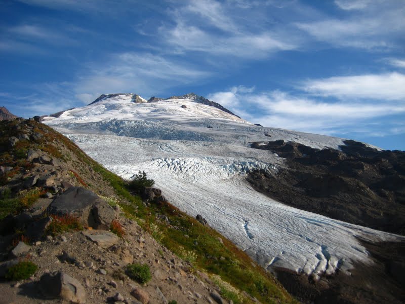
This video examines the 2009 North Cascade Glacier Climate Project Field Season. It is a look more at where we work, than what we find. Mass balances were substantial averaging -1.93 m. The winter season was wetter than average, with close to average snowpack in the North Cascades. Summer melt conditions were exceptionally warm, leading to enhanced melting and considerable losses in glacier volume. The mass loss of approximately 2 meters represents about 4% of total glacier volume, gone in one year. In July ablation averaged 8.5 cm per day. For glaciers that average 50-60 m in thickness that is the loss of 2.5 m in one month. Most of the melt was snowpack from the previous winter. However, by mid-August blue ice was exposed on the majority of the glacier surfaces across the North Cascades and any ablation was a loss in long term glacier volume. In the case of Columbia Glacier at the end of August a view of its surface indicates only a few white patches of snow remaining.  Glacier retreat was slowed on Rainbow and Ice Worm glaciers where the terminus was buried under avalanche snow. Retreat of Easton Glacier was 20 m, Lower Curtis Glacier 11m, Daniels Glacier 12 m, Lynch Glacier 8 m. All 42 glacier observed retreated in 2009. Easton Glacier developed a new rock outcrop in the midst of the glacier
 . More details on this project North Cascade Glacier Climate Project
[url=http://www.youtube.com/watch?v=DJGQXlvWXy8]
Tag: Glacier retreat
Bugaboo Glacier, British Columbia Retreat
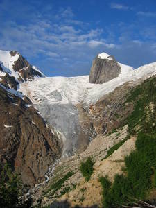
Bugaboo Glacier is the most visible glacier of the Bugaboo Range in southern British Columbia. The Conrad Kain Hut who was the first mountaineer to explore the range is adjacent to the glacier and is the main starting point for climbers lured to the region by the fantastic quartz monszonite spires. Since Conrad Kain’s visit in 1910 with the famous mountain explorer Tom Longstaff the Bugaboo Glacier has retreated 2150 meters. The glacier continues to flow around both sides of Snowpatch Spire, the aptly named peak surrounding by the glacier on the left side of the glacier. Also notice the glacier width declines as it descends past a prominent ridge trending toward the glacier from the right, before expanding in the valley below. 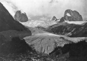 The glacier used to flow all the way to the valley bottom. The active front was both steep and crevassed By the early 1970’s the glacier had retreated from the valley bottom and had begun to retreat up the mountain slope adjacent to the Kain Hut. Snowpatch Spire is still surrounded by ice, but ice that is not as crevassed, indicating reduced thickness and velocity. The glacier than ended somewhat below where the ridge approached from the right of the glacier.
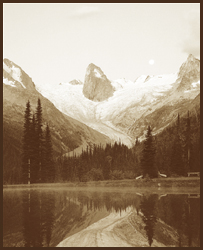 In the ensuing 34 years the glacier has continued to retreat up the slope and is notably thinner coming down the final steep slope. The glacier ends at the termination of the ridge on the right of the glacier. The glacier has retreated 420 m since 1972.
  . The first view is nearly identical to the 1972 view and the second more similar to the 1910 view
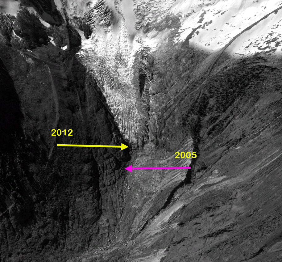
 A Google Earth image from 2005 of the terminus region indicates that the lower 700 meters of the current glacier is thin and lacks any crevasses indicating it nearly stagnant. By 2012 the terminus had retreated 80-90 m from 2005, yellow arrow indicates 2012 terminus, pink arrow 2005. This is in contrast to an active front, which indicates a healthy glacier, that would be thick and crevassed. A healthy glacier can still be retreating, the front was active at the time of my first visit to the glacier in 1984. The glacier is still 3.5 kilometers long and even after the retreat the glacier will still have a substantial length and area.
Honeycomb Glacier Retreat, New Lake Formation
Honeycomb Glacier is one of the longest and largest glaciers in the North Cascades. It is currently 3.7 km long and has an area of 3.1 km2. It has retreated 2.05 kilometers since its Little Ice Age Maximum. The glacier was an imposing site to C.E. Rusk who recounted his early 20th century exploration (1924). Like all 47 glaciers observed by the North Cascade Glacier Climate Project it has retreated significantly since 1979.
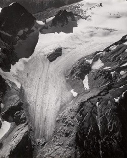
A 1960 photograph taken by Austin Post shows the glacier ending with no lake at its terminus. The terminus is gentle and has no crevasses, indicating it is relatively stagnant and poised to melt away. The glacier has retreated 1.3 km from its Little Ice Age moraines at this point. In 1967 another Austin Post image indicates a new small lake forming at the terminus.
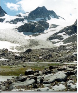
 In 1995 we visited the margin of this lake, where the glacier ended in 1967 and took a photograph back to the glacier. As seen below retreat to this point was 400 m.
  A pair of images from Bill Arundell in 1973 and Lowell Skoog in 2006 indicate the scale of the retreat, these images do not show the actual terminus but do show the main nunatak-rock island and how much it has become exposed in the 33 years. This nunatak was hardly evident in 1960, and in a 1940 image of the glacier literally did not yet exist.
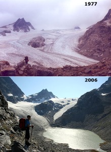 The terminus had retreated 400 m from the 1967 position to 1995. In 1987 a new lake began to form at the terminus of the glacier at 1680 m. The glacier is shown ending in this lake in 2002 from both the far end of the lake and the nunatak above the lake, the glacier had retreated 210 m since 1995. In 2006 the glacier retreated from the end of this lake. This is a shallow lake that may eventually be filled in by glacier sediments. The terminus is flat and stagnant ending at 1680 m in the lake. Thus, the rapid retreat will continue, the glacier is still not close to acheiving a post LIA equilibrium. Glacier retreat from 1940-1967 averaged 9 m/year. Retreat was minor between 1967 and 1979. The retreat rate since 1979 has been greater than 38 m/year, with a total retreat of 700 m. The nunatak in the middle of the glacier, which was beneath the ice in 1940 is now 90 m above the ice. The section of the glacier below the nunatak in 2002 is stagnant with no crevasses.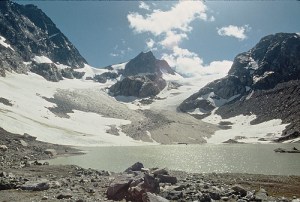
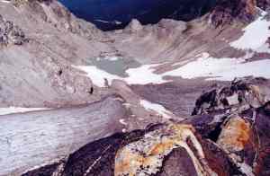 Indicating this glacier will retreat at least to the base of this rock knob, which will then no longer be a nunatak. A comparison of Google Earth Imagery from 1998 and 2009 illustrate the appearance of numerous new bedrock knobs in the area where there was an icefall in 1995.
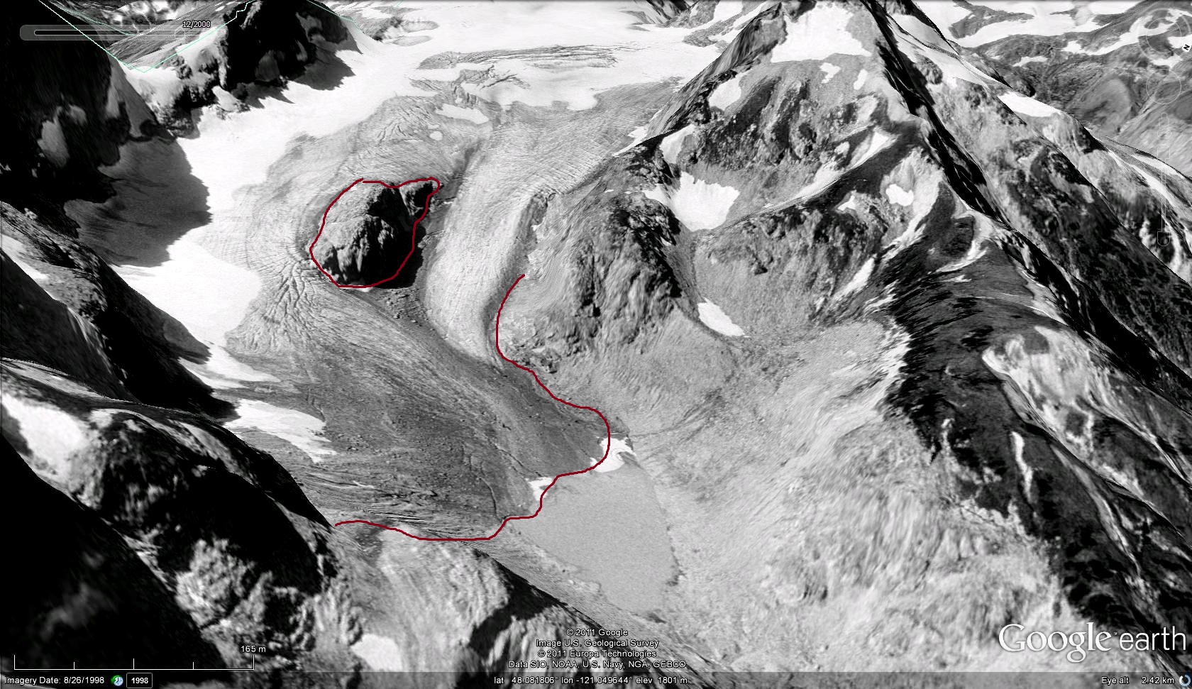
 survive The upper portion of the glacier has retained its snowcover in recent years indicating the glacier can survive current climate at a much smaller size.
Dramatic Retreat of Antler Glacier, Alaska

Above is a pair of Landsat images from 1984 and 2013 indicating the 2600 m retreat of Antler Glacier in that period. Below is a detailed analysis of the glacier.
The Antler Glacier is an outlet glacier of the Juneau Icefield. It is actually a distributary glacier of the Bucher Glacier. It splits from the Bucher Glacier 8.5 km above where the Bucher Glacier joins the Gilkey Glacer as a tributary. In 1948 it spilled over the lip of the Antler River valley from the Bucher Glacier and flowed 6 kilometers downvalley to end in a proglacial lake. The glacier was 6200 m long in 1948. Note the comparison of the USGS map based on 1948 photographs and the 2005 satellite image below. 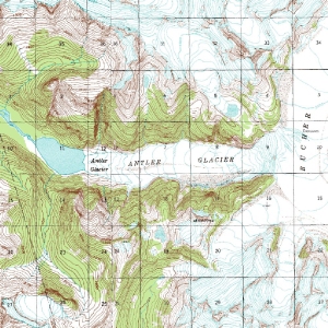
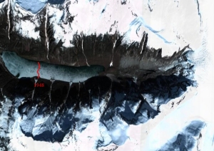 My only chance to see this glacier in person was in August, 1981 scouting the geology along the Bucher Glacier. Antler Glacier disappeared downvalley into the fog and light snow flurries. The terminus not in site, and icefall to daunting to wish to descend. By 2005 the glacier has retreated almost to the lip of the valley, a 5400 m retreat which is 85-90% of it total length. The Lake -Antler Lake- has expanded from a length of 1.6 km to 4.2 km. The lake is a gorgeous sight, and the valley once filled by the glacier is now nearly devoid of glacier input.
 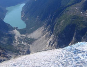 The retreat is largely a result of reduced flow from the thinning Bucher Glacier which no longer spills over the valley lip significantly. As the Bucher Glacier continues to thin, the Antler Glacier will cease to exist. This thinning is due to increased melting (ablation) of the glacier. The neighboring glaciers Field and Gilkey Glacier have also thinned and retreated considerably.
Peridido Glacier Retreat
The Peridido Glacier, Pyrenees Mountains, Spain has lost 92% of its area since 1894. The glacier lost 50% of its area declining from 90 hectares to 44 hectares from 1991 to 2001. Pyrenees Glacier report, written by a group of scientists including Enrique Serrano from the Universidad de Valladolid and Eduardo Martínez de Pisón from the Autónoma de Madrid has noted the loss of 50-60% of the entire area of Pyrenees Glaciers since 1990. The images of Peridido Glacier from 1898 and 1910 were provided by Eduardo Blanchard. In 1910 as seen in the picture below right, the glacier has three sections each connected. The upper section connected with the mid section by a narrow crevassed icefall, the crevasses indicate active movement. The middle section is connected to the lower avalanche fed section by a wide crevassed icefall. The lower section is not heavily crevassed and has thinned and pulled back from the terminus moraine of the Little Ice Age. This moraine is the sediment ridge in the foreground. By 1998 there is no connection between the three sections, the lower section is nearly gone, with just a bit or relict ice. There are very few crevasses indicating a lack of active movement. The glacier is melting more or less in place. The Pyrenees have experienced a 0.9 C degree warming since 1910.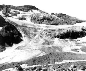

Peridido Glacier is rapidly disappearing, at the current rate of area loss it cannot survive to 2050, and more likely not until 2030. It is not alone in the Pyrenees, at least three glaciers have disappeared in the last 15 years, Balaitus, La Munia and Perdigurero.
Lyman Glacier a Century of Change-Years Numbered
This blog will focus glacier by glacier on the changes that are resulting from climate changes. Each has a unique story, yet there will be a recognizable refrain. Lyman Glacier, North Cascades, Washington retreated 1300 m from 1907 to 2008. Below is the glacier viewed from near Cloudy Pass in 1921 on a Mountaineers expedition and in 2005.
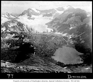
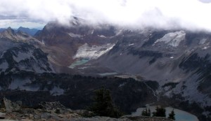
This 76% loss in length has been accompanied by a 88% loss in area and a 91% loss in glacier volume. I first visited the glacier in 1985, and have since been to the glacier on 15 occasions, twice with Bill Long, who first visited the glacier in 1940, measuring its terminus position then. The glacier currently ends in a beautiful expanding glacier lake, with an impressive ice cliff that is 40 meters high, 26 meters above the water. This aids in the retreat as the glacier does calve icebergs occassionally. The rate of retreat is 11 meters per year, for a glacier that is 440 m long, this gives the glacier 40 years at the current retreat rate. The glacier is losing area at a rate of 4% per year, giving it 25 years to survive. Volume loss is between 4 and 5% per year, giving the glacier 20-25 years to survive. By any measure with current climate Lyman Glacier will not survive to 2050. For this glacier the warmer summers since 1977 and the reduced snowpack due to more winter rain events has hastened its decline. The glacier is near a snow measurement station of the US Dept. of Agriculture, which indicates an 18% decline in mean April 1 snowpack since 1945, despite a small rise in precipitation. The glacier is no longer large, but still has considerable thickness, up to 50 m. This particular glacier has not approached equilibrium since the end of the Little Ice Age. Its loss has been hurried along by the recent warming. Even small glaciers take a long time to fully melt away.[url=http://www.youtube.com/watch?v=SiJzgiKReZI]