Hindle Glacier Retreat Causes Rapid Opening of Fjord, South Georgia

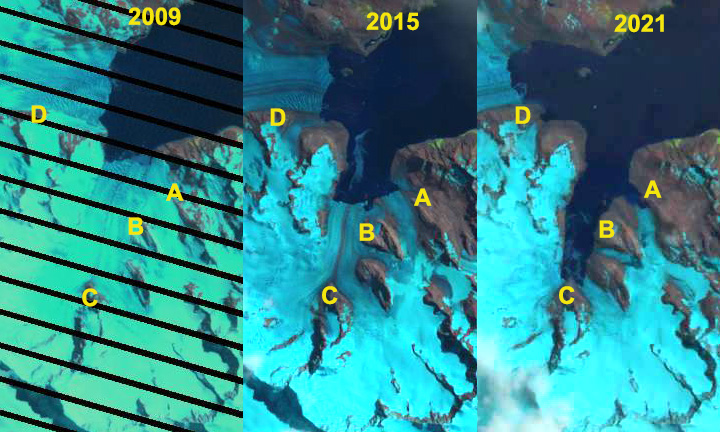
Hindle Fjord opening comparison in 2009, 2015 and 2021 Landsat images.  Point A is the northern tributary, Point B the middle tributary, Point C separates the eastern and western tributary and Point D is Ross Glacier.

Hindle Glacier enters Royal Bay on the east coast of South Georgia Island.  The British Antarctic Survey (BAS) has been the  examining glacier change on South Georgia Island, Cook et al (2010) noted a pattern island wide with many calving glaciers having the fastest retreat.  Alison Cook (BAS) identified that 212 of the Peninsula’s 244 marine glaciers have retreated over the past 50 years and rates of retreat are increasing.  In 2017 we examined Landsat imagery from 1989 to 2017 to identify the rapid retreat rate of Hindle Glacier. NASA Earth  piggy backed on this assessment, with excellent imagery, since the retreat rate has increased. Here we focus on the formation of the fjord from 2009-2021.

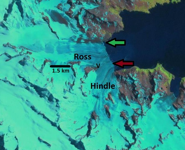
For Ross-Hindle Glaicer in 1989 the glaciers joined 2.5  km from the terminus spanning Royal Bay with a 3.2 km wide calving front.  By 2001 the glacier front had retreated 800 m, but was still a single joined calving front. By 2009 the glaciers had separated due to an additional retreat of  1.4 km. The Hindle Glacier front was now retreating south up opening a new separate fjord from Ross Glacier.  The calving front in 2009 was 1.6 km wide.  By 2015 a 1.6 km retreat led to the separation of Hindle from the northern tributary, Point A.  From 2015 to 2019 the main terminus retreated another 2.1 km, passed the middle tributary at Point B, to a prominent rock knob, Point C, separating the two main tributaries of the glacier with total retreat of  6.1 km in 30 years, an exceptional rate of over 200 m/year. The western tributary is at the head of the fjord and no longer calves significantly, while the eastern tributary has another 1 km to an increase in slopes that likely is close to head of the fjord. The new fjord is 4.5 km long and averages 1.1 km in width and has an area of 5.5 km2.  The northern tributary near Point A is also still calving and retreating.

This embayment opens up new areas for Gentoo Penguins and Elephant Seals to occupy. There are current colonies in Royal Bay and like at Moraine fjord, these two species are early colonizers of deglaciated terrain (see map below from BAS). In particular the beaches adjacent to the northern tributary, just north of Point B and northwest of Point A are wave protected and low slope.  Levy et al (2016) discuss that the southern Gentoo Penguins tend to remain within the same archipelago year around. They examined DNA from 39 Gentoo at Bird Island, adjacent to South Georgia, and found none were migrants.

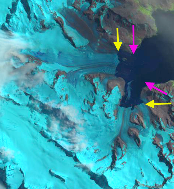
Hindle Fjord in 2020 and 2021 Sentinel images indicating ongoing retreat at Point A and C, with a significant sediment plume from Point B in December 2020. Point A is the northern tributary, Point B the middle tributary, Point C separates the eastern and western tributary and Point D is Ross Glacier.

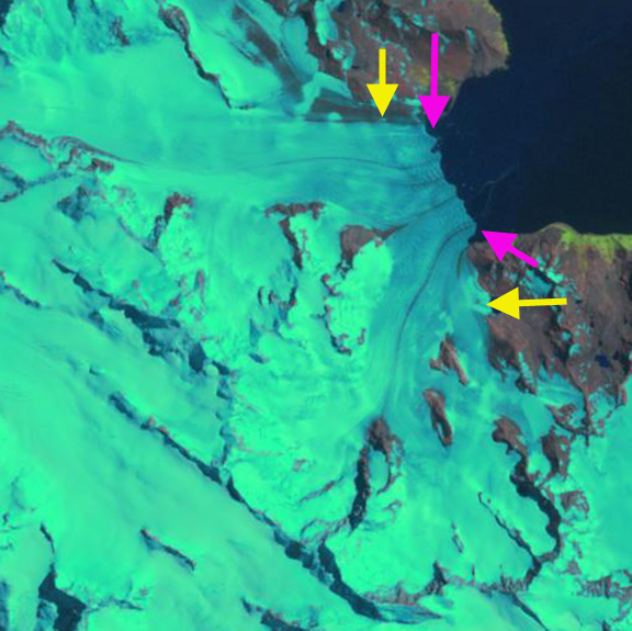
Hindle Glacier comparison in 2001, 2017 and 2019 Landsat images.  The red arrow is the 2001 glacier terminus. Point A is the northern tributary, Point B the middle tributary, Point C separates the eastern and western tributary and Point D is Ross Glacier.

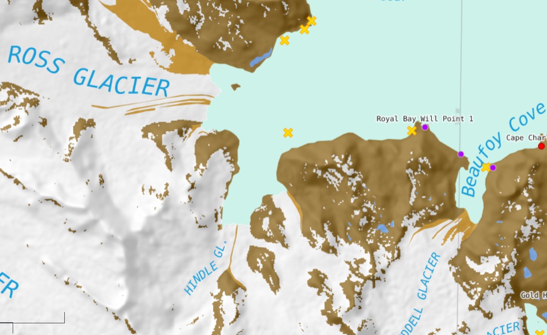
British Anatarctic Survey map of Royal Bay area showing Elephant Seal beaches (yellow X) and Gentoo Penguin colonies (purple dots).

Hindle Glacier Rapid Retreat Continues, South Georgia

Hindle Glacier comparison in 1989, 2015 and 2017 Landsat images.  Red arrow is 1989 terminus, pink arrow the 2015 terminus and red arrow the 2017 terminus location. 

South Georgia is south of the Polar Front preventing any truly warm season from persisting. The cool maritime climate leads to numerous glaciers covering a majority of the island and quite low equilibrium line altitudes.  Hindle Glacier enters Royal Bay on the east coast of South Georgia Island.  The British Antarctic Survey (BAS) has been the principal research group examining glacier change on South Georgia Island.  Cook et al (2010) and Gordon et al (2008) have emphasized that there is a pattern island wide with many calving glaciers having faster retreat.  Gordon et al., (2008) observed that larger tidewater and calving outlet glaciers generally remained in relatively advanced positions from the 1950’s until the 1980s. After 1980 most glaciers receded; some of these retreats have been dramatic and a number of small mountain glaciers will soon disappear.   The change in glacier termini position have been documented by Alison Cook at British Antarctic Survey in a BAS retreat map, she identified that 212 of the Peninsula’s 244 marine glaciers have retreated over the past 50 years and rates of retreat are increasing.   Here we examine Landsat imagery from 1989 to 2017 to identify the rapid retreat rate. NASA Earth has piggy backed on this assessment, with excellent imagery.

For Ross-Hindle the retreat was minimal from 1960 to 1989 with the glaciers joined   In 1989 the glaciers joined 2.5  km from the terminus. The glacier spanned Royal Bay with a 3.2 km wide calving front.  By 2002 the glacier front had retreated 800 m, but they were still joined. By 2008 the glaciers had separated due to an additional retreat of  1.4 km. The front was now retreating south up a separate embayment from Ross Glacier.  The calving front in 2008 was 1.6 km wide.  By 2015 further retreat led to the separation of Hindle from an eastern Tributary at the first prominent headland in the fjord, a 1.6 km retreat in seven years.  By 2017 an additional 600 m of retreat had occurred with total retreat of  4.4 km in 28 years.  This is a rate of over 150 m/year, which is an exceptional rate.  The exceptional retreat rate of Hindle Glacier suggests that Ross Glacier acted as a pinning point stabilizing the terminus reach of the glacier.  The low surface slopes in 2017 for the lowest 3 km of the glacier suggest the fjord head is at least 3 km south of the present terminus and  the calving retreat will continue until the head of the fjord is reached. This location is close to the origin of the medial moraine that runs right to the glacier front currently. This embayment will open up new areas for Gentoo Penguins and elephant seals to immigrate into.  Levy et al (2016) discuss the shift and dispersal of colonies in the region, that climate change is an important driver of.

Map of terminus retreat of Ross and Hindle Glacier from the BAS.  Green Pin Locations are Gentoo Penguin colonies. 

2002 Landsat image of Hindle Glacier.  Red arrow is 1989 terminus and yellow arrow the 2017 terminus location. 

Hindle Glacier 2016 Landsat image.  Red arrow is 1989 terminus and red arrow the 2017 terminus location. 

Location of South Georgia versus atmospheric and ocean circulation features (From South Georgia Future Science). 

Hindle Glacier, Accelerating Retreat, South Georgia

hindle 89-15

Landsat Image of Ross Hindle Glacier 1989 left and 2015 right.  Something changed.

South Georgia sits amidst the furious if not screaming fifties latitude belt, the circum Antarctic westerlies. This region is famous for the endless march of storms parading around Antarctica. The island is south of the Antarctic Convergence, preventing any truly warm season from persisting. The cool maritime climate leads to numerous glaciers covering a majority of the island and quite low equilibrium line altitudes.  Ross-Hindle Glacier enters Royal Bay on the east coast of South Georgia Island has now separated into the Ross and Hindle Glaciers. Hindle Glacier could do well  in a new international Olympic event, “Fastest Retreating Glacier” The tidewater glaciers of South Georgia in general maintained fairly advanced positions unitl 1980. Gordon et al., (2008) observed that larger tidewater and sea-calving valley and outlet glaciers generally remained in relatively advanced positions until the 1980s. For Ross-Hindle the retreat was minimal from 1960 to 1989. The change in glacier termini position have been documented by Alison Cook at British Antarctic Survey in a BAS retreat map.  By 2008 the glaciers had separated. Here we examine Landsat imagery from 1989 to 2015 to identify recent change.

hindle area2

Region of Hindle Glacier on South Georgia.

BAS map of glacier front change.

In 1989 the glacier extends to the green arrows with a joint terminus that is three kilometers long. This is quite close to the 1960 terminus location. By 2003 the glacier has retreated  800 m with the south side nearly reaching a Point where the Hindle Glacier turns south  By 2008 the glaciers have separated, with a further retreat  of 1.5 km along the southern margin of Ross Glacier and western margin of Hindle Glacier. Retreat is much less on the northern side of Ross Glacier and the eastern side of Hindle Glacier.  By 2015 a new fjord has opened, as Hindle Glacier retreats south 1.7 km on the east margin and 2.1 km on the west side in just seven years.Ross Glacier continues to retreat west with a retreat of 600-700 m since 2008.

In Google Earth by 2010 there is  added crevassing near the ice front of Hindle Glacier that indicates an acceleration of the glacier. This suggests the Ross Glacier was impeding its flow previously and that Hindle is in a rapid retreat mode.The rapid recent retreat parallels that of Neumayer Glacier and Twitcher Glacier during the 1989-2014 period. The BAS research effort on glacier front retreat has been documented by Alison Cook . Her comparison of glacier fronts from old aerial photographs and comparing them with satellite images — she identified that 212 of the Peninsula’s 244 marine glaciers have retreated over the past 50 years and that rates of retreat are increasing.

hindle 1989

1989 Landsat Image

ross hindle 2003

2003 Landsat Image


2008 Landsat Image

ross Hindle 2015

2015 Landsat Image