Mendeleevbreen/Øydebreen, Svalbard Terminus Retreat and Snowline Rise

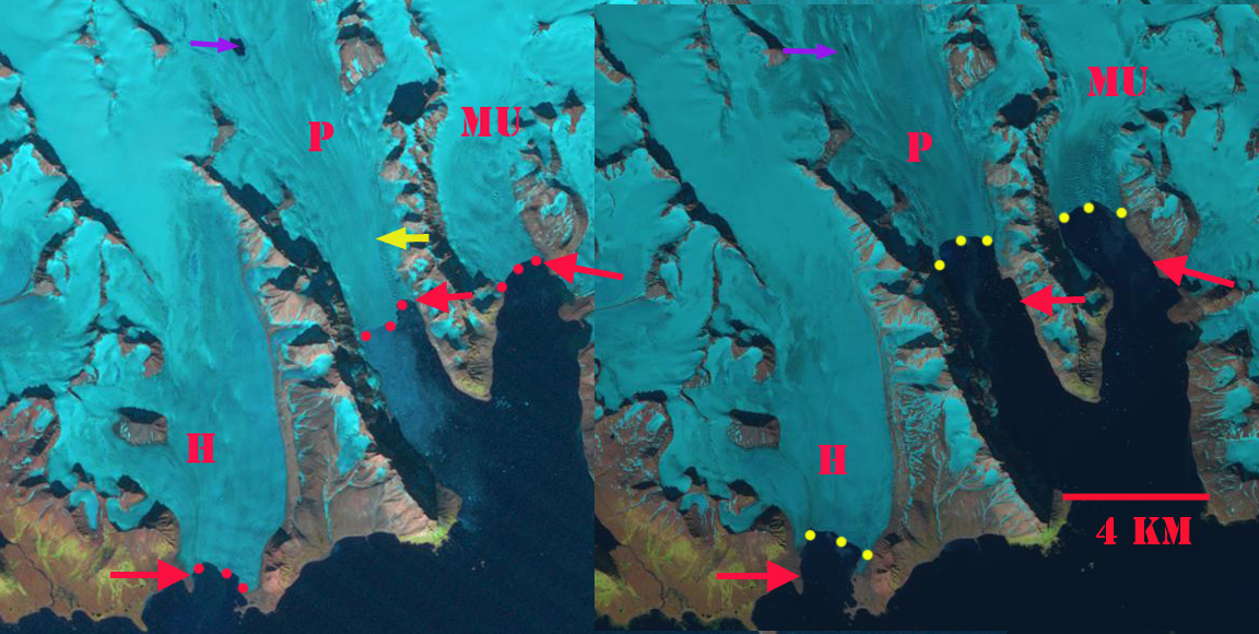
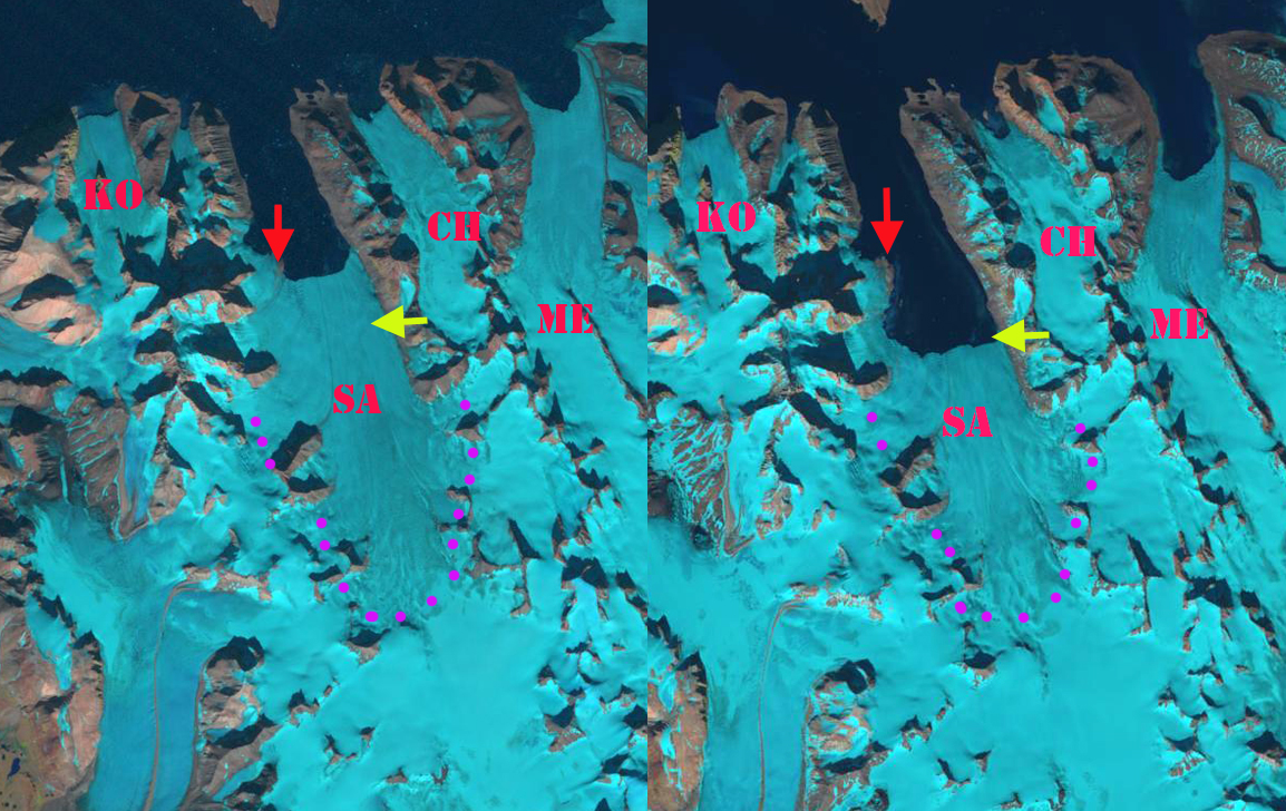
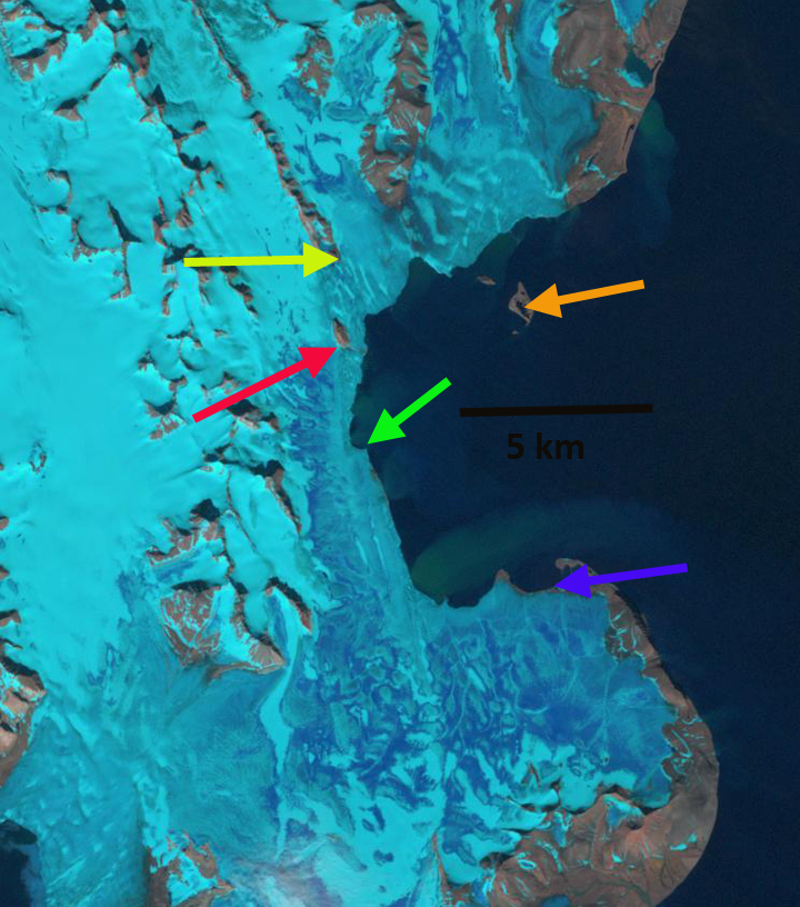
Øydebreen (O) and Mendeleevbreen (M) in 2002 and 2020 Landsat images.  Red arrow is the 1990/2002 terminus, yellow arrow the 2020 terminus and purple dots the snowline.

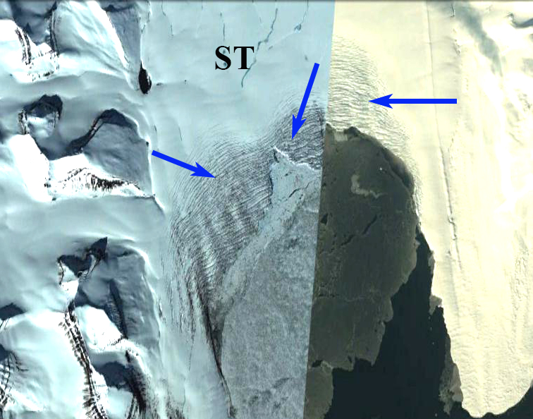
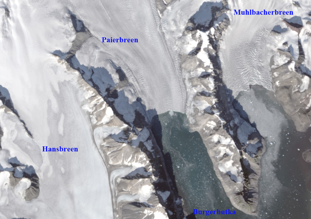
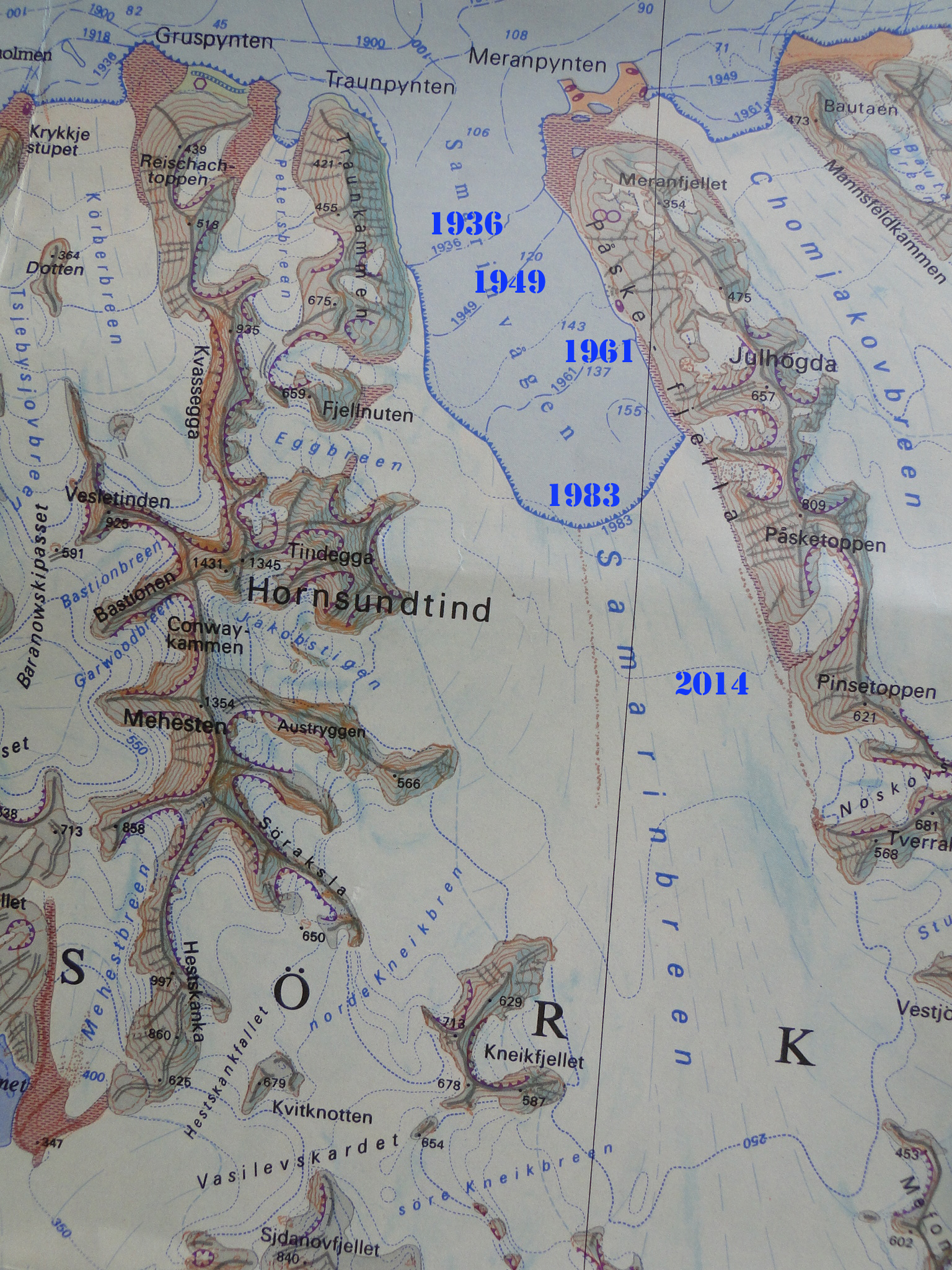
Øydebreen and Mendeleevbreen are a pair of glaciers in Sørkapp Land, Svalbard that a share a divide. Mendeleevbreen flows north to Hornsund and Øydebreen south to Isbutka, meeting at the ice divide at 300 m.  The Institute of Geophysics Polish Academy have maintained a Polish Research Station in Hornsund since 1957. The 1984 map, from the University of Silesia, of the glaciers and geomorphology document the extent of the glaciers in 1983 in the region indicating Mendeleevbreen being connected beyond the northern end of its fjord to its neighbor to the east Svalisbreen.  A detailed examination by Blaszczyk, Jania and Kolondra (2013) reported the total area of the glacier cover lost in Hornsund Fjord area from 1899–2010 was approximately 172 km2. The average glacier area retreat increased from a mean of 1.6 km2/year to 3 km2/year since 2000.  Pelto (2017) reported significant retreat of all 10 major tidewater glaciers of Hornsund Fjord. In the August 4, 2020 image it is apparent that one could walk from the terminus of the Mendeleevbreen over the divide to the terminus of the Øydebreen without encountering snow.

In 1990 the distance from the front of Mendeleevbreen to Øydebreen was ~17.5 km. Øydebreen terminated just east of Fallknatten, a rib of rock separating the glacier from Vasilievbreen. Mendeleevbreen terminates adjacent to a tributary from the east Signybreen. The snowline in the 1990 August Landsat image is at 200 m.  By 2002 Øydebreen has retreated substantially across its entire front.  Jania et al (2006) noted a 400 m advance of  the center of Mendeleevbreen from 1990 to 2004.  The east margin retreated and the west margin was stable during this period, with the overall front position advancing ~100 m. The glacier is known to have surged in the past, and this could have been a small surge event.  The snowline in the August 2002 Landsat image is at 225 m.  By 2014 the distance from the front of Mendeleevbreen to Øydebreen was 13.5 km.  The Mendeleevbreen terminus had retreated to the eastern tributary of Grobreen. The snowline in August 2014 is at ~225 m.  The snowline in August 2015 is at ~200 m.

By August 2020 the distance from the front of Mendeleevbreen to Øydebreen was 12.5 km, a combined retreat of 5 km since 1990.  Øydebreen is now poised to retreat into its own fjord. The snowline at the start of August 2020 is above the 300-m ice divide, leaving the possibility that no snow at all will remain by the end of the melt season on either glacier.  It was noted in early July how high the snowline was on Svalbard glaciers.  The retreat of these two glaciers fits the pattern of Svalisbreen, Samrarinbreen and Vasilievbreen.  Unfortunately the high snowlines of 2020 indicate large mass losses will occur that will only accentuate ice loss.

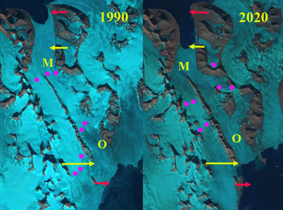
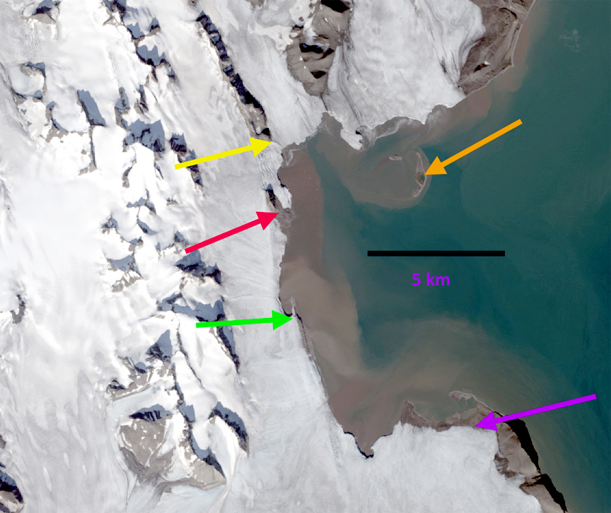
Øydebreen (O) and Mendeleevbreen (M) in 1990 and 2020 Landsat images.  Red arrow is the 1990/2002 terminus, yellow arrow the 2020 terminus and purple dots the snowline.

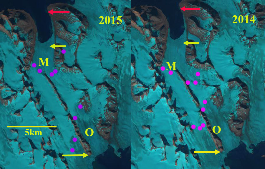
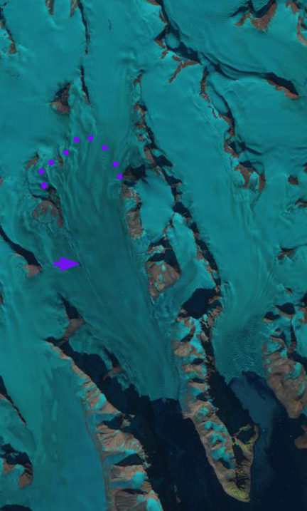
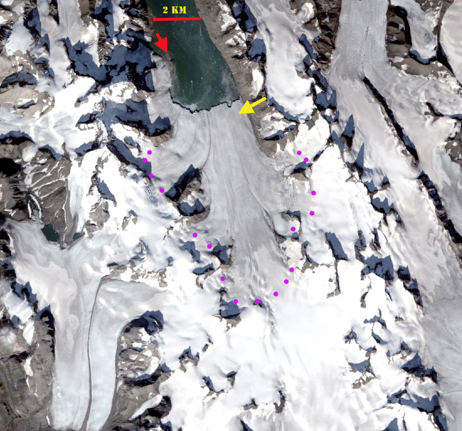
Øydebreen (O) and Mendeleevbreen (M) in 2014 and 2015 Landsat images.  Red arrow is the 1990/2002 terminus, yellow arrow the 2020 terminus and purple dots the snowline.

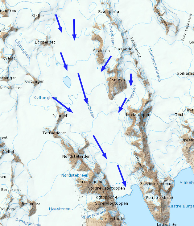
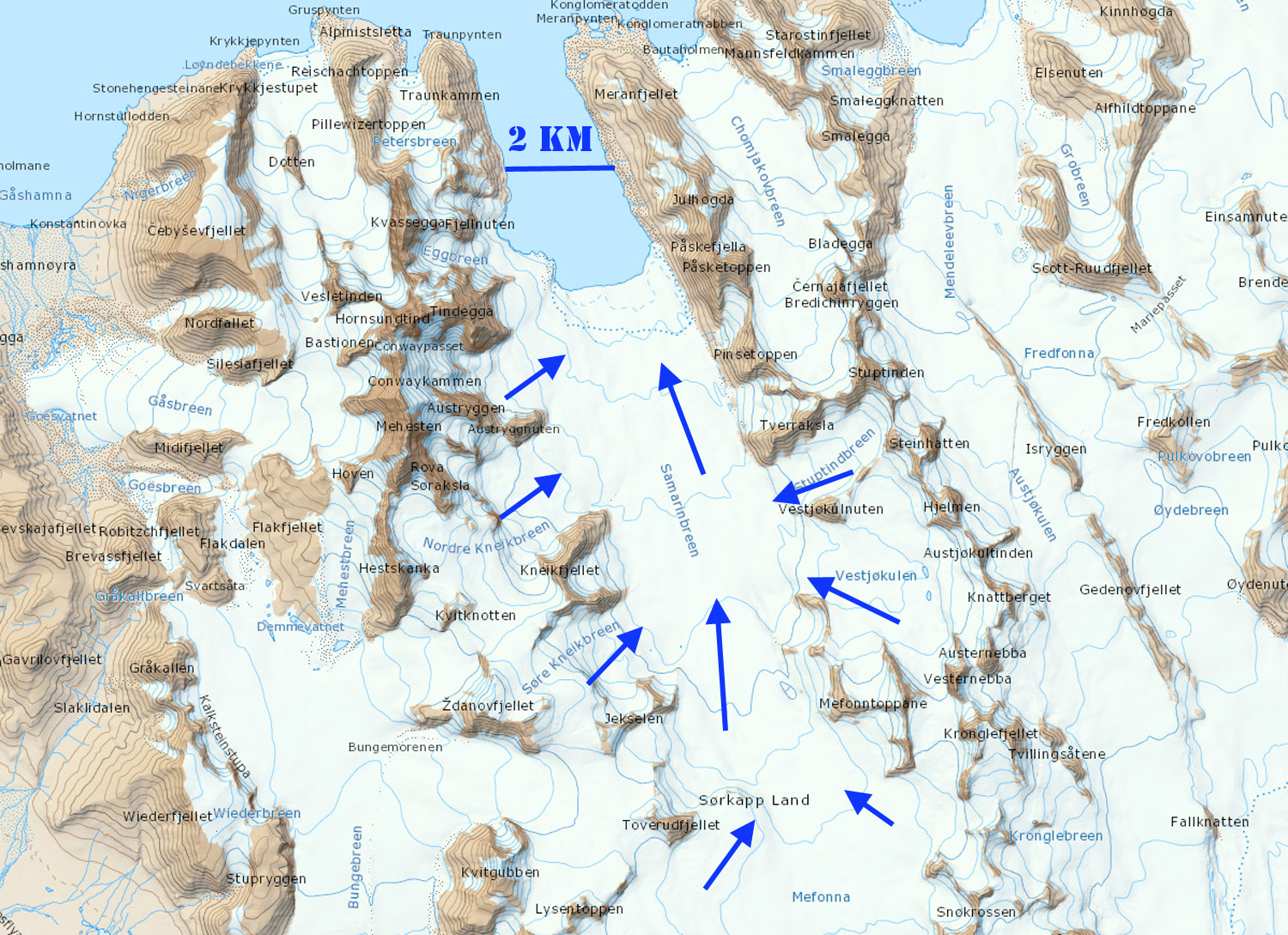
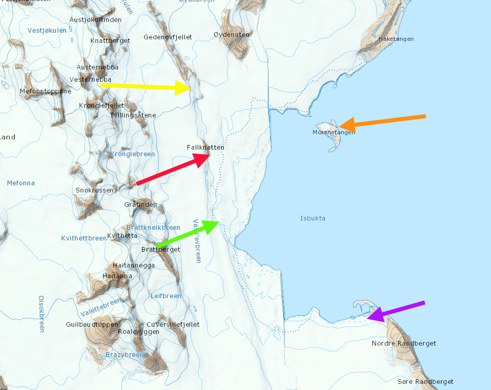
TopoSvalbard map of the region with ice flow indicated by blue arrows. 

Storbreen, Svalbard Major Retreat Opens New Fjord

Storbreen, Svalbard in 1990 and 2017 Landsat images.  The red arrows indicate 1990 terminus , yellow arrow the 2017 terminus and purple dots the snowline in 1990.  A recent snow storm has obscured the actual snowline in Aug 2017. 

Storbreen Glacier (ST) terminates on the north side of Hornsund in southern Svalbard.  From 1990 to 2017 Storbreen has experienced a substantial retreat opening a new fjord and separating from Hornbreen (H).  Svalbard is host to 163 tidewater glaciers with a collective calving front of 860 km Błaszczyk et al, (2009). Nuth et al (2013) determined that the glacier area over the entire archipelago has decreased by an average of 80 km per year over the past 30 years, a 7% reduction. In the most recent period 1990-2007, terminus retreat was larger than in an earlier period from 1930-1990, while area shrinkage was smaller. Hornsund is a fjord that in 2014 almost cuts through the southern Island of Svalbard, and eventually will. The Institute of Geophysics Polish Academy has maintained a Polish Research Station in Hornsund since 1957.  The 1984 map, from the University of Silesia, of the glaciers and geomorphology document the extent of the glaciers in 1983. A more detailed examination by the same researchers, Blaszczyk et al. (2013) reported the total area of the glacier cover lost in Hornsund Fjord area from 1899–2010 was approximately 172 square kilometers. Pelto (2017) reported significant retreat of all 10 major tidewater glaciers of Hornsund Fjord.

In 1990 the terminus of Storbreen on the east side is shared with Hornbreen Glacier (H), joining near the tip of a peninsula that will emerge between the glaciers with retreat.  On the west side the glacier terminates at the southern end of a peninsula.  The snowline is at 400 m in 1990.  In 2002 the glacier has separated from Hornbreen and terminates in a newly opening fjord, with the snowline at 350 m.  In 2013 and 2015 the glacier has retreated substantially up the new fjord with the snowline at 450 m in 2013 and 500 m in 2015.  By 2017 the glacier has retreated 8.7 km in the glacier center from the west margin in 1990, 6.0 km on the centerline and 4.8 km from the east margin of 1990.  The glacier terminus is still tidewater and is 4.7 km wide.  The extensive crevassing at the glacier front in Google Earth imagery, below, indicates continued rapid flow at the terminus.  The retreat continues with significant cahnge after 2013.  The crevassing may indicate a steeper surface slope too.  The topography at TopoSvalbard suggests limited change in surface slope based on older mapping.  The head of the fjord is not likely to occur until at least the junction point of several tributaries. The retreat here is similar to that of adjacent Hornbreen and Paierbreen.

Storbreen, Svalbard in 2013 and 2015 Landsat images.  The red arrows indicate 1990 terminus , yellow arrow the 2017 terminus and purple dots the snowline.   

The crevassed front of Storbreen in 2014 on left.  Indicating active calving but also suggestive of a steeper slope than before.  The Fjord head does not appear to be near though. 


Storbreen, Svalbard in 2002 Landsat image.  The red arrows indicate 1990 terminus , yellow arrow the 2017 terminus and purple dots the snowline. 


Paierbreen Rapid Calving Retreat, Svalbard

paierbreen compare
1990 and 2014 Landsat images indicating Paierbreen (P), Muhlbacherbreen (MU) and Hansbreen (H). The red arrow and red dots indicate the 1990 terminus location and yellow arrows and yellow dots the 2014 terminus location. The purple arrow indicates the location of a supraglacial lake that was persistent in the 1990’s but is no longer evident in 2013, 2014 and 2015.

From 1990 to 2014 all four of the glaciers terminating along the north coast of Hornsund have retreated significantly: Hansbreen (H), Paierbreen (P), Muhlbacherbreen (MU), Storbreen. Svalbard is host to 163 tidewater glaciers with a collective calving front of 860 km (Błaszczyk et al, 2009). Nuth et al (2013) determined that the glacier area over the entire archipelago has decreased by an average of 80 km2 per year over the past 30 years, a 7% reduction. In the most recent period 1990-2007, terminus retreat was larger than in an earlier period from 1930-1990, while area shrinkage was smaller. Hornsund is a fjord that in 2014 almost cuts through the southern Island of Svalbard. The Institute of Geophysics Polish Academy has maintained a Polish Research Station in Hornsund since 1957.  The 1984 map, from the University of Silesia, of the glaciers and geomorphology document the extent of the glaciers in 1983. A more detailed examination by the same researchers, Blaszczyk et al. (2013) reported the total area of the glacier cover lost in Hornsund Fjord area from 1899–2010 was approximately 172 square kilometers. This groups ongoing research, Petlicki et al (2015) , identified the impact of a waterline notch that enhances calving at Hansbreen. This study identifies the importance of water temperature and reduced sea ice cover in the fjord.

Paierbreen in 1990 terminated in Burgerbutka with a 1900 meter long calving front. At the purple arrow a supraglacial lake existed that is also seen in the TopoSvalbard Map. The snowline on Paierbreen is further upglacier of the calving front than for the adjacent glaciers indicating a lower surface slope. By 2014 the glacier has retreated 2200 m with the current terminus at a narrow point in the fjord.  Beyond this point the fjord again expands, which will enhance calving and retreat.  There is no significant step in glacier slope indicating where the tidewater limit is, given the low slope, it is not likely close to the current ice front.  The calving front is 1600 m wide in 2014. The supraglacial lake is only a sliver in 2013 and 2014. The snowline in the Landsat image from 2013 is at 450 m. The story of retreat here is the same as at Samarinbreen and Hornbreen
paierbreen 2013
2013 Landsat Image

paierbreen map
Topographic Map from TopoSvalbard

paierbreen aerial
Satellite Image from TopoSvalbard

Samarinbreen, Svalbard Rapid Retreat 1990-2014

samarinbreen compare
Samarinbreen (SA) 1990 left, and 2014 right, Landsat image comparison.  KO=Korberbreen, CH=Chomjakovbreen,
ME=Mendeleevbreen Red arrows indicate 1990 terminus position, yellow arrows 2014 terminus. and purple dots the snowline.

Samarinbreen terminated in a calving front in Samarinvagan, a bay on the southern side of Hornsund Fjord. Hornsund is a fjord that in 2015 almost cuts through the southern Island of Svalbard, due to the retreat of Hamberbergbreen and Hornbreen. The Institute of Geophysics Polish Academy have maintained a Polish Research Station in Hornsund since 1957. The 1984 map, from the University of Silesia, of the glaciers and geomorphology document the extent of the glaciers in 1983 in the region. Blaszczyk et al (2009) analysis identified 163 Svalbard glaciers that are tidewater with the total length calving ice−cliffs at 860 km for the 2001-2006 period. They observed that 14 glaciers had retreated from the ocean to the land over the last 3-4 decades. Nuth et al (2013) determined that the glacier area over the entire archipelago has decreased by an average of 80 km2/year over the past 30 years, a 7% reduction.In the most recent period 1990-2007, terminus retreat was larger than in an earlier period from 1930-1990, while area shrinkage was smaller. A more detailed examination by the same researchers, Blaszczyk, Jania and Kolondra (2013) reported the total area of the glacier cover lost in Hornsund Fjord area from 1899–2010 was approximately 172 km2. The average glacier area retreat increased from a mean of 1.6 square kilometers per year to 3 square kilometers per year since 2000. Samarinbreen begins near the height of land of Sorkappland sharing the divide with Olsokbreen at an elevation of below 400 m.
samarinbreen map
Map from Topo Svalbard
Samarinbreen retreat is documented by the map produced by the University of Silesia; 1936-1949 retreat equals 750 m, 1949-1961 retreat equals 1200 m, 1961-1983 retreat equals 1700 m. Landsat imagery from 1990-2014 illustrates that the retreat of the glacier has been 2.1 km. The 1990 terminus is indicated by the red arrow, and the 2014 terminus is the yellow arrow. The tidewater front shows limited icebergs from calving in all images I have reviewed, yet calving must be a key means of volume loss.   The snowline in 1990 is between 300 m in 1900. In 2014 the image is earlier in the melt season, but is at at 275 m.  The 2012 image of the terminus region illustrates the snowline again near 300 m. There is limited glacier area above 400 m, indicating the high snowfall and low melt rate of the region allowing a glacier to have such a low mean elevation. That the snowline is consistently so close in elevation to the highest section of the glacier indicates that mass loss will continue as will retreat.

samarinbreen silesia map

University of Silesia Map of Hornsund


saraminbreen image
Samrinbreen 2012 image from Topo Svalbard, red arrow indicates new island.

Vasilievbreen Glacier Retreat, Svalbard

Vasilievbreen is a glacier that terminates on the east coast of the southern island of Svalbard a short distance southeast of Hornsund. In 1990 this glacier had a single continuous terminus margin along the coast. The glacier retreated 50 m/year from 1936 to 1990, as the embayment of Isbukta expanded. The glacier has since separated into distinct termini, on each image colored arrows indicate the same specific location, red arrow a developing island named Fallknatten, yellow arrow the tip of peninsula called Gedenovfjellet, the orange arrow an island called Morenetangen, the green arrow an emerging island not evident on the map and the purple arrow an area of new coastline on the south side of Isbukta. Blaszczyk et al (2009) analysis identified 163 Svalbard glaciers that are tidewater with the total length calving ice−cliffs at 860 km for the 2001-2006 period. They observed that 14 glaciers had retreated from the ocean to the land over the last 30–40 year period. One glacier they observed having separated was Vasilievbreen. A more detailed examination by the same researchers, Blaszczyk, Jania and Kolondra(2013) reported the total area of the glacier cover in Hornsund Fjord from 1899–2010 diminished by approximately 172 km2. The average glacier area retreat increased from a mean of 1.6 square kilometers per year to 3 square kilometers per year since 2000. The Polish Polar Station at Hornsund is an ideal location from which to conduct annual field research on the glacier and arctic environment in the area. vasilievbreen placevasil map
Map from TopoSvalbard

Here we use Landsat imagery to examine the changes in Vasilievebreen from 1990-2014. In 1990 the terminus is continuous. The glacier reaches the coastline at the purple arrow. There is no evident land at the green arrow. The terminus approaches quite close to the island at the orange arrow and there is a nunatak surrounded by ice at the red arrow. By 2002 Vasilievbreen is no longer a continuous terminus. The glacier at the purple arrow has retreated from the sea, exposing a narrow strip of coastline. At the green arrow some bedrock has emerged that will become islands. At the orange arrow the glacier has retreated from the vicinity of the island. By 2014 The strip of land at the purple arrow has expanded to a length of 2km and a width of 300-500 m, this is a retreat of 400 m. At the green arrow a 3 km long rib of bedrock is exposed and the glacier has retreated 500 m since 1990. At the red arrow the nunatak of 1990 is now at the terminus of the glacier and is much larger, a retreat of 750 m. At the yellow arrow the end of a peninsula is now much closer to the ocean, a retreat of 900 m. At the orange arrow this moraine based island has been eroding, but is also much further from the glacier, a retreat of 800 m. The glacier now has five distinct terminus segments that can retreat independently of each other. That this retreat occurred along a front that is 20 km long represents a loss in glacier area of approximately 10 square kilometers. This is more significant than the actual distance of retreat. The snowline on the glacier in 2014 is above 300 m with the melt season still going, this leaves most of the glacier in the melt zone. The retreat and changing nature of this glacier paralells that of other glaciers in southern Svalbard: Nannbreen, Olsokbreen, Hornbreen and Hambergbreen.
vasilievbreen 1990
1990 Landsat image

vasilievbreen 2002
2002 Landsat image

vasilievbreen 2014
2014 Landsat image

vasil sat
2010 Image from Toposvalbard

Hornbreen-Hambergbreen Retreat Svalbard

Hornsund is a fjord that in 2010 almost cuts through the southern Island of Svalbard. The Institute of Geophysics Polish Academy have maintained a Polish Research Station in Hornsund since 1957. The 1984 map, from the University of Silesia, of the glaciers and geomorphology document the extent of the glaciers in 1983. At that time the eastern end of Hornsund was fronted by a single glacier terminus comprised of the Sotrbreen (ST), Hornsbreen (HO), Svalisbreen (SV) and Mendelejevbreen (ME). By 2010 retreat has led to the separation of these four glaciers. The top image is the map superimposed on the Landsat image both below, from commenter Andylee. Pälli et al (2003)in a joint University of Oulu, Finland and University of Silesia noted that Hornbreen has retreated by 13.5 km from the central part of the front, and Hambergbreen (HA) by 16km from 1901-2000. As part of this project surveys of the basal topography beneath the glaciers was examined.
Moore et al, 2003) found that there is not a below sea level connection underneath the Hornbreen-Hamberbreen divide that would separate Sorkappland from Torrelland. The ice divide of Hornbreen-Hambergbreen is below the local snowline at 300 m and Pälli et al (2003) indicate that this connection cannot survive current climate. Kvamstø et al (2011) in a Bergen University led study noted the melt season had increased by more than two weeks in Svalbard from 192-2010. In 1983 the distance from the terminus of the Hornbreen to the terminus of Hambergbreen was 17 km. In 2010 the distance is 9 km, as seen below. . A comparison of locations in the 1983 map and the 2010 Landsat image indicate the retreat from 1983 to 2010 has been approximately 5.5 km for Storbreen, 6 km for Hornbreen, 3 km for Svalisbreen and 1.5 km for Mendelejevbreen. . The retreat of the glaciers at the head of Hornsund follow the pattern of other glacier in the region Nannbreen and Hansbreen.

Retreat of Hansbreen, Svalbard

Hansbreen is tidewater glacier flowing into Hornsund in sw Svalbard. The glacier has been examined in detail over the last twenty years from the Polish Research Station. The glacier has retreated 2.7 kilometers from 1900 to 2008. The chart below from Oerlemans, Jania and Kolandara (2011) illustrates this retreat as does the comparative images from the Polish Research Station. The glacier mass balance has been measured since 1989 and is submitted to the World Glacier Monitoring Service. In a detailed review of this calving glacier Oerlemans, Jania and Kolandra (2011) report that The average surface mass balance has been -0.36 meters per year, but this is equaled by the calving loss, leading to a loss of 0.8 meters per year. The low slope of this glacier 1.6 degrees makes it difficult to reestablish equilibrium as it retreats. The bed of the glacier remains below sea level for at least 70% of its length, note Figure 3 in Oerlemans et al (2011). The glacier retreated 400 meters from 2000-2005, and has continued this rate of recession. In the two side by side Landsat images below from 2001 (right) and 2010 (left) changes are evident at the front of the neighboring Paierbreen-circle, Hansbreen (H) and Nannbreen (A) Focusing just on the Hansbreen a red line from the summit of two adjacent mountains is added to the 2001 and 2010 image to illustrate the terminus change. The 2001 images is on top, 2010 image below.