Kokthang Glacier Retreat, Sikkim Himalaya, India Doubles Lake Size

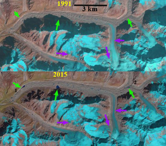
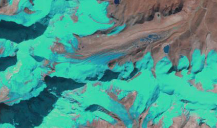
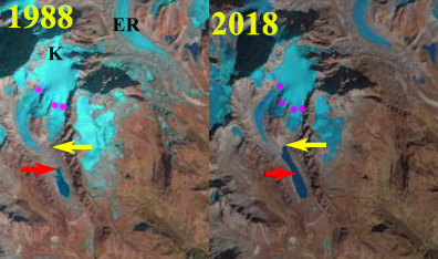
Kokthang Glacier in 1988 and Feb. 2018 Landsat imagery. The red arrow indicates the 1988 terminus and the yellow arrow the upstream end of the lake beyond which the glacier has retreated in 2018.  The purple dots indicate the snowline. 

Kokthang Glacier drains south from the Kokthang Peak a satellite peak on the south side of the Kanchenjunga Massif, Sikkim in India, the next valley south of East Rathong Glacier. This glacier drains into the Rangit River, which hosts a 60 MW run of river Rangit Hydropower project.  Here we examine changes in the glacier from 1988 to 2018. Glaciers draining east from Kanchenjunga have generally experienced substantial retreat and lake expansion (Govindha Raj et al 2013): Lhonak Glacier, Changsang Glacier etc.  The exception being Zemu Glacier which has been thinning, but not retreating substantially. NASA Earth Observatory posted an article based on this blog post.

In 1988 the debris covered terminus was in a 800 m long proglacial lake, after the two main tributaries joined.  The snowline was at 5500 m. In 2000 the lake has expanded significantly and only the western tributary is actively reaching the lake.  The snowline in 2000 is at 5400 m.  By 2005 glacier retreat of the stagnant tongue had led to a lake expansion to a length of 1300 m, Google Earth image on left below.  The snowline in 2005 is at 5500 m.  The eastern tributary no longer descended to the lake. By 2017 the lake had further expanded to a length of 1600 m.  The glacier retreat over the 30 year period being greater than the 800 m that represent a doubling of the proglacial lake size.  The glacier has now effectively retreated from the lake and only minor expansion will occur with ice cored moraine meltout. The snowline in October 2017 was at 5600 m. The snowline remained high from October to mid-winter as it had in most recent years, with the February 2018 snowline at 5600 m still.  This illustrates that ablation albeit, at a slow rate, is occurring from October-mid winter.

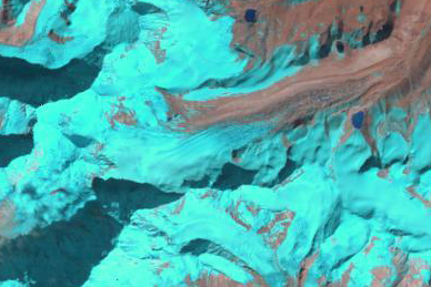
The persistent high snowline through much of the year leads to continued thinning and retreat of the lower glacier. The high snowlines have been seen in the Mount Everest area and on Gangotri Glacier.  The upper glacier continues to retain snowcover indicating the glacier can survive current climate.


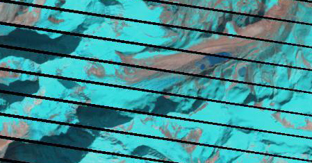
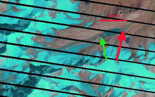
Kokthang Glacier in 2000 and 2017 Landsat imagery. The red arrow indicates the 1988 terminus and the yellow arrow the upstream end of the lake beyond which the glacier has retreated in 2018.  The purple dots indicate the snowline. 

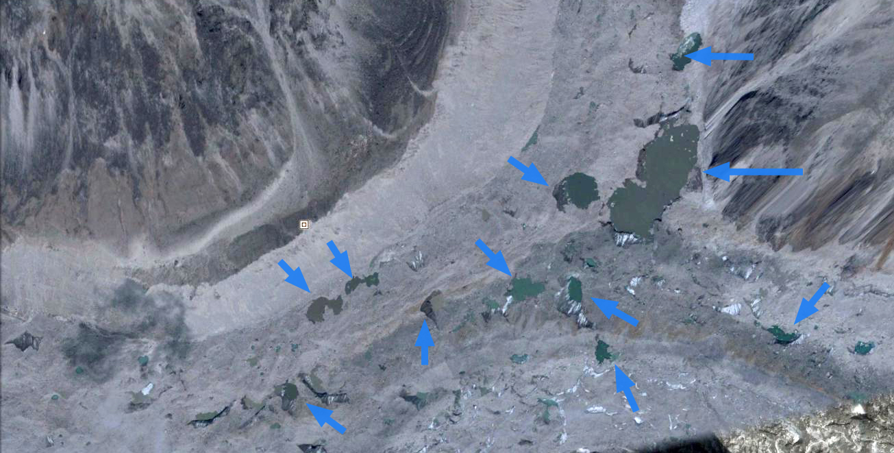
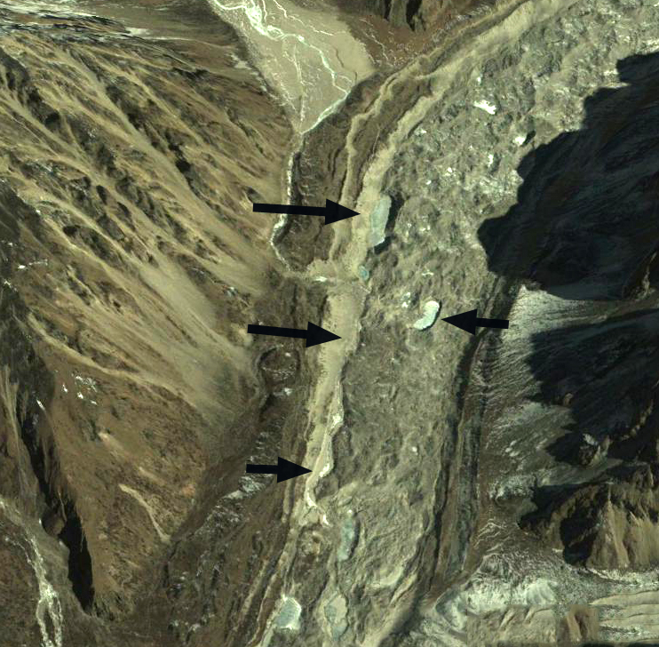
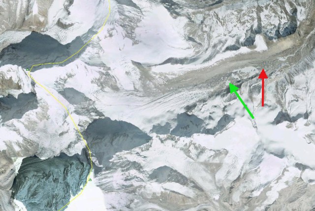
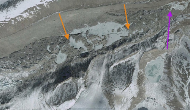
Google Earth imagery from 2005 and 2014 of Kokthang Glacier. 


Kanchenjunga Glacier, Nepal Volume Losses

kanchenjunga compare
Figure 10-16. Kanchenjunga Glacier (K) from 1991 to 2015, green arrows indicate locations of enhanced supraglacial lakes since 1991. Purple arrow indicates areas of thinning at higher elevations in the region. Location 2 is the main junction area. 

Kanchenjunga Glacier is the main glacier draining west from Kanchenjunga Peak, also listed on maps as Kumbukarni. The glacier is similar to Zemu Glacier flowing east from the same mountain into Sikkim, in the heavy debris cover that dominates the glacier in the ablation zone extending from the terminus for 15 km and an altitude of 5600 m. Identifying the retreat is difficult due to the debris cover. Racoviteanu et al (2015) examined glaciers in this region using 1962 and 2000 imagery. They found area losses of 14% for debris covered glacier and 34% for clean glaciers. The debris covered glaciers terminus response is even more muted indicating why terminus change is an easy measure of glacier change but not always the best. For Kanchenjunga Glacier Racoviteanu et al (2015) indicate the glacier area declined by just 4-8% from 1962-2000.

What is apparent in the Landsat images at the green arrows is the increase from 1991 to 2015 of supraglacial lakes. Also features of thinning are evident in the mid reaches of the glacier, purple arrows, where tributaries have narrowed and detached from the main glacier. A closeup of the main glacier junction 12 km above the terminus indicates the number of large supraglacial lakes. These cannot form in a region where melting does not dominate over glacier motion. The Google Earth image from 2014 of the terminus area indicates a patchwork of moraine cored ice dotted with supraglacial lakes and dissected by the glacial outlet river in the lower 3 km of the glacier. This is clearly not an active portion of the glacier, it is thin not moving and does not fill even the valley floor. An overlay of images indicates the lack of motion. The heavy debris cover has slowed retreat and thinning, however, the lower glacier is poised for an increased rate of retreat with merging of supraglacial lakes, which will lead to further area losses. The Kanchenjunga Glacier is losing volume like all other 41 glaciers examined in detail and linked at the Himalayan Glacier Index page. 

kanchenjunga glacier jct

Google Earth image of the main glacier junction region (2) Supraglacial lakes in the area of at 5200 m. 


kanchenjunga glacier

Google Earth image of supraglacial lakes 2-5 km above the terminus and the region along the north margin of the glacier where the glacier is receding from the lateral moraine. 

kanchenjunga terminus

2014 Google Earth image of terminus reach.  Black arrows indicate ice cored moraine, blue arrow the lowest large supraglacial lake, 2.5 km above the terminus and red arrow the last remnant of ice. 

Changsang Glacier Retreat and Lake Formation, Sikkim

Changsang Glacier is a valley glacier just north of Kanchengjunga, the third highest peak, in Sikkim. A comparison of Landsat imagery from 1989 to 2012 identifies the formation of a lake at the end of the glacier. The red arrow indicates the downvalley end of the lake that will develop, the green arrow the upvalley end. In 1989 there is no evidence of a lake either on top of the glacier, supraglacial or proglacial, at the end of the glacier. In 2000 there are a several small lakes beginning to develop. In the 2006 Google Earth imagery the lake is 700 meters long with several other developing smaller lakes. By 2011 the main lake is 1000 meters long and has one debris covered ridge that separates it from a second lake. By 2012 the lake has expanded incorporated the second lake and is now 1500 meters long. The Changsang Glacier was reported to be retreating 22 m/year from 1976 to 2005 (Raina, 2009). In Sikkim 26 glaciers examined were retreating at an average rate of 13.02 m per year from 1976 to 2005 (Raina, 2009) is following the same path as South Lhonak Glacier just to the north and Zemu Glacier just to the south. Zemu Glacier to the south is fed by a higher accumulation zone, and has not been retreating as fast, but it should be anticipated that a lake will form near its terminus.

changsang1989
changsang 2000

changsang 2006 ge

changsang 2011
changsang 2012

A closeup view of the terminus area in 2006 indicates the main lake and several smaller lakes that will join the main lake by 2012. The purple arrow indicates the outlet river from beneath stagnant debris covered ice. The orange arrows indicate the extent of the developing lake by 2012.
changsang terminus