Mendenhall Glacier, Alaska Accumulation Zone Shrinks

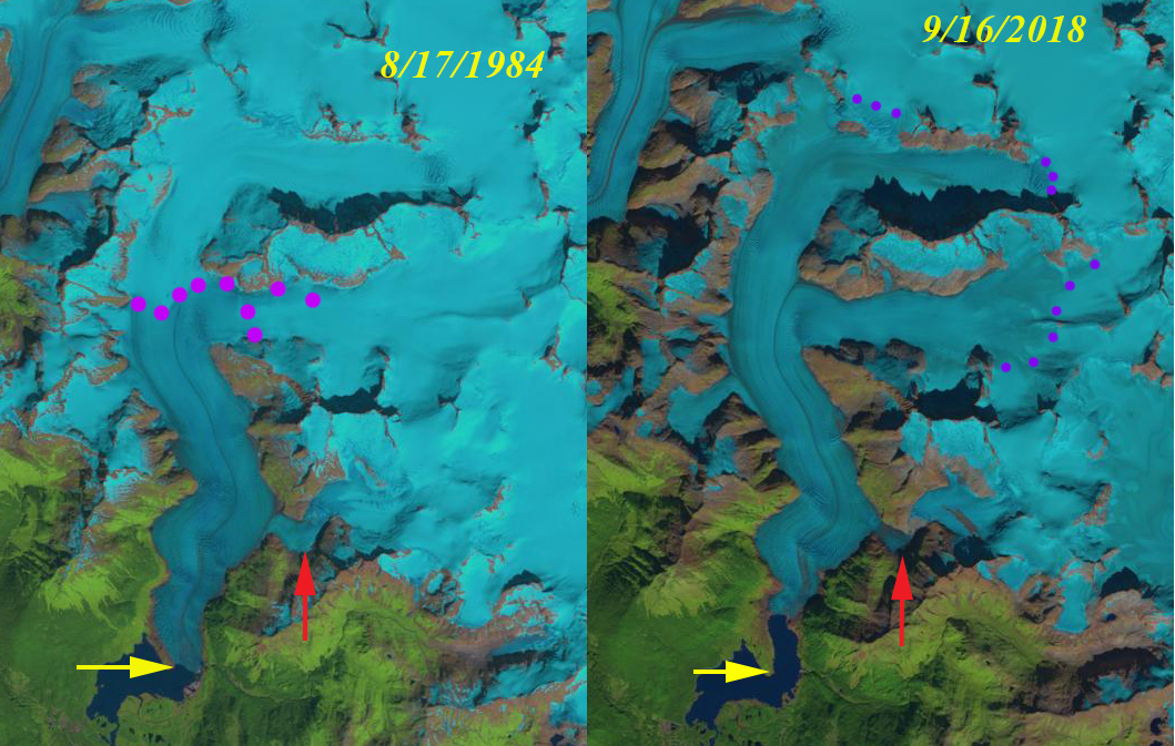
Mendenhall Glacier in Landsat images from 1984 and 2018.  Yellow arrows indicates 1984 terminus location, read arrow the Suicide Basin tributary and the purple dots the snowline.

Mendenhall Glacier is the most visited and photographed terminus in the Juneau Icefield region. The glacier can be seen from the suburbs of Juneau.  Its ongoing retreat from the Visitor Center and the expansion of the lake it fills is well chronicled.  Here we document the rise in the snowline on the glacier that indicates increased melting and reduced mass balance that has driven the retreat.  The change in snowline from 1984-2018 and the associated retreat are documented. The snowline as July begins in 2019 is already in the end of summer range.  In 1984 I had a chance to ski across the upper portion of this glacier. Photo736861842897_inner_76-402-615-387-84-752-620-741

Top of the Mendenhall Glacier at 1500 m looking towards ocean in 1984.

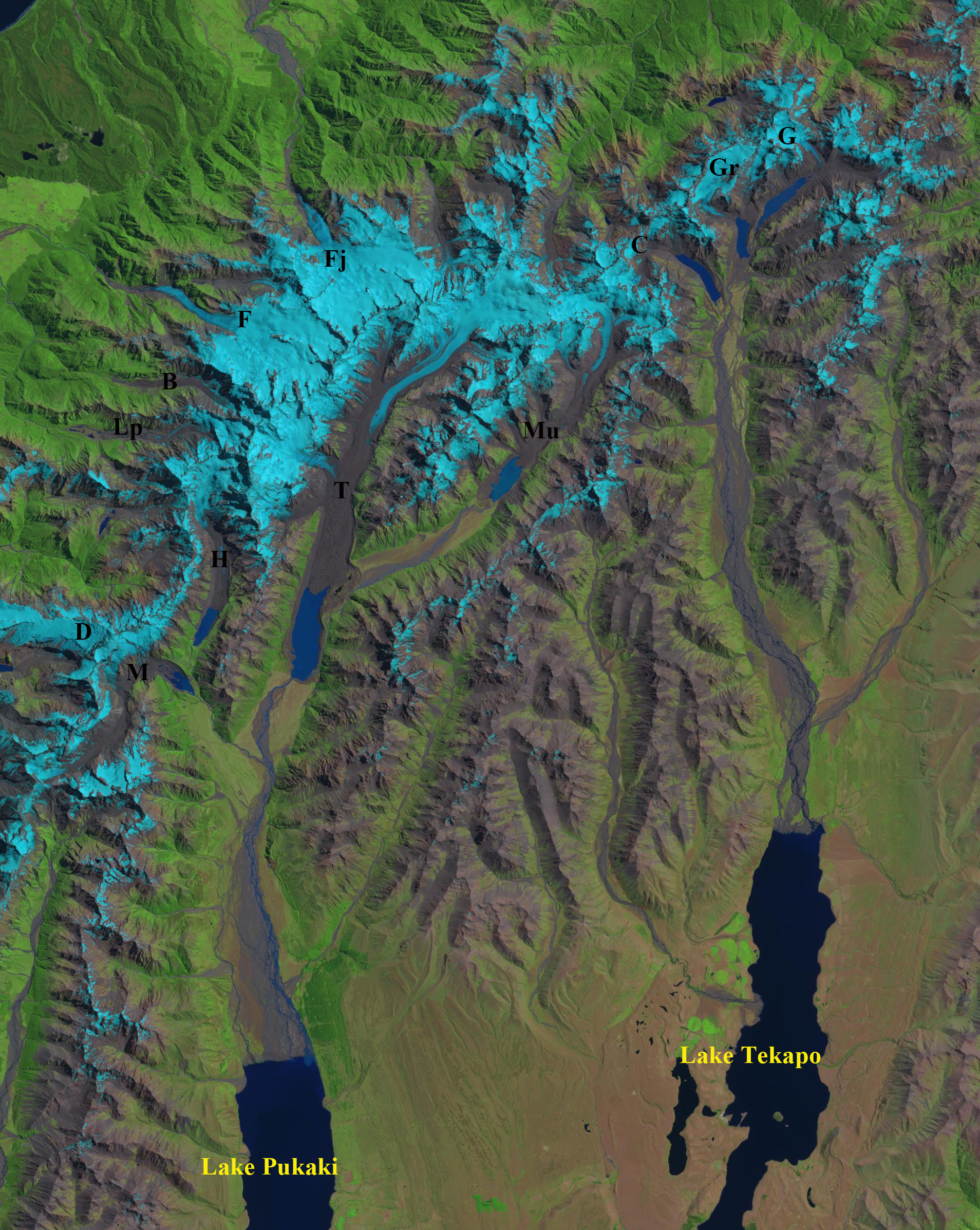
Mendenhall Lake did not exist until after 1910, in 1948 it was 2.2 km across and by 1984 the lake was 2.7 km across.  Boyce et al (2007) note the glacier had two period of rapid retreat one in the 1940’s and the second beginning in the 1990’s, both enhanced by buoyancy driven calving. The latter period has featured less calving particularly in the last decade and is a result of greater summer melting and a higher snowline by the end of the summer, which has averaged 1250 m since 2003 vs 1050 m prior to that (Pelto et al, 2016).  In 2005, the base of the glacier was below the lake level for at least 500 m upglacier of the terminus (Boyce et al (2007).  This suggests the glacier is nearing the end of the calving enhanced retreat.  It is likely another lake basin would develop 0.5 km above the current terminus, where the glacier slope is quite modest.

Photo736861827670_inner_51-268-606-268-57-633-606-633

Terminus of Mendenhall Glacier before the 1982 field season on the Juneau Icefield.

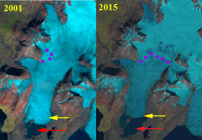
The glacier in 1984 ended at the tip of a prominent peninsula in Mendenhall Lake. The snowline is at 950 m. In 1984 with the Juneau Icefield Research Program we completed both snowpits and crevasse stratigraphy that indicated retained snowpack at the end of summer is usually more than 2 m at 1500-1600 m. The red arrow indicates a tributary that joins the main glacier, where Suicide Basin, currently forms. In 2014 the snowline in late August  is at 1050 m.  The terminus has retreated to a point where the lake narrows, which helps reduce calving. In 2015 the snowline is at 1475 m.  In  2017 the snowline reached 1500 m.  There is a small lake in Suicide Basin. In September 2018 the snowline reached 1550 m the highest elevation the snowline has been observed to reach any year.  In Suicide Basin the lake drained in early July. In 2018 Juneau Icefield Research Program snowpits indicates only 60% of the usual snowpack left on the upper Taku Glacier, near the divide with Mendenhall Glacier. On July 1. 2019 the snowline is already as high as it was in late August of 1984.  This indicates the snowline is likely to reach near a record level again.  The USGS and NWS is monitoring Suicide Basin for the drainage of this glacier melt filled lake. In 2019 the lake rapidly filled from early June until July 8, water level increasing 40 feet.  It has drained from July 8 to 16 back to it early June Level. The high melt rate has thinned the Mendenhall Glacier in the area reducing the elevation of the ice dam and hence the size of the lake in 2019 vs 2018.

The snowline separates the accumulation zone from the ablation (melting) zone and the glacier needs to have more than 60% of its area in the accumulation zone.  The end of summer snowline is the equilibrium line altitude where mass balance at the location is zero. With the snowline averaging 1500 m during recent years this leaves less 30% of the glacier in the accumulation zone. This will drive continued retreat even when the glacier retreats from Mendenhall Lake. The declining mass balance despite retreat is evident across the Juneau Icefield (Pelto et al 2013).  Retreat from 1984-2018 has been 1900 m.  This retreat is better known, but less than at nearby Gilkey Glacier and Field Glacier.

Mendenhall Glacier in Landsat image from 2014.  Yellow arrows indicates 1984 terminus location and the purple dots the snowline.

Mendenhall Glacier in Landsat image from 2015.  Yellow arrows indicates 1984 terminus location and the purple dots the snowline.

Mendenhall Glacier in Landsat image from 2017.  Yellow arrows indicates 1984 terminus location and the purple dots the snowline.

Mendenhall Glacier in Landsat image from 2019.  Yellow arrows indicates 1984 terminus location and the purple dots the snowline.

Sulmeneva Bay Glacier Retreat 1990-2018, Novaya Zemlya

Sulmeneva Bay Glacier in Landsat images from 1990 and 2018.  Red arrow is the 1990 terminus location, yellow arrow the 2018 terminus location and pink dots the snowline.

Here we examine an unnamed glaciers, referred to here as Sulmeneva Bay Glacier, that terminated in a piedmont lobe near the northern shore of Sulmeneva Bay and just east of Lednikovoye Lake in central Novaya Zemlya. Sulmeneva Bay is on the west coast of Novaya Zemlya and is the southern most extent of the continuous glaciation that extends along the northern half of the island.  LEGOS (2006) identified a 1.24 km2 reduction in area of this glacier from 1990-2000. Carr et al (2014) identified an average retreat rate of 52 meters/year for tidewater glaciers on Novaya Zemlya from 1992 to 2010 and 5 meters/year for land terminating glaciers. The glacier is retreating like all tidewater glaciers in northern Novaya Zemlya, though they are not specifically tidewater the lake terminating glaciers were retreating at a similar rate of ~40 m/year from 1986-2015 (Carr et al., 2017). Here we use Landsat images to examine changes from 1990 to 2018.

In 1990 Sulmeneva Bay Glacier terminates in a proglacial lake at the southern end of what will become an island in the lake. The lake is 1.1 km wide from the calving front to the southern shore, red arrow. The snowline in 1990 is at 550 m, while the head of the glacier is at 650 m.  By 2001 the glacier has retreated 700 m and the snowline is at 600 m reaching the ice divide in some areas. In 2015 the snowline is at 400 m and the lake has continued to expand with a north-south reach of 1.7 km. The glacier terminates at the northern end of the developing island.

In August of 2018 the snowline is at 550 m, again leaving a limited accumulation zone.  By mid-September snowfall has lowered the snowline back to 200 m.  The glacier has now retreated from the central island in the proglacial lake.  This should lead to an increase in calving. The glacier has retreated 1.2 km since 1990 and the lake is now 2.2 km from the calving front to the southern shore.

The retreat here is similar to the glaciers of Lednikovoye Lake and to Sulmeneva Glacier which retreated less, but across a broader front.  What is evident is that the persistent high snowlines are leading to negative mass balances that will drive continued retreat. At Lednikovoye Lake high snowlines in 2000 and 2016 further indicate the spatial extent and temporal frequency of high snowlines in recent years.

Sulmeneva Bay Glacier in Landsat images from 2010 and 2015.  Red arrow is the 1990 terminus location, yellow arrow the 2018 terminus location and pink dots the snowline.

Novaya Zemlya map produced by Christoph Hormann with Sulmeneva Bay Glacier (SSG) shown just west of Lednikovoye Lake.

Recent Climate Change Impacts on Mountain Glaciers – Volume

fig10-1

Landsat Image of glaciers examined in the Himalaya Range: Chapter 10 that straddles a portion of Sikkim, Nepal and Tibet, China. Notice the number that end in expanding proglacial lakes. 

This January a book I authored has been published by Wiley. The goal of this volume is to tell the story, glacier by glacier, of response to climate change from 1984-2015. Of the 165 glaciers examined in 10 different alpine regions, 162 have retreated significantly. It is evident that the changes are significant, not happening at a “glacial” pace, and are profoundly affecting alpine regions. There is a consistent result that reverberates from mountain range to mountain range, which emphasizes that although regional glacier and climate feedbacks differ, global changes are driving the response. This book considers ten different glaciated regions around the individual glaciers, and offers a different tune to the same chorus of glacier volume loss in the face of climate change. There are 107 side by side Landsat image comparisons illustrating glacier response.  Several examples are below: in each image red arrows indicate terminus positions from the 1985-1990 period and yellow arrows terminus positions for the 2013-2015 period, and purple arrows upglacier thinning.

[ngg_images source=”galleries” container_ids=”17″ display_type=”photocrati-nextgen_basic_imagebrowser” ajax_pagination=”1″ template=”/nas/wp/www/sites/blogsorg/wp-content/plugins/nextgen-gallery/products/photocrati_nextgen/modules/ngglegacy/view/imagebrowser-caption.php” order_by=”sortorder” order_direction=”ASC” returns=”included” maximum_entity_count=”500″]

There are chapters on: Alaska, Patagonia, Svalbard, South Georgia, New Zealand, Alps, British Columbia, Washington, Himalaya, and Novaya Zemlya. If you are a frequent reader of this blog you will recognize many of the locations. This updates each glacier to the same time frame. The book features 100 side by side Landsat image pairs illustrated using the same methods to illustrate change of each glacier. The combined efforts of the USGS and NASA in obtaining and making available these images is critical to examining glacier response to climate change. The World Glacier Monitoring Service inventory of field observations of terminus and mass balance on alpine glaciers is the another vital resource.  The key indicators that glaciers have been and are being significantly impacted by climate change are the global mass balance losses for 35 consecutive years documented by the WGMS.  The unprecendented global retreat that is increasing even after significant retreat has occurred in the last few decades (Zemp et al, 2015).  Last, the decline in area covered by glaciers in every alpine region of the world that is documented by mapping inventories such as the Randolph Glacier inventory and GLIMS ( Kargel et al 2014)

fig6-2

Landsat Image of glaciers examined in the Svalbard: Hornsund Fjord Region: Chapter 6.

fig5-1

Landsat Image of glaciers examined in the South Georgia Island: Chapter 5.

fig8-9

Landsat Image of Mount Baker glaciers examined in the North Cascades, Washington:  Chapter 8.

fig11-1

Landsat Image of glaciers examined in the Southern Alps of New Zealand S: Chapter 11.