Suhai Hu Ice Cap, China Outlet Glacier Retreat

Suhai Hu, Quilian Mountains Ice Cap in 1999 and 2016 Landsat image indicating five different outlet glacier termini that all ended in proglacial lakes in 1999 and all retreated significantly by 2016. 

Here we examine an unnamed icecap that I refer to as the “Suhai Hu” Ice Cap and five of its largest outlet glaciers in the Qilian Mountains in northwest China, with Landsat imagery from 1999-2016.  The northern outlet glaciers drain into the Suhai Hu and the southern outlet glaciers into Quidam Hu. Glaciers in the Gansu Province have shrunk by 36 square kilometers, a 4.2 percent loss, during the past decade Quiang (2016).  Tian et al (2014) report Qilian Mountain glacier area shrank by 30% from 1956 to 2010 and the shrinkage accelerated remarkably in the past two decades.  Yang et al (2015)  Results show that mountain glaciers in China are very vulnerable to climate change with 41% of glaciers having had a high vulnerability in the period 1961–2007.

In 1999 all five outlets, indicated by arrows terminate in proglacial lakes, with the northwest outlet comprise of two tributaries that join just above the terminus.  In 2001 the outlets still terminate in glacier lakes.  By 2015 two of the outlet glaciers at the orange and red arrow have retreated from the proglacial lakes they had terminated in.  The northwest outlet glacier, green arrow, the tributaries had separated.  From 1999 to 2016 the proglacial lake at the purple arrow has expanded from 600 m in length to 850 m.  The lake at the yellow arrow expanded from 450 m in length to 850 m in length from 1999-2016. each of the five outlet glaciers has retreated significantly from 1999-2016.  All 8 summer Landsat images examined indicate the ice cap always has substantial retained snowcover, and will not disappear with current climate. In a close up view of the terminus of the yellow outlet glacier there are prominent crevasses near the calving ice front, green arrow and supraglacial streams , blue arrows. The retreat here is similar to but less than that observed at Gangg’er Glacier in the Shule River Basin, Qilian Mountains. 

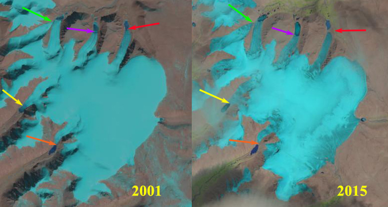
Suhai Hu, Quilian Mountains Ice Cap in 2001 and 2015 Landsat image indicating five different outlet glacier termini that all ended in proglacial lakes in 2001 and all retreated significantly by 2015.


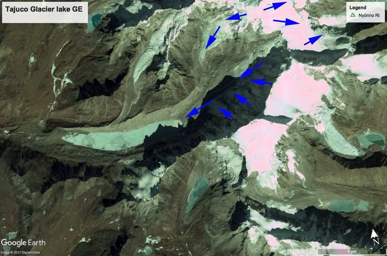
Google Earth image at the yellow outlet glacier. Green arrow indicates crevassing near front and blue arrows supraglacial streams. 

Tajuco Glacier Lake, China Expands with Glacier Retreat

Tajuco Glacier terminating in Tajuco Lake retreat in 1994 and 2017 Landsat comparison. Red arrow is 1997 terminus location, yellow arrow is the 2017 terminus location and the purple dots are the snowline in 2017. 

Tajuco Glacier Lake is a moraine dammed glacier lake in the Tingri district of China.  It drains into the Amur River which flows south into Nepal. Shijin et al (2015) reported on the expansion of the lake from 1990 to 2010 expanding from 0.65 square kilometers to 1.14 square kilometers.  They further reported that the Chinese Himalaya had 329 moraine dammed glacier lakes greater than 0.02 square kilometers in area, 116 of these posing a potential hazard, average size of 0.4 square kilometers. The number of lakes across the region is increasing (Kathmandu Post, 2017), though the number of GLOF’s has not.  The greater volume of expanding lakes puts more pressure on the moraine, the moraines if they have any ice core or permafrost can also weaken,  The moraines with time and distance from the glacier also can consolidate and become more stable.

In 1994 Tajuco Lake was 1.85 km long and had an area of about 0.7 square kilometers.  The snowline was at 6400 m.  In 1997 glacier retreat had led to an expansion of the lake to 2.05 km.  By 2016 the glacier retreat had led to expansion of the lake to a length of 3 km.  The snowline is at 6500 m near the crest of the glacier.  By 2017 the glacier had retreated 1200 m from 1994 to 2017, a rate of 24 m/year. The snowline was again at 6500 m near the crest of the glacier.  The high snowline indicates a glacier that will not survive. retreat will continue to expand the lake.  It is likely based on the Google Earth imagery below that the lake will not increase by more than 500 m in length, area in 2017 is 1.20 square kilometers. The retreat and lake expansion is similar to that of other glaciers on the north side of the Himalaya Range in China; Chaxiqudong Glacier, Chutanjima Glacier and Yanong Glacier. The high snowlines have been observed on nearby Rongbuk Glacier at Nup La and on Gangotri Glacier.

Tajuco Glacier terminating in Tajuco Lake retreat in 1997 and 2016 Landsat comparison. Red arrow is 1994 terminus location, yellow arrow is the 2017 terminus location and the purple dots are the snowline in 2016. 

Google Earth image of Tajuco Glacier illustrating flow.