Seward, Alaska Area Coastal Glacier Change 1986-2023

Change in terminus position of coastal glaciers in the Sewqrd region. On this 2023 Landsat image yellow dots are ther 2023 terminus and red dots the 1986 terminus.

Turn east along the coast from Seward Alaska and you are offshore of the Sargent Icefield, turn west and you are offshore of the Harding Icefield. Each has several large glaciers that were either tidewater or end in lakes separated from the ocean by a narrow coastal zone. Here we compare the response to climate change of seven of these glaciers from 1986-2023.

Change in terminus position of coastal glaciers in the Sewqrd region. On this 1986 Landsat image-yellow dots are ther 2023 terminus and red dots the 1986 terminus.

Travelling south down Resurrection Bay and turning east you enter into Day Harbor, at the head of which is the outlet for Ellsworth Glacier. The glacier terminates in an expanding lake that was 3.5 km long in 1986 and in 2023 is 8 km long. The 4000 m retreat generated some large icebers still in the lake.

Elsworth Glacier retreat from 2016-2020 leading to quick lake expansion in Landsat Images

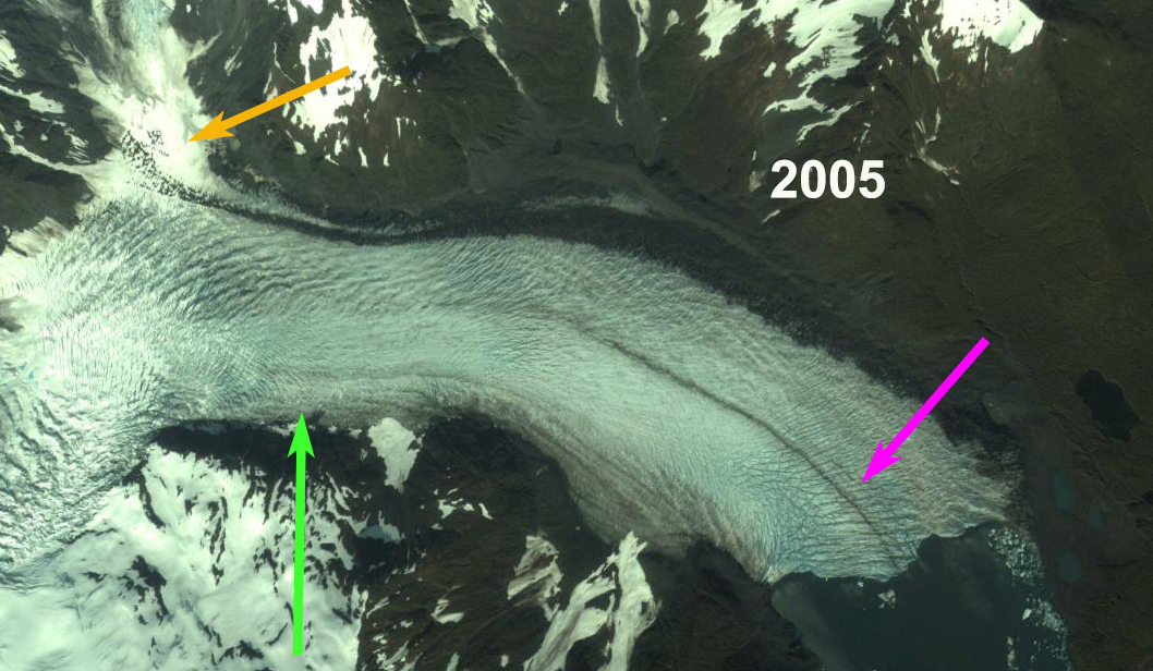
Travelling east from Day Harbor 15 km brings you into Johnstone Bay. Excelsior Glacier termiates just inland from the coast is a rapidly expanding lake. The lake was 5 km long in 1986, and by 2023 is 10.5 km long, a retreat of 5500 m. The glacier has separated with the Roan Glacier terminus to the east retreating from the lake. The Excelsior Glacier terminus currently is steep and nearing the north end of the lake.

Rapid expansion of Big Johnstone lake due to Excelsior Glacier retreat. Map from 1950, Landsat images 2001 and 2013.

Heading south down Resurection Bay on the western shore is Bear Glacier. From 1950-1986 the glacier retreated 160 m, and by 1980 the terminus was calving small icebergs into an ice-marginal lake that was beginning to develop. As thinning continued, much of the terminus became afloat by 2000. Bruce Molnia, USGS observed that passive calving, characterized by the release of large tabular icebergs from Bear’s low gradient, floating terminus became frequent. Between 2000 and 2007, the terminus retreated about 3.5 km, yielding large icebergs that floated in the lake. The amount of calving has declined from the period of more rapid retreat from 2002-2008. Black et al (2022) reported Bear Glacier retreating 5170 m. losing 17.28 km2 of area from 1984-2021. From 1986 to 2024 the glacier has retreated 6200 m, leading to a lake with an area of km2.

The retreat of Bear Glacier from 1986 to 2024 leading to growth of the lake to 22 km2, in Landsat images.

Continuing around Aialik Peninsula and traveling north into Aialik Bay, along the western shore is Pedersen Glacier. The glacier drops quickly from the plateau of the icefield through a pair of icefalls terminating in a lake at 25 meters above sea level.  Giffen et al (2014) observed that Pedersen Glacier retreated slow but steady from 1951-1986 at 706 m (20 m/a) and 434 m (23 m/year) from 1986-2005. Black et al (2022) reported a retreat of 3170 m and loss of 4.25 km2 from 1984-2021. We note a 3500 m retreat from 1986-2023.

Pederse Glacier retreat in Landsat images, leading to rapid lake expasion to 4 km2.

At the head of Aialik Bay is the tidewater Aialik Glacier. This glacier advanced 180 m from 1950-1986.From 1986-2006 the glacier retreated 290 m. Black et al (2022) observed the terminus was stable from 2000-2021 despite ongoing receession of the eastern margin of the glacier.

The Holgate Arm extends off of Aialik Bay on the west shore just south of Pedersen glacier. This tidewater glacier retreated 250 m from 1950-1986. The glacier has had several small periods of advance and retreat since 1986. Black et al (2022) note a period of advance from 2010-2021, the terminus has begun a small retreat from 2021-23 and is now just behind the 1986 position.

Northwestern Glacier is at the head of Northwestern Fjord off of Harris Bay, the next Bay west of Aialik Bay. This tidewater retreated 5200 m from 1950-1986, and an additional 1600 m since 1986. This retreat has led to a separation into two primary arms of the glacier. The rate of retreat has slowed since 2000 and the glaciers tidewater connection is limited, and will likely cease with even further minor retreat.

The Harding and Sargent icefield both have limited accumulation area above 1500 m. This means that they are prone to complete loss with a limited rise in snowline elevation. This is similar to the Juenau Icefield situation, where our research has indicated accelerated losses (APNews).

Pedersen Glacier, Alaska Rapid Retreat 1994-2015

Pedersen Glacier Kenia Peninsula, Alaska retreat from Landsat images in 1994 and 2016. The red arrow indicates 1994 terminus, yellow arrow is 2016 terminus, orange arrow indicates northern tributary and purple dots indicates snowline. 

Pedersen Glacier is an outlet glacier of the Harding Icefield in Kenai Fjords National Park near Seward, Alaska. The glacier drops quickly from the plateau of the icefield through a pair of icefalls terminating in a lake at 25 meters above sea level.  The Harding Icefield glaciers that drain east are in the Kenai Fjords National Park, which has a monitoring program.  Giffen et al (2014) observed that from 1950-2005 all 27 glaciers in the Kenai Icefield region examined retreated.  Giffen et al (2014) observed that Pedersen Glacier retreated slow but steady from 1951-1986 at 706 m (20 m/a) and 434 m (23 m/year) from 1986-2005. Here we compare a 1994, 2013, 2015 and 2016 Landsat imagery illustrating a rapid increase in retreat rate from the previous periods.

In 1994 the terminus proglacial lake at the terminus is small and much of the terminus is on land.  The snowline in 1994 is at 550 m.  The tributary entering from the north, orange arrow, is 400 m wide as it reaches Pedersen Glacier.  In 2005 the Google Earth image below indicates extensive terminus crevassing, indicating substantial terminus velocity, and that the retreat is driven by calving.  In 2005 the lake is now 1.1 km long on its center axis.  By 2015 the glacier has retreated 2600 m since 1994, a rate of 125 m/year, much faster than before.  The snowline is average 800 m.  The northern tributary is now barely reaching the main glacier and has a width of 150 m. Note there was a medial moraine separating the tributary from the main glacier in 1994 and now this is merely a lateral moraine. This tributary is not particularly impacted by calving losses and indicates a rising snowline is also a source of mass loss for the glacier. A comparison of the 2013, 2015 and 2016 terminus indicates the recession has remained rapid.  The glacier is approaching the base of an icefall that would represent the inland limit of the lake and the end of rapid retreat.  The snowline in 2013 averages 850 m and is at 800 m on Sept. 30 2016. The glacier follows the pattern of nearby Bear GlacierYakutat GlacierHarris Glacier and the inital phase of retreat on Brady Glacier.

Pedersen Glacier Kenia Peninsula, Alaska retreat from Landsat images in 2013 and 2015. The red arrow indicates 1994 terminus, yellow arrow is 2015 terminus, green arrow indicates 2016 terminus and purple dots indicates snowline. 

Pedersen Glacier in 2005, note crevassing at the terminus, pink arrow. The northern tributary is indicated by orange arrow and green arrow indicates 2016 terminus position. 

Pedersen Glacier Retreat Lake Expansion, Alaska

Pedersen Glacier is an outlet glacier of the Harding Icefield in Kenai Fjords National Park near Seward, Alaska. The glacier drops quickly from the plateau of the icefield through a pair of icefalls terminating 3.5 km in a lake at 25 meters. Bruce Molnia of the USGS as part of an effort in repeat photographs of Alaskan glaciers to show historic changes captures the changes of Pedersen Glacier. A photographic pair taken from about the same shoreline location of Pedersen Glacier. The photographs identify significant changes that have occurred during the 95 years between 1909 and 2004. The 2004 photograph a 1.5 km retreat of Pedersen Glacier from the field of view. In a recent study of the glaciers, by NASA and the NPS, (Hall et al, 2005) identify the retreat of the glacier as slow but steady from 1973-1986 at 510 m (35 m/a) and 110 m (8 m/year) from 1986-2000. Here we compare a 1994 Landsat, 2005 Google Earth, 2010 Landsat and 2011 Google Earth imagery illustrating a rapid increase in retreat rate from the previous periods. The red line in the Google Earth images is the 1994 terminus, the green line the 2005 terminus and the orange line the 2011 terminus. In 1994 the lake at the terminus is small and not continuous across the ice front (top image), the green dots are the terminus and the burgundy dots the snowline on the date of the image, near the top of the icefall. In the second image from 2005 the lake is now well developed but the number of icebergs in the lake limited. The third image from 2010 indicates a rapid lake expansion which is now largely filled by icebergs. In 2011 the lake remains filled with some very large icebergs indicating the recent nature of terminus collapse in the lake. The retreat from 1994-2005 was 450 meters (40 m/year) and 650 meters from 2005-2011,(110 m/year). The snowline is somewhat above the top of the icefalls on Pedersen Glacier. .. A closeup view of the terminus area from 2005 and 2011 indicate that the lake has more than doubled in size since 1994, and there is no distinct change in glacier width or surface elevation to suggest the glacier is near a point where the rapid terminus retreat will end. The glacier follows the pattern of nearby Bear Glacier, Yakutat Glacier, Gilkey Glacier and the predicted impending retreat of Brady Glacier.