Nellie Juan Glacier Loses Contact with Contact Glacier, Alaska

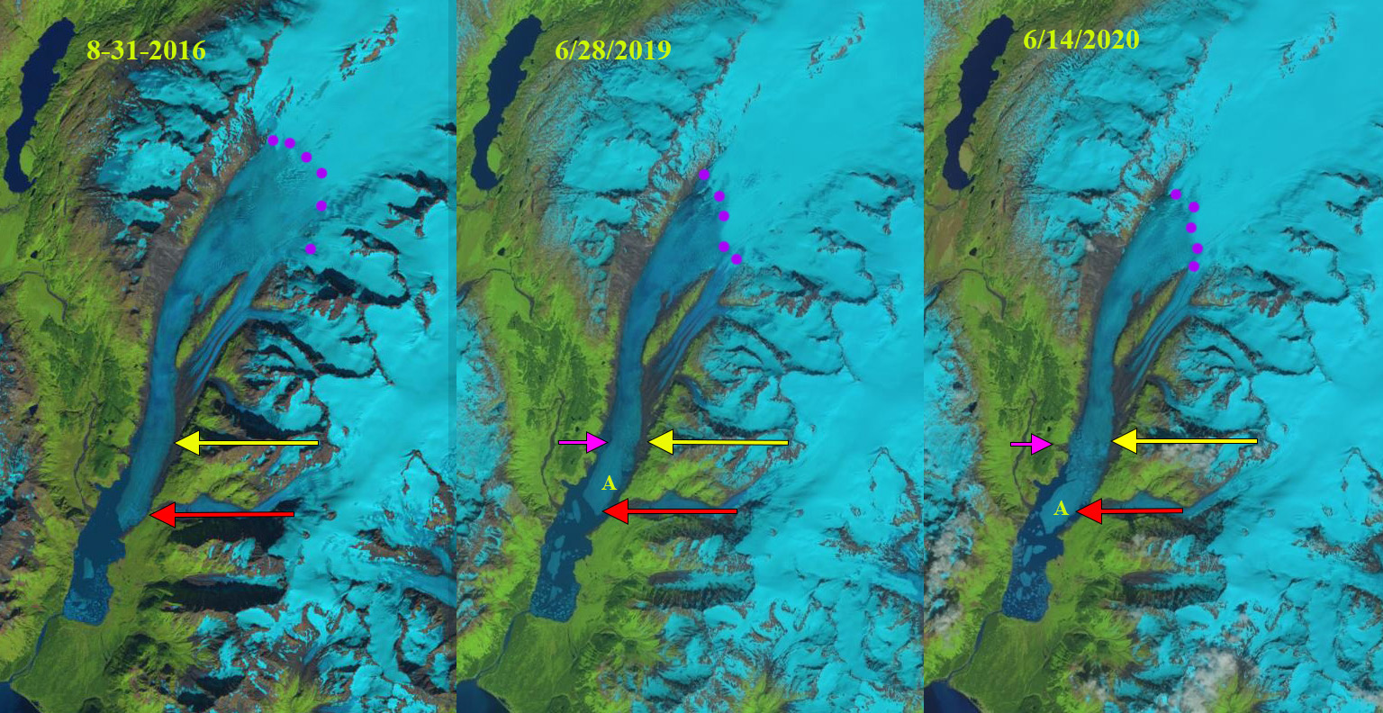
Nellie Juan Glacier (NJ) and Contact Glacier (C) in 1986 and 2020 Landsat images. Red arrow is the 1986 terminus location of both glaciers. Yellow arrow marks the terminus location in 2020 after glacier separation and purple dots mark the upper limit of Contact glacier at that time.

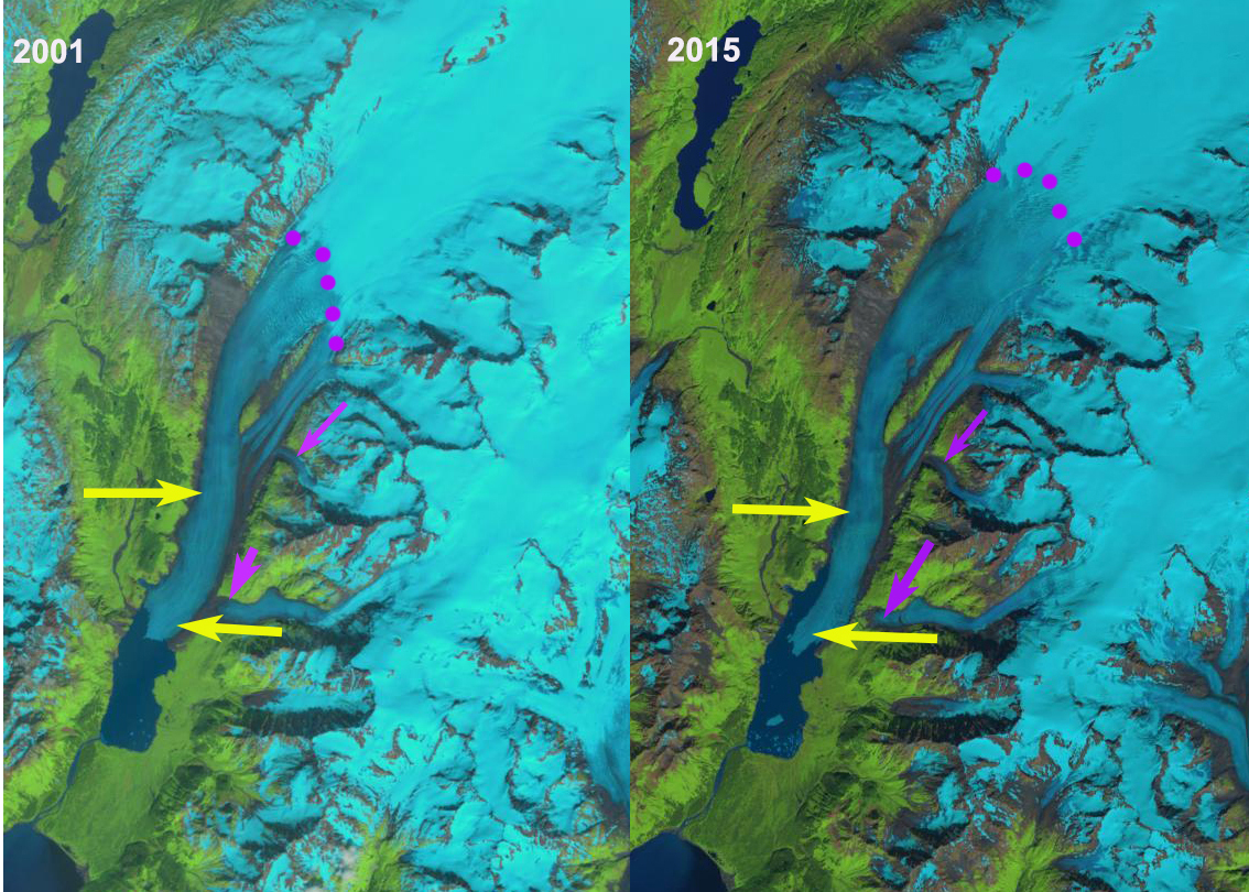
Nellie Juan Glacier is a tidewater outlet glacier of the Sargent Icefield, Alaska. Just after 1935 the glacier retreated from moraine shoal into deeper water of the fjord leading to a rapid calving retreat of 2250 m from 1950-2000, a rate of ~45 m/year (Barclay et al 2003).  The rate of retreat increased to ~124 m/year from 2006-2018 (Maraldo, 2020).  Harbor seals enjoy Port Nellie Juan and the icebergs from the glacier, with a population of ~44,000 identified in 2019 for the greater Prince William Sound region. From 1950-2018 Port Nellie Juan was fed in part by the Contact Glacier, a tributary that also had a separate terminus.  Here we examine the changes of Nellie Juan and Contact Glacier using Landsat imagery from 1986-2020.

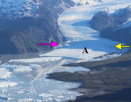
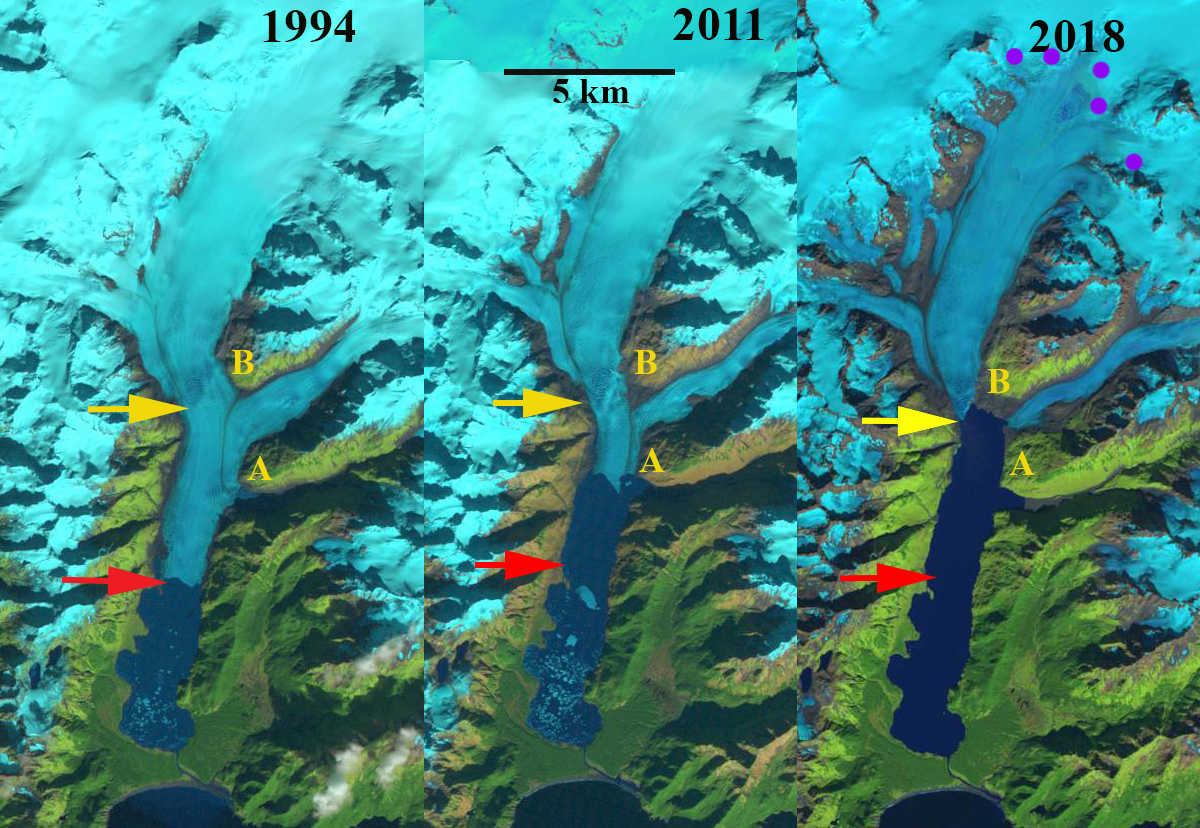
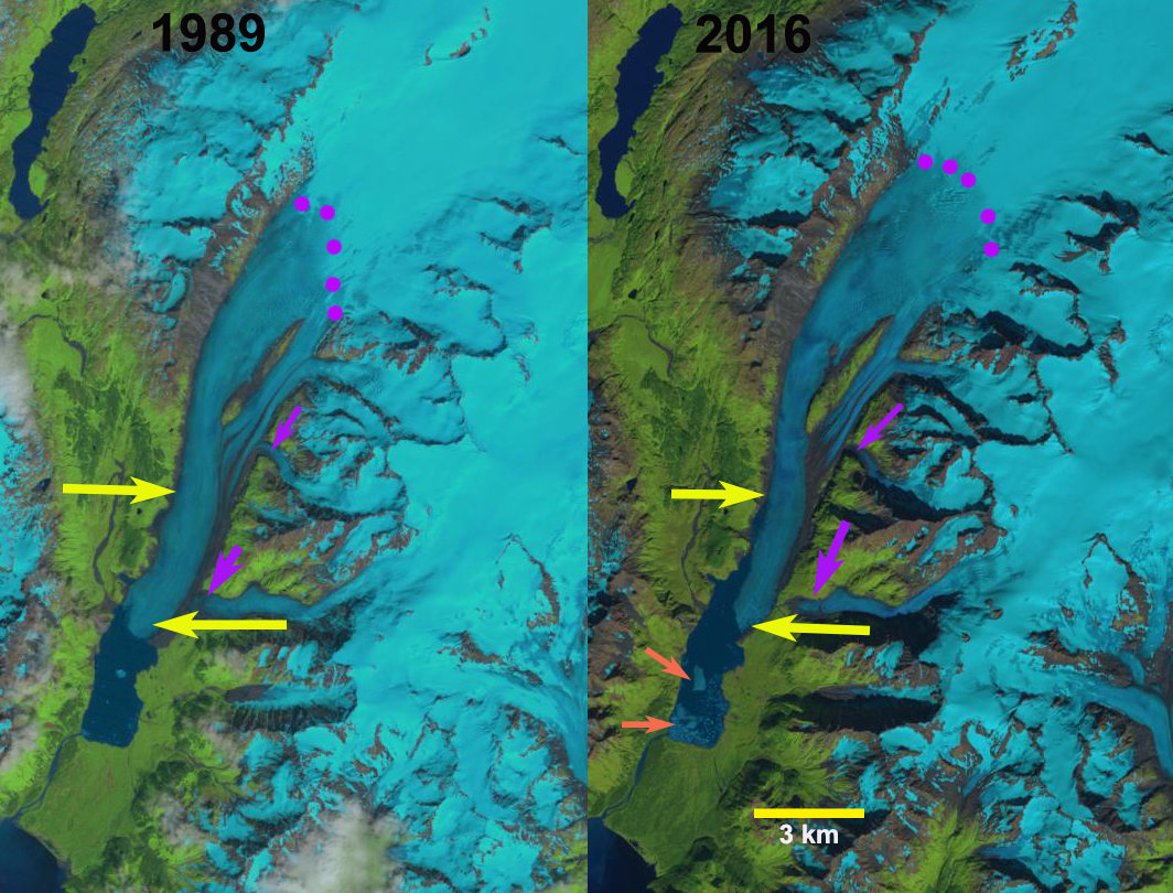
In 1986 the glacier terminated in a 0.5-km-wide calving front 1 km down fjord from the junction with Contact Glacier, which was 2 km wide. The snowline is at 500 m, the upper margin of Contact Glacier is indicated by purple dots and ranges from 400-500 m.  The retreat by 1994 is ~300 m, the snowline is at 500 m and Contact Glacier has almost no snowcover. In 2000 the connection with Contact Glacier is 1.9 km wide. By 2018 terminus retreat in the center of Nellie Juan Glacier since 1986 is 2500 m.  There is fringing connection of ice 300 m wide with Contact Glacier. Contact Glacier upper margin is now at 250 m, resulting in a more rapid retreat of the head of the glacier on the northern arm 1800 m since 1986, than that of the main terminus of Contact Glacier of 500 m. The snowline in 2018 is at 900 m, leaving the primary accumulation zone of Nellie Juan Glacier without snowcover.  In 2019 there is still a narrow connection between Nellie Juan and Contact Glacier. In 2020 the two glaciers have separated.  Contact Glacier, which had an area of 6.5 km2 in 1986, in 2020 has an area of 3.5 km2.  Contact Glacier has lacked an accumulation zone during most years in this period and cannot be sustained. Nellie Juan Glacier has retreated 2800 m along the former centerline and what is now its northern margin since 1986.  In 2020 the main accumulation area of Nellie Juan Glacier is again without snowcover, with a snowline above 900 m.

The glacier is terminating near a region of prominent crevassing indicating a bedrock step that may mark the head of the fjord. This will lead to an end to calving retreat and iceberg production, which will impact harbor seal haul out in the fjord (Jansen et al 2015). The retreat of Nellie Juan is less extensive than at Excelsior Glacier or Ellsworth Glacier draining the south side of the icefield. The percent loss in area of Contact Glacier is greater than other regional examples.

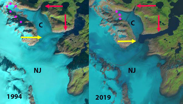
Nellie Juan Glacier (NJ) and Contact Glacier (C) in 1994 and 2019 Landsat images. Red arrow is the 1986 terminus location of both glaciers. Yellow arrow marks the terminus location in 2020 after glacier separation and purple dots mark the upper limit of Contact glacier at that time. In 2019 the glaciers are still connected.

Nellie Juan Glacier (NJ) and Contact Glacier (C) in 2000 and 2018 Landsat images. Red arrow is the 1986 terminus location of both glaciers. Yellow arrow marks the terminus location in 2020 after glacier separation and purple dots mark the upper limit of Contact glacier at that time. In 2018 the glaciers are still connected

Ellsworth Glacier, Alaska Calves Major Iceberg in 2020

Ellsworth Glacier in Landsat images from 2018, 2019 and 2020. Red arrow is the 2016 terminus location, yellow arrow is the 2020 termins location, pink arrow is the rift, purple dots is the snowline, iceberg is Point A. Glacier retreated 2.4 km, main iceberg 1 km2

Ellsworth Glacier is a valley glacier draining south from Sargent Icefield on the Kenai Peninsula in Alaska. Along with the Excelsior Glacier it has been the longest glacier of the icefield.  The glacier retreated into an expanding proglacial lake in the early 20th century (USGS-Molnia, 2008). The terminus in 2000 was reported to be  3.5 to 4.5 km from the 1908 position (USGS-Molnia, 2008).  In a previous post we examined Landsat images from 1989-2016 to identify the changes including a 500 m retreat on the east margin of the lake and a 3400 m retreat on the west margin.  It as noted that “this rapid lake expansion indicates that the lower 3 km of the glacier occupies a basin that will become a lake and that the tongue is partially afloat and given the narrowing thinning tongue is poised for collapse”.  Here we document that collapse with Landsat images from 2016-2020.

In 2016 the snowline is at 975 m, the lake has now extended 3 km along the western edge.  The terminus is just east of  a former tributary glacier, red arrow. The number of icebergs in 2016 indicates that significant ice calved during that year. The retreat of the eastern margin has been 500 m, with a 3.4 km retreat on the west margin.  The main tongue in the lower two kilometers is 800 m wide versus 1200 m wide in 1989.  In 2018 the snowline is at 1100 m, the terminus remains just west of a former tributary glacier.  There is a rift forming near the pink arrow, where an iceberg will eventually detach (A).  In late June of 2019 the rift has further developed, but the iceberg to be (A) has not detached.  By mid-August of 2019 the rift has nearly led to detachment of an iceberg (A), the snowline is at 1075 m.  In June of 2020 the iceberg has detached and there is a considerable melange of ice between the iceberg (A) and the main terminus.  By Sept. 11, 2020 the iceberg remains in much the same position.

The glacier has retreated 2.4 km since 2018, and now terminates at yellow arrow 1 km downglacier of the junction of the two main tributaries.  The iceberg has maintained an area of ~1 km2.  The snowline in 2020 is at 1125 m indicating another of mass balance loss for the glacier. The lake is now 7 km long and the lake area is ~7.5 kmup from 5 km2 in 2016. The retreat of this glacier paralells that of its neighbor Excelsior Glacier that retreated 4.7 km from 1994-2018. This continues to be a developing lake district including Grewingk Glacier.

Ellsworth Glacier in Landsat images from 2016-2020. Red arrow is the 2016 terminus location, yellow arrow is the 2020 termins location, pink arrow is the rift, purple dots is the snowline, iceberg is Point A.

Ellsworth Glacier in 2019. Point A is future iceberg is, yellow arrow is 2020 terminus locations and pink arrow is rift.  Image from Johnstone Adventure Lodge.

Excelsior Glacier, Alaska Retreat Leads to Lake Doubling in Size

Excelsior Glacier retreat from 1994 to 2018 in Landsat images from 1994, 2011 and 2018.  The red arrow is the 1994 terminus location and the yellow arrow is the 2018 terminus location.  Point A and B are on the south and northwest side of the eastern tributary of the glacier.

Excelsior Glacier is an outlet glacier of the Sargent Icefield, on the Kenai Peninsula of Alaska, that has terminated in an expanding Big Johnstone Lake since 1941. Here we examine the retreat of Excelsior Glacier from 1994-2018 using Landsat imagery. In 1909 the glacier ended on the strip of forested land between the lake and the ocean (Molnia, 2007). By 1950 the glacier had retreated 2 km from this strip of land creating the new lake (USGS-Molnia, 2008).  This blog post is source of an article published by the Washington Post and from NASA Earth Observatory.

In 1994 the glacier was 21 km long and had retreated 5.5 km from the southern margin of Big Johnstone Lake, this is a rate of ~100 m/year since the lake began forming 1941.  There is a glacier dammed lake just south of Point A named Excelsior Lake. By 2001 the glacier had retreated 800 m from the 1994 position, a rate of ~100 meters per year, and the glacier dammed lake south Point A remains, along with a few large icebergs. By 2011, the glacier had retreated beyond the former glacier dammed lake and ended at the prominent ridge just north of this former lake, adjacent to Point A, and the new inlet that replaces it. The glacier has retreated 2200-2500 m depending where on the front the measurement is made. By 2013 the glacier has retreated back to the junction of the two main tributaries between Point A and B.  The snowline is at 900 m, with more than 80% of the glacier falling below the snowline.  A calving Alaskan glacier typically needs at least 60% of its area above the snowline consistently to be in equilibrium. In 2011 and 2013 images there are large icebergs in Big Johnstone Lake indicating active calving. In 2018 the snowline is at 925 m again leaving an insufficient accumulation zone to support the glacier. Big Johnstone Lake has expanded to a length of 10.2 km, with an area of 18 km2.  The glacier has retreated 4.7 km from 1994-2018, a rate of ~200 m/year, twice the previous rate.  The eastern and western tributaries have now fully separated.  Johnstone Adventure Lodge visited the eastern tributary, they call it Roan Glacier, glacier in May of 2019, the photograph they provided below indicates the glacier has receded from the lake.  The glacier in 2018 is 15 km long having lost ~30% of its length in 24 years. Big Johnstone Lake is nearing its maximum size as the glacier surface slope steepens within 1 km of the current terminus, indicating a substantial increase in elevation of the base of the glacier. The lake width has changed little and is 1.4-1.8 km wide in the region the terminus has been retreating through during the last 25 years are has doubled from 9 to 18 km2.  There will be a reduction in calving and retreat rate as the lake development nears completion, in 2018 for the first time there are no visible icebergs. Johnstone Adventure Lodge observed 15-20 harbor seals during their first visit to the glacier front in 2019, 10 of them had pulled out on icebergs.  A reduction in icebergs will make the lake less attractive to harbor seals.

Excelsior Glacier follows the pattern of retreat of the neighboring Ellsworth Glacier and  Pedersen Glacier of the Harding Icefield. This glacier is seen as a model for the impending retreat of Brady Glacier (Pelto et al, 2013).

Excelsior Glacier retreat from 1994 to 2018 in 1984 USGS map and Landsat images from 2001 and 2013.  The red arrow is the 1994 terminus location and the yellow arrow is the 2018 terminus location.  Point A and B are on the south and northwest side of the eastern tributary of the glacier.

“Roan Glacier”  the eastern tributary of Excelsior Glacier in May 2019 now terminating on an outwash plain.  Image from Johnstone Adventure Lodge.

Ellsworth Glacier Retreat & Lake Expansion, Alaska

Ellsworth Glacier in 1989 and 2016 Landsat images.  Upper yellow arrow marks the west terminus in 2016 and the lower yellow the 2016 east margin.  Purple dots mark the snowline and purple arrows tributaries from the east that are thinning and disconnecting.  Orange arrow marks icebergs in the lake. 

Ellsworth Glacier is a valley glacier draining south from Sargent Icefield on the Kenai Peninsula in Alaska. Along with the Excelsior Glacier it has been the longest glacier of the icefield.  The glacier retreated into an expanding proglacial lake in the early 20th century (USGS-Molnia, 2008). The terminus in 2000 was reported to be  3.5 to 4.5 km from the 1908 position (USGS-Molnia, 2008).  Here we examine Landsat images to document changes from 1989 to 2016. 

In 1989 the snowline was at 925 m, purple dots, a tributary from the east joined just above the terminus, lower yellow arrow.  The terminus had a small embayment on the west side.  In 2001 the snowline was at 875 m, with little evident change in the terminus position.  By 2015 the tributary from the east has detached from the main glacier, the snowline is at 1000 m.  The lake has expanded considerably along the western margin and the tongue of the glacier has narrowed in the lower 2 km.  In 2016 the snowline is at 975 m, the lake has now extended 3 km along the western edge.  This rapid lake expansion indicates that the lower 3 km of the glacier occupies a basin that will become a lake and that the tongue is partially afloat and given the narrowing thinning tongue is poised for collapse, see below.  The number of icebergs in 2016 indicates that significant ice calved during that year. The retreat of the eastern margin has been 500 m, with a 3.4 km retreat on the west side.  The main tongue in the lower two kilometers is 800 m wide versus 1200 m wide in 1989.  It is also worth noting the greening of the elongated nuntak in the middle of the glacier several kilometers above terminus.  Along with the rapid 3.5 km retreat of the adjacent Excelsior Glacier, leaves the longest glacier from the icefield up for grabs. 

Ellsworth Glacier in 2001 and 2015 Landsat images.  Upper yellow arrow marks the west terminus in 2016 and the lower yellow the 2016 east margin.  Purple dots mark the snowline and purple arrows mark tributaries from the east that are thinning and disconnecting. 

Ellsworth Glacier in2016 Landsat image.  Upper yellow arrow marks the west terminus in 2016 and the lower yellow the 2016 east margin.  Purple arrows mark tributaries from the east that are thinning and disconnecting.  Orange arrow marks icebergs in the lake.